
Recomendados
Mais conteúdo relacionado
Mais procurados
Mais procurados (6)
Destaque
Último
Último (20)
WP10-69 Moose Hunt Modification
- 1. WP10-69 WP10-69 Executive Summary General Description Proposal WP10-69 requests the recognition of customary and traditional uses of moose in Unit 21E for residents of Lower Kalskag, Upper Kalskag, Aniak, and Chuathbaluk. The communities of Upper Kalskag, Aniak, and Chuathbaluk are located in Unit 19A;; Lower Kalskag is in Unit 18. Submitted by Kuskokwim Native Association Proposed Regulation Unit 21E—Moose Rural residents of Unit 21E, Aniak, Chuathbaluk, Kalskag, Lower Kalskag, and Russian Mission. OSM Preliminary Conclusion Support Proposal WP10-69 with modification to include only the Paimiut Slough area of Unit 21E and to exclude Chuathbaluk (see Map 3). The modified regulation should read: Customary and Traditional Use Determination Unit 21E—Moose South of a line beginning at the western boundary of Unit 21E near Tabernacle Mountain, extending easterly to the junction of Paimiut Slough and Innoko Slough, and southeasterly in the direction of Molybdenum Mountain to the juncture of Units 19A, 21A, and 21E—Residents of Unit 21E, Aniak, Kalskag, Lower Kalskag, and Russian Mission. Remainder—Residents of Unit 21E and Russian Mission. OSM Conclusion Support Proposal WP10-69 with modification to include only the area of Unit 21E south of Paimiut Slough (see Map 4). The modified regulation should read: Customary and Traditional Use Determination Unit 21E—Moose South of a line beginning at the western boundary of Unit 21E near the mouth of Paimiut Slough, extending easterly along the south bank of Paimiut Slough to Upper High Bank, and southeasterly in the direction of Molybdenum Mountain to the juncture of Units 19A, 21A, and 21E— Residents of Unit 21E, Aniak, Chuathbaluk, Kalskag, Lower Kalskag, and Russian Mission. Remainder—Residents of Unit 21E and Russian Mission. continued on next page Federal Subsistence Board Meeting 715
- 2. WP10-69 WP10-69 Executive Summary (continued) Western Interior Regional Support Proposal WP10-69 with modification to include only the Council Recommendation area of Unit 21E south of Paimiut Slough (see Map 4). The modified regulation would read: Customary and Traditional Use Determination Unit 21E—Moose South of a line beginning at the western boundary of Unit 21E near the mouth of Paimiut Slough, extending easterly along the south bank of Paimiut Slough to Upper High Bank, and southeasterly in the direction of Molybdenum Mountain to the juncture of Units 19A, 21A, and 21E— Residents of Unit 21E, Aniak, Chuathbaluk, Kalskag, Lower Kalskag, and Russian Mission. Remainder—Residents of Unit 21E and Russian Mission. Yukon-Kuskokwim Delta Support Proposal WP10-69 with modification described in the Regional Council OSM Preliminary Conclusion (to include only the Paimiut Slough area of Unit 21E;; see Map 3) with an additional modification to keep Chuathbaluk on the list of communities with a positive customary and traditional use determination. The modified regulation should read: Customary and Traditional Use Determination Unit 21E—Moose South of a line beginning at the western boundary of Unit 21E near Tabernacle Mountain, extending easterly to the junction of Paimiut Slough and Innoko Slough, and southeasterly in the direction of Molybdenum Mountain to the juncture of Units 19A, 21A, and 21E—Residents of Unit 21E, Aniak, Chuathbaluk, Kalskag, Lower Kalskag, and Russian Mission. Remainder—Residents of Unit 21E and Russian Mission. Interagency Staff Committee The Interagency Staff Committee found the staff analysis to be a Comments thorough and accurate evaluation of the proposal and that it provides sufficient basis for the Regional Council recommendations and Federal Subsistence Board action on the proposal. ADF&G Comments Although the Department supports this proposal in general, it is conditional. See full comments following the analysis. Written Public Comments None 716 Federal Subsistence Board Meeting
- 3. WP10-69 STAFF ANALYSIS WP10-69 ISSUES Proposal WP10-69, submitted by Kuskokwim Native Association (KNA), requests the recognition of customary and traditional uses of moose in Unit 21E for residents of Lower Kalskag, Upper Kalskag,1 Aniak, and Chuathbaluk. The communities of Upper Kalskag, Aniak, and Chuathbaluk are located in Unit 19A;; Lower Kalskag is in Unit 18. DISCUSSION The proposal is being submitted for all of Unit 21E;; however, the proponent states that it is the Paimiut Slough area that is customarily and traditionally used by Lower Kalskag, Upper Kalskag, Aniak, and Chuathbaluk (see Map 1), and it encourages the Western Interior Subsistence Regional Advisory Council to consider modifying the proposal to include that area only. The proponent further states that this proposal reflects comments received from residents of the communities named in the request, and that historically these communities depended on moose from Unit 21E to feed their families. In part, this request is being made because of the growing scarcity of moose in Unit 19A and the Kuskokwim River drainage portion of Unit 18 and regulatory restrictions that resulted beginning in 2003. The impetus for KNA to request a modification to the existing customary and traditional use determination for moose in Unit 21E is the closure and then removal of the State-managed winter moose hunt in Unit 21E in 2003/04. Only the Federal winter moose season has remained open, and as a consequence, the winter moose season has been closed to all but the Federally qualified communities of Grayling, Anvik, Shageluk and Holy Cross (collectively known as GASH) and Russian Mission. The GASH communities are in Unit 21E, and Russian Mission is located in Unit 18. While caribou can be harvested in Unit 21E under Federal subsistence regulations by residents of some communities in Unit 19A—Aniak, Chuathbaluk, and Crooked Creek—currently no community in Unit 19A is included in the customary and traditional use determination for moose in Unit 21E. Existing Federal Regulation Customary and Traditional Use Determination Unit 21E—Moose Rural residents of Unit 21E and Russian Mission. For the purposes of this analysis, Upper Kalskag is designated as “Upper” to clarify the difference between Upper 1 Kalskag and Lower Kalskag. Federal Subsistence Board Meeting 717
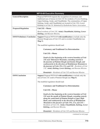
- 4. Placerville Unalakleet r r 718 v ive 0 15 30 R R im Miles WP10-69 kw ¹ ok Innoko National k k u us kK k K Wildlife Refuge o or F t th WP10-69 Map 1 or No º r er Unit 19A/21E: Moose ver iv rk Ri R n Fo Nixo Rive Ophir Medfra k o no Nikolai Grayling In Takotna r ve n McGrath So Ri u P Legend nat th itk F ko or Ta a F Yuko Unit Boundary k K ork Anvik Shageluk us k W BLM Lands ok in wi dy F m Iditarod FWS Refuge Lands R or k ive ver r i Paradise NPS Preserve Lands im R 21E Closed Area Bi River okw g R er ive iv r Holy Cross r R Kusk ive k e R o F or od or g ok st ar Ge r Paimiut Inn it Ea Rive Id r. Crooked Creek C Federal Subsistence Board Meeting Georgetown ose Mo 19A S on Red Devil Stony Riverwift R Yuk Sleetmute ive . Os ka r R wa w i ft Kalskag Chuathbaluk lik k S R or Aniak . F Napaimiut N. Ko Lower Kalskag Stony R lm Ho a iver Yukon Delta National A lo k ko Lime Village n ia uk f R Hoho k Ri ive Wildlife Refuge Ri r litn ver ver r ive a Riv Ca R n er tn a C li r. Bak Ho b uk Cr. Sparrevohn AFB r ive Lake Clark n R National Kashegelok mo Preserve l ver Sa Ri er iv uk R na ukl t ha ogr c K ul M
- 5. WP10-69 Proposed Federal Regulation Customary and Traditional Use Determination Unit 21E—Moose Rural residents of Unit 21E, Aniak, Chuathbaluk, Kalskag, Lower Kalskag, and Russian Mission. Extent of Federal Public Lands Federal public lands comprise approximately 55% of Unit 21E and consist of 79% Bureau of Land Management and 21% U.S. Fish and Wildlife Service lands (Map 1). Background A similar request was submitted by KNA to the Federal Subsistence Board (Board) in February 2008 in the form of a special action request (WSA08-01). The Board rejected the request in part because of the differences in the Yukon Kuskokwim Delta and Western Interior Councils’ recommendations suggesting that additional public participation and discussion was necessary. The Board encouraged KNA to submit a regular-cycle proposal. That regular cycle proposal is the topic of this analysis. As noted, this request was made in part because of the growing scarcity of moose in Unit 19A. In March 2006, ADF&G and the Board closed the eastern portion of Unit 19A to all moose hunting due to conservation concerns. Subsequently, in September 2006, hunting opportunity in the western portion of Unit 19A was reduced through Tier II and ANILCA Section 804. Initially, this occurred through a special action and emergency order but these restrictions were subsequently passed into regulation in May 2007. This situation has resulted in reduced opportunity and harvest of moose in all of Unit 19A, the primary area used by the proponents for hunting moose. Since the 2006/07 season, a State Tier II permit or a Federal permit has been required to hunt moose in Unit 19A. The Central Kuskokwim Moose Management Plan, published in June 2004, guides moose management in Units 19A and 19B (ADF&G 2004). For the Kuskokwim River drainage portion of Unit 18, in the fall of 2004 a five-year moratorium on moose hunting, intended to increase moose numbers, went into effect (ADF&G 2006:4). In September 2009, State-managed lands in this area opened for moose hunting with a quota of 75 moose. The hunting season was 10 days. For Unit 21E, the GASH Fish and Game Advisory Committee and State of Alaska Board of Game did not support the State winter season for antlerless moose in 2003/04 due to concerns about the possibility of a decline in the moose population (ADF&G 2006:3). The winter season has not opened since that time. State antlerless moose seasons require approval by a majority of the active advisory committees located in, or the majority of members reside in, the affected unit or subunit (see 5 AAC 98.005 and AS 16.05.780). The Federal winter moose season has remained open. Regulatory changes in units to the south of Unit 21E have caused increased concern about displaced hunters causing increased hunting pressure in Unit 21E (ADF&G 2006:4). However, in recent years the moose population has grown in the lower Yukon River area in Unit 18, which has resulted in fewer hunters traveling upriver (ADF&G 2006:1;; WIRAC 2010:187). Federal Subsistence Board Meeting 719
- 6. WP10-69 The Yukon-Innoko Moose Management Plan, published in December 2006, guides management actions in Units 21A and 21E (ADF&G 2006). An Adaptive Plan for Intensive Management of Moose in Unit 21E was completed by ADF&G in 2008 (2008a). The Working Group that drafted the Yukon- Innoko Moose Management Plan did not identify requests to expand the customary and traditional use determination for moose in Unit 21E as a major issue to be considered in the plan;; however, it recommended that “if the federal customary and traditional subsistence use determination (C&T) for Unit 21E is revised to make a large number of additional communities eligible, the federal winter season should be eliminated” (ADF&G 2006:22). The Working Group deferred further comment of customary and traditional use determinations to the Federal subsistence regional advisory councils representing the area (ADF&G 2006:23). Regulatory History This proposal is the first to request the expansion of the customary and traditional use determination for moose in Unit 21E to include Unit 19A communities. However, the Board has dealt with a number of proposals requesting the expansion of the customary and traditional use determination for moose in Unit 21E to include communities in Unit 18. The Board deferred those proposals until local users could work out a compromise, which has not been achieved. The current customary and traditional use determination for moose in Unit 21E, adopted from the State at the inception of the Federal Subsistence Management Program in 1990, is for rural residents of Unit 21E and Russian Mission. Aniak and Chuathbaluk are included in the customary and traditional use determination for moose in Unit 19 only. Upper Kalskag is included in the customary and traditional use determination for moose in Unit 18 and Unit 19 only. Lower Kalskag is included in the customary and traditional use determination for Unit 18, Unit 19A, and Unit 19B only. These customary and traditional use determinations were adopted from the State in 1990. Community Characteristics The communities of Upper Kalskag, Aniak, and Chuathbaluk are located along the middle Kuskokwim River in Unit 19A, and Lower Kalskag is located in Unit 18 downriver from the Unit 19A boundary and adjacent to Upper Kalskag. The unit boundary goes between the two villages that are otherwise connected. With the exception of a State-maintained 4.2-mile gravel road connecting Upper and Lower Kalskag, no road connections exist between the other communities (ADCCED 2008). However, boats are used to travel between villages, and trails and the frozen river are used by people on snow machines and ATVs during winter. A trail runs from the Paimiut Portage, linking Upper Kalskag to the now-abandoned village of Paimiut on the Yukon River (see Map 1;; Burch 1976:1–10). Before 1900, in the area of the above named communities, people lived in semi-permanent villages, often in semi-subterranean dwellings. Most people moved seasonally to harvest various species of fish and wildlife at sites within 30 miles of each other in a relatively fixed range (Fienup-Riordan 1984:68). Before 1900 many seasonal dwelling places and semi-permanent villages existed between present-day Lower Kalskag and Napaimute, such as Kolmakovski Redoubt, Crow Village, and Ohagamute. Several more permanent communities were established after an epidemic of influenza in 1900 when villages experiencing high death rates re-grouped into fewer villages—Kalskag,2 Ohagamute, Napaimute, and Crooked Creek. The migration to permanent communities continued to the 1950s at which time most 2 Before the village divided into two villages, Kalskag and Lower Kalskag. 720 Federal Subsistence Board Meeting
- 7. WP10-69 residents were living in permanent communities, traveling seasonally to temporary camps to harvest wild resources (Fienup-Riordan 1984:82–85). Between 1950 and 1960, another population shift occurred, prompted by the requirement to send children to school imposed by the territorial government (Nick 1984). Some Paimiut residents initially moved to Upper and Lower Kalskag along the Kuskokwim River, and then some of those people again relocated to Russian Mission in the 1960s (Pete 1991:18-19). Descendents of Paimiut residents currently reside in middle Kuskokwim communities, including Lower Kalskag, Upper Kalskag, and Aniak (Pete 1991:19;; YKDRAC 2008:79, 81–82). Mining and trading enterprises also contributed to the movement of people. Crow Village, an abandoned village that was located near present-day Chuathbaluk, and Paimiut were the farthest inland settlements whose residents spoke only Central Yup’ik (Oswalt and VanStone 1967:1). According to Charnley (1984), in 1983 Upper and Lower Kalskag, and Chuathbaluk were composed primarily of Yup’ik Eskimos. Sleetmute, Stony River, and Crooked Creek included individuals of both Yup’ik and Athabascan descent. Aniak, the regional center, was composed of both non-Native and Yup’ik people. Aniak is located approximately 26 miles upriver from Lower Kalskag, and 11 miles downriver from Chuathbaluk. In 2000 these four communities consisted of an estimated 1,200 people in 335 households (U.S. Census 2000;; Table 1). Table 1. Community population 1950 - 2000 and and number of households 2000 (Rollins 1978, U.S. Census 2000). Number of Community 1950 1960 1970 1980 1990 2000 Households in 2000 Lower Kalskag 88 122 183 246 297 267 66 Upper Kalskag 139 147 122 129 172 230 62 Aniak 142 308 205 341 540 572 174 Chuathbaluk 94 105 97 119 33 Total 369 577 604 821 1,106 1,188 335 Eight Factors for Determining Customary and Traditional Uses A community or area’s customary and traditional use is generally exemplified through the eight factors: (1) a long-term, consistent pattern of use, excluding interruptions beyond the control of the community or area;; (2) a pattern of use recurring in specific seasons for many years;; (3) a pattern of use consisting of methods and means of harvest which are characterized by efficiency and economy of effort and cost, conditioned by local characteristics;; (4) the consistent harvest and use of fish or wildlife as related to past methods and means of taking: near, or reasonably accessible from the community or area;; (5) a means of handling, preparing, preserving, and storing fish or wildlife which has been traditionally used by past generations, including consideration of alteration of past practices due to recent technological advances, where appropriate;; (6) a pattern of use which includes the handing down of knowledge of fishing and hunting skills, values, and lore from generation to generation;; (7) a pattern of use in which the harvest is shared or distributed within a definable community of persons;; and (8) a pattern of use which relates to reliance upon a wide diversity of fish and wildlife resources of the area and which provides substantial cultural, economic, social, and nutritional elements to the community or area. Federal Subsistence Board Meeting 721
- 8. WP10-69 The Board makes customary and traditional use determinations based on a holistic application of these eight factors (50 CFR 100.16(b) and 36 CFR 242.16(b)). In addition, the Board takes into consideration the reports and recommendations of any appropriate Regional Advisory Council regarding customary and traditional use of subsistence resources (50 CFR 100.16(b) and 36 CFR 242.16(b)). The Board makes customary and traditional use determinations for the sole purpose of recognizing the pool of users who generally exhibit the eight factors. The Board does not use such determinations for resource management or restricting harvest. If a conservation concern exists for a particular population, the Board addresses that concern through the imposition of harvest limits or season restrictions rather than by limiting the customary and traditional use finding. Specific information on each of the eight factors is not required because a community or area seeking a customary and traditional use determination only has to “generally exhibit” the eight factors (50 CFR 100.16(b) and 36 CFR 242.16(b)). A holistic evaluation of eight factors for residents of Lower Kalskag, Upper Kalskag, Aniak, and Chuathbaluk is described below. In the late 19th century, moose were not numerous in the Middle Kuskokwim Area, an area generally encompassing the Kuskokwim River drainage from Lower Kalskag to Stony River in Units 18 and 19 (Seavoy 2008);; however, caribou were more common (Charnley 1983:5). For example, according to John Kilbuck, a missionary for the Moravian Church who arrived in Bethel in 1885, during a trip upriver, Kilbuck wrote that a man near Napaimute shot four deer [caribou] with five bullets that were all he had. “To get home with the meat, he made a flat boat with two skins, and in this he descended a small creek, up/into the river and then on down” (Fienup-Riordan 1988:187). Additionally, Kilbuck wrote of the people of the Middle Kuskokwim Area: The Upper River people were the first to use firearms—from the blunder-buss with its flint and flash pan, whose chief value as a weapon of defense was the deafening report it could make, when fired. —A few of the old people still carry powder marks on their faces from the use of this ancient arm. The blunder-buss was replaced by the musket, and the musket was replaced by the Kentucky rifle. Now the latest improved repeating rifle is the equipment of the modern hunter (Fienup-Riordan 1988:7). Moose began entering this area in larger numbers in the early 1900s and populations have increased in size and distribution throughout the area since that time (Charnley 1983:5). The primary sources of information on resource use by residents of these communities contain observations made over 30 years ago: Brelsford et al.’s research in Aniak (Brelsford et al. 1987), Charnley’s work in Chuathbaluk (Charnley 1983, 1984), and Stickney’s central Kuskokwim food survey (Stickney 1981). All indicate that land mammals and salmon and nonsalmon fish were critical resources for these communities. An attempt to update these observations has been made through Krauthoefer and Koster’s (2006) research;; however, the findings focus on the results of household harvest surveys almost entirely and offer little insight into possible changes in moose use patterns of the residents of Lower Kalskag, Upper Kalskag, Aniak, and Chuathbaluk. Harvest and Use Levels In the area of these communities, as in much of rural Alaska, household surveys tend to provide a more accurate accounting of harvests than do returned harvest tickets (Andersen and Alexander 1992). Consequently, in 2003, 2004, and 2005, three 12-month household surveys were conducted to provide 722 Federal Subsistence Board Meeting
- 9. WP10-69 an accurate estimate of the number of moose taken by residents of these communities (Krauthoefer and Koster 2006) (Table 2). With the exception of a household survey at Chuathbaluk in 1983 (Charnley 1983), no other household surveys have been conducted for moose at Lower Kalskag, Upper Kalskag, Aniak, and Chuathbaluk. Table 2. Summary of household participation in harvest surveys that included moose, Aniak, Chuathbaluk, Lower Kalskag, and Upper Kalskag, all study years (ADF&G 2008b). Estimated Study Total Identified Surveyed Percentage Human Community Year Type of Sample Households Households of Total Population Aniak 2003 Census 163 82 50% 509 2004 Census 155 92 59% 492 2005 Census 168 74% 545 Chuathbaluk 1983 Census 29 29 100% 132 2003 Census 30 57% 125 2004 Census 23 17 74% 108 2005 Census 42 21 50% 124 Lower Kalskag 2003 Census 72 34 47% 303 2004 Census 73 81% 303 2005 Census 84 30 36% 336 Upper Kalskag 2003 Census 59 34 58% 243 2004 Census 52 96% 243 2005 Census 68 34 50% 266 The estimated harvest (from all areas) and use of moose during the four study years—1983, 2003, 2004, and 2005—at Lower Kalskag, Upper Kalskag, Aniak, and Chuathbaluk are reported in Table 3 and Table 4. The estimated moose harvest ranged from an annual high of 46 moose by Aniak residents in 2005, to a low of one moose by a Chuathbaluk resident in 2004 (Table 3). This difference between these two harvest numbers is in part because Aniak’s human population was much larger than Chuathbaluk’s population of people in the study years (Table 1;; U.S. Census 2000). Krauthoefer and Koster (2006) determined that in 2003, 2004, and 2005 moose were taken from Units 18, 19, and 21 by residents of the communities in the request (Table 5). No household from any of the four communities reported taking a moose in Unit 21E in 2003. In 2004 an estimated 6 moose total were taken in Unit 21E by residents of the four communities;; and in 2005, an estimated 5 moose total were taken in Unit 21E by residents of the four communities. This is 0%, 9%, and 8%, respectively, of the total moose harvest of all four communities combined in 2003, 2004, and 2005. However, Lower Kalskag and Chuathbaluk had no reported moose harvest in Unit 21E in any of the three survey years. It is important to note that residents of these communities were no longer eligible to participate in the winter hunt in Unit 21E beginning in 2003/2004. Another source of information is the ADF&G harvest ticket database. It should be noted that many rural Alaska areas have low compliance with harvest ticket systems (cf. Andersen and Alexander 1992). Because of the potential for under reporting, conventional ADF&G harvest reporting systems do not always reflect the true level of harvest. From 1983 to 2006 a cumulative total of 80 returned permits reported hunting in Unit 21E by residents of the four communities, and a cumulative total of 47 moose Federal Subsistence Board Meeting 723
- 10. WP10-69 Table 3. The use and harvest of moose based on household surveys, Aniak, Chuathbaluk, Lower Kalskag, and Upper Kalskag, all study years (ADF&G 2008b). Percentage of Households Moose Harvest Expanded Hunt- Harvest- Receiv- to House- 95% Con- Using ing ing Giving ing holds Not Lower Higher fidence Study Moose Moose Moose Moose Reported Surveyed Moose Estimate Estimate Interval Community Year (%) (%) (%) (%) (%) (Number) (Number) (Number) (Number) (+/- %) Aniak 2003 85 62 15 16 74 12 24 12 37 53 2004 80 71 23 24 65 23 38 25 51 33 2005 80 25 22 60 46 31 55 19 Chuathbaluk 1983 NA 72 24 NA NA 16 16 16 16 0 2003 29 18 18 24 5 3 10 103 2004 59 35 6 12 53 1 1 1 1 0 2005 29 10 0 24 4 2 10 147 Kalskag 2003 74 62 24 24 62 14 30 14 53 75 2004 36 41 17 8 24 10 12 10 15 29 2005 40 30 3 3 37 1 2 1 8 279 Upper Kalskag 2003 74 59 29 26 59 12 21 12 32 51 2004 72 16 14 64 9 9 9 10 14 2005 59 50 18 15 44 6 12 6 21 78 NA=not asked. Table 4. The harvest of moose by weight per household and per person from harvest surveys, Aniak, Chuathbaluk, Lower Kalskag, and Upper Kalskag, all study years (ADF&G 2008b). Moose Harvest Levels in Pounds Usable Percentage of Households Weighta 95% Using Hunting Harvesting Giving Receiving Per Per Confidence Study Moose Moose Moose Moose Moose Household Person Interval Community Year (%) (%) (%) (%) (%) (Pounds) (Pounds) (+/- %) Aniak 2003 85 62 15 16 74 79 25 53 2004 80 71 23 24 65 80 42.5 33 2005 80 25 22 60 109 46 19 Chuathbaluk 1983 NA 72 24 NA NA 394 87 0 2003 29 18 18 24 95 23 103 2004 59 35 6 12 53 24 9 0 2005 29 10 0 24 26 17 147 Lower Kalskag 2003 74 62 24 24 62 222 53 75 2004 36 41 17 8 24 74 25 29 2005 40 30 3 3 37 6 5 279 Upper Kalskag 2003 74 59 29 26 59 191 46 51 2004 72 16 14 64 94 26 14 2005 59 50 18 15 44 48 24 78 NA=not asked. a Conversion factor is 540 lb per moose. 724 Federal Subsistence Board Meeting
- 11. WP10-69 Table 5. Estimated harvest of moose by unit from household surveys, Aniak, Chuathbaluk, Lower Kalskag, and Upper Kalskag, 2003/04, 2004/05, and 2005/06 (Krauthoefer and Koster 2006).a Lower Upper Unit Kalskag Kalskag Aniak Chuathbaluk Total Percentage 2003/04 18 13 2 0 0 14 18% 19A 15 10 14 5 44 56% 19B 0 0 2 0 2 3% 19D 0 0 0 0 0 0% 21A 0 0 0 0 0 0% 21E 0 0 0 0 0 0% Unknown 2 9 8 0 19 24% Subtotal 30 21 24 5 80 100% 2004/05 18 1 3 0 0 4 7% 19A 11 4 29 1 45 73% 19B 0 0 0 0 0 0% 19D 0 0 2 0 2 3% 21A 0 0 3 0 3 5% 21E 0 2 3 0 6 9% Unknown 0 0 2 0 2 3% Subtotal 12 9 39 1 62 100% 2005/06 18 0 0 0 0 0 0% 19A 3 8 34 2 47 82% 19B 0 0 1 0 1 2% 19D 0 0 0 0 0 0% 21A 0 0 0 0 0 0% 21E 0 2 3 0 5 8% Unknown 0 2 0 2 4 7% Subtotal 3 12 38 4 57 100% a Residents of the four communities were not Federally qualified to participate in the Federal winter hunt in Unit 21E. Table 6. The moose harvest in Unit 1E 1983 - 2006 (ADF&G 2008c and 2008d). 1983-2006 Cumulative Reported Moose Harvest Number of Number Community Hunters Harvested Aniak 50 29 Chuathbulak 0 0 Lower Kalskag 11 9 Upper Kalskag 19 9 TOTAL 80 47 Federal Subsistence Board Meeting 725
- 12. WP10-69 harvests were reported in Unit 21E (Table 6). Only Chuathbaluk did not report hunting moose in Unit 21E during this period. For 2003, 2004, and 2005, survey results document that many households in the communities used moose, ranging from a high of 85% at Aniak in 2003, to a low of 29% at Chuathbaluk in 2003 and 2005 (Table 3). Many households attempted to harvest moose (ranging from 76% at Upper Kalskag in 2004, to 29% at Chuathbaluk in 2005), but few (16% and 0%, respectively) were successful. The harvests of moose by residents of Lower Kalskag, Upper Kalskag, Aniak, and Chuathbaluk are shared extensively with other households having kinship and other ties to hunters (Charnley 1983:35;; Krauthoefer and Koster 2006). Sharing was documented in 2003, 2004, and 2005, at Lower Kalskag, Upper Kalskag, Aniak and Chuathbaluk. For example, for the three study years in each community, between 24% and 74% of households reported receiving moose from other households (Table 3). Chuathbaluk Charnley’s (1983) research offers an in-depth view of the harvest and use of moose in Chuathbaluk. Although over 30 years old, the general use pattern she documented (including seasonality of harvests, work groups, and preferences) is probably being followed today. Some findings of her research, however, are probably less applicable, such as the lack of refrigeration for preserving moose meat. According to Charnley (1983), Chuathbaluk residents hunted moose year-round, however, the intensity of harvest effort was influenced by weather conditions and regulations. Moose were available to hunters July, August, and September in habitats such as willows bordering rivers, creeks, and lakes. Bulls and cows were especially fat during these months (Charnley 1983:9). Bulls entered the rut in late September. In October the better- tasting meat of cows was preferred. In fall, access to moose habitat was possible if and when rivers and creeks were swollen from heavy rain. However, moose were more sedentary in rainy weather and harder to find, and gravel bars, where moose could sometimes be found feeding, became submerged (Charnley 1983:10). Freeze-up along the middle Kuskokwim River usually occurred in November, and it was often unsafe for travel. Warm spells in winter could return rivers and creeks to dangerous conditions for travel by hunters. Deep snow aided hunting by allowing travel by snow machine, and by hampering moose mobility (Charnley 1983:11). At Chuathbaluk moose hunting was almost always engaged in by the adult and adolescent men (Charnley 1983:17). During September an extended family group that often included the wife, sisters, mother, and daughters of the hunters camped together for up to a week. At this time, generally, women and children gathered berries while men hunted moose and black bear. Sometimes two or three households camped together in one area. The November and February hunts usually involved the male members of a household only, and hunting occurred while checking trap lines and during day or overnight trips from the village. In February, camping was limited by cold weather (Charnley 1983:17). During house to house interviews residents of Chuathbaluk reported hunting moose in Unit 21E in the area of Paimiut, located in Unit 21E, in 1980–1983 (see Map 2, ADF&G 1986:Plate 3) . It is important to note that Chuathbaluk was re-established as a village in 1954 for religious purposes by people from other villages, including Aniak, Crooked Creek, Sleetmute, Upper Kalskag, Napaimute, and Crow Village (Charnley 1983:21–22). As a result, and perhaps not surprisingly, moose hunting areas documented by Charnley in 1983 reflected individuals’ affiliations to their original villages. These use areas, located in Unit 19, were described as follows, beginning with former community of residence: Upper Kalskag— the Whitefish Lake area;; Crow Village—Discovery and Swift creeks, and the Aniak River;; Aniak—the Aniak River;; Napaimute—the Holokuk River;; Crooked Creek—the Oskawalik and George rivers;; and Sleetmute—the Holitna and Hoholitna rivers. 726 Federal Subsistence Board Meeting