SlideShare uma empresa Scribd logo
1 de 1
Baixar para ler offline
An open database of DEM-derivatives of the World
T. Hengl & H.I. Reuter


Global DEM-derivatives                                                                                   Proposed implementation
The idea of a global repository of DEM-derivatives is not new. USGS has                                  The database needs to guarantee the following five criteria (Hengl & Reuter
been maintaining the global 1 km HYDRO1k (http://eros.usgs.gov) --- a                                    2008):
repository of DEM derivatives (elevation, WTI, slope, aspect, flow direction,
flow accumulation, drainage basins and streams). San Diego Supercomputer                                 Precision --- It needs to provide the best estimates of surface measures and
Center hosts a project called "Open Topography"                                                             objects, derived from the most accurate and current data and al-
(http://opentopography.org/) that aims at serving high resolution (LiDAR)                                   gorithms.
data and tools. Esri™ will build and host a collection of multiresolution DEM
                                                                                                         Multiscale --- Input DEM need to reside within a multi-scale GIS so that it can
derivatives, starting with SRTM and analytic services against it, as well as
                                                                                                            be available at various resolutions.
higher resolution DEM derivatives for places where the data is freely
available. The data will all be available for free on ArcGIS.com.                                        Open structure --- Users should be able to modify and adjust spatial queries
                                                                                                            to tailor surface measures and objects to fit specific needs.
                                                                                                         Web access --- The system should provide a high performance cached map
                                                                                                            services and interactive analytic functions as web services (e.g.
                                                                                                            viewshed and watershed delineation).
                                                                                                         Quality --- the input (DEMs) and algorithms should be continually evaluated
                                                                                                            and improved and maintained to ensure their fitness for use (minimum
                                                                                                            artifacts).

                                                                                                                                   Spatial query                    GEOMORPHOMETRIC ATLAS

                                                                                                                               Thematic properties
                                                                                                                                                                             DEM
                                                                                                                               - LSP/LSOs type
                                                                                                                               - algorithms
                                                                                                                               - pre-processing steps
                                                                                                                                                                                        Function
                                                                                                                                                                                         library
                                                                                                                               Spatial properties
                                                                                                                               - coordinate system
                                                                                                                               - spatial resolution                                          *Activate functions
                                                                                                                                                                            LSPs /           matching the best
                                                                                                                               - extent (boundaries)
Fig. 1: An example of a complete topographic model of the world at resolution of 1 km. For more info                                                                        LSOs             with users’ request
                                                                                                                                                                                              according to the
                    see: http://commons.wikimedia.org/wiki/File:Globedem.png                                                                                                                  organizer criteria


                                                                                                                                                        WEB-INTERFACE
On the other hand, it is difficult for a
single investigator or even one group to
undertake complex geomorphometry on a                                                                                               New data
                                                                                                                                                                            Outputs

global scale --- instead, cooperative                                                                                               type     date


initiatives (such as the
geomorphometry.org) are needed.
                                                                                                                          Fig. 3: Conceptual design for a geomorphometric atlas: a user defines

An open database of DEM-                                                                                                     various parameters and then downloads the data. Processing and
                                                                                                                              derivation of surface descriptors is done directly on the server.

derivatives                                                                                                                            LSP/LSO = Land Surface Parameters/Objects.


We propose here initiation of open                                                                       Conclusions
database of DEM derivatives (a geo-
morphometric atlas) --- an international                                                                 Demand for DEMs and their derivatives, evident from many different
network of mirrored servers that will host                                                               disciplines and applications, will prompt ever higher expectations for rigor
the largest collection of DEM derived                                                                    and force the global scientific community to commit to an ongoing review of
products including reference methods,                                                                    data standards. The Global DEM-derivatives initiative is a platform for
software tools and standards.                                                                            meeting these expectations.
                                                         Fig. 2: The landform classification following
Such geo-database would support the        Iwahashi and Pike (2007). Relief classes                      References:
                                         which are classified using an unsupervised
development of knowledge libraries, as           nested-means algorithms.
                                                                                                          Hengl, T., Reuter, H.I. (eds) 2008. Geomorphometry: Concepts, Software, Applications. Developments in Soil Science,
                                                                                                          vol. 33, Elsevier, 772 pp.
well as continued testing and comparison                                                                  Kleiner, K., 2011. Data on demand. Nature Climate Change 1, 10–12.
of geomorphometric methods by the scientific community (Kleiner, 2011).                                   Iwahashi, J. and R. J. Pike, 2007. "Automated classifications of topography from DEMs by an unsupervised nested-
                                                                                                          means algorithm and a three-part geometric signature." Geomorphology 86(3-4): 409-440.


ISRIC - World Soil Information, Wageningen University
PO Box 353, 6700 AJ Wageningen, the Netherlands
URL: http://www.isric.org
E-mail: {tom.hengl; hannes.reuter}@wur.nl

Mais conteúdo relacionado

Mais procurados

Using Artificial Neural Networks for Digital Soil Mapping – a comparison of M...
Using Artificial Neural Networks for Digital Soil Mapping – a comparison of M...Using Artificial Neural Networks for Digital Soil Mapping – a comparison of M...
Using Artificial Neural Networks for Digital Soil Mapping – a comparison of M...
Ricardo Brasil
 
Gis Applications Presentation
Gis Applications PresentationGis Applications Presentation
Gis Applications Presentation
Idua Olunwa
 
Lind robam valgma_sokman_developing_computational_groundwater_monitoring_and_...
Lind robam valgma_sokman_developing_computational_groundwater_monitoring_and_...Lind robam valgma_sokman_developing_computational_groundwater_monitoring_and_...
Lind robam valgma_sokman_developing_computational_groundwater_monitoring_and_...
Ingo Valgma
 
Investigation of the Lake Victoria Region (Africa: Tanzania, Kenya and Uganda)
Investigation of the Lake Victoria Region (Africa: Tanzania, Kenya and Uganda)Investigation of the Lake Victoria Region (Africa: Tanzania, Kenya and Uganda)
Investigation of the Lake Victoria Region (Africa: Tanzania, Kenya and Uganda)
Universität Salzburg
 

Mais procurados (20)

Bhuvan
Bhuvan Bhuvan
Bhuvan
 
Optimizing GIS based Systems
Optimizing GIS based SystemsOptimizing GIS based Systems
Optimizing GIS based Systems
 
Srinivas_Resume
Srinivas_ResumeSrinivas_Resume
Srinivas_Resume
 
Bhuvan and DIVA-GIS software Training
Bhuvan and DIVA-GIS software TrainingBhuvan and DIVA-GIS software Training
Bhuvan and DIVA-GIS software Training
 
SEI OSGIS presentation
SEI OSGIS presentationSEI OSGIS presentation
SEI OSGIS presentation
 
Using Artificial Neural Networks for Digital Soil Mapping – a comparison of M...
Using Artificial Neural Networks for Digital Soil Mapping – a comparison of M...Using Artificial Neural Networks for Digital Soil Mapping – a comparison of M...
Using Artificial Neural Networks for Digital Soil Mapping – a comparison of M...
 
Development of a Prototype Web GIS Server for HDF-EOS Data based on OGC Web M...
Development of a Prototype Web GIS Server for HDF-EOS Data based on OGC Web M...Development of a Prototype Web GIS Server for HDF-EOS Data based on OGC Web M...
Development of a Prototype Web GIS Server for HDF-EOS Data based on OGC Web M...
 
Gis capabilities on Big Data Systems
Gis capabilities on Big Data SystemsGis capabilities on Big Data Systems
Gis capabilities on Big Data Systems
 
Kopss Open API 단위테스트 이슈사항
Kopss Open API 단위테스트 이슈사항Kopss Open API 단위테스트 이슈사항
Kopss Open API 단위테스트 이슈사항
 
Landslide graphical analysis
Landslide graphical analysis Landslide graphical analysis
Landslide graphical analysis
 
Aster vnir & swir band enhancement for lithological mapping a case study of...
Aster vnir & swir band enhancement for lithological mapping   a case study of...Aster vnir & swir band enhancement for lithological mapping   a case study of...
Aster vnir & swir band enhancement for lithological mapping a case study of...
 
Thematic Data Dissemination on bhuvan
Thematic Data Dissemination on bhuvanThematic Data Dissemination on bhuvan
Thematic Data Dissemination on bhuvan
 
Advanced KML with GRASS GIS
Advanced KML with GRASS GIS Advanced KML with GRASS GIS
Advanced KML with GRASS GIS
 
Ijetcas14 474
Ijetcas14 474Ijetcas14 474
Ijetcas14 474
 
Geographic inf system
Geographic inf systemGeographic inf system
Geographic inf system
 
SmartGeo - G. Satta
SmartGeo - G. SattaSmartGeo - G. Satta
SmartGeo - G. Satta
 
Theme m 2
Theme   m 2Theme   m 2
Theme m 2
 
Gis Applications Presentation
Gis Applications PresentationGis Applications Presentation
Gis Applications Presentation
 
Lind robam valgma_sokman_developing_computational_groundwater_monitoring_and_...
Lind robam valgma_sokman_developing_computational_groundwater_monitoring_and_...Lind robam valgma_sokman_developing_computational_groundwater_monitoring_and_...
Lind robam valgma_sokman_developing_computational_groundwater_monitoring_and_...
 
Investigation of the Lake Victoria Region (Africa: Tanzania, Kenya and Uganda)
Investigation of the Lake Victoria Region (Africa: Tanzania, Kenya and Uganda)Investigation of the Lake Victoria Region (Africa: Tanzania, Kenya and Uganda)
Investigation of the Lake Victoria Region (Africa: Tanzania, Kenya and Uganda)
 

Destaque

Geomorphology applications
Geomorphology applicationsGeomorphology applications
Geomorphology applications
vyshalik
 
Settlement Characteristics
Settlement CharacteristicsSettlement Characteristics
Settlement Characteristics
whiskeyhj
 
Map Skills Revision
Map Skills RevisionMap Skills Revision
Map Skills Revision
whiskeyhj
 
Settlement Patterns
Settlement PatternsSettlement Patterns
Settlement Patterns
Jiexin Zhang
 

Destaque (13)

SAGA GIS 2.0.7
SAGA GIS 2.0.7SAGA GIS 2.0.7
SAGA GIS 2.0.7
 
2015 FOSS4G Track: Analyzing Aspen's Community Forest with Lidar, Object-Base...
2015 FOSS4G Track: Analyzing Aspen's Community Forest with Lidar, Object-Base...2015 FOSS4G Track: Analyzing Aspen's Community Forest with Lidar, Object-Base...
2015 FOSS4G Track: Analyzing Aspen's Community Forest with Lidar, Object-Base...
 
Qgis OpenlayersPlugin
Qgis OpenlayersPluginQgis OpenlayersPlugin
Qgis OpenlayersPlugin
 
Report GFZ
Report GFZReport GFZ
Report GFZ
 
MORPHOMETRIC ANALYSIS OF SUKE SUB-WATERSHED OF TAWA RESERVOIR CATCHMENT AREA ...
MORPHOMETRIC ANALYSIS OF SUKE SUB-WATERSHED OF TAWA RESERVOIR CATCHMENT AREA ...MORPHOMETRIC ANALYSIS OF SUKE SUB-WATERSHED OF TAWA RESERVOIR CATCHMENT AREA ...
MORPHOMETRIC ANALYSIS OF SUKE SUB-WATERSHED OF TAWA RESERVOIR CATCHMENT AREA ...
 
Morphometry and Hydrology relationship in Lidder valley
Morphometry and Hydrology relationship in Lidder valleyMorphometry and Hydrology relationship in Lidder valley
Morphometry and Hydrology relationship in Lidder valley
 
2 hydro-geomorphology
2  hydro-geomorphology2  hydro-geomorphology
2 hydro-geomorphology
 
Geomorphology and its application to hydrogeology
Geomorphology and its application to hydrogeologyGeomorphology and its application to hydrogeology
Geomorphology and its application to hydrogeology
 
Geomorphology applications
Geomorphology applicationsGeomorphology applications
Geomorphology applications
 
Settlement Characteristics
Settlement CharacteristicsSettlement Characteristics
Settlement Characteristics
 
Map Skills Revision
Map Skills RevisionMap Skills Revision
Map Skills Revision
 
Morphometric analysis of a vrishabhavathi sub watershed upstream side of gali...
Morphometric analysis of a vrishabhavathi sub watershed upstream side of gali...Morphometric analysis of a vrishabhavathi sub watershed upstream side of gali...
Morphometric analysis of a vrishabhavathi sub watershed upstream side of gali...
 
Settlement Patterns
Settlement PatternsSettlement Patterns
Settlement Patterns
 

Semelhante a Hengl & Reuter poster at Geomorphometry.org/2011

Arc gis introduction-ppt
Arc gis introduction-pptArc gis introduction-ppt
Arc gis introduction-ppt
Ashok Peddi
 
Towards and adaptable spatial processing architecture
Towards and adaptable spatial processing architectureTowards and adaptable spatial processing architecture
Towards and adaptable spatial processing architecture
Armando Guevara
 
Introduction toarcgis editorforosm
Introduction toarcgis editorforosmIntroduction toarcgis editorforosm
Introduction toarcgis editorforosm
Taichi Furuhashi
 
JGrass and Hydrology
JGrass and HydrologyJGrass and Hydrology
JGrass and Hydrology
posterVienna
 
Realini go gps_foss4g2011_small2
Realini go gps_foss4g2011_small2Realini go gps_foss4g2011_small2
Realini go gps_foss4g2011_small2
masarunarazaki
 

Semelhante a Hengl & Reuter poster at Geomorphometry.org/2011 (20)

Evolution of Esri Data Formats Seminar
Evolution of Esri Data Formats SeminarEvolution of Esri Data Formats Seminar
Evolution of Esri Data Formats Seminar
 
Data managing and Exchange GDB
Data managing and Exchange GDB Data managing and Exchange GDB
Data managing and Exchange GDB
 
Arc gis introduction-ppt
Arc gis introduction-pptArc gis introduction-ppt
Arc gis introduction-ppt
 
Towards and adaptable spatial processing architecture
Towards and adaptable spatial processing architectureTowards and adaptable spatial processing architecture
Towards and adaptable spatial processing architecture
 
Creating Web Applications with ArcGIS
Creating Web Applications with ArcGIS Creating Web Applications with ArcGIS
Creating Web Applications with ArcGIS
 
Introduction toarcgis editorforosm
Introduction toarcgis editorforosmIntroduction toarcgis editorforosm
Introduction toarcgis editorforosm
 
Subsurface 3D GIS 05nov2011
Subsurface 3D GIS 05nov2011Subsurface 3D GIS 05nov2011
Subsurface 3D GIS 05nov2011
 
GeoIQ Stack - Where 2012
GeoIQ Stack - Where 2012GeoIQ Stack - Where 2012
GeoIQ Stack - Where 2012
 
Watershed Delineation in ArcGIS
Watershed Delineation in ArcGISWatershed Delineation in ArcGIS
Watershed Delineation in ArcGIS
 
Apache Hadoop MapReduce: What's Next
Apache Hadoop MapReduce: What's NextApache Hadoop MapReduce: What's Next
Apache Hadoop MapReduce: What's Next
 
ArcGIS and Multi-D: Tools & Roadmap
ArcGIS and Multi-D: Tools & RoadmapArcGIS and Multi-D: Tools & Roadmap
ArcGIS and Multi-D: Tools & Roadmap
 
JGrass and Hydrology
JGrass and HydrologyJGrass and Hydrology
JGrass and Hydrology
 
3rd presentation
3rd presentation3rd presentation
3rd presentation
 
ADVANCE DATABASE MANAGEMENT SYSTEM CONCEPTS & ARCHITECTURE by vikas jagtap
ADVANCE DATABASE MANAGEMENT SYSTEM CONCEPTS & ARCHITECTURE by vikas jagtapADVANCE DATABASE MANAGEMENT SYSTEM CONCEPTS & ARCHITECTURE by vikas jagtap
ADVANCE DATABASE MANAGEMENT SYSTEM CONCEPTS & ARCHITECTURE by vikas jagtap
 
Hadoop mapreduce and yarn frame work- unit5
Hadoop mapreduce and yarn frame work-  unit5Hadoop mapreduce and yarn frame work-  unit5
Hadoop mapreduce and yarn frame work- unit5
 
Low cost solutions for Lidar and GIS analysis
Low cost solutions for Lidar and GIS analysisLow cost solutions for Lidar and GIS analysis
Low cost solutions for Lidar and GIS analysis
 
GIS Data Types
GIS Data TypesGIS Data Types
GIS Data Types
 
EOSC-hub & Geohazards TEP
EOSC-hub & Geohazards TEPEOSC-hub & Geohazards TEP
EOSC-hub & Geohazards TEP
 
Realini go gps_foss4g2011_small2
Realini go gps_foss4g2011_small2Realini go gps_foss4g2011_small2
Realini go gps_foss4g2011_small2
 
Intro To Geospatial
Intro To GeospatialIntro To Geospatial
Intro To Geospatial
 

Mais de Tomislav Hengl

Open Soil Profiles - testbed data portal for storing soil profile data
Open Soil Profiles - testbed data portal for storing soil profile dataOpen Soil Profiles - testbed data portal for storing soil profile data
Open Soil Profiles - testbed data portal for storing soil profile data
Tomislav Hengl
 

Mais de Tomislav Hengl (12)

Introducing GSIF (seminar at Lamont campus)
Introducing GSIF (seminar at Lamont campus)Introducing GSIF (seminar at Lamont campus)
Introducing GSIF (seminar at Lamont campus)
 
Poster "Global Soil Information Facilities"
Poster "Global Soil Information Facilities"Poster "Global Soil Information Facilities"
Poster "Global Soil Information Facilities"
 
A statistical assessment of GDEM using LiDAR data
A statistical assessment of GDEM using LiDAR dataA statistical assessment of GDEM using LiDAR data
A statistical assessment of GDEM using LiDAR data
 
Open Soil Profiles - testbed data portal for storing soil profile data
Open Soil Profiles - testbed data portal for storing soil profile dataOpen Soil Profiles - testbed data portal for storing soil profile data
Open Soil Profiles - testbed data portal for storing soil profile data
 
Drupal course hengl
Drupal course henglDrupal course hengl
Drupal course hengl
 
Worldgrids.org: building global covariates for automated mapping
Worldgrids.org: building global covariates for automated mappingWorldgrids.org: building global covariates for automated mapping
Worldgrids.org: building global covariates for automated mapping
 
Space-time data workshop at IfGI
Space-time data workshop at IfGISpace-time data workshop at IfGI
Space-time data workshop at IfGI
 
Global soilmap at_afsis_hengl
Global soilmap at_afsis_henglGlobal soilmap at_afsis_hengl
Global soilmap at_afsis_hengl
 
Spatial interpolation comparison
Spatial interpolation comparisonSpatial interpolation comparison
Spatial interpolation comparison
 
DSM training - preparing auxiliary data
DSM training - preparing auxiliary dataDSM training - preparing auxiliary data
DSM training - preparing auxiliary data
 
R crash course
R crash courseR crash course
R crash course
 
Latex crash course
Latex crash courseLatex crash course
Latex crash course
 

Último

Beyond the EU: DORA and NIS 2 Directive's Global Impact
Beyond the EU: DORA and NIS 2 Directive's Global ImpactBeyond the EU: DORA and NIS 2 Directive's Global Impact
Beyond the EU: DORA and NIS 2 Directive's Global Impact
PECB
 
1029-Danh muc Sach Giao Khoa khoi 6.pdf
1029-Danh muc Sach Giao Khoa khoi  6.pdf1029-Danh muc Sach Giao Khoa khoi  6.pdf
1029-Danh muc Sach Giao Khoa khoi 6.pdf
QucHHunhnh
 
Making and Justifying Mathematical Decisions.pdf
Making and Justifying Mathematical Decisions.pdfMaking and Justifying Mathematical Decisions.pdf
Making and Justifying Mathematical Decisions.pdf
Chris Hunter
 
An Overview of Mutual Funds Bcom Project.pdf
An Overview of Mutual Funds Bcom Project.pdfAn Overview of Mutual Funds Bcom Project.pdf
An Overview of Mutual Funds Bcom Project.pdf
SanaAli374401
 
1029 - Danh muc Sach Giao Khoa 10 . pdf
1029 -  Danh muc Sach Giao Khoa 10 . pdf1029 -  Danh muc Sach Giao Khoa 10 . pdf
1029 - Danh muc Sach Giao Khoa 10 . pdf
QucHHunhnh
 

Último (20)

Measures of Dispersion and Variability: Range, QD, AD and SD
Measures of Dispersion and Variability: Range, QD, AD and SDMeasures of Dispersion and Variability: Range, QD, AD and SD
Measures of Dispersion and Variability: Range, QD, AD and SD
 
Beyond the EU: DORA and NIS 2 Directive's Global Impact
Beyond the EU: DORA and NIS 2 Directive's Global ImpactBeyond the EU: DORA and NIS 2 Directive's Global Impact
Beyond the EU: DORA and NIS 2 Directive's Global Impact
 
Application orientated numerical on hev.ppt
Application orientated numerical on hev.pptApplication orientated numerical on hev.ppt
Application orientated numerical on hev.ppt
 
Class 11th Physics NEET formula sheet pdf
Class 11th Physics NEET formula sheet pdfClass 11th Physics NEET formula sheet pdf
Class 11th Physics NEET formula sheet pdf
 
Key note speaker Neum_Admir Softic_ENG.pdf
Key note speaker Neum_Admir Softic_ENG.pdfKey note speaker Neum_Admir Softic_ENG.pdf
Key note speaker Neum_Admir Softic_ENG.pdf
 
Unit-V; Pricing (Pharma Marketing Management).pptx
Unit-V; Pricing (Pharma Marketing Management).pptxUnit-V; Pricing (Pharma Marketing Management).pptx
Unit-V; Pricing (Pharma Marketing Management).pptx
 
Introduction to Nonprofit Accounting: The Basics
Introduction to Nonprofit Accounting: The BasicsIntroduction to Nonprofit Accounting: The Basics
Introduction to Nonprofit Accounting: The Basics
 
Grant Readiness 101 TechSoup and Remy Consulting
Grant Readiness 101 TechSoup and Remy ConsultingGrant Readiness 101 TechSoup and Remy Consulting
Grant Readiness 101 TechSoup and Remy Consulting
 
1029-Danh muc Sach Giao Khoa khoi 6.pdf
1029-Danh muc Sach Giao Khoa khoi  6.pdf1029-Danh muc Sach Giao Khoa khoi  6.pdf
1029-Danh muc Sach Giao Khoa khoi 6.pdf
 
Ecological Succession. ( ECOSYSTEM, B. Pharmacy, 1st Year, Sem-II, Environmen...
Ecological Succession. ( ECOSYSTEM, B. Pharmacy, 1st Year, Sem-II, Environmen...Ecological Succession. ( ECOSYSTEM, B. Pharmacy, 1st Year, Sem-II, Environmen...
Ecological Succession. ( ECOSYSTEM, B. Pharmacy, 1st Year, Sem-II, Environmen...
 
Making and Justifying Mathematical Decisions.pdf
Making and Justifying Mathematical Decisions.pdfMaking and Justifying Mathematical Decisions.pdf
Making and Justifying Mathematical Decisions.pdf
 
Mehran University Newsletter Vol-X, Issue-I, 2024
Mehran University Newsletter Vol-X, Issue-I, 2024Mehran University Newsletter Vol-X, Issue-I, 2024
Mehran University Newsletter Vol-X, Issue-I, 2024
 
An Overview of Mutual Funds Bcom Project.pdf
An Overview of Mutual Funds Bcom Project.pdfAn Overview of Mutual Funds Bcom Project.pdf
An Overview of Mutual Funds Bcom Project.pdf
 
ICT Role in 21st Century Education & its Challenges.pptx
ICT Role in 21st Century Education & its Challenges.pptxICT Role in 21st Century Education & its Challenges.pptx
ICT Role in 21st Century Education & its Challenges.pptx
 
1029 - Danh muc Sach Giao Khoa 10 . pdf
1029 -  Danh muc Sach Giao Khoa 10 . pdf1029 -  Danh muc Sach Giao Khoa 10 . pdf
1029 - Danh muc Sach Giao Khoa 10 . pdf
 
Paris 2024 Olympic Geographies - an activity
Paris 2024 Olympic Geographies - an activityParis 2024 Olympic Geographies - an activity
Paris 2024 Olympic Geographies - an activity
 
Holdier Curriculum Vitae (April 2024).pdf
Holdier Curriculum Vitae (April 2024).pdfHoldier Curriculum Vitae (April 2024).pdf
Holdier Curriculum Vitae (April 2024).pdf
 
Presentation by Andreas Schleicher Tackling the School Absenteeism Crisis 30 ...
Presentation by Andreas Schleicher Tackling the School Absenteeism Crisis 30 ...Presentation by Andreas Schleicher Tackling the School Absenteeism Crisis 30 ...
Presentation by Andreas Schleicher Tackling the School Absenteeism Crisis 30 ...
 
Unit-IV; Professional Sales Representative (PSR).pptx
Unit-IV; Professional Sales Representative (PSR).pptxUnit-IV; Professional Sales Representative (PSR).pptx
Unit-IV; Professional Sales Representative (PSR).pptx
 
Mixin Classes in Odoo 17 How to Extend Models Using Mixin Classes
Mixin Classes in Odoo 17  How to Extend Models Using Mixin ClassesMixin Classes in Odoo 17  How to Extend Models Using Mixin Classes
Mixin Classes in Odoo 17 How to Extend Models Using Mixin Classes
 

Hengl & Reuter poster at Geomorphometry.org/2011

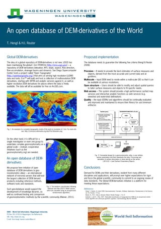
  • 1. An open database of DEM-derivatives of the World T. Hengl & H.I. Reuter Global DEM-derivatives Proposed implementation The idea of a global repository of DEM-derivatives is not new. USGS has The database needs to guarantee the following five criteria (Hengl & Reuter been maintaining the global 1 km HYDRO1k (http://eros.usgs.gov) --- a 2008): repository of DEM derivatives (elevation, WTI, slope, aspect, flow direction, flow accumulation, drainage basins and streams). San Diego Supercomputer Precision --- It needs to provide the best estimates of surface measures and Center hosts a project called "Open Topography" objects, derived from the most accurate and current data and al- (http://opentopography.org/) that aims at serving high resolution (LiDAR) gorithms. data and tools. Esri™ will build and host a collection of multiresolution DEM Multiscale --- Input DEM need to reside within a multi-scale GIS so that it can derivatives, starting with SRTM and analytic services against it, as well as be available at various resolutions. higher resolution DEM derivatives for places where the data is freely available. The data will all be available for free on ArcGIS.com. Open structure --- Users should be able to modify and adjust spatial queries to tailor surface measures and objects to fit specific needs. Web access --- The system should provide a high performance cached map services and interactive analytic functions as web services (e.g. viewshed and watershed delineation). Quality --- the input (DEMs) and algorithms should be continually evaluated and improved and maintained to ensure their fitness for use (minimum artifacts). Spatial query GEOMORPHOMETRIC ATLAS Thematic properties DEM - LSP/LSOs type - algorithms - pre-processing steps Function library Spatial properties - coordinate system - spatial resolution *Activate functions LSPs / matching the best - extent (boundaries) Fig. 1: An example of a complete topographic model of the world at resolution of 1 km. For more info LSOs with users’ request according to the see: http://commons.wikimedia.org/wiki/File:Globedem.png organizer criteria WEB-INTERFACE On the other hand, it is difficult for a single investigator or even one group to undertake complex geomorphometry on a New data Outputs global scale --- instead, cooperative type date initiatives (such as the geomorphometry.org) are needed. Fig. 3: Conceptual design for a geomorphometric atlas: a user defines An open database of DEM- various parameters and then downloads the data. Processing and derivation of surface descriptors is done directly on the server. derivatives LSP/LSO = Land Surface Parameters/Objects. We propose here initiation of open Conclusions database of DEM derivatives (a geo- morphometric atlas) --- an international Demand for DEMs and their derivatives, evident from many different network of mirrored servers that will host disciplines and applications, will prompt ever higher expectations for rigor the largest collection of DEM derived and force the global scientific community to commit to an ongoing review of products including reference methods, data standards. The Global DEM-derivatives initiative is a platform for software tools and standards. meeting these expectations. Fig. 2: The landform classification following Such geo-database would support the Iwahashi and Pike (2007). Relief classes References: which are classified using an unsupervised development of knowledge libraries, as nested-means algorithms. Hengl, T., Reuter, H.I. (eds) 2008. Geomorphometry: Concepts, Software, Applications. Developments in Soil Science, vol. 33, Elsevier, 772 pp. well as continued testing and comparison Kleiner, K., 2011. Data on demand. Nature Climate Change 1, 10–12. of geomorphometric methods by the scientific community (Kleiner, 2011). Iwahashi, J. and R. J. Pike, 2007. "Automated classifications of topography from DEMs by an unsupervised nested- means algorithm and a three-part geometric signature." Geomorphology 86(3-4): 409-440. ISRIC - World Soil Information, Wageningen University PO Box 353, 6700 AJ Wageningen, the Netherlands URL: http://www.isric.org E-mail: {tom.hengl; hannes.reuter}@wur.nl