
Recomendados
Mais conteúdo relacionado
Mais procurados
Mais procurados (18)
Destaque
Semelhante a Managing Bluff Vegetation at Sunrise Park
Semelhante a Managing Bluff Vegetation at Sunrise Park (20)
Managing Bluff Vegetation at Sunrise Park
- 1. Sunrise Park and Beach Bluff Vegetative Management Report P. Clifford Miller, Inc. July, 2012 Landscape Architecture Natural Areas Management
- 2. 2
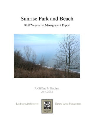
- 3. Introduction Sunrise Park and Beach is located in the town of Lake Bluff in Lake County, Illinois, and is owned and managed by the Lake Bluff Park District. The park is comprised of a linear section of tableland approximately eighteen hundred feet in length, overlooking a bluff averaging roughly seventy feet in height, the toe of which forms the west border of the sand beach, which is the primary active recreation area. Shabica & Associates Sunrise beach A paved road is cut into the bluff which services the North Shore Sanitary District Facility located at the base of the bluff as well as providing a point of access for the Park District to manage and maintain the beach and various beach facilities. The Lake Bluff Yacht Club maintains a boat storage facility to the south of the NSSD building. There are gravel pedestrian pathways and wooden stairs. Path to beach 3
- 4. The tableland is comprised of scattered native timber at various densities, the remnants of an old mesic forest that once occupied the site. Most of the intermediate sized trees and the shrub and native herbaceous layers have long since been removed. Mowed lawn covers the entire area, typically from the street right to the very edge of the bluff. To the south of Prospect Avenue, the upper Park is rather rectilinear in shape and is approximately 2 1/4 acres in size. From Prospect Avenue north to Mountain Avenue, the tableland becomes quite narrow, roughly twenty-five feet on average. The bluff, surprisingly, represents the largest portion of Sunrise Park and Beach, as it is almost the size of the tableland and beach combined. Mainly forested, the bluff has relatively open slopes at both the north and south ends due to earlier structural slope failures that resulted in large downward movements of soil. The primary use of these three areas varies, with most active recreation, such as boating and swimming, occurring on the beach below and activities on the tableland being almost entirely passive in nature. For the most part, the bluff acts only as the link between the two and very little recreation is associated with it, although the author has seen individuals utilizing the slope for exercising. 4
- 5. Scope of Report The purpose of this report is to describe the vegetative communities currently found on the bluff slope in a format easily interpreted by all, and to provide an outline for maintaining said vegetation in primarily a native condition. Factors such as the need to provide for views from the tableland and access to the beach, along with other issues such as long term maintenance, are to be considered within the scope of this report. The report is intended to help provide a framework from which educated and effective decisions regarding the long term care and use of this unique asset to the community can be made. It is important to note that in no way is this report intended to address, identify, or resolve any issues regarding the stability and integrity of the slope proper in relation to the existing geological conditions. Predicting the potential or location for any events such as sloughing, slipping, and slope failure are well beyond the scope of this report. Vegetative conditions as a result of said movements will, however, be described. South beach and lower meadow 5
- 6. Historic Bluff Vegetation It is well known that fire was a major factor in the shaping of the environs found on the tablelands and westerly. In Lake Bluff, large portions of the woodlands were subject to occasional fire and certainly the savannas and prairie, found primarily west of what is now Green Bay Road, burned regularly. Fire has been reintroduced as a vegetative control in some of the natural areas here in town. Water, in the form of rivers, lakes, ponds and wetlands (including the vast Skokie Marsh system that formed the western border of early Lake Bluff-now completely channeled, drained and golfed upon) was also a controlling factor in the formation of the early vegetative communities, mainly by both the exclusion of, or minimizing the effect of, fire and by the unique growing conditions it provided. Drought was (is) a lesser known factor in the dynamics of the forest systems here as well. Winter on Lake Bluff (courtesy Lake Eroding bluff, Lake Bluff, IL1913 Bluff Historical Society) (courtesy Westchester Township Historical Museum, Chesterton, IN) 6
- 7. A primary dynamic in shaping the plant communities in the ravines and on the bluffs is the movement of soil-often subtle and continuous, such as in the streambeds at the bottom of the ravines, and sometimes massive and catastrophic, like the large rotary failures back in the late 1980’s at Sunrise Park. Again, while this report does not address the geology, soil stability, or structural aspects of the bluffs themselves, it cannot ignore the fact that the single most important localized factor affecting the various plant communities found on the bluff slopes throughout the north shore, aside from general conditions such as climate, was movement. While slope movement on the bluffs or in the ravines today is a major concern for many, we would have neither formation if it wasn’t for significant erosion. These have always been dynamic communities and, in spite of our best efforts, remain so today. The erosion of the glacial moraines along Lake Michigan has shaped and reshaped the slopes, and the vegetation on them, for thousands of years. The high level of diversity of plant species currently found along the bluffs is a direct result of the multitude of environs created by such movement. Some portions of the lake bluff are thought to have receded almost three hundred feet in the last 150 years. Other portions, albeit far fewer, have moved nary an inch in the same time frame. From the harshest of conditions—raw, unweathered vertical walls of clay, baking in the sun and blasted by the wind—to the relatively calm and quiet forested slopes of the more protected and typically less steep sections of the bluff, there are plants that have found a niche, however small, in all. Here in Lake Bluff, most of the plants associated with the varying geological conditions of the bluff were most likely present. Today, as a result of many different factors including, but not limited to, the proliferation of, and colonization by, non-native species, the manipulation and increasing armoring of the slopes and, conversely, the continuation of erosion, all have led to several of the more conservative plant species having disappeared. This is typical along the entire north shore. 7
- 8. Existing Conditions The vegetative communities on the bluff at Sunrise Park vary considerably and in direct relation to past soil movements and disturbances (primarily human). In the broadest of terms, the bluff is dominated by forest, with shrubby meadows to the north and south. Within these general descriptions are several forms of those plant communities, varying in quality (loosely measured in relation to the extent of the original native forest system present) and diversity. For ease of explanation and to simplify the development of management plans, the author has chosen to limit the descriptions and divide the forested areas into four categories, again defined by quality of vegetation present. The meadows require only a single category. What makes the forest at Sunrise Park so unique is that it is a remnant of a much older forest than that which is typically found along the bluffs and towns to the south. Some of the oldest forested areas along the lake in Lake County are found in Lake Bluff. These areas encompassed the tableland mainly east of town, where most of the homes were originally built, and the lakefront bluffs as well. One can still see huge red oaks towering straight to the sky, with very little taper to the trunk and not a limb for thirty feet or more all through the east side of town. These trees tell the story, the story of a forest that once was. They were shaped by the need for light, and the only way to get it was to grow straight up through the existing forest of trees, quite unlike the low branched, sprawling oaks to the west of town that gathered light from all angles and could afford a wide stance. No wonder farmers to the west came to the lake woods to cut timber to hew for their barns-long, tall and straight, they became the perfect ridge beams and rafters with the least amount of effort. Severe erosion to both the north and south of Sunrise Park wiped out most of the other original forested sections of the bluffs. One can see, in the historic photographic record, vast sections of denuded bluffs all along the north shore, including here in Lake Bluff. Forest grown red oak 8
- 9. 9
- 10. The following are general descriptions of the plant communities and the typical associates found in them. Scrub Woodland These communities are found at the farthest north and southern sections of the park and are associated with older slips and disturbances of the slope. Ecologically speaking, these areas are of poor quality. Aesthetically, they aren’t much better. The northern section is in transition from an open environ to a closed canopy dominated by box elder, elm, ash, and other fast growing, colonizing trees. The understory is minimal and mainly alien, with buckthorn being most dominant. Honeysuckle is found sporadically and remnant patches of staghorn sumac are scattered throughout. The herbaceous layer is primarily garlic mustard, with burdock, old field goldenrod, and wild grape throughout. The southern section is dominated by Norway maple, basswood and ash. The understory and shrub layers are primarily buckthorn and the herbaceous layer is mostly weedy species as described above. Mesic Forest ‘C’ This section of wooded slope is characterized by a mixture of native trees typical to the site such as red oak, sugar maple, basswood, and a stand of ash, all intermingled with Norway maples and black locust. The understory is again minimal, with a few hop hornbeam scattered about and very few shrubs present. The ground layer of vegetation is highly degraded, with stands of daylilies and large areas of goutweed. There are a few pockets of native wildflowers present. Oriental bittersweet has overrun much of the area. Mesic Forest ‘B’ The quality of the overstory trees improves in these areas, with a much lower rate of occurrences of the less desirable species such as Norway maples and black locust. Oak, maple, and basswood dominate and are reproducing. The understory is still lacking, however hop hornbeams and choke cherry are present. The herbaceous layer is still poor, although the pockets of higher quality native forbs and grasses are more frequent than above. On the tableland, there is no understory or shrub layer and the whole ground layer is lawn grasses. Also, most of the trees in the lawn are in decline. Mesic Forest ‘A’ Here the forest reaches its highest quality. Canopy trees are predominately native with oak and maple well represented; the understory is relatively complete, with pagoda dogwood, cherry, and serviceberries showing up amongst the hop hornbeams. The stands of native wildflowers are more common here, and several interesting species are only in 10
- 11. these zones. Native grasses and sedges are at their highest densities. Alien plants, both woody and herbaceous, are still present, but not dominant in most areas. Open Successional Meadow This plant community exists in two areas, one to the north and the other on the southern section of the bluff. Both of these were originally planted as part of the restoration of the bluff after major reconstruction was required in the early 1990’s to repair significant structural failures of the bluff slopes. Additional plantings were added by Lake Bluff Open Lands several years ago. These zones were purposely planted with specific goals in mind. The three primary goals were to stabilize surface erosion on the bluff, restore a rare and rapidly disappearing native plant community, and provide for the largest vistas out to the lake. Highly dynamic, these communities consist of successional shrub species such as sumac, hazelnut, dogwoods and willows, along with a scattering of young oaks and other, both native and non-native, aggressive colonizers such as poplar and Norway maple. The herbaceous layer originally contained a diverse mix of native grasses and flowers. This mix of grasses and wildflowers originally occupied the largest areas on the restored bluffs. Today that is no longer the case, as the shrub layer has taken over the majority of the meadow, and what is left is dominated by aggressive colonizers, especially the northern unit. Crown vetch has taken over most of what remains of the open areas, limiting greatly the diversity of the ground layer. South successional meadow 11
- 12. Of particular interest is the small perched wetland present in the southeast portion of the northern meadow. Primarily colonized by cattails, the presence of this system, just above the large stone revetment, is a clear indicator of the amount of ground water moving through the bluff, rather than over it. It is this hydrating of the glacial till, primarily clay, both from rain and from ground water moving out through the bluff along interfaces in the soil profile, which causes much of the movement associated with bluff erosion. Of course, the biggest culprit in the erosion of the bluffs historically is Lake Michigan, which literally takes the feet right out from under them. The south meadow, restored in the early 1990’s, has beneath it an extensive drain system built during the restoration to help dewater the surrounding soils and reduce, if not eliminate, movement of the slope. After the collapse of the southern bluff section back in the late 1980’s, a small stream of continuously flowing water could be seen coming straight down the slope from a point approximately three-quarters of the way up. Today, a wide swath of gravel, part of the drain system, runs parallel to the top of the bluff about ten to fifteen feet down from the edge, and is hidden from view by the dense shrubbery. That water has not gone away; most has been captured and redirected. However, the cattails and willows are indicative of its continuing presence in the bluff. Cattails in seep 12
- 13. Miscellaneous Notes Regarding the Designations The designations used above for the descriptions of the various plant communities are not necessarily typical of a formal botanical report (which this isn’t) but are used herein to provide a source of information in an understandable and useful format. Dividing the vegetated bluff into various areas is not a perfect science and some liberties have been taken-again, to simplify the process. This by no means lessens the effectiveness of the report in relation to its intended purpose. Throughout the entire bluff, regardless of the quality designation assigned to any given area, there exist pockets of vegetation somewhat contrary to the written descriptions. This is inevitable given the nature of the site. Soil disturbances vary greatly in size, location, and type. Human impact varies as well. For instance, all along the fence lining the top of the bluff are plantings done over the years for a variety of reasons. Some, like the roses and aralias, were planted to discourage people from accessing the beach from points other than the designated pathways. The thorns proved highly effective and the resulting revegetation of most of those old trails attest to that. Others, like the daylilies and goutweed, were planted to provide visual interest and a border more typical of a planted bed which perhaps was more acceptable or desirable to some of the residents than a ‘wild’ border. Ornamental plantings at bluff edge These plantings are along the fences, along the gravel pathways, and border the paved roadway to the beach. An area down at the end of the road on the beach and back along a small portion of the toe of the bluff was planted with mostly native plants and dedicated as an early project by Lake Bluff Open Lands, under the direction of Carolyn Goetz, back in the 1980’s. A plaque commemorates the planting. The opposite is also true, as small pockets of high quality native vegetation were occasionally found in sections of the lower grade forest and meadow. 13
- 14. 14
- 15. Vegetative Management Recommendations The management of all aspects of the bluff at Sunrise Park is driven by a wide variety of factors, including but not limited to, monitoring the slope and stability, maintaining pedestrian and vehicular access routes, view shed and vista maintenance, protecting and enhancing the native vegetation, and management of the vegetation as a whole. The intent of this report is to provide a framework for the maintenance and improvement of the native plant communities as well as the manipulated landscapes within them, while remaining cognizant of the needs of the Park District and residents. The emphasis will be on the rehabilitation and restoration of the forest proper, while keeping the meadows and required vistas open. Developing sound and cost effective means for managing both is a primary goal. Scrub Woodland The sections of scrub woodland, located at the north and south ends of the park, are, from an ecological and cost management point of view, in such a condition as to not warrant any time or effort to rehabilitate or restore the vegetation, at least at this time. The minimal return on the cost of such work would make it very difficult to justify the large expense. It may turn out in the future that this is not the case, or that it is even better to engage a more drastic approach, such as literally clearing the zones of all woody vegetation and starting over. This would, in effect, combine them with the bordering successional meadows and could simplify the long term maintenance. Mesic Forest “C” This designation represents the poorest quality of forested slope present on the site. It does not mean that all is lost, just that more time will be needed to restore it. The canopy is made up of a mix of native and non-native invasive trees. Typically, the recommendation would call for the prompt elimination of all the undesirable trees. Immediate and complete removal of the weed trees may generate significant negative feedback and a decision will need to be made as to how to move forward. Options include working with the non-natives by removing them where native trees are present, effectively releasing the existing oaks, basswood and sugar maples. Coupling that with heavy pruning and some thinning of the undesirable trees where there are no native trees growing, then underplanting those areas with a suitable variety of young trees, is a slower but effective way to achieve results. As the trees grow, the pruning of the large trees must continue and, eventually, those trees are removed, again releasing the more desirable species. It is recommended that, wherever possible and where existing native tree densities and locations allow, removal of the invasives be the primary protocol. 15
- 16. Managing vegetation in the understory and shrub layers is somewhat easier, as the removal of such is usually a less sensitive subject with the village residents. Here, removal of the non-native invasives such as buckthorn, bittersweet and honeysuckle can be performed en masse, or at least as budgets allow. In the few areas with a higher quality herbaceous layer present, cutting these shrubs during the dormant season will allow for the ground layer to remain relatively intact. Replanting of the shrub and smaller understory plants is best done, in the areas requiring it, after the restoration of the herbaceous layer is completed, or at least the undesirable species eliminated or brought under control. In some zones, for a variety of reasons including cost and probability of success, it may be decided that the existing ground layer will be left as is, regardless of its condition or quality. It is in this zone, Mesic Forest “C”, that this is more likely to be the case. If all of the phases of removal-trees, shrubs, and herbaceous layer are to be performed simultaneously, it is more effective to start with the herbaceous layer, as the other operations will trample everything, making removal or elimination of the smaller plants much more difficult, time consuming, and costly. The goal of the management of both Forest “C” and “B” is to move them in to the category of Forest “A”. The lower amount of variation necessary for the long term vegetative management of the bluff slope will equate to cost savings and ease of understanding and execution, by staff or others. Mesic forest 16
- 17. Mesic Forest “B” This area, while indicated on the Zones Map as one due to the quality of the overstory, will really require two different approaches as, unlike the bluff portion, it is doubtful that much of the tableland will be restored to forest, complete with an understory and herbaceous layer. On the tableland, where the canopy is all that is left of the original forest, vegetative management will need to be focused on the care and heath of the existing trees, while planting for the future. Many of these trees have roots damaged by equipment such as mowers and vehicles accessing the site. Some of the damage to the root flares may date back to the original installation of the grass. It can take decades for root rot fungi and other pathogens that enter the damaged root to work their way up to the beginning of the root and into the base of the tree. As they do, the structural capabilities of the root are compromised and the trees can become vulnerable to blow down. These fungi can actually be seen-the mushrooms at the base of the tree, often large and orange in color are their fruiting bodies. Right now, with a high count of standing timber, the trees actually shelter one another and reduce the stresses associated with high winds, a primary factor in a trees structural failure. ‘There is safety in numbers” applies to more than just animals. Actually, it is the author’s observation that the number of trees still standing on the tableland lawn is atypical of other parks along the north shore bluffs. Most of the trees would benefit greatly from the addition of organic matter, more in line from the forest floor, from which they original rose. Forest trees like the sugar maple, can develop over twice the amount of fine feeder roots in organic material, such as shredded bark mulch, than when grown in lawn. It is these fine feeder root s that develop symbiotic relationships with the mycorrhiza fungi, which, unlike the root rot, are highly beneficial and again increase the nutrient uptake by the trees. Identifying and, if necessary, removing trees determined to be hazardous, pruning, core aerating (carefully)and topdressing the lawn areas, feeding and mulching, are all effective ways to improve the growing conditions for the existing trees. It is recommended that a tree planting plan be drawn up for the tableland, to facilitate the proper selection and location of trees proposed for the future as well as providing a framework for dealing with memorial plantings. On the slope, the improved canopy (higher densities of native trees in relation to the invasive species) makes this area easier to manage, both from a political as well as a physical point of view. There are fewer areas where total removal would be problematic and removed trees will have less of a visual impact on the forest as a whole. Less planting of new trees is required, lowering the cost of the restoration. The understory is in a little better shape than “C”, but it is still in need of native restoration. Removal of the non-natives is the recommended course of action. This would 17
- 18. be followed by a planting plan to replace, where deemed appropriate, the shrubs and small trees. As stated in the section ‘Mesic Forest “C”’, the timing of the removal and replanting will have to be adjusted or synched with the proposed management of the herbaceous layer. The aggressive non-native perennials in the ground layer are also recommended for removal. While plants like goutweed do well in the forested sections of the bluff, they also crowd out all else and form large colonies, such as the area on the bluff south of the gravel pathway. The concern here is that large monocultural masses, while sometimes very effective in the control of surface run-off and erosion, are always at greater risk for failure due to a total lack of diversity. Just as our lawns are most durable and resistant to disease when comprised of a variety of grasses, such as fine fescues, perennial rye, and bluegrass rather than just one or the other, the same principle applies to the herbaceous layer on the slope. Diversity equals durability in an ecosystem. There are also issues with monocultures and the interaction with the mycorrhiza fungi and the micro-fauna (little bugs) found in the humus layer that have developed complex and often highly beneficial interrelationships with other plants, such as the one stated previously regarding fungi and the roots of trees. The science exploring these relationships is relatively new and much is to be discovered and understood. Forested slope 18
- 19. Mesic Forest “A” This zone of the wooded bluff at Sunrise Park represents the best remnant of the original forest found here when Lake Bluff was first settled. While not in the best of shape, it still represents a living ‘jewel’ for the village and, by its very nature, demands a level of stewardship far above and beyond what has been done in the past. This is an asset well worth the effort to restore and preserve. The canopy layer is the best of the three forested zones, as measured by the quantity and quality of native trees present. The number of undesirable trees requiring removal is minimal, and replanting is probably unnecessary as reproduction of the oaks and maples is highest in these areas. Actually, in comparison to other wooded bluffs along the north shore, the reproduction of native canopy trees is quite high. Again, the recommendation is for complete and immediate removal of the non-native trees. The understory is also in better condition than the other two zones, with serviceberries, dogwoods, and hop hornbeam present in greater numbers. Again, removal of the non- native small trees and shrubs such as buckthorn and honeysuckle is highly recommended. The herbaceous layer is the weakest portion of this plant community and, as is the case with all of the communities, can be the hardest to restore. Here the recommended action is to aggressively remove and replant as necessary to maintain diversity and the health of the system as a whole. As the understory and canopy are in good condition, complete removal of the non-native woody plants in them can be followed with a longer term control program for the herbaceous plants. The restoration of Mesic Forest “A” should be of the highest priority in the management of the vegetation found on the bluff. It is certainly worthy of every effort. Open Successional Meadow Although discussed earlier in the report, due to the nature and history of this unique system, it is helpful to review the recent history as part of the discussion of vegetation management. The two meadows, one to the south, the other to the north, were planted after the repairs were made to the bluff in response to the structural failures of the slope. The slopes were restored; however, most likely due to the proximity of the road, the location of several large oaks, and the desire to maintain the size of the tableland, the top of the slope was not cut back significantly at either location. Soil was added back to the slope, headlands were built into the lake to reduce the impact of wave action and the toes of the bluffs were armored. Additional armoring of the toes of the bluff was performed several years after the initial work was completed. The primary concern at that time is still a concern today-the stabilization of both the fill and the original portions of the bluff face left exposed and devoid of vegetation. It is 19
- 20. important to understand that most of movement of the bluff was catastrophic in nature and likely no vegetation would have held it in place. Charged with determining and developing the vegetative restoration of the bluff, the author looked to the historical botanical record in search of a model from which to begin. After researching the written record, extensive field trips were undertaken to search for a living remnant. At Fort Sheridan, then still an active army base, a high quality remnant of an eroding bluff in the mid stages of naturally occurring revegetation was found. Without getting into all the details, it is from this that the proposed solution arose. What is currently on the bluff today is the end result of that experimental process, at the time unique to the restoration of bluffs on the north shore. However, the successional plant community used as a model is highly dynamic and the success of this type of restoration is dependent on intensive management early on during establishment, followed by regular long term maintenance. Although early on in the development of vegetation the proper maintenance was performed, some of which was extensive, especially on the northern unit, there has been no long term maintenance that the author is aware of. The result of all of this is what we see on the bluff today. The goals of the proposed management are still driven by the same three goals: to stabilize and minimize erosion of the surface soil layer of the bluff, to maintain the original ecological model and concept as much as is practical to do so, and continue to provide large vistas for the residents. As such, it is important to limit the canopy trees and focus on providing maximum sun penetration to the grasses, flowers, and smaller shrubs. Although increasing the quantity of light reaching the forest floor can be problematic, here it is a necessity to maintain diversity and facilitate management. In the canopy layer, the goal is twofold. One is to soften the transition from the original forest remnant to the openness of the center of the meadow (now all but disappeared); the other is to provide for a few trees to develop throughout the slope, while remaining primarily open, especially up at the top to replace the oaks that have died or were lost to the slope failure. The higher the trees are planted on the face of the bluff, the sooner they can grow above the eye level, easily maintaining open viewing while replacing the original trees. Trees below on the slope are more problematic, as by the time their canopies break the visual line of the tableland, the crowns are much bigger and require significantly more work to maintain a view. Recommended management of the canopy follows those general guidelines-scattered trees in the central portion of the opening, primarily at the top or near the bottom, with a greater number on the north and south edges to facilitate the transition into the existing forest. The understory trees and shrubs in the meadow zone are mainly advantageous colonizers and transitional species that coppice well. Sumac, shrub willows, and dogwoods are all 20
- 21. part of this group and the management of them is to occasionally cut back the copses to a foot above the ground and let them reestablish. As the copses will widen over time, varying upon the species as to how fast, occasionally the outer portions will need to be knocked back either by cutting and poisoning, or occasional burning. Fire, while not naturally a component of the bluff ecosystem, can be an effective tool in maintaining the meadow. Most of the shrubs are adapted to it, some perhaps too well as the stem count of the copse can rise, although the size of the individual plants will decrease. The problem regarding introducing the use of fire as a management tool today is that the majority of the slope no longer has enough organic fuel to carry out a successful burn. The only way to develop the use of fire on the bluff is to begin to burn where fuel permits, cut the shrub copses hard, and over-seed/plant the areas with easy to establish and appropriate herbaceous plants to increase the fuel matrix over time. Coupled with consistent cutting and herbiciding, the area capable of being managed with fire will Crown vetch in north successional meadow – note hybrid Lombardy poplars 21
- 22. continue to grow. Care must be taken to ensure that plants not tolerant of burning but appropriate for the bluff, such as young red oak and sugar maple, are adequately protected from the fire and heat. Throughout the bluff meadows, especially on the lower sections, crown vetch, an incredibly aggressive alien that is planted on slopes along highway embankments for erosion control, has taken over completely. Early on in the management of the original plantings, this plant was continually kept in check but, when regular maintenance was no longer performed, it gained the foothold it needed. As the site was initially raw clay, and the soil was brought in by others, it is thought that that the seed source for this plant came in with the soil. The northern unit had crown vetch growing in it before the restoration, but the southern portion did not. At this point, given the sheer volume of plants present, elimination will be virtually impossible and require huge amounts of resources probably best allocated elsewhere. The key will be to keep it in check and slowly knock it back. The reason for controlling the vetch is similar to what has been discussed previously-a monoculture is less desirable and potentially problematic. Unlike the forested slope where monocultures of other herbaceous plants exist within a community of understory and canopy trees, providing a mix of size and depth of root systems, vetch can, and has, effectively wiped out most other flowers and grasses in its path, becoming the only plant found on portions of the slope. Although the plant has a strong root system, it isn’t very deep compared to some of the other forbs, and, by being the only plant growing in certain sections, the root system occupies pretty much the same plane in the soil profile, leaving the ground susceptible to sudden slips along the line of average root penetration. The author has seen this situation on highway embankments with vetch as well as with monocultural stands of grasses. Although crown vetch makes a poor component of a fuel matrix for controlled burns, it is matt forming and thought by some to be effective in preventing the establishment of woody invasives. This theory is supported by the existing conditions found at the lower end of the north meadow, where very few woody plants have managed to penetrate or become established amongst the vetch. Also, vetch likely reduces the impact of falling rain effectively as a result of its vegetative density. Again, recommended management is to keep it in check, slowly knock it back, and perhaps introduce other plants into the middle of it to increase variation in the depth of root penetration. Some success with this has been shown with the use of native switchgrass, which is already present on the site. 22
- 23. Vegetative Management related to Usage Vistas and Viewsheds Considerable effort has been put into the creation and maintenance of vistas looking out to Lake Michigan in the last several years. The Lake Bluff Garden Club was the driving force behind the work, spearheading and financing the initial project in conjunction with the Lake Bluff Park District. The project is commemorated with a bronze plaque on a large boulder on the tableland near the entrance to the beach. At least eleven such vistas are currently identified along the bluff. Two of those vistas are the previously mentioned meadows at the north and south ends of the Park. The other nine vistas are openings cut out of the forested section of the bluff. The vistas cut out of the existing forest vary in size from ‘intimate windows’ with limited viewsheds, to open and clear vistas of the beach, lake, and beyond. The size of these openings has been dictated primarily by the level of clearing and cutting necessary to create them, and to a lesser extent, location. It is important to mention that another factor taken into account is the quality of the forest in which the openings were created. Only two of the vistas are in the higher quality woodland. The Bluff Vistas graphic shows the location and type of each opening. Vistas add another dimension to the Park and allow the visitor to enjoy a variety of views of the forest, lake, and beach. They also create a need for additional management to respond to the two main issues that arise as a result of opening up sections of the forest. One is the need to continue to prune to keep the openings as intended; the other is to deal with the consequences of opening up the forest canopy and increasing the light levels to the understory. Selective pruning was performed in 2010 for the Park District by an independent contractor under the direction of the author. Care was taken to minimize the impact of the work on the trees while maintaining adequate views. Five out of the nine forest vistas were pruned. Pruning of openings in woodlands requires a soft touch, as the tendency is to keep cutting just a little more each time, ever expanding the openings. It is important to maintain a sense of scale between the forest and the view. Bronze plaque 23
- 24. It is recommended that the vistas be maintained as they currently exist, although consideration should be given to minimizing or eliminating the vistas in the Mesic Forest “A” zone and perhaps abandoning Vista 7 and 9, as the central section of the Park has the highest density of openings and neither is significant. A final review may be warranted. When gaps are cut into the canopy to allow for view lines, typically sunlight will also penetrate the opening, which can cause significant changes in the understory and herbaceous layer that will require additional monitoring. As available light is a major limiting factor in plant growth, any change will have an impact on the affected plants. Understory trees will develop fuller canopies as the light allows for greater growth and the shrub layer will be released from the shade suppression, allowing for an increase in size and density as well. Thinning of the canopies to promote light reaching the forest floor to facilitate herbaceous growth can actually have the opposite effect if the shrub layer responds strongly to the newly available light. The amount of sunlight hitting the forest floor may actually become less than when the canopy was closed. Often the more aggressive non-native plants are quickest to take advantage of the newfound energy. Sometimes light suppression is useful in plant management. The recommended strategy is to monitor these areas to make certain that undesirable plant species are not gaining ground and that the sedges, grasses and flowers are able to benefit from the increased light energy. Thinning of native colonizing shrubs may be deemed necessary in these zones as well. Recently cut young oaks south successional meadow It is important to note that the author has given no consideration to the neighboring property owners in the formulation of these recommendations or actions, and that the 24
- 25. health and management of the forest and visual experience for the park user are the primary factors acted upon in this report. It is also worthy of mention that some homeowners bordering Sunrise Park, specifically on the south side, have taken to cutting everything that rises above the fence line in the south meadow zone, including several young oaks and other native trees as well. This has gone on for some time now but appears to be getting more aggressive in the amount of removals. Vista through forest Vista over north meadow 25
- 26. 26
- 27. Pedestrian and Vehicular Access and Use Aside from the stairs, pedestrian pathways down to the beach are primarily gravel and timber. Surprisingly, the vegetation along these pathways, especially up near the top, is diverse and many high quality native plants are found. The paths are simple, wide, and adequate for most foot traffic. The vegetation is worn out on the sides of the path but nothing excessive or requiring action, other than maintaining the gradient. Near the bottom, above one of the shelters, there is a worn path down the face of the slope and at the very top, above the gravel walk where the split rail fence ends on a point, another, less noticeable path exists. Both can be controlled with additional fencing and restored with simple plantings. The lower eroded path is more serious and likely to lead to bigger maintenance issues regarding the main path if left untended. The small timber retaining wall can be dealt with at the same time. Adding a section or two of fencing on the tableland to extend the existing and beefing up the lower fence in the area of the main erosion should help lessen the damage and allow for vegetative restoration. As an aside, it was interesting to note just how effective the plantings of the various types of thorn bushes on the top of the bluff over the years were in controlling pedestrian access, which was previously a much larger problem. The fence was added later, perhaps as part of the restoration of the bluff. Controlling the flow of pedestrian traffic down and through the bluff is an important element in the management of the surrounding vegetation. Also, the drain system built into the lower gravel and timber pathway is totally non-functional and should be repaired or replaced if necessary. Non-functioning drain Eroding path edge 27
- 28. PATH CROSS-SECTION The woodchip path that runs the length of the tableland alongside the fence provides a wonderful way for people to stroll along the forested bluff, take in the views of the lake and enjoy the Park. The east side of Lake Bluff is conducive to walking and Sunrise Park is an integral part of that experience. As the woodchips break down and subsequent layers of new chips are added, the tendency is for this type of path to become a thick spongy layer of organic matter, capable of retaining a surprising amount of water. Also, the chips tend to spread and the path begins to slowly expand and some of the chips begin to migrate and build up along the fence and the edge of the bluff, where they merge with the areas of heavy leaf deposition from the previous fall. More often than not, leaves end up being blown over the bluff rather than into the truck. The end result is a loss of vegetation along the fence and top of the bluff. It would be an improvement to first remove the old chips and organic matter before placing new chips, or better yet, change the path material to gravel. An added benefit: it would be a lot easier to spot the dog feces on the gravel than it is on the chips. 28
- 29. At the very least, the path should be moved a minimum of two feet off the fence line to allow for the vegetation to hold tight on the bluff crest. Moving the path and replanting the buffer zone is the recommended course of action. This will also make it easier to monitor leaf deposition in the fall. Along those lines, it would add visual interest and be beneficial to several of the tableland trees if the bluff vegetation was allowed to come up and across the path here and there along the walk, perhaps encompassing a few groups of trees along the way. This would allow for an expansion of the native woodland vegetation and strengthen the connection to the forest by the Park user, who would not just be walking along, but now walking through, portions of the forest. The canopies of the tableland trees are connected to the trees on the bluff. It would be easy to connect the understory—and perhaps the recommended tree planting plan for the tableland could show this. The roadway is pretty much a non-issue in relation to the vegetation. Although, if ornamental plants are to be used somewhere on the bluff, all along the guard rail would seem to be the perfect place. Woodchip path and split rail fence 29
- 30. Summary The management of the vegetation on the bluff at Sunrise Park represents a unique opportunity for the Lake Bluff Park District. To celebrate and restore this wonderful asset, to show the meaning of stewardship of the lands we own, to respect and rebuild the natural community in which Lake Bluff was founded, all of these are the opportunities that arise in the implementation of a management plan for the bluff. There are tough decisions to be made, resources to allocate, and work to be done. This is a special piece of land requiring special care, and it is a tribute to the citizens of this community that have cared for it over all these years. Now it is time to chart its future. As stated early on, the purpose of this report is to provide information about the bluff and plant communities upon it, while providing an outline for shaping and maintaining its future. It is hoped that the information provided here will assist those charged with the task of making decisions regarding the future of this land, to ensure that those decisions will be educated ones, with all the facts in hand. Park entrance 30
- 31. Lake Bluff Sunrise Park Bluff Plant Inventory 12/13/11, 5/10/12 and 5/15/12 WOODY PLANTS Acanthopanax sieboldianus* Five-leaf Aralia Acer negundo Box Elder Acer platanoides Norway Maple Acer saccharum Sugar Maple Aesculus hippocastanum* Horsechestnut Ailanthus altissima* Tree of Heaven Amelanchier arborea Serviceberry Berberis thumbergii* Japanese Barberry Betula papyrifera Paper Birch Celastrus scandens Bittersweet Clematis virginiana Virgin's Bower Cornus alternifolia Alternate-leaved Dogwood Cornus racemosa Gray Dogwood Cornus stolonifera Red-osier Corylus americana American Hazelnut Euonumus alatus* Winged Euonymus Forsythia sp.* Border Forsythia Fraxinus pennsylvanica Green Ash Hamamelis virginiana Common Witchhazel Hydrangea sp.* Smooth Hydrangea Ligustrum vulgare* Privet Lonicera prolifera Yellow Honeysuckle Lonicera sp* Honeysuckle Malus sp.* Crabapple Morus alba* Mulberry Ostrya virginiana Ironwood Parthenocissus quinquefolia Virginia Creeper Philadelphus coronarius* Mock Orange Picea abies* Norway Spruce Pinus strobus White Pine Populus deltoides Cottonwood Populus nigra var. italica* Lombardy Poplar Populus tremuloides Quaking Aspen Prunus serotina Black Cherry Prunus virginiana Chokecherry Quercus alba White Oak Quercus macrocarpa Bur Oak Quercus rubra Red Oak Rhamnus cathartica* Common Buckthorn Rhamnus frangula* Glossy Buckthorn Rhodotyphos scandens* Jetbead Rhus radicans Poison Ivy Rhys typhina Staghorn Sumac 31
- 32. WOODY PLANTS continued Ribes sp. Currant Robinia pseudoacacia* Black Locust Rosa blanda Early Wild Rose Rosa carolinia Pasture Rose Rosa multiflora* Multiflora Rose Rubus allegheniensis Common Blackberry Rubus occidentalis Black Raspberry Salix interior Sandbar Willow Salix sp. (glaucophylloides) Willow Sambucus canadensis Elderberry Symphoricarpos albus var. laevigatus* Garden Snowberry Taxus sp.* Yew Thuja occidentalis Eastern White Cedar Tilia americana Basswood Ulmus sp. Elm Viburnum dentatum Arrow-wood Viburnum lentago Nannyberry Viburnum opulus European Cranberrybush Viburnum Vitis riparia Riverbank Grape * = Not native to Lake County Illinois 32
- 33. FORBS Aegopodium podoagraris* Goutweed Alliaria petiolata* Garlic Mustard Allium vineale* Field Garlic Ambrosia trifida Giant Ragweed Anemone quinquefolia Wood Anemone Anemone viginiana Thimbleweed Aquilegia canadensis Columbine Aralia nudicaulis Wild Sarsaparilla Arctium minus* Burdock Arisaema triphyllum Jack in the Pulpit Asclepias syriaca* Common Milkweed Aster laevis Smooth Blue Aster Aster macrophyllus Big-Leaved Aster Aster sagittifolius var. drummondii Drummond's Aster Barbarea vulgaris* Yellow Rocket Campanula americana Tall Bellflower Campanula rapunculoides* European Bellflower Circaea lutetiana Enchanter's Nightshade Cirsium arvense* Canada Thistle Chenopodium album* Lamb's Quarters Coronilla varia* Crown Vetch Daucus carota* Wild Carrot Dipsacus sylvestris* Common Teasel Echinacea purpurea Purple Coneflower Equisetum arvense Horsetail Erigeron canadensis* Horseweed Eryngium yuccifolium Rattlesnake Master Erythronium albidum White Trout Lily Euonymus coloratus* Purpleaf Wintercreeper Eupatorium purpureum Purple Joe Pye Weed Eupatorium rugosum White Snakeroot Galium boreale Northern Bedstraw Galium sp. Bedstraw Geranium maculatum Wild Geranium Geum canadense White Avens Glechoma hederacea* Creeping Charlie Helianthus strumosus Pale-Leaved Sunflower Hemerocallis sp.* Daylily Hydrophyllum virginianum Virginia Waterleaf Hesperis matronalis* Dame's Rocket Leonurus cardiaca* Motherwort Mentha sp.* Mint Mertensia virginica Virginia Bluebells Monarda fistulosa Beebalm Myosotis scorpioides* Common Forget-Me-Not Oenothera biennis Common Evening Primrose Ornithogalum umbellatum* Star-of-Bethlehem Osmorhiza longistylis Smooth Sweet Cicely 33
- 34. FORBS continued Penstemon sp. Beard Tongue Phlox pilosa Sand Prairie Phlox Podophyllum peltatum Mayapple Polygonatum canaliculatum Smooth Solomon's Seal Prenanthes alba White Lettuce Ranunculus abortivus Small-Flowered Buttercup Rudbeckia laciniata Wild Golden Glow Rumex crispus* Curled Dock Sanguinaria canadensis Bloodroot Scilla sibirica* Siberian Squill Silphium perfoliatum Cup Plant Silphium terebinthinaceum Prairie Dock Smilacina racemosa Feathery False Solomon's Seal Smilax ecirrhata Upright Carrion Flower Solidago altissima Tall Goldenrod Solidago flexicaulis Broad-Leaved Goldenrod Solidago ulmifolia Elm-Leaved Goldenrod Solonum nigrum* Black Nightshade Stylophorum diphyllum* Wood Poppy Taraxacum officinale* Common Dandelion Thalictrum dioicum Early Meadow Rue Trillium grandiflorum Large-Flowered Trillium Trillium recurvatum Red Trillium Uvularia grandiflora Bellwort Verbascum thapsus* Common Mullein Viola sp. Violet Xanthium strumarium* Cocklebur Zizia aurea Golden Alexanders Unknown Forb Species=5 34
- 35. SEDGES & GRASSES Brachyelytrum erectum Long-Awned Wood Grass Bromus inermis* Smooth Brome Carex blanda Common Wood Sedge Carex gracilescens Slender Wood Sedge Carex normalis Spreading Oval Sedge Carex pensylvannica Common Oak Sedge Carex rosea Curly-Styled Wood Sedge Carex sparganioides Loose-Headed Bracted Sedge Elymus arenarius* Lyme Grass Elymus canadensis Canada Wild Rye Elymus villosus Silky Wild Rye Elymus virginiana Virginia Wild Rye Hystrix patula Bottlebrush Grass Miscanthus sp.* Silver Grass Panicum sp. Panic Grass Panicum virgatum Switch Grass Phalaris arundinacea* Reed Canary Grass Poa nemoralis (sylvestris) Wood Blue Grass Poa sylvestris* Kentucky Blue Grass Setaria viridis* Green Foxtail Schizachyrium scoparium Little Bluestem Sorghastrum nutans Indian Grass Typha x glauca Hybrid Cattail Unknown Grassy Species=3 * = Not native to Lake County Illinois 35
- 36. Lake Bluff Sunrise Park Bluff Recommended Woody Plants Overstory Trees Acer saccharum Sugar Maple Carya ovata Shagbark Hickory Populus deltoides Cottonwood (toe of bluff) Quercus alba White Oak Quercus macrocarpa Bur Oak Quercus rubra Red Oak Tilia americana Basswood Understory Trees Amelanchier arborea Serviceberry Amelanchier laevis Allegheny Shadblow Betula papyrifera Paper Birch Carpinus carolinianum Hornbeam Cornus alternifolia Alternate-leaved Dogwood Ostrya virginiana Hophornbeam Prunus serotina Black Cherry Thuja occidentalis Eastern White Cedar Shrubs Cornus racemosa Gray Dogwood Cornus obliqua Silky Dogwood Corylus americana American Hazelnut Diervilla lonicera Northern Diervilla Hamamelis virginiana Common Witchhazel Juniperus communis Common Juniper Prunus americana Wild Plum Prunus virginiana Chokecherry Rhus glabra Smooth Sumac Ribes americanum Wild Black Currant Rosa blanda Early Wild Rose Rosa carolinia Pasture Rose Rubus odoratus Purple-flowered Raspberry Rubus occidentalis Black Raspberry Sambucus canadensis Elderberry Viburnum acerifolium Maple-leaved Viburnum Viburnum lentago Nannyberry Viburnum rafinesquianum Downy Arrowwood 36
- 37. Lake Bluff Sunrise Park Bluff Recommended Forbs, Grasses & Sedges Forbs Actea alba White Baneberry Anemone virginianum Thimbleweed Aquilegia canadensis Columbine Aralia nudicaulus Wild Sarsaparilla Arisaema triphyllum Jack in the Pulpit Aster laevis Smooth Blue Aster Aster macrophyllus Big-Leaved Aster Aster sagittifolius var. drummondii Drummond's Aster Campanula americana Tall Bellflower Eupatorium purpureum Purple Joe Pye Weed Eupatorium rugosum White Snakeroot Geranium maculatum Wild Geranium Helianthus divaricatus Woodland Sunflower Helianthus strumosus Pale-Leaved Sunflower Hydrophyllum virginianum Virginia Waterleaf Podophyllum peltatum Mayapple Rudbeckia hirta Black-eyed Susan Rudbeckia laciniata Wild Golden Glow Sanguinaria canadensis Bloodroot Smilacina racemosa False Solomon's Seal Solidago flexicaulis Broad-Leaved Goldenrod Solidago ulmifolia Elm-Leaved Goldenrod Thalictrum dioicum Early Meadow Rue Trillium grandiflora Great White Trillium Uvularia grandiflora Bellwort Zizia aurea Golden Alexander Grasses/Sedges Bromus pubescens Woodland Brome Carex blanda Common Wood Sedge Carex pensylvannica Common Oak Sedge Carex rosea Curly-Styled Wood Sedge Elymus canadensis Canada Wild Rye Elymus villosus Silky Wild Rye Elymus virginiana Virginia Wild Rye Hystrix patula Bottlebrush Grass 37