SlideShare uma empresa Scribd logo
1 de 19
ANALYSIS OF HYDROLOGICAL EROSION RISK FOR THE ST. MARY BASIN, MONTANA, USA Silvia Vittozzi Master di 2° Livello in  “GIS e telerilevamento per la pianificazione Geoambientale” UNIVERSITA’ DEGLI STUDI DI ROMA “ROMA TRE” 30 Giugno, 2008
THE PURPOSE OF RESEARCH IS TO ESTIMATE  THE MOST EXPOSED AREAS TO SOIL EROSION  IN THE UPPER ST. MARY BASIN, MONTANA, USA 12/10/2009 2
WATERTON-GLACIER INTERNATIONAL PEACE PARK Source: www.wikipedia.org 3
Hydrology Saskatchewan River watershed. Source:www.wikipedia.org St. Mary River Km 200 Oldman River Km 362 South Saskatchewan Km 1,392 kilometers Upper Old Man River watershed; in the South of the map, the affluent St. Mary river. Source: www.uoguelph.ca 12/10/2009 4
THE SOIL Isbasicforall life’s form. Encloseselements:  biological mineral Is a naturalresource itneed long timetobecreated (geologicalages!) Itneedtobeconserved 12/10/2009 5
Soilerosionby water RAINFALL  causesrills and sheeterosion Fonte: Marco AcutisDiProVe, marco.acutis@unimi.it, www.acutis.it 12/10/2009 6
SOIL LOSS CAUSED BY WATER Depend on: amount and intensity of rainfall and runoff. land cover which reduce the direct forces of rainfall susceptibility to erosion (texture, composition,…) topography of the landscape as described by slope length, steepness and shape. Artificial conservation practices (terracing, canalizations) and land use. THE GIS IS A POWERFUL TOOL WHICH CAN MANAGE TOGETHER ALL THESE ELEMENTS  12/10/2009 7
DEM  resolution 10 m Fonte : USGS 12/10/2009 8
Mosaic of Natural-Color Aerial Photos, 2005These photos are in MrSID format and Montana State Plane coordinates, units meters, datum NAD83. Source: U.S. Farm Services Agency National Agricultural Imagery Program (NAIP). 12/10/2009 9
20 % Subalpine fir Engelmann Spruce 15 %  Cliff/Talus Sparse Vegetation 16% Dwarf-shrub/Herbaceous Complex Dry - Mesic Source photos: USGS-NPS, 2007 12/10/2009 10
USLE = UNIVERSAL SOIL LOSS EQUATION Long terms (annual) In a determinate area In this case: Upper St. Mary watersheed A standard methodtomapthe potentialrisk and erodibilityofsoil 12/10/2009 11
USLE Itwasconceived: In USA  In 1978  Wischmeier and Smith (USDA) For the field.  Subsequently was applied also at not only agricoltural areas 12/10/2009 12
USLE A = R * K * LS * C * P A = potentialmeanannualsoil loss R FACTOR = rainfallfactor K FACTOR = soilerodibilityfactor LS FACTOR = topographicfactor C FACTOR = land cover factor P FACTOR = conservationpractices (terracing) 12/10/2009 13
12/10/2009 14
12/10/2009 15
THE USLE MAP It show: The Potentialerosion The areaswhere rise RILL EROSION and SHEET EROSION  UNITA’ In English Units: tons /hectar/year DATUM: NAD83 12/10/2009 16
Shape file ottenutodallaclassificazione del data set: Vegetation Map - Waterton-Glacier International Peace Park Vegetation Mapping Project. USGS-NPS 1999 Glacier National Park-   12/10/2009 17
MEASURE UNITS Conversion of USLE factor values to U.S. customary measure units.  Source: Wall et al, 2002. 12/10/2009 18
DATA SOURCES ofrainfall data: United States Mean Annual R-factor,  1971-2000 spatial grid ,[object Object]

Mais conteúdo relacionado

Semelhante a Analysis Of Hydrological Erosion Risk

Integrated hydro-geological risk for Mallero (Alpine Italy) – part 1: geology
Integrated hydro-geological risk for Mallero (Alpine Italy) – part 1: geologyIntegrated hydro-geological risk for Mallero (Alpine Italy) – part 1: geology
Integrated hydro-geological risk for Mallero (Alpine Italy) – part 1: geologyMaryam Izadifar
 
Integrated hydro-geological risk for Mallero basin (Alpine Italy) – part 1: g...
Integrated hydro-geological risk for Mallero basin (Alpine Italy) – part 1: g...Integrated hydro-geological risk for Mallero basin (Alpine Italy) – part 1: g...
Integrated hydro-geological risk for Mallero basin (Alpine Italy) – part 1: g...Alireza Babaee
 
TU1.L10.2 - ESTIMATION OF ICE THICKNESS OF TUNDRA LAKES USING ERS–ENVISAT CR...
TU1.L10.2	 - ESTIMATION OF ICE THICKNESS OF TUNDRA LAKES USING ERS–ENVISAT CR...TU1.L10.2	 - ESTIMATION OF ICE THICKNESS OF TUNDRA LAKES USING ERS–ENVISAT CR...
TU1.L10.2 - ESTIMATION OF ICE THICKNESS OF TUNDRA LAKES USING ERS–ENVISAT CR...grssieee
 
Large mass movements related to deglaciation effects in Southern Peru
Large mass movements related to deglaciation effects in Southern PeruLarge mass movements related to deglaciation effects in Southern Peru
Large mass movements related to deglaciation effects in Southern PeruInfoAndina CONDESAN
 
Stormwater Asset Management Using Gis V5
Stormwater Asset Management Using Gis V5Stormwater Asset Management Using Gis V5
Stormwater Asset Management Using Gis V5Vithal Deshpande
 
Assessing the effectiveness of Sustainable Land Management for large-scale cl...
Assessing the effectiveness of Sustainable Land Management for large-scale cl...Assessing the effectiveness of Sustainable Land Management for large-scale cl...
Assessing the effectiveness of Sustainable Land Management for large-scale cl...ExternalEvents
 
Purpose driven study assessment of effects of sedimentation on the capacity...
Purpose driven study   assessment of effects of sedimentation on the capacity...Purpose driven study   assessment of effects of sedimentation on the capacity...
Purpose driven study assessment of effects of sedimentation on the capacity...hydrologywebsite1
 
The Aerial Wetted Path of Geostationary Transmission
The Aerial Wetted Path of Geostationary TransmissionThe Aerial Wetted Path of Geostationary Transmission
The Aerial Wetted Path of Geostationary Transmissionijceronline
 
The Aerial Wetted Path of Geostationary Transmission
The Aerial Wetted Path of Geostationary TransmissionThe Aerial Wetted Path of Geostationary Transmission
The Aerial Wetted Path of Geostationary Transmissionijceronline
 
Application of GIS in Mine Contamination and Associated Environmental Impacts
Application of GIS in Mine Contamination and Associated Environmental ImpactsApplication of GIS in Mine Contamination and Associated Environmental Impacts
Application of GIS in Mine Contamination and Associated Environmental ImpactsArsalan Syed, PMP
 
ASFPM 2016: The History of Coastal Flood Hazard Assessments in the Great Lakes
ASFPM 2016: The History of Coastal Flood Hazard Assessments in the Great LakesASFPM 2016: The History of Coastal Flood Hazard Assessments in the Great Lakes
ASFPM 2016: The History of Coastal Flood Hazard Assessments in the Great LakesCDM Smith
 
The History of Coastal Flood Hazard Assessments in the Great Lakes
The History of Coastal Flood Hazard Assessments in the Great LakesThe History of Coastal Flood Hazard Assessments in the Great Lakes
The History of Coastal Flood Hazard Assessments in the Great LakesDaryl Shepard
 
Landscape Position and Coastal Marsh Loss
Landscape Position and Coastal Marsh LossLandscape Position and Coastal Marsh Loss
Landscape Position and Coastal Marsh Lossarogers1066
 
ASPRS Coastal Inundation Mapping_Draft8c
ASPRS Coastal Inundation Mapping_Draft8cASPRS Coastal Inundation Mapping_Draft8c
ASPRS Coastal Inundation Mapping_Draft8cBrandon Dees
 
20100922 Te Linde Future Flood Risk 2
20100922 Te Linde Future Flood Risk 220100922 Te Linde Future Flood Risk 2
20100922 Te Linde Future Flood Risk 2Aline te Linde
 

Semelhante a Analysis Of Hydrological Erosion Risk (20)

Integrated hydro-geological risk for Mallero (Alpine Italy) – part 1: geology
Integrated hydro-geological risk for Mallero (Alpine Italy) – part 1: geologyIntegrated hydro-geological risk for Mallero (Alpine Italy) – part 1: geology
Integrated hydro-geological risk for Mallero (Alpine Italy) – part 1: geology
 
Integrated hydro-geological risk for Mallero basin (Alpine Italy) – part 1: g...
Integrated hydro-geological risk for Mallero basin (Alpine Italy) – part 1: g...Integrated hydro-geological risk for Mallero basin (Alpine Italy) – part 1: g...
Integrated hydro-geological risk for Mallero basin (Alpine Italy) – part 1: g...
 
TU1.L10.2 - ESTIMATION OF ICE THICKNESS OF TUNDRA LAKES USING ERS–ENVISAT CR...
TU1.L10.2	 - ESTIMATION OF ICE THICKNESS OF TUNDRA LAKES USING ERS–ENVISAT CR...TU1.L10.2	 - ESTIMATION OF ICE THICKNESS OF TUNDRA LAKES USING ERS–ENVISAT CR...
TU1.L10.2 - ESTIMATION OF ICE THICKNESS OF TUNDRA LAKES USING ERS–ENVISAT CR...
 
Large mass movements related to deglaciation effects in Southern Peru
Large mass movements related to deglaciation effects in Southern PeruLarge mass movements related to deglaciation effects in Southern Peru
Large mass movements related to deglaciation effects in Southern Peru
 
Stormwater Asset Management Using Gis V5
Stormwater Asset Management Using Gis V5Stormwater Asset Management Using Gis V5
Stormwater Asset Management Using Gis V5
 
CFD modeling
CFD modelingCFD modeling
CFD modeling
 
Assessing the effectiveness of Sustainable Land Management for large-scale cl...
Assessing the effectiveness of Sustainable Land Management for large-scale cl...Assessing the effectiveness of Sustainable Land Management for large-scale cl...
Assessing the effectiveness of Sustainable Land Management for large-scale cl...
 
Purpose driven study assessment of effects of sedimentation on the capacity...
Purpose driven study   assessment of effects of sedimentation on the capacity...Purpose driven study   assessment of effects of sedimentation on the capacity...
Purpose driven study assessment of effects of sedimentation on the capacity...
 
Climate change and Coastal India
Climate change and Coastal IndiaClimate change and Coastal India
Climate change and Coastal India
 
Goiul.ppt
Goiul.pptGoiul.ppt
Goiul.ppt
 
The Aerial Wetted Path of Geostationary Transmission
The Aerial Wetted Path of Geostationary TransmissionThe Aerial Wetted Path of Geostationary Transmission
The Aerial Wetted Path of Geostationary Transmission
 
The Aerial Wetted Path of Geostationary Transmission
The Aerial Wetted Path of Geostationary TransmissionThe Aerial Wetted Path of Geostationary Transmission
The Aerial Wetted Path of Geostationary Transmission
 
Application of GIS in Mine Contamination and Associated Environmental Impacts
Application of GIS in Mine Contamination and Associated Environmental ImpactsApplication of GIS in Mine Contamination and Associated Environmental Impacts
Application of GIS in Mine Contamination and Associated Environmental Impacts
 
finalturnin
finalturninfinalturnin
finalturnin
 
PhD Qualifying
PhD QualifyingPhD Qualifying
PhD Qualifying
 
ASFPM 2016: The History of Coastal Flood Hazard Assessments in the Great Lakes
ASFPM 2016: The History of Coastal Flood Hazard Assessments in the Great LakesASFPM 2016: The History of Coastal Flood Hazard Assessments in the Great Lakes
ASFPM 2016: The History of Coastal Flood Hazard Assessments in the Great Lakes
 
The History of Coastal Flood Hazard Assessments in the Great Lakes
The History of Coastal Flood Hazard Assessments in the Great LakesThe History of Coastal Flood Hazard Assessments in the Great Lakes
The History of Coastal Flood Hazard Assessments in the Great Lakes
 
Landscape Position and Coastal Marsh Loss
Landscape Position and Coastal Marsh LossLandscape Position and Coastal Marsh Loss
Landscape Position and Coastal Marsh Loss
 
ASPRS Coastal Inundation Mapping_Draft8c
ASPRS Coastal Inundation Mapping_Draft8cASPRS Coastal Inundation Mapping_Draft8c
ASPRS Coastal Inundation Mapping_Draft8c
 
20100922 Te Linde Future Flood Risk 2
20100922 Te Linde Future Flood Risk 220100922 Te Linde Future Flood Risk 2
20100922 Te Linde Future Flood Risk 2
 

Último

Paragliding Billing Bir at Himachal Pardesh
Paragliding Billing Bir at Himachal PardeshParagliding Billing Bir at Himachal Pardesh
Paragliding Billing Bir at Himachal PardeshParagliding Billing Bir
 
Inspirational Quotes About Italy and Food
Inspirational Quotes About Italy and FoodInspirational Quotes About Italy and Food
Inspirational Quotes About Italy and FoodKasia Chojecki
 
5S - House keeping (Seiri, Seiton, Seiso, Seiketsu, Shitsuke)
5S - House keeping (Seiri, Seiton, Seiso, Seiketsu, Shitsuke)5S - House keeping (Seiri, Seiton, Seiso, Seiketsu, Shitsuke)
5S - House keeping (Seiri, Seiton, Seiso, Seiketsu, Shitsuke)Mazie Garcia
 
Phil....National-Capital-Region-NCR.pptx
Phil....National-Capital-Region-NCR.pptxPhil....National-Capital-Region-NCR.pptx
Phil....National-Capital-Region-NCR.pptxDitasDelaCruz
 
Revolutionalizing Travel: A VacAI Update
Revolutionalizing Travel: A VacAI UpdateRevolutionalizing Travel: A VacAI Update
Revolutionalizing Travel: A VacAI Updatejoymorrison10
 
Where to Stay in Lagos, Portugal.pptxasd
Where to Stay in Lagos, Portugal.pptxasdWhere to Stay in Lagos, Portugal.pptxasd
Where to Stay in Lagos, Portugal.pptxasdusmanghaniwixpatriot
 
It’s Time Get Refresh Travel Around The World
It’s Time Get Refresh Travel Around The WorldIt’s Time Get Refresh Travel Around The World
It’s Time Get Refresh Travel Around The WorldParagliding Billing Bir
 
Authentic Travel Experience 2024 Greg DeShields.pptx
Authentic Travel Experience 2024 Greg DeShields.pptxAuthentic Travel Experience 2024 Greg DeShields.pptx
Authentic Travel Experience 2024 Greg DeShields.pptxGregory DeShields
 
a presentation for foreigners about how to travel in Germany.
a presentation for foreigners about how to travel in Germany.a presentation for foreigners about how to travel in Germany.
a presentation for foreigners about how to travel in Germany.moritzmieg
 
question 2: airplane vocabulary presentation
question 2: airplane vocabulary presentationquestion 2: airplane vocabulary presentation
question 2: airplane vocabulary presentationcaminantesdaauga
 
How Safe Is It To Witness Whales In Maui’s Waters
How Safe Is It To Witness Whales In Maui’s WatersHow Safe Is It To Witness Whales In Maui’s Waters
How Safe Is It To Witness Whales In Maui’s WatersMakena Coast Charters
 
69 Girls ✠ 9599264170 ✠ Call Girls In East Of Kailash (VIP)
69 Girls ✠ 9599264170 ✠ Call Girls In East Of Kailash (VIP)69 Girls ✠ 9599264170 ✠ Call Girls In East Of Kailash (VIP)
69 Girls ✠ 9599264170 ✠ Call Girls In East Of Kailash (VIP)Escort Service
 
Sicily Holidays Guide Book: Unveiling the Treasures of Italy's Jewel
Sicily Holidays Guide Book: Unveiling the Treasures of Italy's JewelSicily Holidays Guide Book: Unveiling the Treasures of Italy's Jewel
Sicily Holidays Guide Book: Unveiling the Treasures of Italy's JewelTime for Sicily
 

Último (15)

Paragliding Billing Bir at Himachal Pardesh
Paragliding Billing Bir at Himachal PardeshParagliding Billing Bir at Himachal Pardesh
Paragliding Billing Bir at Himachal Pardesh
 
Inspirational Quotes About Italy and Food
Inspirational Quotes About Italy and FoodInspirational Quotes About Italy and Food
Inspirational Quotes About Italy and Food
 
5S - House keeping (Seiri, Seiton, Seiso, Seiketsu, Shitsuke)
5S - House keeping (Seiri, Seiton, Seiso, Seiketsu, Shitsuke)5S - House keeping (Seiri, Seiton, Seiso, Seiketsu, Shitsuke)
5S - House keeping (Seiri, Seiton, Seiso, Seiketsu, Shitsuke)
 
Enjoy ➥8448380779▻ Call Girls In Sector 74 Noida Escorts Delhi NCR
Enjoy ➥8448380779▻ Call Girls In Sector 74 Noida Escorts Delhi NCREnjoy ➥8448380779▻ Call Girls In Sector 74 Noida Escorts Delhi NCR
Enjoy ➥8448380779▻ Call Girls In Sector 74 Noida Escorts Delhi NCR
 
Phil....National-Capital-Region-NCR.pptx
Phil....National-Capital-Region-NCR.pptxPhil....National-Capital-Region-NCR.pptx
Phil....National-Capital-Region-NCR.pptx
 
Revolutionalizing Travel: A VacAI Update
Revolutionalizing Travel: A VacAI UpdateRevolutionalizing Travel: A VacAI Update
Revolutionalizing Travel: A VacAI Update
 
Where to Stay in Lagos, Portugal.pptxasd
Where to Stay in Lagos, Portugal.pptxasdWhere to Stay in Lagos, Portugal.pptxasd
Where to Stay in Lagos, Portugal.pptxasd
 
It’s Time Get Refresh Travel Around The World
It’s Time Get Refresh Travel Around The WorldIt’s Time Get Refresh Travel Around The World
It’s Time Get Refresh Travel Around The World
 
Authentic Travel Experience 2024 Greg DeShields.pptx
Authentic Travel Experience 2024 Greg DeShields.pptxAuthentic Travel Experience 2024 Greg DeShields.pptx
Authentic Travel Experience 2024 Greg DeShields.pptx
 
a presentation for foreigners about how to travel in Germany.
a presentation for foreigners about how to travel in Germany.a presentation for foreigners about how to travel in Germany.
a presentation for foreigners about how to travel in Germany.
 
question 2: airplane vocabulary presentation
question 2: airplane vocabulary presentationquestion 2: airplane vocabulary presentation
question 2: airplane vocabulary presentation
 
Enjoy ➥8448380779▻ Call Girls In Sector 62 Noida Escorts Delhi NCR
Enjoy ➥8448380779▻ Call Girls In Sector 62 Noida Escorts Delhi NCREnjoy ➥8448380779▻ Call Girls In Sector 62 Noida Escorts Delhi NCR
Enjoy ➥8448380779▻ Call Girls In Sector 62 Noida Escorts Delhi NCR
 
How Safe Is It To Witness Whales In Maui’s Waters
How Safe Is It To Witness Whales In Maui’s WatersHow Safe Is It To Witness Whales In Maui’s Waters
How Safe Is It To Witness Whales In Maui’s Waters
 
69 Girls ✠ 9599264170 ✠ Call Girls In East Of Kailash (VIP)
69 Girls ✠ 9599264170 ✠ Call Girls In East Of Kailash (VIP)69 Girls ✠ 9599264170 ✠ Call Girls In East Of Kailash (VIP)
69 Girls ✠ 9599264170 ✠ Call Girls In East Of Kailash (VIP)
 
Sicily Holidays Guide Book: Unveiling the Treasures of Italy's Jewel
Sicily Holidays Guide Book: Unveiling the Treasures of Italy's JewelSicily Holidays Guide Book: Unveiling the Treasures of Italy's Jewel
Sicily Holidays Guide Book: Unveiling the Treasures of Italy's Jewel
 

Analysis Of Hydrological Erosion Risk

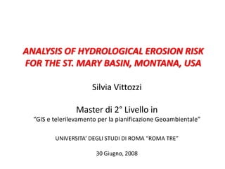
  • 1. ANALYSIS OF HYDROLOGICAL EROSION RISK FOR THE ST. MARY BASIN, MONTANA, USA Silvia Vittozzi Master di 2° Livello in “GIS e telerilevamento per la pianificazione Geoambientale” UNIVERSITA’ DEGLI STUDI DI ROMA “ROMA TRE” 30 Giugno, 2008
  • 2. THE PURPOSE OF RESEARCH IS TO ESTIMATE THE MOST EXPOSED AREAS TO SOIL EROSION IN THE UPPER ST. MARY BASIN, MONTANA, USA 12/10/2009 2
  • 3. WATERTON-GLACIER INTERNATIONAL PEACE PARK Source: www.wikipedia.org 3
  • 4. Hydrology Saskatchewan River watershed. Source:www.wikipedia.org St. Mary River Km 200 Oldman River Km 362 South Saskatchewan Km 1,392 kilometers Upper Old Man River watershed; in the South of the map, the affluent St. Mary river. Source: www.uoguelph.ca 12/10/2009 4
  • 5. THE SOIL Isbasicforall life’s form. Encloseselements: biological mineral Is a naturalresource itneed long timetobecreated (geologicalages!) Itneedtobeconserved 12/10/2009 5
  • 6. Soilerosionby water RAINFALL causesrills and sheeterosion Fonte: Marco AcutisDiProVe, marco.acutis@unimi.it, www.acutis.it 12/10/2009 6
  • 7. SOIL LOSS CAUSED BY WATER Depend on: amount and intensity of rainfall and runoff. land cover which reduce the direct forces of rainfall susceptibility to erosion (texture, composition,…) topography of the landscape as described by slope length, steepness and shape. Artificial conservation practices (terracing, canalizations) and land use. THE GIS IS A POWERFUL TOOL WHICH CAN MANAGE TOGETHER ALL THESE ELEMENTS 12/10/2009 7
  • 8. DEM resolution 10 m Fonte : USGS 12/10/2009 8
  • 9. Mosaic of Natural-Color Aerial Photos, 2005These photos are in MrSID format and Montana State Plane coordinates, units meters, datum NAD83. Source: U.S. Farm Services Agency National Agricultural Imagery Program (NAIP). 12/10/2009 9
  • 10. 20 % Subalpine fir Engelmann Spruce 15 % Cliff/Talus Sparse Vegetation 16% Dwarf-shrub/Herbaceous Complex Dry - Mesic Source photos: USGS-NPS, 2007 12/10/2009 10
  • 11. USLE = UNIVERSAL SOIL LOSS EQUATION Long terms (annual) In a determinate area In this case: Upper St. Mary watersheed A standard methodtomapthe potentialrisk and erodibilityofsoil 12/10/2009 11
  • 12. USLE Itwasconceived: In USA In 1978 Wischmeier and Smith (USDA) For the field. Subsequently was applied also at not only agricoltural areas 12/10/2009 12
  • 13. USLE A = R * K * LS * C * P A = potentialmeanannualsoil loss R FACTOR = rainfallfactor K FACTOR = soilerodibilityfactor LS FACTOR = topographicfactor C FACTOR = land cover factor P FACTOR = conservationpractices (terracing) 12/10/2009 13
  • 16. THE USLE MAP It show: The Potentialerosion The areaswhere rise RILL EROSION and SHEET EROSION UNITA’ In English Units: tons /hectar/year DATUM: NAD83 12/10/2009 16
  • 17. Shape file ottenutodallaclassificazione del data set: Vegetation Map - Waterton-Glacier International Peace Park Vegetation Mapping Project. USGS-NPS 1999 Glacier National Park- 12/10/2009 17
  • 18. MEASURE UNITS Conversion of USLE factor values to U.S. customary measure units. Source: Wall et al, 2002. 12/10/2009 18
  • 19.
  • 21. PRISM Group (Parameter-elevation Regressions on Independent Slopes Model) climate mapping 12/10/2009 19
  • 22.
  • 24. LS FACTOR LUNGHEZZA DEL VERSANTE (length) È un indice espresso sulla base di una condizione standard di: 9 ° di pendenza e 22 m di lunghezza = Distanza compresa tra il punto in cui si origina lo scorrimento ed il punto in cui si ha una deposizione di materiale trasportato, per una diminuzione della pendenza. PENDENZA del versante (stepness) è espressa in GRADI Definition of slope length (Renard, et al. 1987) 12/10/2009 21
  • 25. Metodo Shulze (1995) Formula per calcolare la lunghezza: L = where: 22.1 = misura standard dellalunghezza del versante m = = esponenterelativo al rapportoerosionedaflusso e da rainfall Where: β = Where: SD = slope in degree ʎ = - 3.0S + 100 for S < 25% ʎ = 25 for S ≥ 25% where: S = slope gradient in percent 12/10/2009 22
  • 26. Metodo Shulze (1995) ʎ = A A = con (S ≥ 25,25,(5*(-3))+100) β = B3 B3 = B1/B2 B1 = sin (SD div deg) B2 = 0.0896(3*(pow(B1,0.8)) + 0.56) m = M M = B3/(1+B3) L = pow(A/22.1,M) LENGTH Formula per calcolare la lunghezza del versante: procedimento con rastercalculator: 12/10/2009 23
  • 27. Metodo Shulze (1995) St = 10.8 sin (SD div deg) + 0.03 for S < 9% St = 16.8 sin (SD div deg) – 0.50 for S ≥ 9% St = 3.0 [sin(SD div deg)]0.8 + 0.56 for slope lengths < 5m Con raster calculator: S2 = con (SD < 9,(10.8*B1) + 0.03,(16.8*B1) – 0.5) S3 = con (L < 5,(3*(pow(B1,0.8)) + 0.56,S2) STEEPNESS   Dopodichèsicalcolal’indice del fattoretopograficomoltiplicando la lunghezza per la pendenza del versante: LS = S3 * L SL FACTOR Formula per calcolare la pendenza del versante secondo queste condizioni: 12/10/2009 24
  • 28. DATA SOURCES Landuse USGS-NPS 1999 Glacier National Park Vegetation Map - Waterton-Glacier International Peace Park Vegetation Mapping Project. Shape file, NAD 83 . 12/10/2009 25
  • 29.
  • 30. Altezza di cadutaPercentuale di suolo ricoperto dalla canopy 12/10/2009 26
  • 32. C-factor for permanent pasture and woodland Source: Wischmeier and Smith, 1978. 12/10/2009 28
  • 33. C Factor per territoriallostatonaturale e foreste Source: Wischmeier and Smith, 1978. 12/10/2009 29