The Mystery of Malaysian Airlines MH370
•
2 gostaram•637 visualizações

Everything you wanted to know about MH370 and its mysterious disappearance...

Recomendados
Mais conteúdo relacionado
Mais de Prayukth K V
Mais de Prayukth K V (20)
Último
Último (20)
The Mystery of Malaysian Airlines MH370
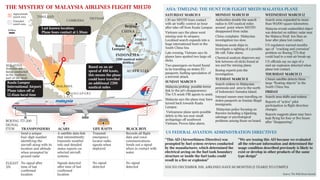
- 1. 100km Approximate search area Extended search area THAILAND CAMBODIA VIETNAM MALAYSIA MALAYSIA Searches are being conducted in the northern part of the strait Source: The Wall Street Journal ASIA: TIMELINE: THE HUNT FOR FLIGHT MH370 MALAYSIA PLANE US FEDERAL AVIATION ADMINISTRATION DIRECTIVES THE MYSTERY OF MALAYSIA AIRLINES FLIGHT MH370 SATURDAY MARCH 8 1.30 am MH370 loses contact with air traffic control an hour after take-off from Kuala Lumpur. Vietnam says the plane went missing near its airspace. Localised search expands into a huge international hunt in the South China Sea. Late evening, Vietnam says its planes have spotted two large oil slicks. Two passengers on board found to be travelling on stolen EU passports, fuelling speculation of a terrorist attack. SUNDAY MARCH 9 Malaysia probing possible terror link to the jet's disappearance. The US sends FBI agents to assist. Malaysia says the plane may have turned back towards Kuala Lumpur. Vietnamese plane spots possible debris in the sea near small archipelago off southwest Vietnam. Proves false alarm. MONDAY MARCH 10 Authorities double the search radius to 100 nautical miles around point where MH370 disappeared from radar. China complains Malaysian investigation too slow. Malaysia sends ships to investigate a sighting of a possible life raft. False alarm. Chemical analysis disproves any link between oil slicks found at sea and the missing plane. Boeing experts join the investigation. TUESDAY MARCH 11 Search widens to Malaysian peninsula and area to the north of Indonesia's Sumatra island. Interpol names men travelling on stolen passports as Iranian illegal immigrants. Malaysian police focusing on theories including a hijacking, sabotage or psychological problems among those on board. WEDNESDAY MARCH 12 Search zone expanded to more than 90,000 square kilometres. Malaysia reveals unidentified object was detected on military radar near the Malacca Strait less than an hour after plane lost contact. US regulators warned months ago of “cracking and corrosion” problem on Boeing 777s that could lead to a mid-air break-up. US officials say no sign of a mid-air explosion detected when plane lost contact. THURSDAY MARCH 13 China’s satellite detects three large “floating objects” in the South China Sea. FRIDAY Search area shifts and widens. Reports of “active” pilot participation in flight direction changes. Reports suggests plane may have kept flying for four or five hours after “disappearing”.BOEING 777-200 Beijing Kuala Lumpur INDONESIA 2200 nautical miles2200 nautical miles 4048km4048km CHINA AUSTRALIA SIGNAL ITEM FLIGHT 370 TRANSPONDERS Send a unique four-digit number identifying the aircraft along with its location and altitude when prompted by ground radar No signal after time of last confirmed location ACARS A satellite data link that intermittently transmits weather info and detailed status reports on selected aircraft systems Signals detected after time of last confirmed location LIFE RAFTS Transmit emergency locator radio signals when deployed No signal detected BLACK BOX Records all flight data and voice communications. Sends out a signal when in contact with water. No signal detected “This AD (Airworthiness Directive) was prompted by fuel system reviews conducted by the manufacturer, which determined the electrical arcing on the fuel tank boundary structure or inside the fuel tanks could result in a fire or explosion” “We are issuing this AD because we evaluated all the relevant information and determined the usage condition described previously is likely to exist or develop in other products of the same type design” ISSUED DECEMBER 2011, AIRLINES HAVE 60 MONTHS (5 YEARS) TO COMPLY SI NGA POR E Kuala Lumpur International Airport: Plane takes off at 12.41am local time Last known location: Plane loses contact at 1.30am Strait of M alacca Strait of M alacca Based on an air speed of 480 knots, this means the plane could have travelled an additional 2200 nautical miles Intended route