SlideShare uma empresa Scribd logo
1 de 43
REGION 8
EASTERN VISAYAS
HISTORY OF REGION VIII EASTERN VISAYAS
Eastern Visayas is one of the two regions of the Philippines having no
land border with another region, MIMAROPA being the other, and is designated
as Region VIII. It has six provinces: Biliran, Eastern Samar, Leyte, Northern
Samar, Samar and Southern Leyte are some of the poorest provinces in the
country. The economy is deeply agricultural their farming practices in some parts
of the region date back to the early 1800's. Agricultural development has been
slow and highly selective to few pockets of more enterprising (and well-off)
farmers because of the typically rugged interior of the two main islands,
agriculture has been limited to mostly the coastal areas and small inland valleys.
Heavy industry has been confined to a small industrial zone on the northwest of
Leyte Island much of the hinterlands, especially in Samar, is now heavily forested
having had a chance to recuperate from the devastating logging operations in the
1970's and 1980's. It was Samar and Leyte which the renowned Portuguese
explorer Ferdinand Magellan first saw and landed on after his long voyage
across the Pacific in 1521.The first Christians in Southeast Asia were the people
of Limasawa where the first mass was held. Five centuries later, General
Douglas MacArthur led the Allies to victory in the Battle of Leyte wherein the
ensuing naval battle, now known as the Battle of Leyte Gulf.Leyte became the
secure foothold of the Allies in conquering back the archipelago, and eventually
the rest of Asia, from the Japanese.
GEOGRAPHICAL CONTEXT
Eastern Visayas lies on the east central part of the Philippine
archipelago. It is composed of two main islands, Leyte and Samar, which formed
the eastern most coast of the archipelago. It is bounded by the Philippine sea on
the east and north with San Bernardo Strait separating Samar island from
southeastern Luzon: Camotes sea and Visayas sea on the west: Bohol sea on
the south with Surigao Strait separating Leyte island from northwestern
Mindanao. It has a total land area of 2,156,285 hectares or 7.2% of the
country’s total land area. 52% of its total land areas are classified as forestland
and 48% as alienable and disposable land.
POLITICAL DIVISIONS
Officially known as Region VIII, Eastern Visayas has 6 provinces, 12 districts, 7
cities, 136 municipalities, and 4,390 barangays.
 Biliran (capital Naval): lone district, 8 municipalities, 132 barangays
 Eastern Samar (capital Borongan City): lone district, 22 municipalities, 1
city, 597 barangays
 Leyte (capital Tacloban City): 5 districts, 40 municipalities, 3 cities,
1,641 barangays
 Northern Samar (capital Catarman): 2 districts, 24 municipalities, 569
barangays
 Samar (formerly Western Samar) (capital Catbalogan City): 2 districts,
24 municipalities, 2 cities, 951 barangays
 Southern Leyte (capital Maasin City): lone district, 18 municipalities, 1
city, 500 barangays
DEMOGRAPHICS
Population census of Eastern Visayas
Year Total population
1990 3,054,490
2000 3,610,355
2007 3,912,936
2010 4,101,322
2013 3,880,148
CLIMATE
There are two types of climate prevailing in the region under the Corona
system of classification: Type II and Type IV. Type II climate is characterized by
having no dry season but a pronounced maximum rainfall from November to
January. Samar Island and the eastern part of Leyte Island fall under this type of
climate. Type IV on the other hand has an even distribution of rainfall the year
round and a short period of dry season that can be observed starting February
up to May. This type of climate is well exhibited at the western half of Leyte
island and some portion of Samar which covers the municipality of Motiong up to
San Isidro of Northern Samar. The eastern portion of the region is frequently
visited by storms from the Pacific Ocean. The region receives heavy rainfall
throughout the year with no pronounced dry season.
In November 2013, the region was hit with the highest death toll in the
country by Typhoon Haiyan, the second deadliest typhoon ever to hit the
Philippines.
NATURAL RESOURCES
The region's sea and inland waters are rich sources of salt and fresh water
fish and other marine products. It is one of the fish exporting regions of the
country. There are substantial forest reserves in the interiors of the islands. Its
mineral deposits include chromite, uranium, gold, silver, manganese,
magnesium, bronze, nickel, clay, coal, limestone, pyrite and sand and gravel. It
has abundant geothermal energy and water resources to support the needs of
medium and heavy industries.
CHROMITE BRONZE
MAGNESIUM
SILVER LIMESTONE NICKEL
CHARCOAL
CLAY
URANIUM
ECONOMY
The Department of Agriculture's 2011 report said agriculture, fishery and
forestry accounted for 20.49% of the regional economy.
In that year, palay and coconut were the leading commodities to
agricultural production of Eastern Visayas. The region was 7th in palay
production and 2nd in coconut production.
The agricultural land area in Eastern Visayas covers 723,048 hectares, or
31% of the region's total land area of 2,325,395 hectares.
In the agency's September report, low volume of fish catch and limited
supply of fishery products were noted due to expensive fishing trips and rough
seas.
LAND USE
Eastern Visayas is primarily an agricultural region with rice, abaca, corn,
coconut, sugarcane and banana as major crops. Its total land area is 21,431.7
sq. kms. 52% of its total land area is classified as forestland and 48% as
alienable and disposable land.
CULTURE AND BELIEFS
Cultural groups
Region VIII is inhabited by the Waray-Warays, the country’s fourth largest
cultural linguistic group. Cebuanos from the nearby island of Cebu live in Ormoc
City, Western Leyte and parts of the Southwest of Leyte.
Languages
Waray-Waray is the lingua franca of the Eastern Visayas Region and
mostly spoken on the island of Samar, Biliran, Tacloban and north-eastern Leyte.
A Samar language, distantly related to the languages of the region, called
Abaknon is spoken in the island of Capul in Northern Samar. Cebuano is spoken
in western, central, and southern parts of Leyte and in Southern Leyte. Other
languages spoken in Eastern Visayas are Baybayanon, which is spoken in
Baybay with 10,000 speakers and Kinabalian, which is spoken in the municipality
of San Juan, Southern Leyte.
Dances
Tinikling, the Philippines' national dance is folkdance that originated from
the region. But the most popular cultural dance among Warays is the Kuratsa,
danced during feast celebrations and special gatherings. The Leyte Kalipayan
Dance Company, a local cultural group, held highly successful performances
around the world.
Tinikling Kuratsa
Music
Waray people are music lovers whose folkloric music are mostly ballads in
form, famous of which is "Dandansoy" while "Iroy nga Tuna" (Motherland) is a
patriotic song.
1. History of Eastern Samar,Philippines
(The Land of Good Harbors)
This article from the LGU of Eastern Samar Province
Eastern Samar became an independent province by virtue of Republic Act
No. 4221 which Congress approved on June 19, 1965 dividing the then existing
old province of Samar into three separate provinces, namely; Northern Samar,
Western Samar (subsequently renamed Samar) and Eastern Samar. A
plebiscite held simultaneously with the November 1965 general elections upheld
the conversion of Eastern Samar into a separate province.
In 1967 the newly created province elected its first set of officials and on
January 2, 1968, the provincial board had its inaugural session in the Borongan
Town Hall which served as the temporary
provincial capital. Eight months later, the
formal inauguration of the new province of
Eastern Samar took place.Before its
existence as an independent province,
places which now form part of Eastern
Samar played important roles in the
history of our country.
It was in Eastern Samar where
Ferdinand Magellan landed in Homonhon
Island in the town of Guiuan on March 16,
1521, in what is now officially recognized
as the discovery of the Philippines by the
Western World. Magellan called the place Zamal.Sustained contact with Western
civilization occurred as early as 1596. Jesuit missionaries worked their way from
the western coast of the island of Samar and established mission centers in what
is now Eastern Samar territory.
On September 28, 1901, Filipino rebels in the town of Balangiga attacked
and almost wiped out American troops billeted in the municipal building and
church convent. Now known in history books as the “Balangiga Massacre Day,"
the incident triggered a ruthless pacification campaign by US forces aimed at
turning the entire island of Samar into a "howling wilderness." It was during this
campaign that American soldiers took the Balangiga Bells from the Balangiga
church as war trophies. The bells remain on display at Warren Air Force Base in
Cheyenne, Wyoming.
On October 17, 1944, US Army rangers landed on the island of Suluan in
Guiuan where they fought their first battle on Philippine territory three days
before Gen. Douglas MacArthur stormed the beaches of Leyte.
Eastern Samar was the first area of the Philippines sighted by Magellan
on March 16, 1521. The lofty mountains of Zamal as called by Magellan’s crew
are the mountain ranges that separate the province from Western Samar and
Northern Samar. The Spaniards, however, anchored at the tiny island of
Homonhon on the southern side of the province. During the early days of
Spanish rule, the Province of Samar, (of which Eastern Samar was a part) was
called “Ibabao”. It was under the political and ecclesiastical jurisdiction of Cebu.
Samar was made a separate province from Cebu in 1768. From its capital,
Catbalogan, the administration of the encomiendas in the eastern coast was
controlled. Samar was divided into three provinces, namely: Eastern Samar,
Northern Samar and Western Samar, by virtue of Republic Act No. 4221. The
Law was overwhelmingly ratified in a plebiscite on November 9, 1965.
GEOGRAPHICAL CONTEXT
There are three provinces located in the Island of Samar: Western Samar,
Eastern Samar and Northern Samar. Eastern Samar is located in Eastern
Visayas within Region VIII, 11.6667° N, 125.5000° E - Eastern Samar,
Coordinates. Eastern Samar has 4,640 square km area.
DEMOGRAPHIC
Eastern Samar Population (as of 2010 census) = 428,877
Eastern Samar Population (as of Aug 1, 2007 census) = 405,114
HOTSPOT AREAS IN EASTERN SAMAR
Small tropical haven in Eastern Samar,
whether it’s the creamy sands and azure
waters of Suluan Island or the marine life
sanctuary of Kantican Island, which also
houses an experimental pearl farm.
Amandaraga is the name of Lawaan’s
waterfalls which resembles a maiden’s hair.
Favorite island hopping destinations are the twin
islands of Ando and Divinuvo in Borongan City.
For camping and trekking, explore the Borongan-
Llorente Closed Canopy Forest.
The ultimate crowd-drawer, however, is the rising star that is Calicoan
Island. Despite the allure of its inland lagoons and wild virgin forests, both locals
and foreigners head here for one thing: surfing. The ABCD Beach, the shoreline
of choice if you’re staying at The Surf Camp or the Calicoan Villas, offers
waves suitable for both beginner and advanced surfers. The local surf season
runs from April to November.
Eastern Samar is sprinkled with locations
that have hosted some of the country’s most
interesting historical events.
Homonhon Island was where Magellan
first set foot on Philippine soil in 1521. Tubabao
Island sheltered thousands of Russian refugees
in the 1950s; the refugees were survivors of the
Bolshevik Russian Revolution and Russian Civil
War. And the modest town of Balangiga was the
site of a noteworthy chapter in Philippine history
— a powerful story involving resistance, revenge
and church bells.
The province also hosts the Padulong
Festival every September, an energetic and grand
socio-cultural celebration filled with colourful
parades and street dancing.
FESTIVALS IN EASTERN SAMAR
March 16 (Karapayan Festival, Blessed Virgin Mother) – A colorful festival
depicting how the early Guiuan Townsfolk enjoyed nature’s bounties, rich marine
life, fertile land, verdant forest. It is also a thanksgiving to their Patroness, the
Blessed Virgin Mother.
 May 1 (St. Francis of Assisi) – Mercedes May 8 (The Divine Child) –
Lawa-an
 May 15 (St. Isidore the Farmer) – Salcedo
 May 27 (St. Isidore the Farmer) – Maslog
 June 13 (St, Anthony of Padua) – Llorente
 July 15 (Our Lady of the Seven Sorrows) – San Julian
 July 22 (St. Mary Magdalene) – San Policarpo
 July 25 (St. James the Greater) – Taft
 July 30-31 (St. Ignatius of Loyola) – Sulat
 August 1-2 (Our Lady, Queen of Angels) – Can-avid
 August 10 (St. Lawrence of Rome) – Balangiga
 August 16 (St. Roche) – Maydolong
 August 16 (St. Joachim) – Dolores
 August 27 (St. Joseph) – Gen. MacArthur
 August 31 (St. Raymond Nonnatus) – Arteche
 September 8 (The Nativity of Our Lady) – Borongan
 September 10 (St. Nicholas of Tolentino) – Quinapundan
 September 15 (Our Lady of Seven Sorrows) – Hernani
 October 7 (Our Lady of the Holy Rosary) – Jipapad
 October 12 (Our Lady of the Pillar) – Giporlos
 October 19 (St. Peter of Alcantara) – Oras
 December 8 (Our Lady of the Immaculate Conception) – Guiuan
COMMON PRODUCTS
PRODUCT : Squash Cookies
PRODUCER: San Mateo ARB MPCZ
ADDRESS: DR Provincial Office,
Borongan Easter Samar
CONTACT PERSON/S : Conrado
Amano
CULTURE AND BELIEFS
 Religion
The people of the province are devoted Christians where 96% adhere to
Roman Catholicism. The dominant Catholic faith influences the events of
the provincial education, politics and social functions of the people. Other
Christians usually form the remaining groups of believers such as
Jehovah's Witnesses, Iglesia Ni Cristo, Baptists, Methodists, Church of
Christ of Latter Day Saints Seventh-day Adventist. Non- Christians (mostly
Muslims) are also found.
2. HISTORY OF LEYTE
(Mahaba Island:An UnderwaterParadise)
Leyte has a colorful history. Leyte like the Samar when it comes to their
province, point out of that their forebear were among the first to welcome the
Spaniards but they were also among the first to resist the invaders. Leyte was
one of the provinces where the early seeds of nationalism were planted.
In 1521, Magellan sailed from the island of Homonhon, Samar to the
island of Limasawa, Leyte, entered into a blood compact with Rajah Kolambu.
On Eastern Sunday, March 31, of that year, was celebrated the First Mass in the
Philippines. Some historical researchers, however, are now
disputing this.
The next century witnessed a religious uprising lead by
Bancao, the Limasawa chief, and his high priest, Pagail. The
revolt began in Carigara and spread to neighboring towns
before it was quelled. 27 years after the 1622 uprising, another
revolt hit Leyte - an offshoot of the Sumoroy rebellion then
simmering in Samar. And in the center of the disturbances, the
village of Bacor, rebels burned the church and its convent.
By 1768, Leyte, now separated from Samar, became a politico-military
province. The set up continued until the end of Spanish rule, when Gen. Vicente
Lukban took over Leyte and Samar in the name of the Revolutionary
Government. It was World War II, however, which placed Leyte on the world
map. On October 20, 1944, Gen. Mac Arthur, at the head of the largest US fleet
of transport and warships, and accompanied by Commonwealth President Sergio
Osmeña and Gen Carlos P. Romulo, landed on Palo, Leyte to reclaim the
Philippines from the Japanese. On May 22, 1959, the province was divided into
Leyte and southern Leyte. Information provided by the Department of Tourism of
Government of the Philippines.
GEOGRAPHICAL CONTEXT
Leyte is an island province located within Region VIII- Eastern Visayas
10.8333° N, 124.8333° E - Leyte, Coordinates. Leyte has 6,515 square km area.
DEMOGRAPHIC
Leyte Population (as of Aug 1, 2007) = 1,722,036
Leyte Registered Voters (2009) = 908,480
Leyte population (as of year 2010) = 1,567,984
HOTSPOT AREAS IN LEYTE
An American general famously promised he
would return here. After one visit, so will you. Leyte
is home to two of the most famous events in
Philippine history. First, the Battle of Leyte Gulf is
the largest naval battle of World War II. It took place
from 23-26 October 1944 between combined US
and Australian forces and the Imperial Japanese
Navy.
Second, a promise that involves Gen.
Douglas MacArthur and Red Beach in Palo is a
site known more for its history than its shoreline.
Allied Forces led by Gen. Douglas MacArthur
returned here on 20 October 1944 to aid the
Philippines against the Japanese invasion,
fulfilling his oft-quoted promise, “I shall return.”
That moment is commemorated by the Leyte
Landing Memorial that stands at Red Beach
today.
Apart from its historical sites, Leyte is
also a good jump-off point to find some isolated
isles that look straight out of the pages of a travel
magazine. Kalanggaman Island in Palompon
is the quintessential tropical island, where
gradient blue waters lap peacefully at fine sugary
sand. Cuatro Islas (“Four Islands”) in Inopacan
and Hindang are another pretty bunch. Of these
islands, Digyo is a standout: palm trees, clear
waters, and barely any other tourists in sight.
Snorkel in its shimmering waters to swim amongst
corals and fish.
Another great place for swimming,
snorkeling, kayaking and camping can be found in
Canigao Island off the municipality of Matalom. Its assets are beautiful white
sand and crystal clear waters. Tanauan is the birthplace of skimboarding in the
Philippines and host to annual national skimboarding competitions. The
Mahagnao Volcano Natural Park may also trek and picnic surrounded by lush
foliage, visit hot springs, take a boat ride across a lake, or trek to volcanic
craters.
Local specialties in Leyte are the two of
the most popular are binagol, a mix of talyan (a
local root crop), coconut milk, and sugar steamed
inside coconut shells; and moron, glutinous rice
cooked in coconut
milk and flavored
with cocoa. Other
favorite native delicacies are the pastillas de
leche, made from pure cow’s milk and roscas,
traditional rusk bread especially baked by the
women of Barugo. It is made from egg yolk, wheat
flour, milk, shortening, and flavored with anise
seeds.
FESTIVALS IN LEYTE
August 29 (Buyog-Buyogan, St. Francis Xavier) – Abuyog "Buyog" (bees)
dancers, depict the origin of the town's name in a well choreographers dance
August 14-15 (Pasaka Festival, Our Lady of Assumption) – Tanauan Leyte,
Legend has it that Tanauanons witnessed the assumption of Blessed Mother into
Heaven. After seeing this great Miracle, they rejoiced and celebrated the event
with dances.
 January 15 (Sinulog, Holy Child) – Isabel
 January 15 (Holy Child) – Tabango
 January 25 (Sto. Niño Hiyas ka sa Bato, Holy Child) – Bato
 Second Saturday of February (Sinulog, Holy Child) – Villaba
 April 28 (Viajedores) - La Paz
 May 3 (Pamagpagan, St. Francis of Assisi) – Pastrana
 Second Saturday of May (Tambula Festival, St. Vincent Ferrer) –
Babatngon
 May 8 (Sangkaan, St. Michael the Archangel) – Hindang
 May 8 (Tolo-usa, St. Michael the Archangel) – Tolosa
 May 11 (Pahoy-Pahoy Festival, St. Joseph) – Barugo
 May 13 (Our Lady of Fatima) – Ormoc City
 May 15 (St. Isidore the Farmer) – Inopacan
 May 15 (St. Isidore the Farmer) – MacArthur
 May 15 (St. Isidore the Farmer) – Merida
 May 15 (Sinulog, St. Isidore the Farmer) - San Isidro
 May 18-19 (Sanggutan Festival) – Barugo
 May 27 (Dinagamihan, St. Joseph) – Dagami
 May 27 (St. Joseph) – Matalom
 May 28 (Karayhakan, St. Michael the Archangel) – Javier
 June 5 (Minoro, Holy Name of Jesus) – Capoocan
 June 11-12 (St. Anthony of Padua) – Matag-ob
 June 13 (Lukayan, St. Anthony of Padua) – Mayorga
 June 13 (St. Anthony of Padua) – Tunga
 June 13 (St. Anthony of Padua) – Tabon-Tabon
 June 19 (Lingganay Festival, Holy Trinity) – Alang-Alang
 June 28-29 (Piñahan, Sts. Peter and Paul) – Ormoc City
 July 16 (Makabugwas, Triumph of the Holy Cross) – Carigara
 July 25 (Caballero, St. James the Great) – Albuera
 July 26 (Pamilipig, St. Anne) - Sta. Fe
 June 30 (Pintados de Leyte Festival, Holy Child) - Tacloban City
 August 8 (Tribung Bagong Silang, Transfiguration of Our Lord) – Palo
 August 11-12 (Hulatan Festival, St. Roche) – Julita
 August 15-16 (Lubi-Lubi Festival, Our Lady of Fatima and St. Roche) –
Calubian
 September 8 (Karatong, Our Lady of Refuge) – Dulag
 September 21 (Tambalan, St. Matthew the Apostle and Evangelist) – Jaro
 September 28 (St. Michael the Archangel) – Javier
 September 29 (Bathan Festival, St. Michael the Archangel) - San Miguel
 September 28-29 (Kaplag Festival, St. Michael the Archangel) – Mahaplag
 October 20 (city charter day) – Ormoc City
 October 20 (Leyte Landing Anniversary) – Palo
 December 3 (St. Francis Xavier) – Palompon
 December 8 (Karu-Katik, Festival, Our Lady of the Immaculate
Conception) – Burauen
 December 8 (Hiraite, Our Lady of the Immaculate Conception) – Leyte
 December 27 (Sidong Festival, Our Lady of the Immaculate Conception) –
Baybay City
 December 30 (Kan-anga Festival) – Kananga
 December 31 (Alikaraw Festival, Our Lady of the Immaculate Conception)
– Hilongos
 Black Saturday (Torugpo) – Carigar
 Easter Sunday (Sunduan Ha Carigara) – Carigara
COMMON PRODUCTS
LEYTE
PRODUCT: BINAGOL
PRODUCER: TERRY’S
CULTURE AND BELIEFS
 Languages/dialects
"Waray" is generally spoken by the people of Leyte except those who live
in the western side who generally speak Cebuano
3. History of Northern Samar,Philippines
(Hidden Paradise of Visayas)
The province of Northern Samar was created by Republic Act No. 4221 which
was approved by Congress on June 19, 1965 dividing the whole island of Samar
into three independent provinces namely; Northern Samar, Western Samar
(subsequently renamed Samar) and Eastern
Samar. As embodied in this Act, the eastern
province is composed of 24 municipalities
with Borongan as the capital.
The province is located in the eastern
part of the Philippine Archipelago, bounded
on the north by the San Bernardino Strait, on
the east by the Pacific Ocean, on the west by
the Samar Sea, and on the south by Samar.
It is composed of 24 municipalities and 569
barangays covering a total land area of
3,692.9 square kilometers. Catarman is the provincial capital and center of trade
and commerce.
Northern Samar is strategically located as the gateway to Visayas and
Mindanao from Luzon. It is 743 kilometers from Manila and can be reached by 1
hour and 20 minutes plane ride to Catarman or 14 hours bus travel through the
Pan Philippine Highway passing Bicol Region and traversing San Bernardino
Strait via ferry boat in the primary ports of San Isidro and Allen, from Matnog,
Sorsogon. The route to Mindanao is through Tacloban City, being connected to
Northern Samar by the famous San Juanico Bridge, via ferryboat in Liloan,
Southern Leyte to Surigao. Majority speak Waray dialect, along with Inabaknon,
which is predominantly spoken in Capul Island.
The province is endowed with metallic minerals such as copper, aluminum
and bauxite which can be found particulary in Biri, Mapanas and San Isidro.
Major agricultural crops include coconut, abaca, palay, rootcrops and other
subsistence crops. Its rich fishing grounds produce spanish mackerel, grouper,
tuna, big-eyed scad, round scad, herring, anchovies and salmon. Other aquatic
products include cattlefish, crabs, shrimps, squid and lobsters.
Northern Samar is famous for its natural rock formations found in Biri
Island and white silky sand beaches in San Jose and Lavezares. A visit to the
century old church in Capul Island brings you to the 16th century. Only
missionary fervour made possible the building of this church on this island.
GEOGRAPHICAL CONTEXT
There are three provinces located in the Island of Samar: Western Samar,
Eastern Samar and Northern Samar. Northern Samar is located in the
northernmost portion of Samar, the third largest island of the country. It is 732.72
kilometers southeast of Manila. The Pacific Ocean bound Northern Samar on the
east, the San Bernardino Strait on the north, the Samar Sea on the west and
Samar on the south. 12.3333° N, 124.6667° E - Northern Samar, Coordinates.
Northern Samar has 3,692 square km area.
DEMOGRAPHIC
In the 2007 Census of Population, the province registered a total
population of 549,759, posting an average annual growth rate of 1.3 percent. Its
population density is recorded at 149 persons per square kilometer. Population:
589,013 (2010)
HOTSPOT AREAS IN NORTHERN SAMAR
Lying to the north (of the South) are the rural province of Northern Samar
and its capital, Catarman. The towns are small and sleepy; the landscapes
sometimes more unruly than picture-perfect. But
this often-overlooked province holds some
unbelievable surprises. For starters, beaches are
plentiful here. Stay at one of the local resorts to
enjoy a stretch of sand to yourself and savor cold
drinks and good conversation under the
moonlight.
Pick from the honey-colored shores of Onay Beach in Laoang and or the
sparkling white sands in San Antonio Island, Dalupiri Island, or Spice of Life.
For somewhere off the beaten path, explore the Naranjo group of islands such as
Sila Island with its pinkish sand and Panganoron Island with white sand.
Located close to the National Highway is the municipality of Victoria that
serves as the jump-off point to San Antonio Island. The 280-meter steel bridge
passing through Mawo River serves as its landmark. The coast here is lined with
beautiful beaches have mountains as their back drop. Caves, springs, waterfalls
and rivers are accessible too.
Allen is the municipality that connects
Luzon to Northern Samar via the RORO (roll on
– roll off) boats. In here you’ll find Felixville
Resort, Wayang-Wayang Beach Resort, and
Paradise Beach which are all budget-friendly
and definitely good for big groups.
Capul Island also has its share of white
beaches and snorkelling spots. It gets its name from Acapulco in Mexico, owing
to its former life as a guidepost for galleons sailing trade routes between
Acapulco and Manila.
Go beyond the beach and explore the island’s historical structures, which
date back to the late 1800s: the Capul Island Lighthouse, Capul Church and
Fortress, and the Batag Island Lighthouse.For bird
watching, the Lalaguna Mangrove Forest in
Lavezareshosts different migratory birds. It’s best if
you ride a paddle boat here to get closer to nature.
It’s Biri Island, however, that really amps up
Northern Samar’s wow factor. Forget food and
drinks,what you absolutely shouldn’t forget to pack
is your camera. Stunning rock formations — monstrous cliffs, boulders and crags
naturally carved by the ocean waves and winds — make for views that will bring
out the photographer in anyone.
FESTIVALS IN NORTHERN SAMAR
Second Week of January (Embajada) – Catubig
A festivity practiced by the People of Catarman since 1922, featuring a re-
enactment of how the Filipino natives were christianized by the Spanish
Conquistadores. It was officially made into a provincial festival in 1992.
 Last Sunday of January (Sakay-Sakay Fluvial Procession) – Laoang
 March 16 (Parayan Harvest Festival) – San Roque
 April 29 (St. Vincent Ferrer) – San Vicente
 May 14-15 (St. Isidore the Farmer) – Lope de Vega
 May 14-15 (St. Isidore the Farmer) – Silvino Lobos
 May 14-15 (St. Isidore the Farmer) – San Isidro
 Second Week of June (Bangkules Festival) – Palapag
 June 11-12 (Manoglaya Festival, St. Anthony of Padua) – San Antonio
 June 11-12 (St. Anthony of Padua) – Mondragon
 June 19 (Embajada Festival) – Catarman
 June 24 (St. John the Baptist) – Pambujan
 June 24-25 (St. James the Greater) – Allen
 June 24-25 (St. Vincent Ferrer) – Biri
 July 13-14 (St. Bonaventure) – Lapinig
 July 18-19 (Our Lady of the Angel) – Mapanas
 July 26-27 (St. Joseph the Worker) – Catubig
 July 28-29 (St. Anthony of Padua) – San Jose
 July 30-31 (St. Ignatius of Loyola) – Capul
 August 5-7 (St. Anne) – Victoria
 August 9-10 (Ati-Atihan Festival, Most Holy Name of Jesus) – Bobon
 August 14-15 (Our Lady of the Assumption) – Palapag
 August 15-16 (St. Roche) – San Roque
 August 21-22 (Our Lady of Salvation) – Lavezares
 August 28-29 (Our Lady of the Annunciation) – Catarman
 September 7-8 (Our Lady of the Nativity) – Las Navas
 September 14-15 (St. Michael the Archangel) – Gamay
 September 28-29 (St. Michael the Archangel) – Laoang
 October 6-7 (Our Lady of the Holy Rosary) – Rosario
COMMON PRODUCTS
PRODUCT: Coconut Groove Coco
Vinegar
PRODUCER:Galutan Primary MPC
ADDRESS:Barangay Galutan,
Catarman, Northern Samar
CONTACT PERSON/S:Emma
Humamil
CULTURE AND BELIEFS
 Religions
The communities of this province are predominantly Catholic (95%).
Other religious groups are Members Church of God International (Ang
Dating Daan), Iglesia ni Cristo, Philippine Independent Church
(Aglipayan), Seventh-Day Adventists, Jehovah’s Witnesses, Church of
Jesus Christ of Latter-Day Saints and other Christian sects. A small
number of population are Muslim.
 Languages
Majority of the people in the province of Northern Samar speak
the Ninorte Samarnon, a variation of Waray-Waray. About 4.5 percent of
the population, especially in the island towns, speak Cebuano, while a
minority speaks Inabaknon, a unique language said to be one of the most
preserved languages to date. This is the native tongue of the populace in
the island town of Capul.
Ninorte Samarnon usually is further subclassified into Balicuatro, Central
and Pacific speakers.
Tagalog, Bicol, and English are also widely used and understood in
Northern Samar.
4. History of Samar, Philippines
(Splendor Between Mountain and Sea/ Share in Nature’s Beauty)
Prior to the approval of Republic Act No. 4221 on June 19, 1965, Samar
province comprised the whole island of Samar. Under this act, the western
portion was created as a separate province named Western Samar. A
subsequent legislation (Republic Act No.
5650) however, changed the name of
the province of Samar on June 21, 1969.
The Jesuit missionaries founded
Samar in 1596. They introduced the
Roman Catholic faith to the people of
Samar. When the Jesuits left Samar in
1768, the Spanish Franciscans took over
the administration.
The former names given to Samar
were Zamal, Ibabao, Achan and
Tandaya. Legend stated that when the
Spaniards first set foot in Homonhon,
they met a wounded native from whom they asked the name of the place. The
wounded man did not understand Spanish. He thought they were asking what
happened to him and he replied "samad" meaning wound in the local dialect. So,
the navigators adopted the name for the island with a slight alteration of the last
letter, from Samad to Samar.
During the early days of Spanish occupation in the Philippines, Samar was
under the jurisdiction of Cebu. Later, it was declared a separate province, but in
1735, Samar and Leyte were united into one province with Carigara, in Leyte, as
the capital. The union, however, did not prove satisfactory. So, in 1968, Samar
has emerged as an independent political unit with Catbalogan as its capital.
On January 1900, the Americans captured the town of Catbalogan. Civil
governments were established on June 17, 1902 and Julio Llorente was
appointed as the first governor of Samar.During the administration of Governor
Baltazar Avelino, Samar was converted into a first class "A" province. Calbayog
City became a chartered city on July 16 by virtue of Republic Act no. 328.
GEOGRAPHICAL CONTEXT
There are three provinces located in the Island of Samar: Western Samar,
Eastern Samar and Northern Samar.Samar Province is 802 kilometers from
Manila. It lies southeast of Luzon and occupies the westernmost section of the
Samar Island in the visayas islands within Region VIII. To the north, it is bounded
by the province of Northern Samar; on the east by the province of Eastern
Samar; to the west by the Samar Sea and to the south by the Leyte Gulf.
Samar is connected with the province of Leyte thru Marcos Bridge on the
southwest across the San Juanico strait. 12.0000° N, 125.0000° E - Samar,
Coordinates. Samar has 6,048 square km area.
DEMOGRAPHIC
Western Samar Population (as of Aug 1, 2007 Census) = 695,149
Western Samar Registered Voters (2009 COMELEC) = 442,662
Western Samar population = (as of year 2010) 733,377
HOTSPOT AREAS IN SAMAR
On the western side of Samar Island, nature-lovers will find unusual
landscapes and a whole lot of spelunking sites. They call Samar the “Caving
Center of the Philippines”
Its most famous are the Sohoton Caves,
a two-hour trip from the town of Basey. This 840-
hectare park features limestone walls, a natural
rock bridge, underground rivers, lush forests and
caves with stunning and expansive interiors.
There’s also Langun-Gobingub Cave in
Calbiga, one of the largest karst caves in
Southeast Asia.
Swimming spots also abound.Look Beach in Calbayog City is boasting icy
blue waters facing the Samar Sea and natural rock formations that present a
more rugged beach-going experience.A ticog mat for your seaside picnics; ticog
is made with a local weed that, when woven, makes for smooth and supple mats,
tote bags, and even home
and office decors.
Take an exciting river
ride in a dug-out boat
without outriggers at the
Ulot Watershed
Ecotourism Loop in
Paranas. Be thrilled as
expert boatmen manoeuvre
the torpedo boat between
rocks up and downstream
the Ulot River. And dare to
plunge into the waters by leaping from a huge boulder.
Those in the mood for something with
more kick should check out Samar’s
waterfalls. The Bangon-Bugtong Falls
cascade elegantly into a large circular pool,
while the fun Mawacat Slide lets you zoom
down a mossy passageway into the waters
below. The Lulugayan Falls and Rapids
feature a strong and thundering current that
feeds into the Calbiga River and makes for
enjoyable white water rafting.
And while you’re here, make sure not
to bypass the quiet town of Marabut and
Daram. Marabut rewards its visitors with
islets fit for snorkelling and diving, as well as
gargantuan rock islands that artfully jut out
from the sea. Have a close encounter with
colourful fishes and rare giant clams while
snorkelling at Agutayan Island in Daram.
FESTIVALS IN SAMAR
May 25 (Pahoy-Pahoy Festival, Our Lady of the Annunciation) – Calbiga
Pahoy-Pahoy Festival is a ritual and has become part of Christian tradition
of the annual town fiesta. It is held every May 25 in Calbiga, Samar. The town of
Calbiga showcases giant pahoy-pahoy (scarecrows) made of indigenous
materials dancing in the streets to the sound of musical instruments made up of
bamboos, cans and stones that scare the maya or ricebirds. It features the
legend of Pahoy as they drive off the evil spirits and ricebirds that ruined their
rice lands and agriculture. They commemorate the time when the tribe
"humanoid" saved the village settlers from famine.
 January 15 (Daramsiyaw Festival, Holy Child) – Daram
 January 15 (Kinarawgan Festival) – Marabut
 February 22 (Holy Child) – Pagsangjan
 May 1 (St. Joseph the Worker) – Hinabangan
 May 5 (Sacred Heart of Jesus) – Almagro
 May 17 (St. Paschal Baylon) – Jiabong
 August 24 (Mangirisda and Pintados Festival, St. Bartholomew the
Apostle) – Catbalogan City
 September 1-8 (Sarakiki Festival, Our Lady of the Nativity) – Calbayog
City (Samar)
 September 28-29 (Baigan/Kawayan Festival, St. Michael the Archangel) –
Basey
 September 29 (Karabaw Festival, St. Michael the Archangel) – Gandara
 October 3 (Soleda, Our Lady of Solitude) – Calbayog City
 October 16 (Grand Caracol, St. Raphael the Archangel) – Calbayog City
COMMON PRODUCTS
PRODUCt: Tikog Mats
PRODUCER : Bulao ARB Multi-
Purpose Cooperative
ADDRESS: Barangay,Bulao,
Basey, Samar
CONTACT PERSON/S: Nestor P.
Dasig
CONTACT NUMBER/S :
(055)n2512807; (055) 2512365
CULTURE AND BELIEFS
 Religion
Samar (Western Samar) is predominantly Roman Catholic. The Catholic
Hierarchy (2014) stated that 95 percent of its population adheres to
Roman Catholicism. Some other Christian believers constitute most of the
remainder such as Born Again Christians, Iglesia Ni Cristo, Baptists,
Methodists, Jehovah's Witnesses Church of Christ of Latter Day Saints
and Seventh-day Adventist. Muslims are also present
 Language
Residents of Samar are mostly Waray, the sixth largest cultural-linguistic
group in the country. 90.2 percent of the household population speaks
the Waray-Waray language, while 9.8 percent also speak Cebuano; 8.1
percent Boholano; 0.07 percent Tagalog; and 0.5 percent other
languages.
There are two types of Waray spoken in the province, Waray Lineyte-
Samarnon which is spoken from the southernmost tip of the province up
to the municipality of Gandara and Waray Calbayog, an intermediary
between the Waray of Northern Samar and the Waray of Samar, spoken
in Calbayog City, Santa Margarita, and in some parts of Tagapul-
an, Santo Niño and Almagro.
Cebuano is spoken in some parts of the first district of Samar, mainly
in Calbayog City, Almagro, Santo Niño and Tagapul-an. English and
Chinese languages are also spoken
5. History of Southern Leyte, Philippines
(The Centuries Old Charmer)
Father of the Province of Southern Leyte : Hon. Congressman Nicanor E.
Yñiguez rough House Bill No. 1318. Legal Basis of the Creation of the Province
of southern Leyte: Republic Act No. 2227 signed by President Carlos P. Garcia
on May 22, 1959, Friday at 10:00 o’clock in the morning. Effective Date of the
Creation of the Province of Southern Leyte: July 1, 1960
Even before the fall of the Spaniards to the Americans on August 13, 1898
there had been already been established in Western Leyte a Court of First
Instance. There was the office of "Promoter Fiscal" equivalent to the Provincial
Fiscal and the office of "Administrator de Hacienda" equivalent to the Provincial
Treasurer. With the change of sovereign power the positions were abolished
except the Fiscal's who remained
hearing cases from Palompon to
Hinunangan. Because of the difficulty
of transportation and managing the
affairs of government in Tacloban, the
division of Leyte into two provinces
was thought to be the only solution.
Prominent leaders of the West Coast
rallied to the general movement of a
Western Leyte.
In 1919, Rep. Ciriaco K. Kangleon
representing the 2nd district from
Inopacan to Cabalian from 1919-1922
presented the first bill for the division of Leyte but lost in the Senate by one vote.
In 1922, Tomas Oppus renewed the move by presenting House Bill No. 254,
which became Act No. 3117. According to the said law, occidental province
would embrace the towns of Villaba to Hinunangan, inclusive. The law never
became effective since the governor-general did not proclaim it. Then Act No.
3788 was passed redistricting Leyte province into five representative districts
modifying the Division Law. Then in 1957, Nicanor Espina Ynigues, Jr. defeated
Rep. Pajao. Ynigues filed a bill in the house creating the Province of Southern
Leyte no longer the original Western Leyte of Occidental Leyte but only the Third
District of Leyte comprising the municipalities of Maasin to Hinunangan, as
specified under Act 3788.
On Friday, May 22, 1959 at 10:00 o'clock in the morning, President Carlos P.
Garcia signed the bill into law. Republic Act No. 2227, otherwise known as an
"Act creating the province of Southern Leyte". Present and witnesses to the
signing were Congressman Ynigues, Mayor Alfredo K. Bantug of Maasin, Atty.
Manuel Enage, Sr., Erlinda Capili and Atty. Floro Kangleon, among others.
On July 1, 1960, Southern Leyte was inaugurated as a province with sixteen
municipalities: Maasin, as the capital town and seat of the provincial government,
Malitbog, Bontoc, Sogod, Libagon, Pintuyan, San Francisco, St. Bernard,
Cabalian (now San Juan), Anahawan, Hinundayan, Hinunangan and Silago.
Three more municipalities were created subsequently, namely; San Ricardo from
Pintuyan, Tomas Oppus from Malitbog and Limasawa from Padre Burgos.
HISTORICAL
GEOGRAPHICAL CONTEXT
10.3333° N, 125.0833° E - Southern Leyte, Coordinates
Southern Leyte is one of the six provinces of Eastern Visayas or Region VIII.
Canigao Channel bound it on the north by Leyte province; on the east by the
Pacific Ocean; on the south by Mindanao Sea; and on the west the Canigao
Channel. It covers about one-fourth (1/4) of the island of Leyte. It has 19
municipalities.
Four island and islet are within the territorial jurisdiction of Southern Leyte:
Panaon, the only island linked to the mainland by a bridge, the historic island
municipality of Limasawa which is the site of the first Christian Mass in the Far
East, and the islets of San Pedro and San Pablo in Hinunangan. Southern Leyte
has 1,798 square km area.
DEMOGRAPHIC
Total Population of Southern Leyte is 399,137 (2010).
HOTSPOT AREAS IN SOUTHERN LEYTE
Southern Leyte offers
peaceful and meditative retreats in
the way of secluded shores and
ancient bastions of faith. One of the
most cool and clean waters from
Southern Leyte are Canigao Island
and Tahusan Beach or the white
sands of Tangkaan Beach.
Meander down the quaint pebble
beaches of the San Pedro and San Pablo Islands
off the coast of Hinunangan. Kuting Reef, in a
private cove at Bay Asuncion in Macrohon, is
another fine pebble beach that offers a simple
tropical resort experience. Dive deeper into the
island experience. The waters of Panaon Island in
Liloan are part of the Mindanao Deep one of the
deepest bodies of water in the world, second only to
the Marianas Trench.
Sogod Bay is another option: it holds 350 of the world’s 500 coral
species, several sunken wrecks worth exploring, and the promise of sea turtles,
dolphins and whale sharks. For landlocked fun, visit Magsuhot Park, a protected
500-hectare forest with
four waterfalls that drop
up to 60 meters.If you
prefer dry land, the Big
Plain (Patag Daku) in
Libagon poses a major
challenge to trekkers and
climbers, while the caves at Cambaro and Guisohotan are equally exciting.The
Agas-Agas Adventure Park also offers one of the country’s highest zip lines at
almost 300 meters above ground. Meanwhile, the less adventurous can while
away time at the beaches of San Pedro and San Pablo in Hinunangan and the
Sulphur Spring in Anahawan.
Those seeking
more spiritual pursuits
shouldn’t miss
Limasawa Island, the
site of the first Christian
mass in the Philippines,
held in 1521.The Lady
of the Assumption in
Jalleca Hills is the
country’s tallest private shrine, with a 30-foot Marian statue and an adjacent
chapel some 300 steps up.The San Francisco Javier Pilgrims Center in
Hanginan is another chapel noteworthy for its location: 400 meters above sea
level.
In southern Leyte you may see in
the city of ormoc the first guitar-shaped of
Lake Danao, a pristine 148-hectare inland
lake surrounded by verdant mountains
and invigorating cool air, just a 30-minute
drive from the city. Enjoy a picnic and
banca (boat) ride or go biking and
examine local flora and fauna, all the while
soaking up the area’s hard-to-beat tranquility.
The Queen Pineapple, Ormoc’s most famous produce and a top pick for
pasalubong (gifts for friends at home). Savor its unparalleled sweetness with
juicy slices fresh from the pineapple plantations north of the city in Kananga. The
Leyte Geothermal Production Field (LGPF) in Tongonan, east of the city is the
country’s biggest geothermal complex, supplying energy even to parts of Luzon
and Mindanao.
In the city, some leisurely meandering uncovers little gems. The seaside
Sabin Resort is Ormoc’s most favored accommodation, boasting Filipino décor,
a large pool, and a panoramic view. Hang out at local watering holes like the
cozy café Bebida’s or head to the public market and try native fare like pacdol (a
clear broth with carabao knee meat) at Doro’s carinderia (eatery). Spot the
Philippine-Japanese Peace Memorial, a friendship token from Nagoya and Gifu
after World War II.
Check out the Puente De La Reina, a
cobblestone bridge built in the 1800s that was
used as a docking area for traders from around
Asia; and the Sen. Dominador Tan Ruins, once
one of the city’s most extravagant houses before
World War II.You can also tee off at the 18-hole
Leyte Golf and Country Club for games against
a backdrop of rolling terrain and the Ormoc Bay.
As the region’s economic center and one of the country’s fastest-growing
cities, Tacloban City teems with energy. Though it hosts a number of festivals,
Tacloban’s biggest are the Pintados-Kasadyaan Festival and the Sangyaw
Festival, both in June. These vibrant affairs celebrate the city’s cultural and
religious traditions and showcase local talent, creativity and fun. The line-up of
activities includes parades, street dancing and contests. Food-tripping is also a
growing leisure activity here, given the number of restaurants and mouth-
watering fare begging to be sampled. Guiseppe’s serves traditional Italian
cuisine such as homemade pasta and crispy, thin-crust pizzas.
Ocho Seafood & Grill is arguably the city’s best seafood restaurant, where
you can have everything from tuna belly to crab cooked to your liking. Their
baked mussels, adobo oysters and fried fish skin go great with ice-cold local
beer. Between bites, go for a sampling of Tacloban’s other attractions. Tee off at
the San Juanico Park Golf and Country Club. It’s an 18-hole golf course with a
beautiful clubhouse, an impressive swimming pool, hotel, and other amenities.
On its outskirts lies the winding San
Juanico Bridge, the longest bridge in the
Philippines, snaking over two kilometers to
connect the islands of Leyte and Samar. The
ostentatious Santo Niño Shrine and Heritage
Museum, built by former First Lady Imelda
Marcos, has more than a dozen rooms full of
treasures such as European chandeliers,
Chinese ivory carvings and classical Filipino
paintings.
Nestled in a park, the Madonna of Japan is a post-World War II token
friendship from Japan that depicts an unusual Buddhist-syle Virgin Mary. The
stately Leyte Provincial Capital Building, built in 1924, boasts a striking
neoclassical design. And though not quite as well-kept, Gen. Douglas
MacArthur’s former headquarters and residence, the Price Mansion, still
remains in the city.
FESTIVALS IN SOUTHERN LEYTE
January 15 (Sinulog Festival, Holy Child) – Malitbog
The word Sinulog comes from the Cebuano adverb sulog which roughly
means "like water current movement;" it describes the forward-backward
movement of the Sinulog dance. The dance consists of two steps forward and
one step backward, done to the sound of drums. The dance is categorized into
Sinulog-base, Free-Interpretation, and street dancing. Candle vendors at the
Basilica continue to perform the traditional version of the dance when lighting a
candle for the customer, usually accompanied by songs in the native language.
 January (Sakay-Sakay Festival, Holy Child) – Maasin City
 January 15 (Holy Child) – Bontoc
 March 31 (Holy Cross, Sinugdan Festival) – Limasawa
 May 15 (St. Isidore the Farmer) – San Francisco
 May 15 (St. Isidore the Farmer) – St. Bernard
 June 5 (St. Joseph) – Hinundayan
 June 13 (St. Anthony of Padua) – Anahawan
 June 24 (St. John the Baptist) – San Juan
 June 29 (Sts. Peter and Paul) – Hinunangan
 July 25 (St. James the Apostle) – Padre Purgos
 July 25 (St. James the Apostle) – San Ricardo
 July 25 (St. James the Apostle) – Silago
 July 31 (St. Ignatius of Loyola) – Tomas Oppus
 August 10 (Pabulihon Festival, city charter day) – Maasin City
 September 29 (St. Michael the Archangel) – Pintuyan
 September 29 (Manha-on Festival, St. Michael the Archangel) – Macrohon
 December 8 (Our Lady of the Immaculate Conception) – Libagon
 December 8 (Our Lady of the Immaculate Conception) – Sogod
COMMON PRODUCTS
SOUTHERN LEYTE
PRODUCT : Brasha (Dried
Pusit)
PRODUCER : Islanders
Multi-Purpose Cooperative
ADDRESS:DAR Provincial
Office, Southern Leyte
CONTACT
PERSON/S:Rogelio Manlangit
CONTACT
NUMBER/S : (0921) 9582954
CULTURE AND BELIEFS
 Language
The native language is a Boholano dialect variant of the Cebuano
language. Natives also speak English and, to a much lesser extent,
Spanish.
 Religion
Our Lady of Assumption Cathedral in Maasin City
Limasawa, an island municipality to the south, is believed to be the site of
the first Christian mass and the birthplace of Christianity in the Philippines,
when Ferdinand Magellan, a Portuguese navigator and explorer landed on
March 28, 1521. The first Holy Sacrifice of the Mass was held on March
31, 1521 led by Friar Pedro de Valderrama, the chaplain of Magellan
during the expedition. The mass marked the start of Christian
propagation.[23]
People in the province are generally Roman Catholics. Generally, 89
percent of them adhere to the Roman Catholic Church but traditions still
influence the people in the province. Aglipayan ranks second with 4.51
percent affiliates and Evangelicals with 2.03. Other religious affiliations
include Iglesia ni Cristo, Jehovah's Witnesses, and the Seventh-day
Adventist Church among others.
Erected in 1968 the church can be found in the City of Maasin. The church
is embellished with an ornate altar and images of saints believed to be the
testament of continuing religiosity of the people in the province.
 Beliefs
Although most people are Christians, a very few who live in remote
villages of the province hold on to pre-Hispanic influences and make
offerings and sacrifices before planting their crops. Farmers ritually
sacrifice chickens and pigs to ensure that the spirits or elementals which
they believe to be the cause of good harvest will grant them one.
 Religious events
Fiesta, a Spanish term which means festivity, is celebrated in the province
with prayer, food, drinking, dance and music. Every barangay of every
town in the province has its own celebration date. For instance,
Hinunangan celebrates a town fiesta on the 29 June with the St. Peter and
St. Paul Fluvial boat parade the day before.[24] The kuratsa — a courtship
dance-drama — highlights every occasion.[25]
The province also holds its own festivals. "Sinulog sa malitbog" is an
annual religious street pageant in Malitbog to pay homage to the Holy
Child Jesus (Santo Niño) who is their town's patron saint. Its reception has
grown steadily, with devotees from other places flocking to the town.
Similarly, the historic and religious coming of the Spaniards is
commemorated every 31 March in Limasawa with a cultural presentation
and anniversary program dubbed "Sinugdan", meaning "beginning."[26]
Other festivals held in the province to highlight events are Pagkamugna
Festival and Pabulhon Festival in Maasin City, Karomata Festival in
Beunavista, Pintuyan, Tangka-tangka Festival in Tangkaan, Padre Burgos
and Manha-on Festival in Macrohon.
6. History of Biliran, Philippines
(The Province of Magnificent Islands)
During the early Spanish era, what is now called Biliran Island was known
as Isla de Panamao. The term refers to an ethnic fishing net. The present name,
believed to be adopted sometime between the late 1600s and the early 1700s,
was, according to many publications, derived from a native grass called
borobiliran which once grew abundantly on the island's plains. A contending
theory states that the name came from the word bilir, which was defined in an old
Visayan dictionary to be the “corner or edge of a boat, vase or anything
protruding, like veins, or the furrow made by the plow.” The dictionary also gives
biliran as an alternate spelling for bilir. This theory is supported by the fact that
Biliran was site of the first large-scale shipyard, built in the 1600s. Galleons were
built to support the Galleon trade between Manila and Acapulco in Mexico.
The first town, named Biliran, was founded in 1712. During this time, the
island was a part of the province of Cebu. Biliran, together with the islands of
Samar and Leyte were constituted into a separate province in 1735. Later when
Samar and Leyte were split into two provinces in 1768, Biliran became part of
Leyte.During the World War II, Biliran had its own guerrilla forces under the Leyte
command of Colonel Ruperto Kangleon. The guerrilla operation where of
invaluable assistance to the successful landing of the American liberation forces
at Palo, Leyte, on October 20, 1944 just before the Battle of Leyte Gulf.
In 1945 liberated by the Philippine Commonwealth forces landed in Biliran
with the local guerrilla forces by the attack of the Japanese troops from the island
during the Battle of Biliran. In May 1735, representative inhabitants of Leyte
petitioned Governor General Fernando Valdes y Tamon to allow them to resettle
Biliran Island. They claimed it had been abandoned for the past 50 years and
was presently inhabited by bagamundos (vagabounds) due to the frequent Moro
raids.
On 26 May 1754, the Moros destroyed the pueblos of Biliran in Leyte and
Catbalogan in Samar. Panamao was reportedly razed to the ground and only the
gobernadorcillo of Biliran pueblo escaped capture by the raiders. The settlements
of Biliran, Caybiran, Mapuyo and Maripipi were also destroyed by the Moros.
The Moros staged their attack by marching inland along a river in the
province named Anas for a distance of 1.5-2 leguas (leagues). Having covered
part of the interior around a mountain, they managed to capture the inhabitants,
with the exception of the gobernadorcillo who had escaped. The houses and
property of the natives were burned or destroyed. The church building suffered
the same fate and its valuables were taken away by the raiders. When the Moro
raiders have been neutralized in the early 19th century, the local inhabitants went
into the business of organizing new pueblos (also known as town) in the present
geography of Biliran Province.
The inhabitants of Biliran Island petitioned for pueblo and parish status as
early as 1712. The first parish priest was assigned in 1765 but its parish status
was apparently withdrawn because of Padre Gaspar‘s apostasy. The parish was
re-established on February 22, 1782. In 1828, Caibiran on the east became an
independent pueblo and parish, the second to be created in Biliran Island.Naval
became the third town, and it was carved out of the territory of Biliran town. It
initially became a separate parish in 1860. The Spanish colonial government
officially recognized its pueblo status on 23 September 1869, the petition for
which was apparently submitted around 1861. Almeria became a separate town
in 1886 and was named after a town in Spain of the same name.
Maripipi used to be a barrio of Naval. It was officially inaugurated as a
town in 1867, two years ahead of its mother town, then folded up and was
reduced into a barrio of Almeria, and then became a town again in 1899. Maripipi
and the new towns of San Clemente (later Kawayan), Culaba and Esperanza
(later Cabucgayan) were created around 1899 by the revolutionary government
under Pres. Emilio Aguinaldo. On April 8, 1959 Republic Act No. 2141 was
signed into law effectively making Biliran a sub-province of Leyte. The island was
only made an independent province on May 11, 1992 by virtue of Republic Act
No. 7160, making it one of the newest provinces in the country.
GEOGRAPHICAL CONTEXT
Biliran Island lies off the northern coast of Leyte Island across Biliran Strait. To
the southeast is Carigara Bay, to the northeast is the Samar Sea, and across this
sea is Samar Island. To the west is the Visayan Sea and Masbate lies 30
kilometres (19 mi) to the northwest. 11.4667° N, 124.4833° E - Biliran, Biliran,
Coordinates
DEMOGRAPHIC
Total Population of Biliran (as of May 1, 2010): 161,760
Total Registered Voters of Biliran (as of 2010): 81,958
HOTSPOT AREAS IN BILIRAN
The province holds a multitude of photogenic waterfalls, whose features
range from impressive drops to inviting swimming spots. The Tomalistis
Falls are most notable for its water’s peculiar sweet taste the sweetest in the
world according to the Guinness Book of World Records. The Tinago Falls make
for a good photo-op, steadily plummeting down to an enclave surrounded by
verdant rocks. Get up-close to the majestic Ulan Ulan Falls (ulan is the Filipino
word for rain) to hear and feel the thunderous
sound of a heavy downpour.Scouring
Biliran’s secluded shores is another way to
discover your personal pocket of paradise.
The beaches here are pristine all sun-kissed
sand and cobalt waters.
Take a boat to Sambawan Island and
snorkel among its coral gardens, or tie up a
hammock and nap on the thin strip of
Dalutan Island. Higatangan Island’s shifting
200-meter sandbar stretches beautifully
toward the sea, and its shores feature
attractive natural rock formations and exotic
seashells. Former Philippine president
Ferdinand
Marcos
reportedly took refuge on this island during
World War II, prompting its highest point to be
named “Marcos Hill.”
The sprinkling of natural attractions throughout Biliran
continues.Tingkasan Bat Cave is a good spelunking and spear-fishing site.
Locals believe its distinctive rectangular entrance was created by Japanese
forces during World War II.The Mainit Hot Springs deliver flowing water in
varying degrees of heat, good for soothing
sore muscles. And if you can’t make it to
the northern province of Ifugao,
the Iyusan Rice Terraces make for a
cool miniature alternative.
FESTIVALS IN BILIRAN
Second Week of May (Hudyaka Festival, provincial anniversary) – Naval
One of the highlights of Biliran Provincehood Anniversary on every 11th of May,
the festival is a celebration of the Biliranons’ endeavors as one people with
“hudyaka” or merriment. It showcases the various festivals of it’s component
municipalities.
 January 24 (Our Lady of Peace and Good Voyage) – Almeria
 May 15 (St. Isidore the Farmer) – Culaba
 May 16 (St. John Nepomucene) – Biliran
 July 25 (St. James the Apostle) – Caibiran
 September 29 (St. Michael the Archangel) – Maripipi
 First Sunday of October (Our Lady of the Most Holy Rosary) – Naval
 October 10 (St. Francis Borgia) – Cabucgayan
 October 24 (St. Raphael the Archangel) – Kawayan
COMMON PRODUCTS
PRODUCT : Nito Based Products
PRODUCER : Salangi
Bamboocraft Group
ADDRESS : Barangay Salangi,
Almeria, Biliran
CONTACT PERSON/S : Margie
Sale; Marilee P. Cabilar
CONTACT NUMBER/S : (0910)
3509162; (0920) 6736103
CULTURE AND BELIEFS
 Languages
The inhabitants of Biliran primarily speak Cebuano and Waray,
both Visayan languages. The majority of the residents also speak and
understand Tagalog and English.
BIBLIOGRAPHY
https://en.wikipedia.org/wiki/Eastern_Visayas
http://previews.123rf.com/images/jackf/jackf1307/jackf130700373/20854942-Still-life-with-
fresh-raw-marine-products-at-cooking-table-in-kitchen-Stock-Photo.jpg
http://itsmorefuninthephilippines.com/wp-content/uploads/2012/11/Region08.jpeg
https://www.google.com.ph/search?q=region+8+philippines&es_sm=93&tbm=isch&tbo=u&sou
rce=univ&sa=X&ved=0CDYQsARqFQoTCIKa_P2N4ccCFdMZjgodteQMSA#imgrc=c8MTMjyji_HWo
M%3A
http://i01.i.aliimg.com/photo/v0/103189467/Chromite_Ore.jpg
http://www.periodictable.com/Samples/Torbernite/s14s.JPG
http://www.geourdu.com/wp-content/uploads/2014/06/Gold-bullion-vault.jpg
https://upload.wikimedia.org/wikipedia/commons/5/55/Silver_crystal.jpg
https://oriondiamond.files.wordpress.com/2014/11/earth-brooch-silver-macro-620.jpg
http://dirusso09.wiki.hhh.k12.ny.us/file/view/manganese-
ore.jpg/143013625/275x220/manganese-ore.jpg
http://media-1.web.britannica.com/eb-media/38/131138-004-107868E6.jpg
http://static1.sw-cdn.net/rrstatic/img/materials/bronze-top-crystalring-20131010.jpg
https://upload.wikimedia.org/wikipedia/commons/5/57/Nickel_chunk.jpg
http://cottonridgehomeschool.com/wp-content/uploads/2012/10/Laguna-Red-Calico-Clay.jpg
http://www.alsglobal.com/~/media/Images/Divisions/Energy/Coal/Coal%20Resources/Energy-
Coal-Resources.jpg
http://gwydir.demon.co.uk/jo/minerals/pix/limestone5.jpg
http://www.mineralminers.com/images/pyrite/mins/pytm172.jpg
http://www.thepoortraveler.net/wp-content/uploads/2012/08/onay-beach-north-end-laoang-
northern-samar.jpg
https://upload.wikimedia.org/wikipedia/commons/e/ea/Gravel_on_a_beach_in_Thirasia,_Sant
orini,_Greece.jpg
file:///C:/Users/onganmicaela/Documents/SOCSTUD235/2011-8.28-9.10.pdf
http://r8.denr.gov.ph/index.php/97-webpage/pbiliran/448-history
http://www.zamboanga.com/z/index.php?title=Region_8_:_Cities_and_Provinces_in_Region_VI
II_Philippines
http://www.biyahero.net/component/option,com_touristsupport/Itemid,0/catid,18/touristsup
portId,73/touristsupportTask,touristsupportDetails/
http://itsmorefuninthephilippines.com/region-8-eastern-visayas/top-destinations/
http://www.dar.gov.ph/major-final-outputs-mfos/25-portals/374-region-8-products
http://philippineblog.com/wp-content/uploads/2014/01/kuratsa-dance-philippine.png
https://upload.wikimedia.org/wikipedia/commons/0/08/Spanish_Galleon.jpg
https://encryptedtbn0.gstatic.com/images?q=tbn:ANd9GcSZ43ojpfar7_XUgweUn7WW2tQsDrp
kyokemppaeLpxCDp4G3pqkw
https://encryptedtbn0.gstatic.com/images?q=tbn:ANd9GcQ_H10Hp06sfn9Z91rFzl6XEzFSKGquX
BDPYnLSubBLCSc4uY16
http://en.wikipilipinas.org/images/2/22/Ph_locator_northern_samar_catarman.png
http://en.wikipilipinas.org/images/b/bc/Ph_locator_eastern_samar_taft.png
http://en.wikipilipinas.org/images/0/06/Ph_locator_southern_leyte_limasawa.png
http://www.islandsaccommodations.com/maps/images-map/leyte-map.jpg
important:
http://www.slideshare.net/karen_valencia1389/region-viii-eastern-visayaskarenvalencia-
1193479
http://www.slideshare.net/venzars/eastern-visayas?related=1
www.biliranisland.com
Central Luzon State University
Science City of Munoz
College of Education
In Partial Fulfillment Of Course Requirements In Socstud 235 :
Philippine Geography
REGION 8
EASTERN VISAYAS
(Written Report)
Submitted by:
Zarah Mariel R. Baltazar
Micaela N. Ongan
BEED 3-1
http://www.tourism.gov.ph/sitepages/FestivitiesList.aspx?festivityCode=11
09&monthCode=09

Mais conteúdo relacionado

Mais procurados

REGION 10: NORTHERN MINDANAO
REGION 10: NORTHERN MINDANAOREGION 10: NORTHERN MINDANAO
REGION 10: NORTHERN MINDANAOGheff Corpuz
 
Domestic tourism region 3,4,5 & 6
Domestic tourism region 3,4,5 & 6Domestic tourism region 3,4,5 & 6
Domestic tourism region 3,4,5 & 6Kate Sevilla
 
Region CAGAYAN VALLEY REGION
Region CAGAYAN VALLEY REGIONRegion CAGAYAN VALLEY REGION
Region CAGAYAN VALLEY REGIONajoygorgeous
 
Region 7 ppt.com.imp
Region 7 ppt.com.impRegion 7 ppt.com.imp
Region 7 ppt.com.impohara69
 
Region 5 - Bicol Region Philippines
Region 5 - Bicol Region PhilippinesRegion 5 - Bicol Region Philippines
Region 5 - Bicol Region PhilippinesClaire Serac
 
REGION 11: DAVAO REGION
REGION 11: DAVAO REGIONREGION 11: DAVAO REGION
REGION 11: DAVAO REGIONGheff Corpuz
 
REGION 14: BANGSAMORO AUTONOMOUS REGION OF MUSLIM MINDANAO
REGION 14: BANGSAMORO AUTONOMOUS REGION OF MUSLIM MINDANAOREGION 14: BANGSAMORO AUTONOMOUS REGION OF MUSLIM MINDANAO
REGION 14: BANGSAMORO AUTONOMOUS REGION OF MUSLIM MINDANAOGheff Corpuz
 
Indigenous Peoples of the Philippines
Indigenous Peoples of the PhilippinesIndigenous Peoples of the Philippines
Indigenous Peoples of the PhilippinesMonte Christo
 
REGION 13: CARAGA REGION
REGION 13: CARAGA REGIONREGION 13: CARAGA REGION
REGION 13: CARAGA REGIONGheff Corpuz
 
Site of-first-mass-in-the-philippines history-1-4
Site of-first-mass-in-the-philippines history-1-4Site of-first-mass-in-the-philippines history-1-4
Site of-first-mass-in-the-philippines history-1-4Richard Decilio
 

Mais procurados (20)

Region 6 WESTERN VISAYAS
Region 6 WESTERN VISAYASRegion 6 WESTERN VISAYAS
Region 6 WESTERN VISAYAS
 
Region 6 Basic Geography
Region 6 Basic GeographyRegion 6 Basic Geography
Region 6 Basic Geography
 
REGION 10: NORTHERN MINDANAO
REGION 10: NORTHERN MINDANAOREGION 10: NORTHERN MINDANAO
REGION 10: NORTHERN MINDANAO
 
MIMAROPA (Region 4B)
MIMAROPA (Region 4B)MIMAROPA (Region 4B)
MIMAROPA (Region 4B)
 
Domestic tourism region 3,4,5 & 6
Domestic tourism region 3,4,5 & 6Domestic tourism region 3,4,5 & 6
Domestic tourism region 3,4,5 & 6
 
Mimaropa
MimaropaMimaropa
Mimaropa
 
Welcome to region viii!
Welcome to region viii!Welcome to region viii!
Welcome to region viii!
 
Davao Region (Philippine Literature)
Davao Region (Philippine Literature)Davao Region (Philippine Literature)
Davao Region (Philippine Literature)
 
Region CAGAYAN VALLEY REGION
Region CAGAYAN VALLEY REGIONRegion CAGAYAN VALLEY REGION
Region CAGAYAN VALLEY REGION
 
Region 2 cagayan valley
Region 2 cagayan valleyRegion 2 cagayan valley
Region 2 cagayan valley
 
National Capital Region (NCR)
National Capital Region (NCR)National Capital Region (NCR)
National Capital Region (NCR)
 
Region 7 ppt.com.imp
Region 7 ppt.com.impRegion 7 ppt.com.imp
Region 7 ppt.com.imp
 
Region 5 - Bicol Region Philippines
Region 5 - Bicol Region PhilippinesRegion 5 - Bicol Region Philippines
Region 5 - Bicol Region Philippines
 
REGION 11: DAVAO REGION
REGION 11: DAVAO REGIONREGION 11: DAVAO REGION
REGION 11: DAVAO REGION
 
REGION 14: BANGSAMORO AUTONOMOUS REGION OF MUSLIM MINDANAO
REGION 14: BANGSAMORO AUTONOMOUS REGION OF MUSLIM MINDANAOREGION 14: BANGSAMORO AUTONOMOUS REGION OF MUSLIM MINDANAO
REGION 14: BANGSAMORO AUTONOMOUS REGION OF MUSLIM MINDANAO
 
Region ii (2)
Region ii (2)Region ii (2)
Region ii (2)
 
Indigenous Peoples of the Philippines
Indigenous Peoples of the PhilippinesIndigenous Peoples of the Philippines
Indigenous Peoples of the Philippines
 
Eastern visayas
Eastern visayasEastern visayas
Eastern visayas
 
REGION 13: CARAGA REGION
REGION 13: CARAGA REGIONREGION 13: CARAGA REGION
REGION 13: CARAGA REGION
 
Site of-first-mass-in-the-philippines history-1-4
Site of-first-mass-in-the-philippines history-1-4Site of-first-mass-in-the-philippines history-1-4
Site of-first-mass-in-the-philippines history-1-4
 

Destaque

Region 8 eastern visayas
Region 8   eastern visayasRegion 8   eastern visayas
Region 8 eastern visayascathlyn831
 
Eastern visayas region history
Eastern visayas region historyEastern visayas region history
Eastern visayas region historyArgie Punzalan
 
The Next Big Thing is Web 3.0. Catch It If You Can
The Next Big Thing is Web 3.0. Catch It If You Can The Next Big Thing is Web 3.0. Catch It If You Can
The Next Big Thing is Web 3.0. Catch It If You Can Judy O'Connell
 
contemporary arts in the philippines
contemporary arts in the philippinescontemporary arts in the philippines
contemporary arts in the philippinesBryan Ortiz
 
Contemporary philippine arts from the regions
Contemporary philippine arts from the regionsContemporary philippine arts from the regions
Contemporary philippine arts from the regionsThesally Sosa
 

Destaque (10)

Region 8 eastern visayas
Region 8   eastern visayasRegion 8   eastern visayas
Region 8 eastern visayas
 
Eastern visayas region history
Eastern visayas region historyEastern visayas region history
Eastern visayas region history
 
Web 2.0 and Web 3.0
Web 2.0 and Web 3.0Web 2.0 and Web 3.0
Web 2.0 and Web 3.0
 
Bibliograpi
BibliograpiBibliograpi
Bibliograpi
 
pagsulat ng abstrak
pagsulat ng abstrakpagsulat ng abstrak
pagsulat ng abstrak
 
Region 9
Region 9Region 9
Region 9
 
The Next Big Thing is Web 3.0. Catch It If You Can
The Next Big Thing is Web 3.0. Catch It If You Can The Next Big Thing is Web 3.0. Catch It If You Can
The Next Big Thing is Web 3.0. Catch It If You Can
 
Akademikong Pagsulat
Akademikong PagsulatAkademikong Pagsulat
Akademikong Pagsulat
 
contemporary arts in the philippines
contemporary arts in the philippinescontemporary arts in the philippines
contemporary arts in the philippines
 
Contemporary philippine arts from the regions
Contemporary philippine arts from the regionsContemporary philippine arts from the regions
Contemporary philippine arts from the regions
 

Semelhante a Region 8 EASTERN VISAYAS

Eastern Visayas, BILIRAN
Eastern Visayas, BILIRANEastern Visayas, BILIRAN
Eastern Visayas, BILIRANchasrisse
 
pdfslide.net_eastern-visayas-biliran.pdf
pdfslide.net_eastern-visayas-biliran.pdfpdfslide.net_eastern-visayas-biliran.pdf
pdfslide.net_eastern-visayas-biliran.pdfgaylepaulo
 
Philippine Regions + Negros Islang Region
Philippine Regions + Negros Islang RegionPhilippine Regions + Negros Islang Region
Philippine Regions + Negros Islang RegionJustin Simbulan
 
First District of Quezon Province
First District of Quezon ProvinceFirst District of Quezon Province
First District of Quezon ProvinceWindel Casidsid
 
Region IV-B Mimaropa Geography
Region IV-B Mimaropa GeographyRegion IV-B Mimaropa Geography
Region IV-B Mimaropa GeographyLyn Gile Facebook
 
Regions in Philippines: The countriest geographical division
Regions in Philippines: The countriest geographical divisionRegions in Philippines: The countriest geographical division
Regions in Philippines: The countriest geographical divisionMarlonJrPaalisbo
 
The Visayan Island
The Visayan IslandThe Visayan Island
The Visayan IslandShin Tampus
 
Region 8....for brief reporting
Region 8....for brief reportingRegion 8....for brief reporting
Region 8....for brief reportingkenneth moralde
 
Region4centralluzon 130808022001-phpapp01
Region4centralluzon 130808022001-phpapp01Region4centralluzon 130808022001-phpapp01
Region4centralluzon 130808022001-phpapp01johnrayrosillon
 
mpa 201 1 About the Philippines_ Natural Resources.pdf
mpa 201 1 About the Philippines_ Natural Resources.pdfmpa 201 1 About the Philippines_ Natural Resources.pdf
mpa 201 1 About the Philippines_ Natural Resources.pdfMarvinGacias
 
Region 3 central luzon
Region 3 central luzonRegion 3 central luzon
Region 3 central luzonOlen Erbmon
 
Geography and Natural Resources of the Philippines
Geography and Natural Resources of the PhilippinesGeography and Natural Resources of the Philippines
Geography and Natural Resources of the PhilippinesKristine Ann de Jesus
 

Semelhante a Region 8 EASTERN VISAYAS (20)

REGION VIII.pptx
REGION VIII.pptxREGION VIII.pptx
REGION VIII.pptx
 
episode 3
episode 3episode 3
episode 3
 
Eastern visayas
Eastern visayasEastern visayas
Eastern visayas
 
Eastern Visayas, BILIRAN
Eastern Visayas, BILIRANEastern Visayas, BILIRAN
Eastern Visayas, BILIRAN
 
pdfslide.net_eastern-visayas-biliran.pdf
pdfslide.net_eastern-visayas-biliran.pdfpdfslide.net_eastern-visayas-biliran.pdf
pdfslide.net_eastern-visayas-biliran.pdf
 
Philippine Regions + Negros Islang Region
Philippine Regions + Negros Islang RegionPhilippine Regions + Negros Islang Region
Philippine Regions + Negros Islang Region
 
First District of Quezon Province
First District of Quezon ProvinceFirst District of Quezon Province
First District of Quezon Province
 
Region IV-B Mimaropa Geography
Region IV-B Mimaropa GeographyRegion IV-B Mimaropa Geography
Region IV-B Mimaropa Geography
 
Regions in Philippines: The countriest geographical division
Regions in Philippines: The countriest geographical divisionRegions in Philippines: The countriest geographical division
Regions in Philippines: The countriest geographical division
 
The Visayan Island
The Visayan IslandThe Visayan Island
The Visayan Island
 
ARMM Region Soc.Stud10
ARMM Region Soc.Stud10ARMM Region Soc.Stud10
ARMM Region Soc.Stud10
 
Region 5.pptx
Region 5.pptxRegion 5.pptx
Region 5.pptx
 
North and Central Luzon
North and Central Luzon North and Central Luzon
North and Central Luzon
 
Region xiii (caraga)
Region xiii (caraga)Region xiii (caraga)
Region xiii (caraga)
 
Region 8....for brief reporting
Region 8....for brief reportingRegion 8....for brief reporting
Region 8....for brief reporting
 
Region4centralluzon 130808022001-phpapp01
Region4centralluzon 130808022001-phpapp01Region4centralluzon 130808022001-phpapp01
Region4centralluzon 130808022001-phpapp01
 
mpa 201 1 About the Philippines_ Natural Resources.pdf
mpa 201 1 About the Philippines_ Natural Resources.pdfmpa 201 1 About the Philippines_ Natural Resources.pdf
mpa 201 1 About the Philippines_ Natural Resources.pdf
 
Region 3 central luzon
Region 3 central luzonRegion 3 central luzon
Region 3 central luzon
 
Geography and Natural Resources of the Philippines
Geography and Natural Resources of the PhilippinesGeography and Natural Resources of the Philippines
Geography and Natural Resources of the Philippines
 
History.chap.1
History.chap.1History.chap.1
History.chap.1
 

Último

Russian Escort Service in Delhi 11k Hotel Foreigner Russian Call Girls in Delhi
Russian Escort Service in Delhi 11k Hotel Foreigner Russian Call Girls in DelhiRussian Escort Service in Delhi 11k Hotel Foreigner Russian Call Girls in Delhi
Russian Escort Service in Delhi 11k Hotel Foreigner Russian Call Girls in Delhikauryashika82
 
SOC 101 Demonstration of Learning Presentation
SOC 101 Demonstration of Learning PresentationSOC 101 Demonstration of Learning Presentation
SOC 101 Demonstration of Learning Presentationcamerronhm
 
Seal of Good Local Governance (SGLG) 2024Final.pptx
Seal of Good Local Governance (SGLG) 2024Final.pptxSeal of Good Local Governance (SGLG) 2024Final.pptx
Seal of Good Local Governance (SGLG) 2024Final.pptxnegromaestrong
 
ICT role in 21st century education and it's challenges.
ICT role in 21st century education and it's challenges.ICT role in 21st century education and it's challenges.
ICT role in 21st century education and it's challenges.MaryamAhmad92
 
Unit-IV- Pharma. Marketing Channels.pptx
Unit-IV- Pharma. Marketing Channels.pptxUnit-IV- Pharma. Marketing Channels.pptx
Unit-IV- Pharma. Marketing Channels.pptxVishalSingh1417
 
General Principles of Intellectual Property: Concepts of Intellectual Proper...
General Principles of Intellectual Property: Concepts of Intellectual  Proper...General Principles of Intellectual Property: Concepts of Intellectual  Proper...
General Principles of Intellectual Property: Concepts of Intellectual Proper...Poonam Aher Patil
 
How to Give a Domain for a Field in Odoo 17
How to Give a Domain for a Field in Odoo 17How to Give a Domain for a Field in Odoo 17
How to Give a Domain for a Field in Odoo 17Celine George
 
Unit-IV; Professional Sales Representative (PSR).pptx
Unit-IV; Professional Sales Representative (PSR).pptxUnit-IV; Professional Sales Representative (PSR).pptx
Unit-IV; Professional Sales Representative (PSR).pptxVishalSingh1417
 
Making communications land - Are they received and understood as intended? we...
Making communications land - Are they received and understood as intended? we...Making communications land - Are they received and understood as intended? we...
Making communications land - Are they received and understood as intended? we...Association for Project Management
 
This PowerPoint helps students to consider the concept of infinity.
This PowerPoint helps students to consider the concept of infinity.This PowerPoint helps students to consider the concept of infinity.
This PowerPoint helps students to consider the concept of infinity.christianmathematics
 
1029 - Danh muc Sach Giao Khoa 10 . pdf
1029 -  Danh muc Sach Giao Khoa 10 . pdf1029 -  Danh muc Sach Giao Khoa 10 . pdf
1029 - Danh muc Sach Giao Khoa 10 . pdfQucHHunhnh
 
Third Battle of Panipat detailed notes.pptx
Third Battle of Panipat detailed notes.pptxThird Battle of Panipat detailed notes.pptx
Third Battle of Panipat detailed notes.pptxAmita Gupta
 
TỔNG ÔN TẬP THI VÀO LỚP 10 MÔN TIẾNG ANH NĂM HỌC 2023 - 2024 CÓ ĐÁP ÁN (NGỮ Â...
TỔNG ÔN TẬP THI VÀO LỚP 10 MÔN TIẾNG ANH NĂM HỌC 2023 - 2024 CÓ ĐÁP ÁN (NGỮ Â...TỔNG ÔN TẬP THI VÀO LỚP 10 MÔN TIẾNG ANH NĂM HỌC 2023 - 2024 CÓ ĐÁP ÁN (NGỮ Â...
TỔNG ÔN TẬP THI VÀO LỚP 10 MÔN TIẾNG ANH NĂM HỌC 2023 - 2024 CÓ ĐÁP ÁN (NGỮ Â...Nguyen Thanh Tu Collection
 
2024-NATIONAL-LEARNING-CAMP-AND-OTHER.pptx
2024-NATIONAL-LEARNING-CAMP-AND-OTHER.pptx2024-NATIONAL-LEARNING-CAMP-AND-OTHER.pptx
2024-NATIONAL-LEARNING-CAMP-AND-OTHER.pptxMaritesTamaniVerdade
 
Holdier Curriculum Vitae (April 2024).pdf
Holdier Curriculum Vitae (April 2024).pdfHoldier Curriculum Vitae (April 2024).pdf
Holdier Curriculum Vitae (April 2024).pdfagholdier
 
PROCESS RECORDING FORMAT.docx
PROCESS      RECORDING        FORMAT.docxPROCESS      RECORDING        FORMAT.docx
PROCESS RECORDING FORMAT.docxPoojaSen20
 
Kodo Millet PPT made by Ghanshyam bairwa college of Agriculture kumher bhara...
Kodo Millet  PPT made by Ghanshyam bairwa college of Agriculture kumher bhara...Kodo Millet  PPT made by Ghanshyam bairwa college of Agriculture kumher bhara...
Kodo Millet PPT made by Ghanshyam bairwa college of Agriculture kumher bhara...pradhanghanshyam7136
 
Micro-Scholarship, What it is, How can it help me.pdf
Micro-Scholarship, What it is, How can it help me.pdfMicro-Scholarship, What it is, How can it help me.pdf
Micro-Scholarship, What it is, How can it help me.pdfPoh-Sun Goh
 
Accessible Digital Futures project (20/03/2024)
Accessible Digital Futures project (20/03/2024)Accessible Digital Futures project (20/03/2024)
Accessible Digital Futures project (20/03/2024)Jisc
 

Último (20)

Russian Escort Service in Delhi 11k Hotel Foreigner Russian Call Girls in Delhi
Russian Escort Service in Delhi 11k Hotel Foreigner Russian Call Girls in DelhiRussian Escort Service in Delhi 11k Hotel Foreigner Russian Call Girls in Delhi
Russian Escort Service in Delhi 11k Hotel Foreigner Russian Call Girls in Delhi
 
SOC 101 Demonstration of Learning Presentation
SOC 101 Demonstration of Learning PresentationSOC 101 Demonstration of Learning Presentation
SOC 101 Demonstration of Learning Presentation
 
Seal of Good Local Governance (SGLG) 2024Final.pptx
Seal of Good Local Governance (SGLG) 2024Final.pptxSeal of Good Local Governance (SGLG) 2024Final.pptx
Seal of Good Local Governance (SGLG) 2024Final.pptx
 
ICT role in 21st century education and it's challenges.
ICT role in 21st century education and it's challenges.ICT role in 21st century education and it's challenges.
ICT role in 21st century education and it's challenges.
 
Unit-IV- Pharma. Marketing Channels.pptx
Unit-IV- Pharma. Marketing Channels.pptxUnit-IV- Pharma. Marketing Channels.pptx
Unit-IV- Pharma. Marketing Channels.pptx
 
General Principles of Intellectual Property: Concepts of Intellectual Proper...
General Principles of Intellectual Property: Concepts of Intellectual  Proper...General Principles of Intellectual Property: Concepts of Intellectual  Proper...
General Principles of Intellectual Property: Concepts of Intellectual Proper...
 
How to Give a Domain for a Field in Odoo 17
How to Give a Domain for a Field in Odoo 17How to Give a Domain for a Field in Odoo 17
How to Give a Domain for a Field in Odoo 17
 
Unit-IV; Professional Sales Representative (PSR).pptx
Unit-IV; Professional Sales Representative (PSR).pptxUnit-IV; Professional Sales Representative (PSR).pptx
Unit-IV; Professional Sales Representative (PSR).pptx
 
Making communications land - Are they received and understood as intended? we...
Making communications land - Are they received and understood as intended? we...Making communications land - Are they received and understood as intended? we...
Making communications land - Are they received and understood as intended? we...
 
This PowerPoint helps students to consider the concept of infinity.
This PowerPoint helps students to consider the concept of infinity.This PowerPoint helps students to consider the concept of infinity.
This PowerPoint helps students to consider the concept of infinity.
 
1029 - Danh muc Sach Giao Khoa 10 . pdf
1029 -  Danh muc Sach Giao Khoa 10 . pdf1029 -  Danh muc Sach Giao Khoa 10 . pdf
1029 - Danh muc Sach Giao Khoa 10 . pdf
 
Third Battle of Panipat detailed notes.pptx
Third Battle of Panipat detailed notes.pptxThird Battle of Panipat detailed notes.pptx
Third Battle of Panipat detailed notes.pptx
 
TỔNG ÔN TẬP THI VÀO LỚP 10 MÔN TIẾNG ANH NĂM HỌC 2023 - 2024 CÓ ĐÁP ÁN (NGỮ Â...
TỔNG ÔN TẬP THI VÀO LỚP 10 MÔN TIẾNG ANH NĂM HỌC 2023 - 2024 CÓ ĐÁP ÁN (NGỮ Â...TỔNG ÔN TẬP THI VÀO LỚP 10 MÔN TIẾNG ANH NĂM HỌC 2023 - 2024 CÓ ĐÁP ÁN (NGỮ Â...
TỔNG ÔN TẬP THI VÀO LỚP 10 MÔN TIẾNG ANH NĂM HỌC 2023 - 2024 CÓ ĐÁP ÁN (NGỮ Â...
 
2024-NATIONAL-LEARNING-CAMP-AND-OTHER.pptx
2024-NATIONAL-LEARNING-CAMP-AND-OTHER.pptx2024-NATIONAL-LEARNING-CAMP-AND-OTHER.pptx
2024-NATIONAL-LEARNING-CAMP-AND-OTHER.pptx
 
Holdier Curriculum Vitae (April 2024).pdf
Holdier Curriculum Vitae (April 2024).pdfHoldier Curriculum Vitae (April 2024).pdf
Holdier Curriculum Vitae (April 2024).pdf
 
Mehran University Newsletter Vol-X, Issue-I, 2024
Mehran University Newsletter Vol-X, Issue-I, 2024Mehran University Newsletter Vol-X, Issue-I, 2024
Mehran University Newsletter Vol-X, Issue-I, 2024
 
PROCESS RECORDING FORMAT.docx
PROCESS      RECORDING        FORMAT.docxPROCESS      RECORDING        FORMAT.docx
PROCESS RECORDING FORMAT.docx
 
Kodo Millet PPT made by Ghanshyam bairwa college of Agriculture kumher bhara...
Kodo Millet  PPT made by Ghanshyam bairwa college of Agriculture kumher bhara...Kodo Millet  PPT made by Ghanshyam bairwa college of Agriculture kumher bhara...
Kodo Millet PPT made by Ghanshyam bairwa college of Agriculture kumher bhara...
 
Micro-Scholarship, What it is, How can it help me.pdf
Micro-Scholarship, What it is, How can it help me.pdfMicro-Scholarship, What it is, How can it help me.pdf
Micro-Scholarship, What it is, How can it help me.pdf
 
Accessible Digital Futures project (20/03/2024)
Accessible Digital Futures project (20/03/2024)Accessible Digital Futures project (20/03/2024)
Accessible Digital Futures project (20/03/2024)
 

Region 8 EASTERN VISAYAS

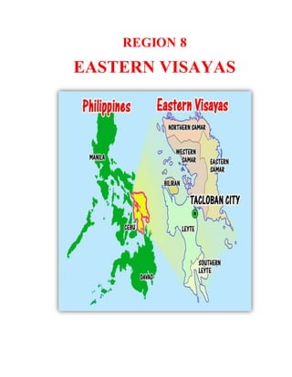
  • 2. HISTORY OF REGION VIII EASTERN VISAYAS Eastern Visayas is one of the two regions of the Philippines having no land border with another region, MIMAROPA being the other, and is designated as Region VIII. It has six provinces: Biliran, Eastern Samar, Leyte, Northern Samar, Samar and Southern Leyte are some of the poorest provinces in the country. The economy is deeply agricultural their farming practices in some parts of the region date back to the early 1800's. Agricultural development has been slow and highly selective to few pockets of more enterprising (and well-off) farmers because of the typically rugged interior of the two main islands, agriculture has been limited to mostly the coastal areas and small inland valleys. Heavy industry has been confined to a small industrial zone on the northwest of Leyte Island much of the hinterlands, especially in Samar, is now heavily forested having had a chance to recuperate from the devastating logging operations in the 1970's and 1980's. It was Samar and Leyte which the renowned Portuguese explorer Ferdinand Magellan first saw and landed on after his long voyage across the Pacific in 1521.The first Christians in Southeast Asia were the people of Limasawa where the first mass was held. Five centuries later, General Douglas MacArthur led the Allies to victory in the Battle of Leyte wherein the ensuing naval battle, now known as the Battle of Leyte Gulf.Leyte became the secure foothold of the Allies in conquering back the archipelago, and eventually the rest of Asia, from the Japanese. GEOGRAPHICAL CONTEXT Eastern Visayas lies on the east central part of the Philippine archipelago. It is composed of two main islands, Leyte and Samar, which formed the eastern most coast of the archipelago. It is bounded by the Philippine sea on the east and north with San Bernardo Strait separating Samar island from southeastern Luzon: Camotes sea and Visayas sea on the west: Bohol sea on the south with Surigao Strait separating Leyte island from northwestern Mindanao. It has a total land area of 2,156,285 hectares or 7.2% of the country’s total land area. 52% of its total land areas are classified as forestland and 48% as alienable and disposable land. POLITICAL DIVISIONS Officially known as Region VIII, Eastern Visayas has 6 provinces, 12 districts, 7 cities, 136 municipalities, and 4,390 barangays.  Biliran (capital Naval): lone district, 8 municipalities, 132 barangays
  • 3.  Eastern Samar (capital Borongan City): lone district, 22 municipalities, 1 city, 597 barangays  Leyte (capital Tacloban City): 5 districts, 40 municipalities, 3 cities, 1,641 barangays  Northern Samar (capital Catarman): 2 districts, 24 municipalities, 569 barangays  Samar (formerly Western Samar) (capital Catbalogan City): 2 districts, 24 municipalities, 2 cities, 951 barangays  Southern Leyte (capital Maasin City): lone district, 18 municipalities, 1 city, 500 barangays DEMOGRAPHICS Population census of Eastern Visayas Year Total population 1990 3,054,490 2000 3,610,355 2007 3,912,936 2010 4,101,322 2013 3,880,148 CLIMATE There are two types of climate prevailing in the region under the Corona system of classification: Type II and Type IV. Type II climate is characterized by having no dry season but a pronounced maximum rainfall from November to January. Samar Island and the eastern part of Leyte Island fall under this type of climate. Type IV on the other hand has an even distribution of rainfall the year round and a short period of dry season that can be observed starting February up to May. This type of climate is well exhibited at the western half of Leyte island and some portion of Samar which covers the municipality of Motiong up to San Isidro of Northern Samar. The eastern portion of the region is frequently visited by storms from the Pacific Ocean. The region receives heavy rainfall throughout the year with no pronounced dry season. In November 2013, the region was hit with the highest death toll in the country by Typhoon Haiyan, the second deadliest typhoon ever to hit the Philippines.
  • 4. NATURAL RESOURCES The region's sea and inland waters are rich sources of salt and fresh water fish and other marine products. It is one of the fish exporting regions of the country. There are substantial forest reserves in the interiors of the islands. Its mineral deposits include chromite, uranium, gold, silver, manganese, magnesium, bronze, nickel, clay, coal, limestone, pyrite and sand and gravel. It has abundant geothermal energy and water resources to support the needs of medium and heavy industries. CHROMITE BRONZE MAGNESIUM SILVER LIMESTONE NICKEL CHARCOAL CLAY URANIUM
  • 5. ECONOMY The Department of Agriculture's 2011 report said agriculture, fishery and forestry accounted for 20.49% of the regional economy. In that year, palay and coconut were the leading commodities to agricultural production of Eastern Visayas. The region was 7th in palay production and 2nd in coconut production. The agricultural land area in Eastern Visayas covers 723,048 hectares, or 31% of the region's total land area of 2,325,395 hectares. In the agency's September report, low volume of fish catch and limited supply of fishery products were noted due to expensive fishing trips and rough seas. LAND USE Eastern Visayas is primarily an agricultural region with rice, abaca, corn, coconut, sugarcane and banana as major crops. Its total land area is 21,431.7 sq. kms. 52% of its total land area is classified as forestland and 48% as alienable and disposable land. CULTURE AND BELIEFS Cultural groups Region VIII is inhabited by the Waray-Warays, the country’s fourth largest cultural linguistic group. Cebuanos from the nearby island of Cebu live in Ormoc City, Western Leyte and parts of the Southwest of Leyte. Languages Waray-Waray is the lingua franca of the Eastern Visayas Region and mostly spoken on the island of Samar, Biliran, Tacloban and north-eastern Leyte. A Samar language, distantly related to the languages of the region, called Abaknon is spoken in the island of Capul in Northern Samar. Cebuano is spoken in western, central, and southern parts of Leyte and in Southern Leyte. Other languages spoken in Eastern Visayas are Baybayanon, which is spoken in Baybay with 10,000 speakers and Kinabalian, which is spoken in the municipality of San Juan, Southern Leyte.
  • 6. Dances Tinikling, the Philippines' national dance is folkdance that originated from the region. But the most popular cultural dance among Warays is the Kuratsa, danced during feast celebrations and special gatherings. The Leyte Kalipayan Dance Company, a local cultural group, held highly successful performances around the world. Tinikling Kuratsa Music Waray people are music lovers whose folkloric music are mostly ballads in form, famous of which is "Dandansoy" while "Iroy nga Tuna" (Motherland) is a patriotic song.
  • 7. 1. History of Eastern Samar,Philippines (The Land of Good Harbors) This article from the LGU of Eastern Samar Province Eastern Samar became an independent province by virtue of Republic Act No. 4221 which Congress approved on June 19, 1965 dividing the then existing old province of Samar into three separate provinces, namely; Northern Samar, Western Samar (subsequently renamed Samar) and Eastern Samar. A plebiscite held simultaneously with the November 1965 general elections upheld the conversion of Eastern Samar into a separate province. In 1967 the newly created province elected its first set of officials and on January 2, 1968, the provincial board had its inaugural session in the Borongan Town Hall which served as the temporary provincial capital. Eight months later, the formal inauguration of the new province of Eastern Samar took place.Before its existence as an independent province, places which now form part of Eastern Samar played important roles in the history of our country. It was in Eastern Samar where Ferdinand Magellan landed in Homonhon Island in the town of Guiuan on March 16, 1521, in what is now officially recognized as the discovery of the Philippines by the
  • 8. Western World. Magellan called the place Zamal.Sustained contact with Western civilization occurred as early as 1596. Jesuit missionaries worked their way from the western coast of the island of Samar and established mission centers in what is now Eastern Samar territory. On September 28, 1901, Filipino rebels in the town of Balangiga attacked and almost wiped out American troops billeted in the municipal building and church convent. Now known in history books as the “Balangiga Massacre Day," the incident triggered a ruthless pacification campaign by US forces aimed at turning the entire island of Samar into a "howling wilderness." It was during this campaign that American soldiers took the Balangiga Bells from the Balangiga church as war trophies. The bells remain on display at Warren Air Force Base in Cheyenne, Wyoming. On October 17, 1944, US Army rangers landed on the island of Suluan in Guiuan where they fought their first battle on Philippine territory three days before Gen. Douglas MacArthur stormed the beaches of Leyte. Eastern Samar was the first area of the Philippines sighted by Magellan on March 16, 1521. The lofty mountains of Zamal as called by Magellan’s crew are the mountain ranges that separate the province from Western Samar and Northern Samar. The Spaniards, however, anchored at the tiny island of Homonhon on the southern side of the province. During the early days of Spanish rule, the Province of Samar, (of which Eastern Samar was a part) was called “Ibabao”. It was under the political and ecclesiastical jurisdiction of Cebu. Samar was made a separate province from Cebu in 1768. From its capital, Catbalogan, the administration of the encomiendas in the eastern coast was controlled. Samar was divided into three provinces, namely: Eastern Samar, Northern Samar and Western Samar, by virtue of Republic Act No. 4221. The Law was overwhelmingly ratified in a plebiscite on November 9, 1965. GEOGRAPHICAL CONTEXT There are three provinces located in the Island of Samar: Western Samar, Eastern Samar and Northern Samar. Eastern Samar is located in Eastern Visayas within Region VIII, 11.6667° N, 125.5000° E - Eastern Samar, Coordinates. Eastern Samar has 4,640 square km area. DEMOGRAPHIC Eastern Samar Population (as of 2010 census) = 428,877 Eastern Samar Population (as of Aug 1, 2007 census) = 405,114
  • 9. HOTSPOT AREAS IN EASTERN SAMAR Small tropical haven in Eastern Samar, whether it’s the creamy sands and azure waters of Suluan Island or the marine life sanctuary of Kantican Island, which also houses an experimental pearl farm. Amandaraga is the name of Lawaan’s waterfalls which resembles a maiden’s hair. Favorite island hopping destinations are the twin islands of Ando and Divinuvo in Borongan City. For camping and trekking, explore the Borongan- Llorente Closed Canopy Forest. The ultimate crowd-drawer, however, is the rising star that is Calicoan Island. Despite the allure of its inland lagoons and wild virgin forests, both locals and foreigners head here for one thing: surfing. The ABCD Beach, the shoreline of choice if you’re staying at The Surf Camp or the Calicoan Villas, offers waves suitable for both beginner and advanced surfers. The local surf season runs from April to November. Eastern Samar is sprinkled with locations that have hosted some of the country’s most interesting historical events. Homonhon Island was where Magellan first set foot on Philippine soil in 1521. Tubabao Island sheltered thousands of Russian refugees in the 1950s; the refugees were survivors of the Bolshevik Russian Revolution and Russian Civil War. And the modest town of Balangiga was the site of a noteworthy chapter in Philippine history — a powerful story involving resistance, revenge and church bells.
  • 10. The province also hosts the Padulong Festival every September, an energetic and grand socio-cultural celebration filled with colourful parades and street dancing. FESTIVALS IN EASTERN SAMAR March 16 (Karapayan Festival, Blessed Virgin Mother) – A colorful festival depicting how the early Guiuan Townsfolk enjoyed nature’s bounties, rich marine life, fertile land, verdant forest. It is also a thanksgiving to their Patroness, the Blessed Virgin Mother.  May 1 (St. Francis of Assisi) – Mercedes May 8 (The Divine Child) – Lawa-an  May 15 (St. Isidore the Farmer) – Salcedo  May 27 (St. Isidore the Farmer) – Maslog  June 13 (St, Anthony of Padua) – Llorente  July 15 (Our Lady of the Seven Sorrows) – San Julian  July 22 (St. Mary Magdalene) – San Policarpo  July 25 (St. James the Greater) – Taft  July 30-31 (St. Ignatius of Loyola) – Sulat  August 1-2 (Our Lady, Queen of Angels) – Can-avid
  • 11.  August 10 (St. Lawrence of Rome) – Balangiga  August 16 (St. Roche) – Maydolong  August 16 (St. Joachim) – Dolores  August 27 (St. Joseph) – Gen. MacArthur  August 31 (St. Raymond Nonnatus) – Arteche  September 8 (The Nativity of Our Lady) – Borongan  September 10 (St. Nicholas of Tolentino) – Quinapundan  September 15 (Our Lady of Seven Sorrows) – Hernani  October 7 (Our Lady of the Holy Rosary) – Jipapad  October 12 (Our Lady of the Pillar) – Giporlos  October 19 (St. Peter of Alcantara) – Oras  December 8 (Our Lady of the Immaculate Conception) – Guiuan COMMON PRODUCTS PRODUCT : Squash Cookies PRODUCER: San Mateo ARB MPCZ ADDRESS: DR Provincial Office, Borongan Easter Samar CONTACT PERSON/S : Conrado Amano CULTURE AND BELIEFS  Religion The people of the province are devoted Christians where 96% adhere to Roman Catholicism. The dominant Catholic faith influences the events of the provincial education, politics and social functions of the people. Other Christians usually form the remaining groups of believers such as Jehovah's Witnesses, Iglesia Ni Cristo, Baptists, Methodists, Church of Christ of Latter Day Saints Seventh-day Adventist. Non- Christians (mostly Muslims) are also found.
  • 12. 2. HISTORY OF LEYTE (Mahaba Island:An UnderwaterParadise) Leyte has a colorful history. Leyte like the Samar when it comes to their province, point out of that their forebear were among the first to welcome the Spaniards but they were also among the first to resist the invaders. Leyte was one of the provinces where the early seeds of nationalism were planted. In 1521, Magellan sailed from the island of Homonhon, Samar to the island of Limasawa, Leyte, entered into a blood compact with Rajah Kolambu. On Eastern Sunday, March 31, of that year, was celebrated the First Mass in the Philippines. Some historical researchers, however, are now disputing this. The next century witnessed a religious uprising lead by Bancao, the Limasawa chief, and his high priest, Pagail. The revolt began in Carigara and spread to neighboring towns before it was quelled. 27 years after the 1622 uprising, another revolt hit Leyte - an offshoot of the Sumoroy rebellion then simmering in Samar. And in the center of the disturbances, the village of Bacor, rebels burned the church and its convent. By 1768, Leyte, now separated from Samar, became a politico-military province. The set up continued until the end of Spanish rule, when Gen. Vicente Lukban took over Leyte and Samar in the name of the Revolutionary Government. It was World War II, however, which placed Leyte on the world map. On October 20, 1944, Gen. Mac Arthur, at the head of the largest US fleet of transport and warships, and accompanied by Commonwealth President Sergio Osmeña and Gen Carlos P. Romulo, landed on Palo, Leyte to reclaim the Philippines from the Japanese. On May 22, 1959, the province was divided into
  • 13. Leyte and southern Leyte. Information provided by the Department of Tourism of Government of the Philippines. GEOGRAPHICAL CONTEXT Leyte is an island province located within Region VIII- Eastern Visayas 10.8333° N, 124.8333° E - Leyte, Coordinates. Leyte has 6,515 square km area. DEMOGRAPHIC Leyte Population (as of Aug 1, 2007) = 1,722,036 Leyte Registered Voters (2009) = 908,480 Leyte population (as of year 2010) = 1,567,984 HOTSPOT AREAS IN LEYTE An American general famously promised he would return here. After one visit, so will you. Leyte is home to two of the most famous events in Philippine history. First, the Battle of Leyte Gulf is the largest naval battle of World War II. It took place from 23-26 October 1944 between combined US and Australian forces and the Imperial Japanese Navy. Second, a promise that involves Gen. Douglas MacArthur and Red Beach in Palo is a site known more for its history than its shoreline. Allied Forces led by Gen. Douglas MacArthur returned here on 20 October 1944 to aid the Philippines against the Japanese invasion, fulfilling his oft-quoted promise, “I shall return.” That moment is commemorated by the Leyte Landing Memorial that stands at Red Beach today. Apart from its historical sites, Leyte is also a good jump-off point to find some isolated isles that look straight out of the pages of a travel magazine. Kalanggaman Island in Palompon is the quintessential tropical island, where
  • 14. gradient blue waters lap peacefully at fine sugary sand. Cuatro Islas (“Four Islands”) in Inopacan and Hindang are another pretty bunch. Of these islands, Digyo is a standout: palm trees, clear waters, and barely any other tourists in sight. Snorkel in its shimmering waters to swim amongst corals and fish. Another great place for swimming, snorkeling, kayaking and camping can be found in Canigao Island off the municipality of Matalom. Its assets are beautiful white sand and crystal clear waters. Tanauan is the birthplace of skimboarding in the Philippines and host to annual national skimboarding competitions. The Mahagnao Volcano Natural Park may also trek and picnic surrounded by lush foliage, visit hot springs, take a boat ride across a lake, or trek to volcanic craters. Local specialties in Leyte are the two of the most popular are binagol, a mix of talyan (a local root crop), coconut milk, and sugar steamed inside coconut shells; and moron, glutinous rice cooked in coconut milk and flavored with cocoa. Other favorite native delicacies are the pastillas de leche, made from pure cow’s milk and roscas, traditional rusk bread especially baked by the women of Barugo. It is made from egg yolk, wheat flour, milk, shortening, and flavored with anise seeds. FESTIVALS IN LEYTE August 29 (Buyog-Buyogan, St. Francis Xavier) – Abuyog "Buyog" (bees) dancers, depict the origin of the town's name in a well choreographers dance
  • 15. August 14-15 (Pasaka Festival, Our Lady of Assumption) – Tanauan Leyte, Legend has it that Tanauanons witnessed the assumption of Blessed Mother into Heaven. After seeing this great Miracle, they rejoiced and celebrated the event with dances.  January 15 (Sinulog, Holy Child) – Isabel  January 15 (Holy Child) – Tabango  January 25 (Sto. Niño Hiyas ka sa Bato, Holy Child) – Bato  Second Saturday of February (Sinulog, Holy Child) – Villaba  April 28 (Viajedores) - La Paz  May 3 (Pamagpagan, St. Francis of Assisi) – Pastrana  Second Saturday of May (Tambula Festival, St. Vincent Ferrer) – Babatngon  May 8 (Sangkaan, St. Michael the Archangel) – Hindang  May 8 (Tolo-usa, St. Michael the Archangel) – Tolosa  May 11 (Pahoy-Pahoy Festival, St. Joseph) – Barugo  May 13 (Our Lady of Fatima) – Ormoc City  May 15 (St. Isidore the Farmer) – Inopacan  May 15 (St. Isidore the Farmer) – MacArthur
  • 16.  May 15 (St. Isidore the Farmer) – Merida  May 15 (Sinulog, St. Isidore the Farmer) - San Isidro  May 18-19 (Sanggutan Festival) – Barugo  May 27 (Dinagamihan, St. Joseph) – Dagami  May 27 (St. Joseph) – Matalom  May 28 (Karayhakan, St. Michael the Archangel) – Javier  June 5 (Minoro, Holy Name of Jesus) – Capoocan  June 11-12 (St. Anthony of Padua) – Matag-ob  June 13 (Lukayan, St. Anthony of Padua) – Mayorga  June 13 (St. Anthony of Padua) – Tunga  June 13 (St. Anthony of Padua) – Tabon-Tabon  June 19 (Lingganay Festival, Holy Trinity) – Alang-Alang  June 28-29 (Piñahan, Sts. Peter and Paul) – Ormoc City  July 16 (Makabugwas, Triumph of the Holy Cross) – Carigara  July 25 (Caballero, St. James the Great) – Albuera  July 26 (Pamilipig, St. Anne) - Sta. Fe  June 30 (Pintados de Leyte Festival, Holy Child) - Tacloban City  August 8 (Tribung Bagong Silang, Transfiguration of Our Lord) – Palo  August 11-12 (Hulatan Festival, St. Roche) – Julita  August 15-16 (Lubi-Lubi Festival, Our Lady of Fatima and St. Roche) – Calubian  September 8 (Karatong, Our Lady of Refuge) – Dulag  September 21 (Tambalan, St. Matthew the Apostle and Evangelist) – Jaro  September 28 (St. Michael the Archangel) – Javier  September 29 (Bathan Festival, St. Michael the Archangel) - San Miguel  September 28-29 (Kaplag Festival, St. Michael the Archangel) – Mahaplag  October 20 (city charter day) – Ormoc City  October 20 (Leyte Landing Anniversary) – Palo  December 3 (St. Francis Xavier) – Palompon  December 8 (Karu-Katik, Festival, Our Lady of the Immaculate Conception) – Burauen  December 8 (Hiraite, Our Lady of the Immaculate Conception) – Leyte  December 27 (Sidong Festival, Our Lady of the Immaculate Conception) – Baybay City  December 30 (Kan-anga Festival) – Kananga  December 31 (Alikaraw Festival, Our Lady of the Immaculate Conception) – Hilongos  Black Saturday (Torugpo) – Carigar  Easter Sunday (Sunduan Ha Carigara) – Carigara
  • 17. COMMON PRODUCTS LEYTE PRODUCT: BINAGOL PRODUCER: TERRY’S CULTURE AND BELIEFS  Languages/dialects "Waray" is generally spoken by the people of Leyte except those who live in the western side who generally speak Cebuano 3. History of Northern Samar,Philippines (Hidden Paradise of Visayas) The province of Northern Samar was created by Republic Act No. 4221 which was approved by Congress on June 19, 1965 dividing the whole island of Samar into three independent provinces namely; Northern Samar, Western Samar
  • 18. (subsequently renamed Samar) and Eastern Samar. As embodied in this Act, the eastern province is composed of 24 municipalities with Borongan as the capital. The province is located in the eastern part of the Philippine Archipelago, bounded on the north by the San Bernardino Strait, on the east by the Pacific Ocean, on the west by the Samar Sea, and on the south by Samar. It is composed of 24 municipalities and 569 barangays covering a total land area of 3,692.9 square kilometers. Catarman is the provincial capital and center of trade and commerce. Northern Samar is strategically located as the gateway to Visayas and Mindanao from Luzon. It is 743 kilometers from Manila and can be reached by 1 hour and 20 minutes plane ride to Catarman or 14 hours bus travel through the Pan Philippine Highway passing Bicol Region and traversing San Bernardino Strait via ferry boat in the primary ports of San Isidro and Allen, from Matnog, Sorsogon. The route to Mindanao is through Tacloban City, being connected to Northern Samar by the famous San Juanico Bridge, via ferryboat in Liloan, Southern Leyte to Surigao. Majority speak Waray dialect, along with Inabaknon, which is predominantly spoken in Capul Island. The province is endowed with metallic minerals such as copper, aluminum and bauxite which can be found particulary in Biri, Mapanas and San Isidro. Major agricultural crops include coconut, abaca, palay, rootcrops and other subsistence crops. Its rich fishing grounds produce spanish mackerel, grouper, tuna, big-eyed scad, round scad, herring, anchovies and salmon. Other aquatic products include cattlefish, crabs, shrimps, squid and lobsters. Northern Samar is famous for its natural rock formations found in Biri Island and white silky sand beaches in San Jose and Lavezares. A visit to the century old church in Capul Island brings you to the 16th century. Only missionary fervour made possible the building of this church on this island. GEOGRAPHICAL CONTEXT There are three provinces located in the Island of Samar: Western Samar, Eastern Samar and Northern Samar. Northern Samar is located in the northernmost portion of Samar, the third largest island of the country. It is 732.72
  • 19. kilometers southeast of Manila. The Pacific Ocean bound Northern Samar on the east, the San Bernardino Strait on the north, the Samar Sea on the west and Samar on the south. 12.3333° N, 124.6667° E - Northern Samar, Coordinates. Northern Samar has 3,692 square km area. DEMOGRAPHIC In the 2007 Census of Population, the province registered a total population of 549,759, posting an average annual growth rate of 1.3 percent. Its population density is recorded at 149 persons per square kilometer. Population: 589,013 (2010) HOTSPOT AREAS IN NORTHERN SAMAR Lying to the north (of the South) are the rural province of Northern Samar and its capital, Catarman. The towns are small and sleepy; the landscapes sometimes more unruly than picture-perfect. But this often-overlooked province holds some unbelievable surprises. For starters, beaches are plentiful here. Stay at one of the local resorts to enjoy a stretch of sand to yourself and savor cold drinks and good conversation under the moonlight. Pick from the honey-colored shores of Onay Beach in Laoang and or the sparkling white sands in San Antonio Island, Dalupiri Island, or Spice of Life. For somewhere off the beaten path, explore the Naranjo group of islands such as Sila Island with its pinkish sand and Panganoron Island with white sand. Located close to the National Highway is the municipality of Victoria that serves as the jump-off point to San Antonio Island. The 280-meter steel bridge passing through Mawo River serves as its landmark. The coast here is lined with beautiful beaches have mountains as their back drop. Caves, springs, waterfalls and rivers are accessible too. Allen is the municipality that connects Luzon to Northern Samar via the RORO (roll on – roll off) boats. In here you’ll find Felixville Resort, Wayang-Wayang Beach Resort, and Paradise Beach which are all budget-friendly and definitely good for big groups. Capul Island also has its share of white
  • 20. beaches and snorkelling spots. It gets its name from Acapulco in Mexico, owing to its former life as a guidepost for galleons sailing trade routes between Acapulco and Manila. Go beyond the beach and explore the island’s historical structures, which date back to the late 1800s: the Capul Island Lighthouse, Capul Church and Fortress, and the Batag Island Lighthouse.For bird watching, the Lalaguna Mangrove Forest in Lavezareshosts different migratory birds. It’s best if you ride a paddle boat here to get closer to nature. It’s Biri Island, however, that really amps up Northern Samar’s wow factor. Forget food and drinks,what you absolutely shouldn’t forget to pack is your camera. Stunning rock formations — monstrous cliffs, boulders and crags naturally carved by the ocean waves and winds — make for views that will bring out the photographer in anyone. FESTIVALS IN NORTHERN SAMAR Second Week of January (Embajada) – Catubig A festivity practiced by the People of Catarman since 1922, featuring a re- enactment of how the Filipino natives were christianized by the Spanish Conquistadores. It was officially made into a provincial festival in 1992.  Last Sunday of January (Sakay-Sakay Fluvial Procession) – Laoang  March 16 (Parayan Harvest Festival) – San Roque  April 29 (St. Vincent Ferrer) – San Vicente  May 14-15 (St. Isidore the Farmer) – Lope de Vega  May 14-15 (St. Isidore the Farmer) – Silvino Lobos  May 14-15 (St. Isidore the Farmer) – San Isidro
  • 21.  Second Week of June (Bangkules Festival) – Palapag  June 11-12 (Manoglaya Festival, St. Anthony of Padua) – San Antonio  June 11-12 (St. Anthony of Padua) – Mondragon  June 19 (Embajada Festival) – Catarman  June 24 (St. John the Baptist) – Pambujan  June 24-25 (St. James the Greater) – Allen  June 24-25 (St. Vincent Ferrer) – Biri  July 13-14 (St. Bonaventure) – Lapinig  July 18-19 (Our Lady of the Angel) – Mapanas  July 26-27 (St. Joseph the Worker) – Catubig  July 28-29 (St. Anthony of Padua) – San Jose  July 30-31 (St. Ignatius of Loyola) – Capul  August 5-7 (St. Anne) – Victoria  August 9-10 (Ati-Atihan Festival, Most Holy Name of Jesus) – Bobon  August 14-15 (Our Lady of the Assumption) – Palapag  August 15-16 (St. Roche) – San Roque  August 21-22 (Our Lady of Salvation) – Lavezares  August 28-29 (Our Lady of the Annunciation) – Catarman  September 7-8 (Our Lady of the Nativity) – Las Navas  September 14-15 (St. Michael the Archangel) – Gamay  September 28-29 (St. Michael the Archangel) – Laoang  October 6-7 (Our Lady of the Holy Rosary) – Rosario COMMON PRODUCTS PRODUCT: Coconut Groove Coco Vinegar PRODUCER:Galutan Primary MPC ADDRESS:Barangay Galutan, Catarman, Northern Samar CONTACT PERSON/S:Emma Humamil
  • 22. CULTURE AND BELIEFS  Religions The communities of this province are predominantly Catholic (95%). Other religious groups are Members Church of God International (Ang Dating Daan), Iglesia ni Cristo, Philippine Independent Church (Aglipayan), Seventh-Day Adventists, Jehovah’s Witnesses, Church of Jesus Christ of Latter-Day Saints and other Christian sects. A small number of population are Muslim.  Languages Majority of the people in the province of Northern Samar speak the Ninorte Samarnon, a variation of Waray-Waray. About 4.5 percent of the population, especially in the island towns, speak Cebuano, while a minority speaks Inabaknon, a unique language said to be one of the most preserved languages to date. This is the native tongue of the populace in the island town of Capul. Ninorte Samarnon usually is further subclassified into Balicuatro, Central and Pacific speakers. Tagalog, Bicol, and English are also widely used and understood in Northern Samar. 4. History of Samar, Philippines (Splendor Between Mountain and Sea/ Share in Nature’s Beauty) Prior to the approval of Republic Act No. 4221 on June 19, 1965, Samar province comprised the whole island of Samar. Under this act, the western portion was created as a separate province named Western Samar. A
  • 23. subsequent legislation (Republic Act No. 5650) however, changed the name of the province of Samar on June 21, 1969. The Jesuit missionaries founded Samar in 1596. They introduced the Roman Catholic faith to the people of Samar. When the Jesuits left Samar in 1768, the Spanish Franciscans took over the administration. The former names given to Samar were Zamal, Ibabao, Achan and Tandaya. Legend stated that when the Spaniards first set foot in Homonhon, they met a wounded native from whom they asked the name of the place. The wounded man did not understand Spanish. He thought they were asking what happened to him and he replied "samad" meaning wound in the local dialect. So, the navigators adopted the name for the island with a slight alteration of the last letter, from Samad to Samar. During the early days of Spanish occupation in the Philippines, Samar was under the jurisdiction of Cebu. Later, it was declared a separate province, but in 1735, Samar and Leyte were united into one province with Carigara, in Leyte, as the capital. The union, however, did not prove satisfactory. So, in 1968, Samar has emerged as an independent political unit with Catbalogan as its capital. On January 1900, the Americans captured the town of Catbalogan. Civil governments were established on June 17, 1902 and Julio Llorente was appointed as the first governor of Samar.During the administration of Governor Baltazar Avelino, Samar was converted into a first class "A" province. Calbayog City became a chartered city on July 16 by virtue of Republic Act no. 328. GEOGRAPHICAL CONTEXT There are three provinces located in the Island of Samar: Western Samar, Eastern Samar and Northern Samar.Samar Province is 802 kilometers from Manila. It lies southeast of Luzon and occupies the westernmost section of the Samar Island in the visayas islands within Region VIII. To the north, it is bounded by the province of Northern Samar; on the east by the province of Eastern Samar; to the west by the Samar Sea and to the south by the Leyte Gulf.
  • 24. Samar is connected with the province of Leyte thru Marcos Bridge on the southwest across the San Juanico strait. 12.0000° N, 125.0000° E - Samar, Coordinates. Samar has 6,048 square km area. DEMOGRAPHIC Western Samar Population (as of Aug 1, 2007 Census) = 695,149 Western Samar Registered Voters (2009 COMELEC) = 442,662 Western Samar population = (as of year 2010) 733,377 HOTSPOT AREAS IN SAMAR On the western side of Samar Island, nature-lovers will find unusual landscapes and a whole lot of spelunking sites. They call Samar the “Caving Center of the Philippines” Its most famous are the Sohoton Caves, a two-hour trip from the town of Basey. This 840- hectare park features limestone walls, a natural rock bridge, underground rivers, lush forests and caves with stunning and expansive interiors. There’s also Langun-Gobingub Cave in Calbiga, one of the largest karst caves in Southeast Asia. Swimming spots also abound.Look Beach in Calbayog City is boasting icy blue waters facing the Samar Sea and natural rock formations that present a more rugged beach-going experience.A ticog mat for your seaside picnics; ticog is made with a local weed that, when woven, makes for smooth and supple mats, tote bags, and even home and office decors. Take an exciting river ride in a dug-out boat without outriggers at the Ulot Watershed Ecotourism Loop in Paranas. Be thrilled as expert boatmen manoeuvre the torpedo boat between rocks up and downstream the Ulot River. And dare to plunge into the waters by leaping from a huge boulder.
  • 25. Those in the mood for something with more kick should check out Samar’s waterfalls. The Bangon-Bugtong Falls cascade elegantly into a large circular pool, while the fun Mawacat Slide lets you zoom down a mossy passageway into the waters below. The Lulugayan Falls and Rapids feature a strong and thundering current that feeds into the Calbiga River and makes for enjoyable white water rafting. And while you’re here, make sure not to bypass the quiet town of Marabut and Daram. Marabut rewards its visitors with islets fit for snorkelling and diving, as well as gargantuan rock islands that artfully jut out from the sea. Have a close encounter with colourful fishes and rare giant clams while snorkelling at Agutayan Island in Daram. FESTIVALS IN SAMAR May 25 (Pahoy-Pahoy Festival, Our Lady of the Annunciation) – Calbiga Pahoy-Pahoy Festival is a ritual and has become part of Christian tradition of the annual town fiesta. It is held every May 25 in Calbiga, Samar. The town of Calbiga showcases giant pahoy-pahoy (scarecrows) made of indigenous materials dancing in the streets to the sound of musical instruments made up of bamboos, cans and stones that scare the maya or ricebirds. It features the
  • 26. legend of Pahoy as they drive off the evil spirits and ricebirds that ruined their rice lands and agriculture. They commemorate the time when the tribe "humanoid" saved the village settlers from famine.  January 15 (Daramsiyaw Festival, Holy Child) – Daram  January 15 (Kinarawgan Festival) – Marabut  February 22 (Holy Child) – Pagsangjan  May 1 (St. Joseph the Worker) – Hinabangan  May 5 (Sacred Heart of Jesus) – Almagro  May 17 (St. Paschal Baylon) – Jiabong  August 24 (Mangirisda and Pintados Festival, St. Bartholomew the Apostle) – Catbalogan City  September 1-8 (Sarakiki Festival, Our Lady of the Nativity) – Calbayog City (Samar)  September 28-29 (Baigan/Kawayan Festival, St. Michael the Archangel) – Basey  September 29 (Karabaw Festival, St. Michael the Archangel) – Gandara  October 3 (Soleda, Our Lady of Solitude) – Calbayog City  October 16 (Grand Caracol, St. Raphael the Archangel) – Calbayog City COMMON PRODUCTS PRODUCt: Tikog Mats PRODUCER : Bulao ARB Multi- Purpose Cooperative ADDRESS: Barangay,Bulao, Basey, Samar CONTACT PERSON/S: Nestor P. Dasig CONTACT NUMBER/S : (055)n2512807; (055) 2512365
  • 27. CULTURE AND BELIEFS  Religion Samar (Western Samar) is predominantly Roman Catholic. The Catholic Hierarchy (2014) stated that 95 percent of its population adheres to Roman Catholicism. Some other Christian believers constitute most of the remainder such as Born Again Christians, Iglesia Ni Cristo, Baptists, Methodists, Jehovah's Witnesses Church of Christ of Latter Day Saints and Seventh-day Adventist. Muslims are also present  Language Residents of Samar are mostly Waray, the sixth largest cultural-linguistic group in the country. 90.2 percent of the household population speaks the Waray-Waray language, while 9.8 percent also speak Cebuano; 8.1 percent Boholano; 0.07 percent Tagalog; and 0.5 percent other languages. There are two types of Waray spoken in the province, Waray Lineyte- Samarnon which is spoken from the southernmost tip of the province up to the municipality of Gandara and Waray Calbayog, an intermediary between the Waray of Northern Samar and the Waray of Samar, spoken in Calbayog City, Santa Margarita, and in some parts of Tagapul- an, Santo Niño and Almagro. Cebuano is spoken in some parts of the first district of Samar, mainly in Calbayog City, Almagro, Santo Niño and Tagapul-an. English and Chinese languages are also spoken
  • 28. 5. History of Southern Leyte, Philippines (The Centuries Old Charmer) Father of the Province of Southern Leyte : Hon. Congressman Nicanor E. Yñiguez rough House Bill No. 1318. Legal Basis of the Creation of the Province of southern Leyte: Republic Act No. 2227 signed by President Carlos P. Garcia on May 22, 1959, Friday at 10:00 o’clock in the morning. Effective Date of the Creation of the Province of Southern Leyte: July 1, 1960 Even before the fall of the Spaniards to the Americans on August 13, 1898 there had been already been established in Western Leyte a Court of First Instance. There was the office of "Promoter Fiscal" equivalent to the Provincial Fiscal and the office of "Administrator de Hacienda" equivalent to the Provincial Treasurer. With the change of sovereign power the positions were abolished except the Fiscal's who remained hearing cases from Palompon to Hinunangan. Because of the difficulty of transportation and managing the affairs of government in Tacloban, the division of Leyte into two provinces was thought to be the only solution. Prominent leaders of the West Coast rallied to the general movement of a Western Leyte. In 1919, Rep. Ciriaco K. Kangleon representing the 2nd district from Inopacan to Cabalian from 1919-1922
  • 29. presented the first bill for the division of Leyte but lost in the Senate by one vote. In 1922, Tomas Oppus renewed the move by presenting House Bill No. 254, which became Act No. 3117. According to the said law, occidental province would embrace the towns of Villaba to Hinunangan, inclusive. The law never became effective since the governor-general did not proclaim it. Then Act No. 3788 was passed redistricting Leyte province into five representative districts modifying the Division Law. Then in 1957, Nicanor Espina Ynigues, Jr. defeated Rep. Pajao. Ynigues filed a bill in the house creating the Province of Southern Leyte no longer the original Western Leyte of Occidental Leyte but only the Third District of Leyte comprising the municipalities of Maasin to Hinunangan, as specified under Act 3788. On Friday, May 22, 1959 at 10:00 o'clock in the morning, President Carlos P. Garcia signed the bill into law. Republic Act No. 2227, otherwise known as an "Act creating the province of Southern Leyte". Present and witnesses to the signing were Congressman Ynigues, Mayor Alfredo K. Bantug of Maasin, Atty. Manuel Enage, Sr., Erlinda Capili and Atty. Floro Kangleon, among others. On July 1, 1960, Southern Leyte was inaugurated as a province with sixteen municipalities: Maasin, as the capital town and seat of the provincial government, Malitbog, Bontoc, Sogod, Libagon, Pintuyan, San Francisco, St. Bernard, Cabalian (now San Juan), Anahawan, Hinundayan, Hinunangan and Silago. Three more municipalities were created subsequently, namely; San Ricardo from Pintuyan, Tomas Oppus from Malitbog and Limasawa from Padre Burgos. HISTORICAL GEOGRAPHICAL CONTEXT 10.3333° N, 125.0833° E - Southern Leyte, Coordinates Southern Leyte is one of the six provinces of Eastern Visayas or Region VIII. Canigao Channel bound it on the north by Leyte province; on the east by the Pacific Ocean; on the south by Mindanao Sea; and on the west the Canigao Channel. It covers about one-fourth (1/4) of the island of Leyte. It has 19 municipalities. Four island and islet are within the territorial jurisdiction of Southern Leyte: Panaon, the only island linked to the mainland by a bridge, the historic island municipality of Limasawa which is the site of the first Christian Mass in the Far East, and the islets of San Pedro and San Pablo in Hinunangan. Southern Leyte has 1,798 square km area.
  • 30. DEMOGRAPHIC Total Population of Southern Leyte is 399,137 (2010). HOTSPOT AREAS IN SOUTHERN LEYTE Southern Leyte offers peaceful and meditative retreats in the way of secluded shores and ancient bastions of faith. One of the most cool and clean waters from Southern Leyte are Canigao Island and Tahusan Beach or the white sands of Tangkaan Beach. Meander down the quaint pebble beaches of the San Pedro and San Pablo Islands off the coast of Hinunangan. Kuting Reef, in a private cove at Bay Asuncion in Macrohon, is another fine pebble beach that offers a simple tropical resort experience. Dive deeper into the island experience. The waters of Panaon Island in Liloan are part of the Mindanao Deep one of the deepest bodies of water in the world, second only to the Marianas Trench. Sogod Bay is another option: it holds 350 of the world’s 500 coral species, several sunken wrecks worth exploring, and the promise of sea turtles, dolphins and whale sharks. For landlocked fun, visit Magsuhot Park, a protected 500-hectare forest with four waterfalls that drop up to 60 meters.If you prefer dry land, the Big Plain (Patag Daku) in Libagon poses a major challenge to trekkers and climbers, while the caves at Cambaro and Guisohotan are equally exciting.The Agas-Agas Adventure Park also offers one of the country’s highest zip lines at almost 300 meters above ground. Meanwhile, the less adventurous can while away time at the beaches of San Pedro and San Pablo in Hinunangan and the Sulphur Spring in Anahawan.
  • 31. Those seeking more spiritual pursuits shouldn’t miss Limasawa Island, the site of the first Christian mass in the Philippines, held in 1521.The Lady of the Assumption in Jalleca Hills is the country’s tallest private shrine, with a 30-foot Marian statue and an adjacent chapel some 300 steps up.The San Francisco Javier Pilgrims Center in Hanginan is another chapel noteworthy for its location: 400 meters above sea level. In southern Leyte you may see in the city of ormoc the first guitar-shaped of Lake Danao, a pristine 148-hectare inland lake surrounded by verdant mountains and invigorating cool air, just a 30-minute drive from the city. Enjoy a picnic and banca (boat) ride or go biking and examine local flora and fauna, all the while soaking up the area’s hard-to-beat tranquility. The Queen Pineapple, Ormoc’s most famous produce and a top pick for pasalubong (gifts for friends at home). Savor its unparalleled sweetness with juicy slices fresh from the pineapple plantations north of the city in Kananga. The Leyte Geothermal Production Field (LGPF) in Tongonan, east of the city is the country’s biggest geothermal complex, supplying energy even to parts of Luzon and Mindanao. In the city, some leisurely meandering uncovers little gems. The seaside Sabin Resort is Ormoc’s most favored accommodation, boasting Filipino décor, a large pool, and a panoramic view. Hang out at local watering holes like the cozy café Bebida’s or head to the public market and try native fare like pacdol (a clear broth with carabao knee meat) at Doro’s carinderia (eatery). Spot the Philippine-Japanese Peace Memorial, a friendship token from Nagoya and Gifu after World War II.
  • 32. Check out the Puente De La Reina, a cobblestone bridge built in the 1800s that was used as a docking area for traders from around Asia; and the Sen. Dominador Tan Ruins, once one of the city’s most extravagant houses before World War II.You can also tee off at the 18-hole Leyte Golf and Country Club for games against a backdrop of rolling terrain and the Ormoc Bay. As the region’s economic center and one of the country’s fastest-growing cities, Tacloban City teems with energy. Though it hosts a number of festivals, Tacloban’s biggest are the Pintados-Kasadyaan Festival and the Sangyaw Festival, both in June. These vibrant affairs celebrate the city’s cultural and religious traditions and showcase local talent, creativity and fun. The line-up of activities includes parades, street dancing and contests. Food-tripping is also a growing leisure activity here, given the number of restaurants and mouth- watering fare begging to be sampled. Guiseppe’s serves traditional Italian cuisine such as homemade pasta and crispy, thin-crust pizzas. Ocho Seafood & Grill is arguably the city’s best seafood restaurant, where you can have everything from tuna belly to crab cooked to your liking. Their baked mussels, adobo oysters and fried fish skin go great with ice-cold local beer. Between bites, go for a sampling of Tacloban’s other attractions. Tee off at the San Juanico Park Golf and Country Club. It’s an 18-hole golf course with a beautiful clubhouse, an impressive swimming pool, hotel, and other amenities. On its outskirts lies the winding San Juanico Bridge, the longest bridge in the Philippines, snaking over two kilometers to connect the islands of Leyte and Samar. The ostentatious Santo Niño Shrine and Heritage Museum, built by former First Lady Imelda Marcos, has more than a dozen rooms full of treasures such as European chandeliers, Chinese ivory carvings and classical Filipino paintings. Nestled in a park, the Madonna of Japan is a post-World War II token friendship from Japan that depicts an unusual Buddhist-syle Virgin Mary. The stately Leyte Provincial Capital Building, built in 1924, boasts a striking neoclassical design. And though not quite as well-kept, Gen. Douglas
  • 33. MacArthur’s former headquarters and residence, the Price Mansion, still remains in the city. FESTIVALS IN SOUTHERN LEYTE January 15 (Sinulog Festival, Holy Child) – Malitbog The word Sinulog comes from the Cebuano adverb sulog which roughly means "like water current movement;" it describes the forward-backward movement of the Sinulog dance. The dance consists of two steps forward and one step backward, done to the sound of drums. The dance is categorized into Sinulog-base, Free-Interpretation, and street dancing. Candle vendors at the Basilica continue to perform the traditional version of the dance when lighting a candle for the customer, usually accompanied by songs in the native language.  January (Sakay-Sakay Festival, Holy Child) – Maasin City  January 15 (Holy Child) – Bontoc  March 31 (Holy Cross, Sinugdan Festival) – Limasawa  May 15 (St. Isidore the Farmer) – San Francisco  May 15 (St. Isidore the Farmer) – St. Bernard  June 5 (St. Joseph) – Hinundayan  June 13 (St. Anthony of Padua) – Anahawan  June 24 (St. John the Baptist) – San Juan  June 29 (Sts. Peter and Paul) – Hinunangan  July 25 (St. James the Apostle) – Padre Purgos  July 25 (St. James the Apostle) – San Ricardo  July 25 (St. James the Apostle) – Silago  July 25 (St. James the Apostle) – Silago  July 31 (St. Ignatius of Loyola) – Tomas Oppus  August 10 (Pabulihon Festival, city charter day) – Maasin City  September 29 (St. Michael the Archangel) – Pintuyan  September 29 (Manha-on Festival, St. Michael the Archangel) – Macrohon  December 8 (Our Lady of the Immaculate Conception) – Libagon  December 8 (Our Lady of the Immaculate Conception) – Sogod COMMON PRODUCTS
  • 34. SOUTHERN LEYTE PRODUCT : Brasha (Dried Pusit) PRODUCER : Islanders Multi-Purpose Cooperative ADDRESS:DAR Provincial Office, Southern Leyte CONTACT PERSON/S:Rogelio Manlangit CONTACT NUMBER/S : (0921) 9582954 CULTURE AND BELIEFS  Language The native language is a Boholano dialect variant of the Cebuano language. Natives also speak English and, to a much lesser extent, Spanish.  Religion Our Lady of Assumption Cathedral in Maasin City Limasawa, an island municipality to the south, is believed to be the site of the first Christian mass and the birthplace of Christianity in the Philippines, when Ferdinand Magellan, a Portuguese navigator and explorer landed on March 28, 1521. The first Holy Sacrifice of the Mass was held on March 31, 1521 led by Friar Pedro de Valderrama, the chaplain of Magellan
  • 35. during the expedition. The mass marked the start of Christian propagation.[23] People in the province are generally Roman Catholics. Generally, 89 percent of them adhere to the Roman Catholic Church but traditions still influence the people in the province. Aglipayan ranks second with 4.51 percent affiliates and Evangelicals with 2.03. Other religious affiliations include Iglesia ni Cristo, Jehovah's Witnesses, and the Seventh-day Adventist Church among others. Erected in 1968 the church can be found in the City of Maasin. The church is embellished with an ornate altar and images of saints believed to be the testament of continuing religiosity of the people in the province.  Beliefs Although most people are Christians, a very few who live in remote villages of the province hold on to pre-Hispanic influences and make offerings and sacrifices before planting their crops. Farmers ritually sacrifice chickens and pigs to ensure that the spirits or elementals which they believe to be the cause of good harvest will grant them one.  Religious events Fiesta, a Spanish term which means festivity, is celebrated in the province with prayer, food, drinking, dance and music. Every barangay of every town in the province has its own celebration date. For instance, Hinunangan celebrates a town fiesta on the 29 June with the St. Peter and St. Paul Fluvial boat parade the day before.[24] The kuratsa — a courtship dance-drama — highlights every occasion.[25] The province also holds its own festivals. "Sinulog sa malitbog" is an annual religious street pageant in Malitbog to pay homage to the Holy Child Jesus (Santo Niño) who is their town's patron saint. Its reception has grown steadily, with devotees from other places flocking to the town. Similarly, the historic and religious coming of the Spaniards is commemorated every 31 March in Limasawa with a cultural presentation and anniversary program dubbed "Sinugdan", meaning "beginning."[26] Other festivals held in the province to highlight events are Pagkamugna Festival and Pabulhon Festival in Maasin City, Karomata Festival in Beunavista, Pintuyan, Tangka-tangka Festival in Tangkaan, Padre Burgos and Manha-on Festival in Macrohon.
  • 36. 6. History of Biliran, Philippines (The Province of Magnificent Islands) During the early Spanish era, what is now called Biliran Island was known as Isla de Panamao. The term refers to an ethnic fishing net. The present name, believed to be adopted sometime between the late 1600s and the early 1700s, was, according to many publications, derived from a native grass called borobiliran which once grew abundantly on the island's plains. A contending theory states that the name came from the word bilir, which was defined in an old Visayan dictionary to be the “corner or edge of a boat, vase or anything protruding, like veins, or the furrow made by the plow.” The dictionary also gives biliran as an alternate spelling for bilir. This theory is supported by the fact that Biliran was site of the first large-scale shipyard, built in the 1600s. Galleons were built to support the Galleon trade between Manila and Acapulco in Mexico. The first town, named Biliran, was founded in 1712. During this time, the island was a part of the province of Cebu. Biliran, together with the islands of Samar and Leyte were constituted into a separate province in 1735. Later when Samar and Leyte were split into two provinces in 1768, Biliran became part of Leyte.During the World War II, Biliran had its own guerrilla forces under the Leyte command of Colonel Ruperto Kangleon. The guerrilla operation where of invaluable assistance to the successful landing of the American liberation forces at Palo, Leyte, on October 20, 1944 just before the Battle of Leyte Gulf. In 1945 liberated by the Philippine Commonwealth forces landed in Biliran with the local guerrilla forces by the attack of the Japanese troops from the island during the Battle of Biliran. In May 1735, representative inhabitants of Leyte petitioned Governor General Fernando Valdes y Tamon to allow them to resettle Biliran Island. They claimed it had been abandoned for the past 50 years and was presently inhabited by bagamundos (vagabounds) due to the frequent Moro raids.
  • 37. On 26 May 1754, the Moros destroyed the pueblos of Biliran in Leyte and Catbalogan in Samar. Panamao was reportedly razed to the ground and only the gobernadorcillo of Biliran pueblo escaped capture by the raiders. The settlements of Biliran, Caybiran, Mapuyo and Maripipi were also destroyed by the Moros. The Moros staged their attack by marching inland along a river in the province named Anas for a distance of 1.5-2 leguas (leagues). Having covered part of the interior around a mountain, they managed to capture the inhabitants, with the exception of the gobernadorcillo who had escaped. The houses and property of the natives were burned or destroyed. The church building suffered the same fate and its valuables were taken away by the raiders. When the Moro raiders have been neutralized in the early 19th century, the local inhabitants went into the business of organizing new pueblos (also known as town) in the present geography of Biliran Province. The inhabitants of Biliran Island petitioned for pueblo and parish status as early as 1712. The first parish priest was assigned in 1765 but its parish status was apparently withdrawn because of Padre Gaspar‘s apostasy. The parish was re-established on February 22, 1782. In 1828, Caibiran on the east became an independent pueblo and parish, the second to be created in Biliran Island.Naval became the third town, and it was carved out of the territory of Biliran town. It initially became a separate parish in 1860. The Spanish colonial government officially recognized its pueblo status on 23 September 1869, the petition for which was apparently submitted around 1861. Almeria became a separate town in 1886 and was named after a town in Spain of the same name. Maripipi used to be a barrio of Naval. It was officially inaugurated as a town in 1867, two years ahead of its mother town, then folded up and was reduced into a barrio of Almeria, and then became a town again in 1899. Maripipi and the new towns of San Clemente (later Kawayan), Culaba and Esperanza (later Cabucgayan) were created around 1899 by the revolutionary government under Pres. Emilio Aguinaldo. On April 8, 1959 Republic Act No. 2141 was signed into law effectively making Biliran a sub-province of Leyte. The island was only made an independent province on May 11, 1992 by virtue of Republic Act No. 7160, making it one of the newest provinces in the country. GEOGRAPHICAL CONTEXT Biliran Island lies off the northern coast of Leyte Island across Biliran Strait. To the southeast is Carigara Bay, to the northeast is the Samar Sea, and across this sea is Samar Island. To the west is the Visayan Sea and Masbate lies 30
  • 38. kilometres (19 mi) to the northwest. 11.4667° N, 124.4833° E - Biliran, Biliran, Coordinates DEMOGRAPHIC Total Population of Biliran (as of May 1, 2010): 161,760 Total Registered Voters of Biliran (as of 2010): 81,958 HOTSPOT AREAS IN BILIRAN The province holds a multitude of photogenic waterfalls, whose features range from impressive drops to inviting swimming spots. The Tomalistis Falls are most notable for its water’s peculiar sweet taste the sweetest in the world according to the Guinness Book of World Records. The Tinago Falls make for a good photo-op, steadily plummeting down to an enclave surrounded by verdant rocks. Get up-close to the majestic Ulan Ulan Falls (ulan is the Filipino word for rain) to hear and feel the thunderous sound of a heavy downpour.Scouring Biliran’s secluded shores is another way to discover your personal pocket of paradise. The beaches here are pristine all sun-kissed sand and cobalt waters. Take a boat to Sambawan Island and snorkel among its coral gardens, or tie up a hammock and nap on the thin strip of Dalutan Island. Higatangan Island’s shifting 200-meter sandbar stretches beautifully toward the sea, and its shores feature attractive natural rock formations and exotic seashells. Former Philippine president Ferdinand Marcos reportedly took refuge on this island during World War II, prompting its highest point to be named “Marcos Hill.”
  • 39. The sprinkling of natural attractions throughout Biliran continues.Tingkasan Bat Cave is a good spelunking and spear-fishing site. Locals believe its distinctive rectangular entrance was created by Japanese forces during World War II.The Mainit Hot Springs deliver flowing water in varying degrees of heat, good for soothing sore muscles. And if you can’t make it to the northern province of Ifugao, the Iyusan Rice Terraces make for a cool miniature alternative. FESTIVALS IN BILIRAN Second Week of May (Hudyaka Festival, provincial anniversary) – Naval
  • 40. One of the highlights of Biliran Provincehood Anniversary on every 11th of May, the festival is a celebration of the Biliranons’ endeavors as one people with “hudyaka” or merriment. It showcases the various festivals of it’s component municipalities.  January 24 (Our Lady of Peace and Good Voyage) – Almeria  May 15 (St. Isidore the Farmer) – Culaba  May 16 (St. John Nepomucene) – Biliran  July 25 (St. James the Apostle) – Caibiran  September 29 (St. Michael the Archangel) – Maripipi  First Sunday of October (Our Lady of the Most Holy Rosary) – Naval  October 10 (St. Francis Borgia) – Cabucgayan  October 24 (St. Raphael the Archangel) – Kawayan COMMON PRODUCTS PRODUCT : Nito Based Products PRODUCER : Salangi Bamboocraft Group ADDRESS : Barangay Salangi, Almeria, Biliran CONTACT PERSON/S : Margie Sale; Marilee P. Cabilar CONTACT NUMBER/S : (0910) 3509162; (0920) 6736103 CULTURE AND BELIEFS  Languages The inhabitants of Biliran primarily speak Cebuano and Waray, both Visayan languages. The majority of the residents also speak and understand Tagalog and English.
  • 41. BIBLIOGRAPHY https://en.wikipedia.org/wiki/Eastern_Visayas http://previews.123rf.com/images/jackf/jackf1307/jackf130700373/20854942-Still-life-with- fresh-raw-marine-products-at-cooking-table-in-kitchen-Stock-Photo.jpg http://itsmorefuninthephilippines.com/wp-content/uploads/2012/11/Region08.jpeg https://www.google.com.ph/search?q=region+8+philippines&es_sm=93&tbm=isch&tbo=u&sou rce=univ&sa=X&ved=0CDYQsARqFQoTCIKa_P2N4ccCFdMZjgodteQMSA#imgrc=c8MTMjyji_HWo M%3A http://i01.i.aliimg.com/photo/v0/103189467/Chromite_Ore.jpg http://www.periodictable.com/Samples/Torbernite/s14s.JPG http://www.geourdu.com/wp-content/uploads/2014/06/Gold-bullion-vault.jpg https://upload.wikimedia.org/wikipedia/commons/5/55/Silver_crystal.jpg https://oriondiamond.files.wordpress.com/2014/11/earth-brooch-silver-macro-620.jpg http://dirusso09.wiki.hhh.k12.ny.us/file/view/manganese- ore.jpg/143013625/275x220/manganese-ore.jpg http://media-1.web.britannica.com/eb-media/38/131138-004-107868E6.jpg http://static1.sw-cdn.net/rrstatic/img/materials/bronze-top-crystalring-20131010.jpg https://upload.wikimedia.org/wikipedia/commons/5/57/Nickel_chunk.jpg http://cottonridgehomeschool.com/wp-content/uploads/2012/10/Laguna-Red-Calico-Clay.jpg http://www.alsglobal.com/~/media/Images/Divisions/Energy/Coal/Coal%20Resources/Energy- Coal-Resources.jpg http://gwydir.demon.co.uk/jo/minerals/pix/limestone5.jpg http://www.mineralminers.com/images/pyrite/mins/pytm172.jpg http://www.thepoortraveler.net/wp-content/uploads/2012/08/onay-beach-north-end-laoang- northern-samar.jpg https://upload.wikimedia.org/wikipedia/commons/e/ea/Gravel_on_a_beach_in_Thirasia,_Sant orini,_Greece.jpg file:///C:/Users/onganmicaela/Documents/SOCSTUD235/2011-8.28-9.10.pdf
  • 42. http://r8.denr.gov.ph/index.php/97-webpage/pbiliran/448-history http://www.zamboanga.com/z/index.php?title=Region_8_:_Cities_and_Provinces_in_Region_VI II_Philippines http://www.biyahero.net/component/option,com_touristsupport/Itemid,0/catid,18/touristsup portId,73/touristsupportTask,touristsupportDetails/ http://itsmorefuninthephilippines.com/region-8-eastern-visayas/top-destinations/ http://www.dar.gov.ph/major-final-outputs-mfos/25-portals/374-region-8-products http://philippineblog.com/wp-content/uploads/2014/01/kuratsa-dance-philippine.png https://upload.wikimedia.org/wikipedia/commons/0/08/Spanish_Galleon.jpg https://encryptedtbn0.gstatic.com/images?q=tbn:ANd9GcSZ43ojpfar7_XUgweUn7WW2tQsDrp kyokemppaeLpxCDp4G3pqkw https://encryptedtbn0.gstatic.com/images?q=tbn:ANd9GcQ_H10Hp06sfn9Z91rFzl6XEzFSKGquX BDPYnLSubBLCSc4uY16 http://en.wikipilipinas.org/images/2/22/Ph_locator_northern_samar_catarman.png http://en.wikipilipinas.org/images/b/bc/Ph_locator_eastern_samar_taft.png http://en.wikipilipinas.org/images/0/06/Ph_locator_southern_leyte_limasawa.png http://www.islandsaccommodations.com/maps/images-map/leyte-map.jpg http://www.islandsaccommodations.com/maps/images-map/leyte-map.jpg important: http://www.slideshare.net/karen_valencia1389/region-viii-eastern-visayaskarenvalencia- 1193479 http://www.slideshare.net/venzars/eastern-visayas?related=1 www.biliranisland.com
  • 43. Central Luzon State University Science City of Munoz College of Education In Partial Fulfillment Of Course Requirements In Socstud 235 : Philippine Geography REGION 8 EASTERN VISAYAS (Written Report) Submitted by: Zarah Mariel R. Baltazar Micaela N. Ongan BEED 3-1 http://www.tourism.gov.ph/sitepages/FestivitiesList.aspx?festivityCode=11 09&monthCode=09