SlideShare uma empresa Scribd logo
1 de 21
Baixar para ler offline
Geophysical Journal (1989) %, 311-331
Temporary seismic quiescence: SE Turkey
N. N. Ambraseys
Department of Civil Engineering, Imperial College of Science & Technology, London SW72BU, UK
Accepted 1988 August 1. Received 1988August 1; in original form 1988 April 26
SUMMARY
The Border Zone that is the contact of the Arabian plate with the three plates of Turkey,
Eurasia and Iran to the north has been remarkably aseismic during this century. By extending
the period of observation backwards in time by a few centuries it is shown that this seismicity
is atypical of the long-term behaviour of the zone and due to a quiescent period in the activity
of the area during the 20th Century. In turn, this implies that short-term data alone do not
provide a reliable assessment of earthquake hazard.
Key words: seismic quiescence, Turkey
INTRODUCTION
It is generally recognized that the 1OOOkm long Border
Zone that defines the boundary between the Arabian and
Turkish plates has been remarkably inactive, with only three
6.6-6.8 M earthquakes occurring during this century (Fig.
1). The predicted velocity between Arabia and Turkey is
two orders of magnitude greater than that obtained from a
summation of seismic moments of earthquakes in the 20th
Century (Jackson & McKenzie 1988) and the seismic hazard
deduced from 20th Century data is negligibly small, see Fig.
2 (Burton et al. 1984). What is not so generally recognized,
however, is that the apparent quiescence of this zone is only
temporary and that it does not represent the real tectonic
activity that accommodates almost all the Arabia-Turkey
motion and part of that between Arabia and Eurasia along this
boundary.
The fact that all of our 20th Century records are for a
quiescent period in the seismic activity can be demonstrated
by extending the period of observations backwards in time
by a few centuries.
DATA A N D ANALYSIS
We chose to investigate the period 1500-1988, and to
concentrate mainly on large earthquakes which are not only
the most significant tectonically but are also less likely to be
omitted from the historical record, thus reducing the chance
of incomplete sampling. The source material available for
this period at the moment is neither complete nor always
reliable. However, it is adequate for a preliminary
identification and location of the larger events.
The area of study, the Border Zone defined in Fig. 1, is a
lo00 km long and average 150km wide zone, the western
half of which follows the East Anatolian fault zone,
(McKenzie 1976), and the eastern half the Fold and Thrust
zone that runs south of Lake Van and SW of the Zagros.
The Border Zone changes its character from a pre-
dominantly strike-slip boundary in the west to a broader
boundary across which shortening occurs in the east. The
North Anatolian fault zone, which marks the deforming
zone between Eurasia and Turkey, terminates near the
centre of the Border Zone, near 41"E, an area of many and
large historical earthquakes excluded from our area of
study, which does not extend north of 39"N.
The description of all large earthquakes that occurred in
the Border Zone during the period 1500-1905, and for
which we have been able to retrieve information, is given in
the Appendix. These accounts contain the essential data
available at present and the accompanying maps should help
the reader identify the location of events, the extent of
damage and felt areas. The earthquakes discussed are
documented as fully as possible on the basis of primary and
near-contemporary sources of information but only a few of
the most relevant references are cited.
In assessing macroseismic epicentral regions we have
followed the procedure used by Ambraseys & Melville
(1982). Data provided by historical sources for large
earthquakes on land and in populated areas are generally
adequate to permit relatively good location of the epicentral
region, particularly for events of the 19th Century. Earlier
earthquakes are less well located and it is often difficult to
ascertain their true epicentres. However, this has little effect
on the assessment of their magnitude which can be
estimated fairly closely in terms of felt areas. Table 1 lists
the characteristics of the events identified and the
coordinates of the epicentral regions, to which a quality
factor is assigned that indicates possible location errors. In
the Appendix we distinguish between historical observations
and interpretations so that one should be allowed to draw
his own conclusions from the available facts if he so wishes.
Intensity assessment in the MSK (Medvedev-Sponheuer-
Karnik) scale is also based on the methodology used by
Ambraseys & Melville (1982). The space distribution of
311
byguestonJune29,2014http://gji.oxfordjournals.org/Downloadedfrom
312 N.N.Ambraseys
E
.Erzurum
.SlVOS
T
-38
42
e *Mardin
A
Mosu~
36
44
0 200
Figure 1. Border Zone extends along strip covered by the grid. A: Arabian Plate; T: Turkish; E: Eurasian; and I: Iranian. EAF =East
Anatolian Fault; NAF = North Anatolian Fault; FTZ = Fold and Thrust zone. Figure shows location of the three events during this century
with M,2 6.6 in the Border Zone, i.e. of 1905, 1971 and 1975.
intensity is intimately connected with the estimation of the
size or magnitude of the earthquake, and magnitudes were
assigned from the radius of perceptibility or any epicentral
distance for a given intensity. Our sources of information
Figare 2. Seismic risk map of eastern Turkey after Burton et al.
(1984). Contours show the largest earthquake magnitudes expected
over a period of 75 years predicted using Gumbel’sthird asymptotic
distribution of extreme values of 20th Century data. The Border
Zone covers the area where no data exists.
are generally adequate to assess this, using the relationship
derived for Turkey:
M,= -0.53 +0.58(1,)+1.96X lOP3(r,)+ 1.83log (r,), (1)
where rj are the available epicentral distances in km of
intensity Zi. M, is then the average value of equivalent
surface-wave magnitude determined from the different
epicentral distances or isoseismal radii. Equation (1)is valid
for shallow shocks and there is generally good agreement
(f0.25)between M, determined from felt information in
this way and M, determined from teleseismic surface waves
(Ambraseys & Finkel 1987; Ambraseys 1988).
Equation (1) was used, therefore, to estimate surface-
wave magnitudes and select the larger events (M,? 6.6) in
the Border Zone for the period 1500-1wO. For later events,
magnitudes were calculated from instrumental data, and
Table 1 lists the earthquakes identified as having M, 2 6.6.
The overall error in assigning individual M, values for
historical events is about 0.3 magnitude units, an uncertainty
in M, comparable to that of 20th Century M, teleseismic
determinations. This error arises mainly from uncertainties
associated with the estimation of I,, and to a lesser extent
from uncertainties in epicentral distance. However, the
error in M, derived from more than four good individual
intensity readings is usually not more than 0.3. We must add
a word of warning: equation (1) represents the average
attenuation of intensities in Turkey, derived from a large
body of data which, however, contains a very small sample
of M,26.0 earthquakes from the Border Zone and its
extension into the Dead Sea system. There is some evidence
byguestonJune29,2014http://gji.oxfordjournals.org/Downloadedfrom
Temporary seismic quiescence: SE Turkey 313
Table 1. Large earthquakes (M, = 6.6) in the Border Zone 150-1988
Epicentre
Date Time N E Q Ms 1" F QT Location
1503- -
1513- -
1573 C. -
1544 Jan
1648 Mar 31
1666Sep 22
1670 Aug 1
1685 Nov 22
1705 Jan 27
1715 Mar 8
1789 May 29
1796 Apr 26
1822 Aug 13
1866 Jun 20
1871 Mar 17
1872 Apr 3
1874 May 3
1875 Mar 3
1884Feb 10
1893 Mar 2
1905Dec 4
1971 May22
1975 Sep 6
-
2400
-
2300
o600
0905
2040
1400
0740
0700
2248
0500
2251
0704
1644
0920
-
-
-
(37.4"-43.8') C 6.9- - 0 0
37.5 -36.5 B 7.4+ IX* 0 1
38.0 -37.0 B 6.7+ X* 0 2
35.5 -45.0 B 6.9- IX* 0 2
38.3 -43.5 A 6.7 X 0 3
37.0 -43.0 B 6.6 IX* 0 1
38.0 -42.0 B 6.6+ - 0 1
0 139.0 -41.0 B 6.7 -
38.7 -41.7 B 6.7 IX* 0 1
38.4 -43.9 A 6.6+ IX* 0 2
39.0 -40.0 B 7.0+ - 0 1
35.5 -36.0 A 6.6- VIII* 0 2
36.7 -36.9 A 7.4+ X 1 3
38.5 -40.9 A 6.8- IX* 0 2
38.0 -43.0 B 6.8+ - 0 1
36.4 -36.5 A 7.2- X 1 3
38.5 -39.5 A 7.1+ X* 2 2
38.5 -39.5 A 6.7 VII* 2 2
37.5 -42.5 B 6.9- VIII* 0 1
38.0 -38.3 A 7.1+ X 0 2
38.1 -38.6 A 6.8* IX* 1 2
38.9 -40.5 A 6.8* IX 3 3
38.5 -40.8 A 6.6* IX 3 3
Hakkari (?)
Tarsus-Malat ya
Zitun-Malatya
Shahrizur
Van-Hayotsdzor
North Mosul
Hizan
Gonek
Bitlis
Van
Palu
Latakiya
Aafrine
Kulp
Hakkari
Amik Golii
Golcuk Golii I
Golcuk Golii I1
Siirt
South Malatya
Malatya
Bingo1 (1)
Lice (2)
Notes:
Q = estimated location accuracy, A: 10-40 km; B: 50-90 km; C: probably more than 100km.
M, = estimated surface-wave magnitude from felt effects from equation (1). Plus/minus signs indicate estimates
&
F
QT = overall quality of data. 0: poor; 1: medium; 2: good; 3: very good.
probably underestimated/overestimated respectively. Asterisked values are from teleseismic data.
= epicentralintensity (MSK). Asterisk shows maximum observed intensity.
= historical/field evidence for faulting. 0: no evidence; 1: poor evidence, probably of secondary nature; 2: evidence
in need of authentication; 3; good evidence.
(1): Seymen & Aydin (1972); Ambraseys (1988).
(2): Arpat (1977); Ambraseys (1988).
that in these areas the attenuation of intensity may be
somewhat slower, in which case, magnitudes derived from
equation (1) may be overestimated. There is simply no
comparable 20th-Century data from these areas that may be
used to derive a strictly regional attenuation law.
DISCUSSION
Fig. 3 shows the location of all earthquakes identified in the
Border Zone with Msr6.6 for the period 1500-1988, and
Table 1 lists their main characteristics. This is a fairly
representative sample of long-term activity, but by no means
complete. The study of our source material suggests that for
the whole zone and period studied, many moderate shocks
(Ms<6.6) might not have been recorded, particularly in the
Fold and Thrust zone. It is very probable, however, that any
major or great earthquake has been noted, although not
necessarily fully identified. It is reasonable to suppose,
therefore, that the available data for the whole zone is
incomplete for all magnitudes. Nevertheless, as can be seen
by comparing Figs 1and 3, the available data are sufficient
to establish beyond doubt that all of our 20th-Century
seismicity comes from a quiescent period.
From Fig. 3 we notice that the west part of the Border
Zone, i.e. the East Anatolian Fault, is associated with
relatively infrequent but large events, while the eastern part
of the Zone, the Fold and Thrust zone, is characterized by
more frequent smaller events and this behaviour continues
SE into the Zagros. The first instance is typical of large
strike-slip faults on which a fair proportion of dislocation
takes place in a few large earthquakes that are easier to
identify in the historical record (Sieh 1978). The second
instance is also typical of regional thrusting, where
deformation takes place in more frequent smaller shocks
diffused within a broader zone (Jackson & McKenzie 1984,
1988); in this case, because of their smaller size,
earthquakes are more difficult to identify and the historical
record is more likely to be incomplete.
This shows the need to separate deforming zones with
different activities, in this case the East Anatolian Fault
zone from the Fold and Thrust zone; each is about 500 km
long, and they merge into one another at the end of the
North Anatolian Fault zone near 41"E. The East Anatolian
Fault starts from this point and extends SW all the way to
Antakya, near where the 1796, 1822 and 1872 earthquakes
suggest that it joins up with the Dead Sea Fault system. The
East Anatolian Fault zone is marked by discontinuous
segments showing Quaternary activity including the
formation of closed depressions and sag ponds, such as the
Golciik Lake (Hazar Golii) (Arpat & Saroilu 1972),
localities associated with relatively large magnitude
earthquakes in the period investigated as well as in earlier
periods to be discussed elsewhere. Almost all of the few
cases that allude to faulting, i.e. in 1822, 1872, 1874 and
byguestonJune29,2014http://gji.oxfordjournals.org/Downloadedfrom
314 N. N. Ambraseys
.Sivas
.Erzururn
.Erzincon
-39
38
Figure 3. Distribution of earthquakes in the Border Zone during the period 1500 to 1988 (Table l), marked with year of occurrence. Size of
dots corresponds to magnitudes6.0 and 7.0 respectively.
1905, are for events in this 100km wide zone that shows
remarkably low background seismicity, not only during this
century but also in earlier times. The East Anatolian Fault is
clearly sinistral in its sense of displacement (McKenzie 1976)
and the deformations associated with earthquakes in this
zone seem to occur along the entire length every few
hundred years during relatively short paroxysmal periods of
large events. From Fig. 3 and Table 1we notice that the first
paroxysm in our period of observations ended in 1544 and
the second started after two and a half centuries of relative
quiescence in 1789. This period of low activity seems to be
genuine and is in many respects similar to that being
experienced by the zone during this century. In the
following 116 years, that is between 1789 and 1905, a series
of relatively large earthquakes began, alternating between
the two ends and gradually converging to the middle of the
East Anatolian Fault zone.
East of 41"E the tectonic style of the Border Zone
distinctly changes into a broad zone of compression that
merges into the Zagros and Caucasus zones. The width of
the Fold and Thrust zone is difficult to define and the
available sample of its historical seismicity is likely to be
incomplete.
More work is undoubtedly needed to retrieve additional
information and to refine important details over a much
larger area before more can be said about the long-term
interaction of the main tectonic elements in this part of the
Eastern Mediterranean. However, the very preliminary
evidence presented here demonstrates that the 20th-Century
activity of the Border Zone is associated with a quiescent
period atypical of the long-term seismicity of the region.
The same evidence suggests that on large strike-slip faults
much of the slip may be associated with infrequent clusters
of large shocks and relatively long periods of quiescence. It
also suggests that in thrust zones much of the deformation
may be taken up aseismically with only a small part being
associated with medium magnitude events, which are more
difficultto sample from the historical record.
It is expected that overall plate motions over the last few
decades should not differ significantly from those over the
past few million years. However, this does not mean that
the associated seismicity should be constant with time.
Rupture processes that control the generation of
earthquakes do not depend solely on plate motions. They
depend aiso'on the capacity of the crust to store and release
potential energy through flow, creep and fracture, which is
highly variable. Large events on a given fault segment are
likely to have repeat times of the order of hundreds of years
and the long-term data from the Eastern Mediterranean
region show conclusively that the past 88 years provide a
very incomplete sample. Consequently, it is simply not
logical to ignore the possibility that all of our observations
may be for a quiescent period in the seismic activity of a
region. This is one of the alternatives that must be borne in
mind when making an assessment of seismicity, and this is
the chief reason why statistics based on short-period data
alone do not provide a reliable assessment of earthquake
hazard.
Historical evidence for the Eastern Mediterranean shows
that the seismicity of the East Anatolian Fault zone is in
some ways similar to that of the Dead Sea system, where
infrequent large earthquakes (Ambraseys & Melville 1988)
byguestonJune29,2014http://gji.oxfordjournals.org/Downloadedfrom
Temporary seismic quiescence: SE Turkey 315
occur throughout its length, but the system has remained
almost aseismic during this century.
ACKNOWLEDGMENTS
I thank Dr C. Finkel for her assistance in the retrieval of
historical data and helpful comments and discussions. I also
thank K. Bardakjan, B. Johnson, I. Karcz, P. Pantelopoulos
and J. Vogt for supplying me with information and drawing
my attention to unpublished documents. I am grateful to J.
Jackson for his comments on the manuscript. This research
was supported by the Natural Environment Research
Council grant for the study of the long-term seismicity of the
Eastern Mediterranean Region, and is Contribution ESEE
Research Report No. 88/6/Feb. 1988.
REFERENCES
Amantos, C. I., 1932. Vrachea Chronika, in Mnimeia Hellenikis
Historias, Vol. 1, p. 61, Akademia Athenon, Athens.
Ambraseys, N. N., 1988. Engineering seismology, Mallet-Milne
Lecture, Special Issue, Earthquake eng. struct, dyn., 17, 1-106.
Ambraseys, N. N. & Finkel, C. F., 1987. Seismicity of Turkey and
neighbouring regions 1899-1915, Annales Geophys., 5b,
Ambraseys, N. N. & Melville, C. P., 1982. A History of Persian
Earthquakes, Cambridge University Press.
Ambraseys, N. N. & Melville, C. P., 1988. An analysis of the
Eastern Mediterranean earthquake of 20 May 1202, in
Historical Seismograms and Earthquakes of the World, pp.
187-200, ed. Lee, W. H. K., Academik Press.
Arpat, E., 1977. 1975 Lice depremi, Yeryuvari ve Insan, 2, 15-28,
Ankara.
Arpat, E.& Saroglu, F., 1972. The East Anatolian fault system,
Bull Miner. Res. Explor. Inst. Turkey, no. 78, pp. 33-39,
Ankara.
Avril, le Pere, 1692. Voyages en divers etats d’Europe et d’Asie efc.,
Paris.
Barbaro, D., 1842. Storia Venrziana dell anno 1512 a1 1515 etc.,
Archivo storico Italiano, Vol. 7, Rome.
Ba5bakanlik Archives (various documents under MD.36/250: 4
Muharram 987 et fol)Istanbul.
Burton, P. W., McGonigle, R., Makropulos, K. C. & User, S. B.,
1984. Seismic risk in Turkey, the Aegean and the eastern
Mediterranean, Geophys. J. R. astr. soc., 78,475-506.
701-726.
Cevdet, 1309/1893. Cevdet tarihi, Istanbul.
Consular Archives: Foreign Office, London (F.O. 195/39.1796
Aleppo, Istanbul, Alexandria; F.0.78/110-112.1822-3
Aleppo, Istanbul, also F.O. 195/112; also for other years under
Levant); India Office Records, London (I.O.SP.105/140.
1822-4, Aleppo, Antioch, Suedia; also for other years);
Archives Nationales, Paris (A.N.B1/1042/169-204.1822
Aleppo, Saida, Levant; also for other years).
Conybeare, F. G., 1913. A catalogue of the Armenian manuscripts
in the British Museum MS:BM.Or5459, note f.228, London.
Fiey, J. M., 1965. Assyrie chretienne, Vol. 2, Impremerie
Catholique, Beyrouth.
Giizelbey, C. & Yetkin, H., 1970. Gazianfep ser’i mahkeme
sicillerinden ornekler Vol. 140, 57-58, Gaziantep.
Hakobyan, V. A., 1951-1956. Manr zharnanakagrut’yunner
Xlll-XVIII DD, Erivan.
von Hammer, J. Geschichte des Osmanischen Reiches, 10 Vols,
Pest.
Jackson, J. A. & McKenzie, D. P. 1984. Active tectonics of the
Alpine Himalayan belt between western Turkey and Pakistan,
Geophys. 1. R. astr. Soc., 77, 185-264.
Jackson, J. A. & McKenzie, D. P. 1988. The relationship between
plate motions and seismic moment tensor, Geophys. J . , 93,
45-73.
Ibn Iyas, M. B. A., 1311/1893. Bada’i ‘al-zuhurfiwaqa’i’ al-duhur,
ed. Bulaq.
Incicean, Gh., 1822. Sforgrutiwn hin Hayastaneayc; Mec Hayk,
Kinneir, J. McD., 1818. Journey through Asia Minor, London.
Longrigg, S. M., 1925. Four Centuries of Modern Iraq, Oxford.
McKenzie, D. P., 1976. The East Anatolian Fault; a major
structure in eastern Turkey, Earth planet. Sci. Lett., 29,
Olivier, G. A., 1807. Voyage duns l’empire Othoman etc., 3 vols,
Oskean, H. 1953. Taron-Turuberani vank’erd, Vienna.
Perrey, A. 1875. Note sur les tremblements de terre en 1871 etc.,
Mem. Cow. Acad. Bruxelles, 24, 1-143.
Press reports: various; most important, Istanbul (Levant Herald,
Stamboul, Neologos, Ikdam, Sabah), Izmir (Amaltheia,
Courier de Symrne), Paris (Moniteur, Journal des Debuts,
Nouvelles Missions du Levant).
Rebeur, E., 1895. Horizontalpendel-Beobachtungen auf der
Kaiserlichen Univeritats Sternwarte zu Strassburg 1892-1894,
Beitr. z. Geophys., 2, 211-534, Leipzig.
Riggs, H. H., 1909. Earthquake Notes, Euphrates College
unpublished reports, Harpoot.
Sa’igh, S., 1923. Tarikh al-Mausil, Cairo.
Seyman, I. & Aydin, A,, 1972. The Bingo1 earthquake fault and its
relation to the North Anatolian fault zone, Bull. Miner. Res.
Explor. Inst. Turkey, 79,1-8.
Sieherg, A., 1932. Untersuchungen iiber Erdbeben und Bruch-
schollenbau im ostlichen Mittlemeergebiet; Denkschr. Mediz.-
Naturw. Gesell. z . Jena, 2, Jena.
Sieh, K. E., 1978.Prehistoric large earthquakes produced by slip on
the San Andreas fault at Pallett Creek California, 1. Geophys.
Res., 83, 3907-3939.
Stepanian, V., 1942. Istoricheskii obzor zemletriaseniiakh v
Armenii i v prilegaiuscchikh raionakh, Izdatel. Arm. F.A.N.,
Biuro Antiseismicheskogo Stroitelstva, Erivan.
Theatrum Europaeum, 1617-1721. ed. Abelin, J. B. 21 vols,
Frankfurt.
Thierry, J. M., 1969. Monasteres Armeniens du Vaspurakan, Revue
Etudes Armen., 6, 141-180.
Thierry, J. M., 1972.Monasteres Armeniens du Vaspurakan, Revue
Etudes Armen., 9, 137-178.
Thierry, J. M., 1983. Notes d’un voyage archaeologique en Turquiw
orientale, Handes Amsorya, 97, 379-406.
al-’Umari, c.1800. Yasin al-Khatib, AI-athar al-jaliyafi ’I-hawadith
al-ardiya, MS Iraq Academy, Baghdad.
Venice.
189- 193.
Paris.
APPENDIX
This Appendix contains descriptions of earthquakes
identified in the Border Zone during the period 1500-1905
with M,r6.6. Some of these earthquakes are described in
greater detail than others; the purpose of this is to highlight
important aspects of an event and illustrate the nature of the
information that can be found in historical sources.
Figure 4 shows the localities mentioned in the Appendix
for events that do not merit construction of a separate map.
Reference to maps relating to specific earthquakes should
indicate the method used to assess macroseismic epicentres
and equivalent radii of intensity for use in equation (1) and
illustrate the basic pattern of the spread of felt effects.
Isoseismals are of a generalized nature and they are drawn
on the basis of the available data which are more numerous
than shown on intensity maps. Place-names are spelt as
given in contemporary sources and they may not be in use
today. For the general location of the events that follow, see
Figs 3 and 4.
1503; Hakkari
Information about this earthquake comes from a late 18th
century Arab history. It states that in W8AH the city of
Mosul, along with Tabriz and Azerbaijan, and the city of
byguestonJune29,2014http://gji.oxfordjournals.org/Downloadedfrom
316 N.N. Ambraseys
36
I40 - _
I
.Sivas
I
I
_ _
.Erzurum
44
I
I
- _
Hacin
EIbistan
'Zitun
'Maras
.Aintab
Jeble
1
'Divrigi
.Bucak
Lattakiya
Figure 4. Location map of places mentioned in the Appendix.
I
I
_ _
Ahlat, were shaken by an earthquake which destroyed some
houses. The sites said to have suffered some damage are
situated about 360km apart, around the inaccessible and
sparsely-populated district of Hakkari, southeast of Lake
Van. If the statement is correct-and we have no earlier
source-it implies that the shock was of considerable
magnitude. al-'Umari (c. 1800).
l5W;Tarsus-Malatya
We learn from a contemporary diary that in the first months
of 1514 the Ottoman Sultan Selim I arrived in Konya where
he found the pestilence raging and the towns of Tarsus,
Adana and Malatya almost totally destroyed by an
earthquake. The shock apparently affected the province of
Cilicia, which in the 16th Century extended SE of Kayseri
and along the south bank of the JCizilirmak river. Thus the
earthquake must have occurred before 1514, and should
have destroyed a large area stretching for at least 340 km
along the Border Zone. This may be the earthquake felt in
Lower Egypt on 1513March 28 which, it is said, affected the
region of Rum with its centre at Sivas: without further
details the account is insufficient to indicate the precise date
and area over which the event was felt. It is of interest,
however, that sometime in the 15th or early 16th Century
the river Berdan, that flowed through Tarsus, seems to have
changed its course, and since that time it has flowed outside
the town, further to the NE and SE. The remoteness and
large extent of the area destroyed, as well as the survival of
this information in a contemporary occidental source and
allusions of damage to Armenian settlements around Hacin,
suggest the comparative gravity of the event. Barbaro (1842,
vii.1061); Ibn Iyas (1311/1893, i.278).
.R.Hormiz
Sanjbulaq'
.Sinjar .yosul
Nmeve
I .Sanjaq
_ -
I
Shahrizur
Sharqat
Gulanbar,
0 200
lS44Jan; Zitun-Malatya
Contemporary sources describe briefly this large
earthquake, which occurred in the same region as the
earthquake of 1513, destroying a relatively large area. From
a Greek marginal note we learn that the whole East was
shaken by a great earthquake as a result of which Zitun was
devastated. An Armenian colophon written in Sivas adds
that one part of Zitun was destroyed by the shock, and the
rest of the town was overwhelmed by the collapse of the
mountain on which it was built. Half of Elbistan was also
destroyed, and shocks continued for six months. Heavy
damage apparently extended to Aintab and in the region of
Maras, where the Sajur intake for the water supply of
Aleppo was seriously damaged. Although the exact extent
over which the shock was felt is not known, there is no
doubt that this was large and included Eastern Anatolia and
Syria, from where it was also reported. Amantos (1932, 61);
Hakobyan (1951, 171).
c. 1573; Shahrizur
A contemporary order from Istanbul to the Ottoman
provincial authorities in Mosul informs us that as a result of
an earthquake in the district of Shahrizur builders and
stonemasons were sent from Diyarbakir to undertake
reconstruction and repair of the fortress of Giilanber, which
was almost totally destroyed. This document, which gives
some details of the repair work to be done, provides only a
terminus ad quem of early 1579: most probably it refers to
the earthquake of 1573, mentioned by later sources, that
byguestonJune29,2014http://gji.oxfordjournals.org/Downloadedfrom
39
Temporary seismic quiescence:SE Turkey 317
4443
I
I
--I
38 I
-1-
0 10 5 0
Figure 5. Epicentral region of the Van-Hayotsdzor earthquake of 1648.
destroyed a large number of houses and buildings in Mosul
and in the Sanjaq region. The shock was severe in other
parts of Iraq and in Azerbaijan. The extent of the area over
which this earthquake caused damage suggests a relatively
large event with an epicentre somewhere between Mosul
and Giilanber. Bqbakanlik Archives (MD 36/250); Sa’igh
(1923); Longrigg (1925).
1648 March 31; Van-Hayotsdzor
This is a relatively well-documented damaging earthquake in
the region of Van (Fig. 5). To the north of the HoSap river
the densely-inhabited region of Van was almost totally
destroyed: the Armenian monasteries and cloisters of
Aleruvanqer, Ardjakuvanq, Berdak, Kendenanits, Krnkuv-
ank, Kurubash, Noragivt, Salnapativanq, Srquvank, Susans
and Varang were either destroyed or damaged so badly that
they had to be rebuilt or abandoned. The town of Van was
also damaged; the walls of the lower citadel from the Tabriz
gate to the Haniburts quarter (?) collapsed, together with
houses and a number of churches in the town and immediate
vicinity. The shock caused twelve springs of water in Avants
to dry up, and at Noragivt triggered a landslide that carried
away and destroyed the village and nearby cloister.
Damage was equally heavy and more extensive to the
south of the HoSap river in the less densely populated valley
of Hayotsdzor: here, all the cloisters were ruined and the
monsatery of Hegavanq was destroyed. At Ab-i Ghner-
ham, near Hogeatsvanq, landslides dammed the stream and
caused the abandonment of a number of water mills;
rockfalls killed a number of people in this region. At
Hermerugivt the ground was deformed and slumped in
places creating ponds, while at Eghnaberd and lower Pagah
springs dried up causing six water mills to be abandoned and
1648
the inhabitants to remove to Karsik. Damage was reported
from as far as Ardzgue, from the district of Shatakh, from
Mehmedik, and probably from Seynis and Satmanis.
The shock was felt strongly in Tabriz and it was
perceptible in other parts of Armenia. Aftershocks
continued for about three months. Thierry (1972);
Ambraseys & Melville (1982).
1666 September 22; north of Mosul
News of the disaster was reported from Aleppo where the
shock was apparently felt, and was published with variations
in a number of European news-sheets. In Mosul and its
surroundings the shock was particularly strong and
“threatened to reduce Nineveh to a heap of rubble”. Many
houses were destroyed in Mow1 and also, allegedly, the
cathedral that housed the tomb of Nebi Yunus (St Jonah).
Monasteries to the north of the town were ruined, including
that of Raban Hormiz: an inscription refers to the
reconstruction of its north walls after the earthquake. In
addition, five towns and 45 villages, the names of which are
not given, were totally destroyed, and damage extended to
Sinjar and Sharqat. It is said that as a result of the
earthquake “four great mountains were raised up from the
ground and thrust against each other, reducing themselves
into dust”, an allusion, perhaps, to landslides. Destructive
shocks continued for several days. It appears that the
earthquake was felt strongly in Van and Tabriz. However,
because of dating problems, it is not certain whether this
was the effect of the earthquake of 1666 September or of the
larger earthquake of 1666 November 14 that affected the
region between Erzincan and Van. Although the size of the
epicentral area of the Mosul earthquake is not yet clear, the
relatively large number of villages destroyed in such a
byguestonJune29,2014http://gji.oxfordjournals.org/Downloadedfrom
318 N. N. Ambraseys
sparsely-populated region, and the great distance at which
the shock was felt, are facts that imply a relatively large
magnitude event. Theatrum Europeum (1617-1721, x.i.445);
Hammer (1827-1835, vi.190); Fiey (1965).
1670 August 1; Huan
We know that in 1670 the region between Hizan and Siirt,
SW of Lake Van, was ruined by an earthquake as a result of
which a number of people abandoned their villages.
Armenian colophons refer to this event, which was felt in
Van, in the district of Taron, and throughout Vaspurakan,
causing great concern but no damage except to the east of
Lake Van where a part of the Varag mountain fell into the
valley blocking the river flow. These notes record other
strong shocks that followed on August 2, 9 and 18, but give
no details. Riggs (1909); Conybeare (1913); Hakobyan
(1951- 1956).
1685, November 22; Gonek
This earthquake was experienced by a European traveller
and it is reported in Armenian notices. The shock occurred
a little before midnight and caused severe damage to villages
about 50 km SW of Erzurum, where the ground was also
deformed. In Erzurum, successive shocks were felt for
15min and aftershocks, described as violent, continued for 8
days. There is no evidence that the earthquake caused any
damage to the north or east of Erzurum, but it was violent
to the south, and particularly in Van. The location of the
epicentral area is not known but it must have been
somewhere along the Erzurum-Diyarbakir road, 8-10
leagues (i.e. 50 km) from Erzurum, past the Gonekale pass
in the Sushar district, that is somewhere between Bingo1 and
Karliova. Avril (1692); Riggs (1909); Hakobyan (1951-
1956).
1705 January 27; Bitlis
This was a destructive earthquake in the district of Baghesh
that caused great loss of life. Details are lacking, but the
available information implies severe localised destruction
near Bitlis. Damage extended to the monastery of Surp
Karapet, northwest of Mu?, where many buildings
collapsed. The shock, which was violent in Van, was
preceded and followed by strong shocks felt throughout the
district of Vaspurakan. Oskean (1953); Hakobyan (1951-
1956);Thierry (1983).
1715 March 8; Van
A severe earthquake occurred at dawn in the region of
Mahmatan, SE of Van. It destroyed villages in the
Mehmedik plain, killing a considerable number of people.
At Hoaap the walls of the fort were ruined and at Satmanis
there was damage but no casualties. The earthquake caused
the collapse of the dome of the church of St. Bartholomeus
at Deir and the ruin of the fort at Sarai. In Van the shock
caused some damage and few casualties, while in Ercis, on
the north shore of Lake Van, the dome of the church
collapsed causing casualties and there was other damage.
Apparently the earthquake caused widespread damage to
public buildings, religious monuments, bridges and private
property, that took a long time to repair. Thierry (1969);
Ambraseys & Melville (1982).
1789 May 29; Palu
This earthquake seems to have been a catastrophic event
that affected the region of Palu, just south of that devastated
by the North Anatolian earthquake of 1784July 18.The only
primary source of information for this event is an official
dispatch received in Istanbul from the district of Palu
informing the authorities that an earthquake had completely
destroyed a tract of land “21 hours of march long and 21
hours of march wide”-that is an area of a radius of about
75 km-within which 51OOO people were killed. This event
is also registered in the almanac (takvim)for 1203AH, and
dated 4 Ramadan. A less precisely dated primary source is
an Armenian marginal note written at Divrigi late in the
18th Century, which says that there was an earthquake in
Tivrik and Malatya in 1229AA that destroyed many places
and killed a large number of people. Since there is no other
note of an earthquake in 1239AA, the year given for the
event in the Armenian source may be in error by exactly 10
years.
Although details about this earthquake are lacking, it is
clear that it was a major event in the Border Zone.
Travellers in the decades following the event noticed the
ruinous state of the district, and particularly of Palu, which
they attribute to the constant earthquakes in the region.
Also, Armenian sources refer to a destructive earthquake in
the region which was felt at Erzurum, but this may be an
altogether separate event. Kinneir (1818); Incicean (1822);
Stepanian (1942).
1796 April 26, Lattakiya
A destructive earthquake in the Sahel district of Lattakiya
on the Syrian littoral. The shock occurred in the morning
and lasted for about 1min, almost totally ruining the coastal
plain between Jeble and Bucak. Most of the houses
collapsed in Jeble, and water wells caved in and became dry.
Most of the miri villageethose belonging to the Ottoman
state-in the Nahr al-Kebir plain, an area about 40 km long
and 15km wide, were ruined. In Lattakiya, 1500 out of a
population of 5000 were killed; one-third of the town
collapsed and the remainder was damaged. The old castle,
minarets, watchtowers and large buildings fell down. In the
port area the tobacco customs-house, one of the most
solidly-built structures, fell in and killed 400 people. It is
said that the shock raised the surface of the ground several
tokes, but this may be an exaggeration. The earthquake had
no effect on the sea, which remained calm, but it did cause
the temporary drying-up of streams NE of Lattakiya,
probably due to landslides. We do not know how far inland
the shock was felt, but we do know that it was strongly felt
at Saida, 230 km away to the south. Aftershocks continued
to be felt for two months, preventing people from returning
to their villages. Consular Archives; Olivier (1807); Cevdet
(130911893, vi.222).
byguestonJune29,2014http://gji.oxfordjournals.org/Downloadedfrom
Temporary seismic quiescence: SE Turkey 319
'Merzi f on
I
I
_ _
'Tokat
I
I
_ -
I
I
_ -
0 200
182238
32
Figure 6. Felt area of the Aafrine earthquake of 1822. Lower isoseismals are approximate. Inset shows area in Fig. 7. Compare with Sieberg
(1932, 195).
Antakya in Turkey and Aleppo and Han Sheikhun in NW
Syria, killing a very large number of people.
Slight shocks, reported mainly from Aleppo and Antakya,
began on August 5 and continued intermittently until
August 12, but since they were like many others which had
been experienced in the past, they caused no alarm to the
inhabitants. At 8h 10m pm on August 13 a strong shock
was felt in the region between Lattakiya, Aleppo and
1822 August 13; Aafrine
This earthquake was the largest in the Border Zone in the
last five centuries and will therefore be described here in
some detail. The earthquake was felt from the coast of the
Black Sea to Gaza (Fig. 6) and it was followed by an
aftershock sequence that lasted almost 24 yr. The shock
almost entirely destroyed the region between Gaziantep and
byguestonJune29,2014http://gji.oxfordjournals.org/Downloadedfrom
320 N. N. Arnbraseys
Figure 7. Epicentral area of the Aafrine earthquake of 1822. Contours in metres. Star shows location of adopted epicentre.
Antakya: this caused considerable concern and warned the
people of what was to follow. The main shock happened
30min later in three phases lasting altogether 40 s. A flash
of light was seen in the sky over Aleppo, Antakya, Suaidiya
and Iskenderun. After a short pause, the main shock was
followed for about 8min by successive shocks, about 30 in
all, each of short duration but of damaging intensity; in
Aleppo, Antakya and Aintab these were as strong as the
main shock and completed the destruction and caused the
bulk of the loss of life.
The most northerly part of the area destroyed was that of
Gaziantep and Atmanlu (Fig. 7). The chief town of Aintab
was almost completely destroyed: most houses collapsed and
the remainder were rendered uninhabitable; mosques,
medreses, the old castle-already in ruins-part of the old
aqueduct and the surrounding villages were destroyed with
byguestonJune29,2014http://gji.oxfordjournals.org/Downloadedfrom
Temporary seismic quiescence: SE Turkey 321
hans and souks, including that of the perfume-makers, were
ruined. The al-Fanig gate collapsed and the Hanaqa
al-qadim was damaged. The houses of all the Europeans,
both public agents and private individuals, were entirely
destroyed, as well as all Christian convents and other
buildings. The large building that had been the British
consulate for 230 yr was ruined, although not entirely fallen
in. In general, the upper part of the city of Aleppo and the
European sector suffered less than the rest, but damage was
so widespread that most European merchants removed to
Cyprus after the earthquake.
It is said that before the earthquake the temperature of
well water had perceptibly increased and that after the
earthquake the flow of the Quwayq river was arrested for
many hours near Hailan, where there was much damage.
The town of Antakya and its surrounding villages were
ruined. The town was evacuated and its inhabitants camped
in the open fields for a long time. Many small settlements in
the upper and lower Quseir area were razed to the ground.
The shock did not cause any extensive ground ruptures near
Antakya, although crevasses were to be seen in the low
ground near the town and in the Amik valley. Water issued
out of many of these, but soon subsided, clear indication of
the liquefaction of the ground.
Beilan was heavily damaged, presumably without
casualties, but some of its more substantial buildings were
almost totally destroyed. At Iskenderun the shock was
strong enough to destroy a number of houses and to cause
extensive liquefaction along the coast and in the plain at the
foot of the Gavur mountain where areas of cultivated land
turned into marshes, the ground water rising permanently to
well above ground level and inundating a number of
settlements. At Payas damage was more serious-some
houses near the old port sunk into the ground but most of
the people escaped unhurt.
Damage along the Syrian coast was also serious.
One-third of Lattakiya was again destroyed and one-third
damaged. Not a single warehouse in the harbour area was
considered to have escaped; the convent and the French
consulate were damaged and 48 people were killed and 20
injured. The town was completely evacuated. In the Marina,
about 15km from the town, the ruined fort, the mosque and
the large han rebuilt after the 1796 earthquake collapsed
and houses and stores were considerably damaged. Jeble
was more heavily damaged and people were killed. The
great mosque that housed the tomb of Sufi Ibrahim b.
Adham collapsed. Damage was also reported from Markab
where, among other buildings, the castle of the Crusaders
on the mountain partly collapsed.
Damage extended to the region of Adana and Misis
where villages along the road to Antakya were ruined. It is
not known whether this was due to the severe shaking or to
the widespread liquefaction of the ground which was
reported from the low-lying plain of the Ceyhan river.
Kozan, Maras and Nizip also seem to have been affected,
although contemporary reports seem to exaggerate the
effects of the 1822 earthquake which they confound with
that of 1811, a much smaller event which caused
considerable damage to these towns.
Further away, the shock was strongly felt in Tarsus. At
Homs it caused unspecified damage while in Tripoli and its
dependencies it was violent and caused damage in places.
great loss of life. The villages of Sa&e, Araplar, Burc and
Kehriz were destroyed and many people and animals were
killed, Survivors sheltered in tents and huts outside the
villages for a long time after the earthquake.
Damage was equally heavy in the districts of Shikaghi and
particularly of Jum and in the settlements along the Aafrine
river, where it is said that the flow of water in streams was
reversed for some time before they dried up, while
elsewhere the flow of stream water temporarily increased.
The ground opened up for some distance as a result of the
earthquake; the Orontes river overflowed its banks
destroying bridges and embankments so that cultivated land
was flooded, and the river altered its course permanently.
The exact location of these changes is not known, but may
have been where the routes from Antakya and Lattakiya to
Aleppo cross the Orontes, that is between Hadid and Jisr
as-Shugr, rather than further north. The small town of Kilis
was destroyed with loss of life-it is said that there existed
an inscription on the Cekmeceli Cami in the town that
commemorated the event.
Harim and Armenhaz, further to the south, were totally
destroyed, and Darkush was ruined partly by the shock and
partly by landslides that carried away part of the village.
Near here, at an unknown locality, a landslide temporarily
blocked the Orontes river in the valley to the north towards
Hadid. South of Darkush narrow gorges of the Orontes
collapsed and the village of Jisr as-Shugr was entirely
destroyed with loss of life. Individual farmhouses and small
settlements in the area of Jur were razed to the ground.
Han Sheikhun, Er Riha, Idlib and particularly Maarat
were almost completely ruined but the loss of life was not
great. Houses collapsed in these places but large buildings,
although shattered, were left standing, except in Maarat
where they were brought down by aftershocks which also
crevassed the banks of the Orontes. It is said that damage
extended to Hama and that the town suffered as much as
Aleppo.
Aleppo, a city built almost entirely of stone, and with
about 40000 houses containing a population of about
200000 including the suburbs, was ruined. Statistics for
earthquake casualties are generally reckoned to be grossly
exaggerated; however, the best estimate of casualties in
Aleppo is that made by European consuls sometime after
the event, who reckon that 7000 people were killed within
the walls of the city (the gates of which were shut for the
night at the time of the earthquake), and about 200 in the
extramural part of Aleppo where most people were able to
escape into the gardens. The shock, and its many destructive
aftershocks in the ensuing lOmin, killed 5300 Arabs and
Turks, including Sheikh Abdallah ar-Razah, a religious
leader of Aleppo. The Jews suffered most, as their quarters
were badly built and with very narrow lanes between the
houses; out of a total of about 3000, 600 were killed, mainly
women and children. The Armenian community lost about
1400 and the very much smaller European community lost
13 including the Grand Dragoman and the Austrian consul
who was killed in the street by an aftershock occurring a few
minutes after the main shock. Indeed, most of those killed
within the walls of the city perished in the narrow lanes
trying to escape during this aftershock period. The walls of
the citadel were ruined but the 18m high watchtower and
the nearby 86m deep draw-well were not affected. Many
byguestonJune29,2014http://gji.oxfordjournals.org/Downloadedfrom
322 N . N. Ambraseys
The earthquake was reported from Beirut and Sidon, and
from Damascus where people spent the night camping in the
open spaces and outside the city which is said to have
suffered slightly. In Jerusalem and Gaza to the south, and in
Trabzon, Tokat and Merzifon to the north, the shock was
strongly felt; it was not, however, reported in Alexandria,
contrary to later statements that confuse this place with
Alexandretta (Iskenderun). The earthquake was felt
throughout the island of Cyprus, particularly at Kition and
Larnaca where it caused some concern, but it was not so
strong at Limassol. Northeast of Aleppo, at Urfa and along
the Euphrates, there is some evidence that both the main
shock and the aftershocks of 1822 August 15 and 1823 June
30 were felt and caused some damage. Contemporary
reports also suggest damage at Diyarbakir and add that the
earthquake was perceptible throughout Mespotamia
(Jazira).
The main shock was felt by ships sailing between Cyprus
and Lattakiya and halfway between Alexandria and Cyprus.
There is no evidence that this event was associated with a
seismic sea-wave in the eastern Mediterranean or with an
abnormal fluctuation of sea-level. Destructive aftershocks
occurred in 1822 August 15 and 23, September 5 and 29,
October 18 and 1823 June 30, the sequence terminating in
1824 March.
The total number of people killed in this earthquake is
impossible to determine. Contemporary estimates vary
between 30000 and 60000,while more sober estimates put
the total at 20000 dead and as many injured. Internal
evidence does suggest, however, that the destruction and
loss of life may have been very great. For example, although
the number of people killed in the Gaziantep region is not
known, the fact that the authorities issued instructions after
the earthquake to regulate the handling of inheritance cases
that arose in the district is itself an indication of the gravity
of the situation. A further indication is that Gaziantep,
Aleppo and other affected districts were relieved from the
obligation to provide supplies for the Ottoman troops in the
area, the plea for assistance from the Ottoman Porte being
met with the rejoinder that there was “no other solution
than enduring God’s decree”. It is said that the loss of life
amongst the Armenian population in Aintab, one-third of
the total, was so great that there were no priests left to
officiate at burials and that the property left by those killed
without surviving relatives to inherit, and which passed to
the state, was very great. At Kilis it is said that the loss of
life was so great that there were too few people to pick the
olive harvest that year.
The serious damage caused to the city of Aleppo had
social implications. Many left and settled elsewhere, while
business life was SO much affected that the French consul
requested permission from Paris to remove his office to
Beirut; he was only one of the Europeans who never
returned to Aleppo after the earthquake. Some built
timber-framed houses outside the walls on a site that
eventually became the al-Kattab suburb, and where
permission was also given for a church to be built. The
extent of damage to that part of the city outside the walls is
reflected in the fact that the moat was soon filled with the
rubble from the houses thrown down in the earthquake.
One of the reasons for the decline of Aleppo as a
commercial centre in the early 1800s was the earthquake of
1822 and its long and damaging aftershock sequence. For
many years after the earthquake only a few huts were to be
seen on the ruins of villages further south, along the
Orontes river at Darkush and Jisr as-Shugr.
Much of the news about the earthquake originated shortly
after the event from consular correspondence and letters
from missionaries published in the European press.
Communications with the stricken area were made difficult
not only by the civil war raging at the time but also by the
restrictions imposed on movements as a result of the cholera
epidemic that spread into the region from Mespotamia. To
make matters even worse, Bedouin descended on Aleppo
and the east bank of the Orontes from the Syrian desert and
plundered the ruins. Marauding tribesmen and renegade
soldiers made the countryside unsafe for a number of years
after the earthquake.
News of the disaster reached the Ottoman Porte on
August 28, but was kept from the public during the
festivities of the Feast of the Sacrifice. Except for the
temporary relief from taxation mentioned above, no
evidence has yet been found that the affected areas received
any outside assistance. The Levant Company raised
subscriptions in London for the sufferers, but only a small
part of this was spent since the Porte did not, on this
occasion, permit its subjects to be relieved by a foreign
nation.
The importance of the earthquake of 1822 lies not only in
the fact that it was one of the largest shocks in the Eastern
Mediterranean region, but mainly that it occurred in an area
that has been totally quiescent during this century. Consular
Archives; Press Reports; Giizelbey & Yetkin (1970).
1866 June 20; Kulp
The facts about the earthquake of 1866 June 20 in the
district of Kulp are imperfectly known. News of an
earthquake felt in Erzurum on May 12 that caused damage
somewhere in the district was reported by the Russian
consul and carried by the press without much detail.
Sometime later the press reported another violent
earthquake in Erzincan, Varto and Kigi that caused damage
in Mu$ and was felt in Erzurum too. Apparently, the
destruction caused by this second shock was serious enough
for the Erzurum authorities to dispatch a relief mission into
the stricken area, which is not mentioned by name. Later
reports from Diyarbakir, however, identify part of the
region affected, which they say was between the rivers Tigris
and Euphrates, not far from the town. The size of the area
destroyed, and within which the ground opened up
extensively, is given by different sources as either of a radius
or of a circumference of 30 leagues (145km).
Additional published and unpublished information
retrieved recently shows that the first shock, felt in
Erzurum on May 12 (but which is usually confounded with
that of June 20), was a relatively small earthquake that
originated, in fact, from the northern part of Caldiran, to
the east of Erzurum, where it caused serious but localised
damage (Figs 8 and 9).
The second and much larger earthquake of June 20
affected the remote districts of Sasun, Capakqur, and
particularly Kulp where it seems to have caused great loss of
life. It is said that many, mainly Kurdish villages, perched
byguestonJune29,2014http://gji.oxfordjournals.org/Downloadedfrom
Temporary seismic quiescence: SE Turkey 323
'Kors
I
I
_ _ 40
I- -y&-- - - -1
.Varto
0 100
I I
I
--I- _
318 42
,Mosul
36
1866
Figure 8. Felt area of the Kulp earthquake of 1866. Inset shows region in Fig. 9.
Figure 9.
1866
41
Epicentral area of the Kulp earthquake of 1866. Star shows approximate location of adopted epicentre.
byguestonJune29,2014http://gji.oxfordjournals.org/Downloadedfrom
324 N.N . Ambraseys
on steep slopes, were totally ruined and some were never
rebuilt. Damage was apparently heavy in the Sasun district
from where some of the Armenian survivors emigrated to
Harput and Mug. No relief could reach these areas, which
even under normal conditions had been unsafe to enter. The
nearest point to which relief supplies could be sent safely
was Hani and its nearby villages, where damage was also
serious but without many victims. Germav and Mug were
also damaged with some casualties, but details are lacking.
The church of St George of the Armenian monastery of
Surb Karapet was damaged and there was some destruction
at Simsor and in the villages of the Capakcur district. On a
cursory field trip to the area between Mu3 and Harzo in late
1966 we could find no one who knew anything about this
earthquake and no other evidence for its occurrence could
be found in local sources. Press Reports; Riggs (1909);
Thierry (1983).
1871 March 17; Hakkari
This was a comparatively large shock about which we know
very little: it had an epicentre somewhere in the Hakkari
district and was felt throughout Armenia and Kurdistan.
The shock was strongly felt in many places as far apart as
Dogubayazit, Erzurum and Mu$, and particularly in Van
and Bagkale in Albag. The shock destroyed a bridge on the
Euphrates (?) and many villages whose locations are not
known. Press Reports; Perrey (1985).
38
1872 April 3; Amik Golii
This was a large earthquake. It occurred at 7 h 40 m am and
affected the lower reaches of the Orontes where the river
empties into the Mediterranean. The shock almost totally
destroyed Antakya as well as its seaport of Suaidiya and it
was felt throughout the Eastern Mediterranean, from Rhodes
to Diyarbakir and from Konya to Gaza. News of the
earthquake, initially grossly exaggerated, was carried by the
Ottoman and European press, and concentrated solely on
the effects of the earthquake on the large towns of Antakya,
Aleppo and on some of the seaports of Lebanon (Figs 10
and 11).
At Antakya, with a population of 17600, the shock lasted
40s, killing 500 people and injuring an equal number, The
relatively small number of fatalities was due to the fact that
between the first shock and the latter part of destructive
shaking many people managed to run out of their houses
into the open. Before the earthquake there were 3003
houses in the town: of these, 1960 were totally destroyed
and 894 so damaged as to become uninhabitable, leaving
only 149in good condition, including the European consular
residences, except that of Spain which collapsed. There
were a further 1331 other buildings, i.e. shops, mosques,
churches, factories, etc., of which there remained 349 shops,
one mosque and one soap factory: thus, of the 4334
buildings of all kinds, only 500 were left standing. The
Greek cathedral, completed shortly before the earthquake,
and the American Protestant church and premises collapsed,
34
0 100 200
I
30
/
A r i p o l i q
0
/
r.
I
I
. -
/
3
38 1a72
Figure 10. Felt area of the Amik Golii earthquake of 1872. Inset shows area in Fig. 11.
byguestonJune29,2014http://gji.oxfordjournals.org/Downloadedfrom
Temporary seismic quiescence: SE Turkey 325
3630
Aleppo
Figure 11. Epicentral area of the earthquake of Amik Golii of 1872. Star shows approximate location of macroseismic epicentre and arrows
show coastal area subjected to flooding by sea-waves.
killing four members of the community. The East and North
gates (of Bab Bulus) were thrown down and part of the
citadel walls collapsed. The old Roman bridge of four arches
was breached in several places and all manor houses,
including that of the Scotsman Yate, were destroyed. By
contrast with the lower part of the town, the upper part
suffered less severely.
Thirty-eight villages between Suaidiya and Beilan were
totally destroyed. 2150 houses were destroyed in Suaidiya,
and more than 300 people killed or seriously injured. The
nearby villages of Kabusi, Jedida and Laushiya were razed
to the ground with loss of life. The sea rose after the
earthquake, allegedly to a great height, flooding the coast.
Qaramut and its district were completely destroyed. In the
town itself there were 170 dead and 187 wounded; in
addition to shops and public buildings, 3552 houses were
razed to the ground. Heavy damage extended to the east of
Amik Golii. Qilliq was totally ruined with the loss of 300
lives, and neighbouring villages suffered similarly. Here, it is
said, the earthquake split the ground in places and yellow
sand filled the area, a description suggesting widespread
liquefaction. Also, between Batrakan and Qaralu, the valley
to the east of the hills is said to have dropped as a result of
the earthquake and the ground was ‘rent’ all the way to
Baghras, an allusion to faulting. Damage was very heavy
and there was great loss of life to the north and south of
Qilliq, particularly in the region of Harim and Armenhaz,
but details are lacking.
In Aleppo, 90 km from Antakya, the shock lasted 72 s and
caused great panic. About 100 houses were badly damaged
or collapsed, killing seven and injuring three people. Part of
the citadel fell down and water sloshed out of cisterns. The
absence of serious damage was attributed to the solidity of
the stone masonry houses of Aleppo, rather than to the
feebleness of the shock. Damage extended to Azaz, Basut,
Zirbeh and Idlib as well as to settlements along the
Mediterranean coast such as Arsuz and Iskenderun.
Damage must have been far more serious than our
sources of information, which originate in the larger
population centres, suggest. Many rural areas never
reported their damage and others did so many months after
the earthquake. Following the earthquake the Ansayri tribes
descended from the mountains and plundered ruined
villages, as result of which the Ottoman authorities marched
a battalion of infantry to Antakya, thus rendering
communications between this town and the hinterland more
difficult until the end of the year. Damage to the south of
Afsiyeh became known many months after the earthquake,
as did damage to bridges and hans. The Orontes bridge at
Jisr al-Hadid, a 12th Century, 120m long structure with four
arches, was damaged and its defence towers were thrown
down.
byguestonJune29,2014http://gji.oxfordjournals.org/Downloadedfrom
326 N. N. Ambraseys
The shock was very strongly felt at Adana, Aintab,
Birecik, Hama, Homs and Tripoli, where it caused
considerable concern, It was reported from Rhodes, Konya,
Diyarbakir, Beirut and Damascus, and it was felt in every
part of the districts of Karaman and Syria. The earthquake
was not felt in Egypt as alleged by modern writers, who, as
with the 1822 earthquake, confuse Alexandria with
Alexandretta (Iskenderun). Aftershocks continued to be felt
with decreasing severity throughout April and May, but did
not cease altogether until 1873 February. Consular
Archives ;Press Reports.
1874 May 3; Golcuk Gob (I)
The first news, without much detail, of a destructive
earthquake in the district of Mamuret ul-Aziz, was
telegraphed from Diyarbakir to the Imperial Observatory in
Istanbul and to the Ottoman and foreign language
newspapers in Istanbul and Izmir. In the days that followed,
more information was sent to the Observatory from
widely-spaced parts of the country where the shock was felt,
but no details were given about the effects of the shock in
the epicentral area. A letter dated 1874 August from A.
Coumbary, the director of the Observatory, to his colleague
J. Schmidt of the Athens Observatory says that the large
area over which the shock was felt suggested to him that the
disaster must have been very serious, and that he feared that
the end had not yet come. Coumbary’s fears were confirmed
much later by letters from missionaries resident at the
American station in Harput and by consular and official
correspondence, including the report of the Prussian
engineer in charge of the mines at Maden. These sources
confirm the occurrence of a large magnitude earthquake in
the East Anatolian Fault zone, associated with intense
aftershock activity. A field trip to the region late in 1967
added absolutely nothing of value regarding these events,
except that it confirmed their association with an active
segment of the East Anatolian Fault zone between Palu and
Puturge.
The first shock occurred on 1874 January 14 and entirely
destroyed Sarikamis and a good many houses in nearby
villages were thrown down; the Armenian villages of Tenik,
Norgek, Guliskir and Haraba were particularly affected. It is
not known whether the shock caused casualties but it was
strongly felt in Diyarbakir, 90 km from SarikamiS (Fig. 12).
Another shock, originating from the same region,
40
Cizre,
Aleppo
V
V
+
/
0 100 .p
I
9
1874
40
Figure 12. Felt area of the Golciik Golii (mod. Hazar Golii) earthquake of 1874. Inset shows epicentral area in Fig. 13. Lower isoseismal
approximate. Use same figure for location of places affected by the earthquake of 1875March 27.
byguestonJune29,2014http://gji.oxfordjournals.org/Downloadedfrom
Temporary seismic quiescence: SE Turkey 327
Figure 13. Epicentral region of the GOlcUk GOlU earthquake of 1874. Dashed lines show approximate location of East Anatolian fault in the
epicentral region. Large star indicates adopted location of epicentre and small star shows epicentre of foreshock of 1874 January 14.
occurred on April 29 at 12h 45m (pm?). It seems that it
caused serious damage which, however, our sources do not
differentiate from that caused by the earlier shock in
January. The earthquake was strongly felt at Keban-maden
and in Diyarbakir, where it caused no damage.
The main shock occurred on May 3 at 07h in the
morning. It lasted about one minute and totally destroyed
most villages in the districts of Hazar and Ulu Ova, on
either side of Lake Golcuk (Fig. 13). It is said that in the
sparsely-inhabited and mountainous region of Hazar almost
all the Armenian villages from Telek to Tenik were wiped
out with loss of life, and that the mountain pass at Kizin and
near Burnus Han-leading to Maden-was blocked by
slides. The small settlements of Malato, Bisirto and Kejdan
were destroyed. As a result of the earthquake the south side
of Lake Golciik was uplifted by a metre or two. The report
of the director of the copper mines at Maden says that the
valley at the southeast end of Golcuk, near Kizin and
Burnus Han, through which the lake emptied itself by a
stream running into the Tigris river, was upheaved. As a
result of this, the stream ceased to flow and the lake began
to rise steadily. Roads and tracks that ran along its shore
were submerged, and villages on its margins were swamped
and had to be abandoned. By the end of the year the water
had almost reached the level of the uplifted valley. Press
reports add that the ground split in two villages and for 3 h
red water appeared like mud. The location of these two sites
is not mentioned, but it is likely that the reports refer to the
more frequented valley southeast of Sarikamig, rather than
the south shore of Lake Golcuk where the valley was ‘rent’
all the way to Haraba. These accounts clearly imply that the
earthquake was associated with faulting in which the region
southeast of Lake Golcuk was uplifted by 1-2m along a
length of at least 45km, and also that the shock caused
liquefaction in places.
As a result of the earthquake the road that runs for some
kilometres along the narrow gorge southeast of Kizin,
following the Tigris valley to Maden, was blocked by slides
and in places became impassable. At Maden several
buildings belonging to the copper mines and a number of
houses were demolished and the whole population of about
3000 fled outside the town and camped in tents. The extent
of the damage to the mines is not known, but the fact that
after the earthquake a small number of miners abandoned
their concessions and returned to their homes on the Black
Sea may be interpreted to mean that the mine works
suffered some damage, although this is not mentioned in the
engineer’s report. Further south, at Ergani, the shock was
strongly felt and caused some damage to the old town on the
other side of the valley, presumably from rocks falling from
the cliffs of the ravine.
Damage to the north of Lake Golcuk was equally serious,
byguestonJune29,2014http://gji.oxfordjournals.org/Downloadedfrom
328 N.N. Arnbraseys
particularly in the Ulu Ova (Fig. 13). The large village of
Habusu, with a population of 2500 (and which is today
submerged by the impounding of the Keban dam), was
reduced to a heap of ruins with not more than a few houses
left standing. The same happened to the villages of Alisam,
ZerteriG and Mornik where many houses collapsed with
heavy casualties. Damage was also severe in the region
between Hankoy, Kegvanli and Uslu, where people and
animals were killed; here the duration of the shaking was
20s. Damage extended to Harput where some of the larger
buildings and a number of houses suffered, part of the prison
collapsed and the walls of the military hospital were rent.
There was no serious damage to better-built houses, but
some of the older dwellings in the lower part of the town
were ruined and a few of them collapsed during the
aftershock period, without casualties. In contrast, further
north in the Karacor district, notably between Pertek and
Pen, the shock caused more damage than in Harput and the
loss of some lives. It is not certain whether there was
damage at Puturge and Arpaut, but the shock was violent at
Keban and Diyarbakir. It was reported from as far as
Trabzon, Kayseri, Antakya, Aleppo, Urfa, Siverek, Cizre
and from the region of Baghdad. Strong aftershocks were
reported throughout the area during the following 3 days.
Press Reports; Consular Archives; Riggs (1909).
1875 March 27; Golciik G o b (11)
About a year later another earthquake affected almost
exactly the same region as the 1874 event, but it was more
damaging in the thinly-inhabited area south of Lake Golcuk
as well as in the Karacor area, where villages were ruined.
Unfortunately, details of the damage wrought in the Ulu
Ova and in the region of Harput are totally lacking, except
for the general statement that many lives were lost in the
earthquake. Also, there is no information from Maden,
except the interesting observation that in this earthquake
the valley through which Lake Golcuk emptied into the
Tigris was again uplifted, causing the Lake to rise again to a
total of 4 m and threatening to overflow the old valley, an
allusion to further faulting along the same segment of the
East Anatolian Fault zone. Contemporary information
refers only to damage to a number of villages to the south of
the Lake, but gives no details. The shock was reported from
the districts of Enderim and Zor. At Aleppo the British
consular residence was damaged by the heavy rains and
flood of March 25/26 and by the earthquake. The shock was
also felt in Jerusalem where a house collapsed, but this
seems to have been due to the rainstorm that affected a
large part of the Eastern Mediterranean region at the time.
Press Reports; Consular Archives ;Riggs (1909).
1884 February 10; Siirt
This was a widely-felt, destructive earthquake in the remote
region of Birvari, south of Lake Van. Villages between
Makus and HoShayir were totally destroyed and further west
towards Siirt a number of Nestorian villages were damaged
without casualties. Damage seems to have extended much
further to the south, and in Mosul a number of houses were
cracked. The shock was felt throughout Azerbaijan and at
Sanjbulak in Iran. Information about the maximum effects
of this event is lacking. Press Reports.
1893 March 2; South of Malatya
The earthquake of 1893 March 2 was a destructive shock
that affected the regions south of Malatya (Figs 14 and 15).
The event was recorded clearly by primitive seismographs in
Rome, Rocca di Papa, Potsdam and in Strasbourg, 2700 km
away, where a Rebeur-type horizontal pendulum of 20 s
period and 100 magnification registered a maximum trace
amplitude of the long waves of 28 mm. The calculated origin
time of the earthquake is 22 h 51 m (GMT) on March 2, that
is 02h 30 m local time on the following day.
The most seriously affected districts were those of Kubeli,
Behesni, Him-i Mansur, Akcedag, Karakiahta and Mirdis,
an area 220km long, and 120km wide. In the Akcedag
district, out of 11740 houses, 2719 were totally destroyed,
1345 became uninhabitable and 2195 were damaged. In all,
885 people were killed and 164 injured. In the mountain
villages between Malatya and Puturge, 5100 out of 7000
housing units were completely destroyed and the rest
damaged; 42 bazaars, two mosques, one church and a school
were destroyed, 285 people were killed and 77 injured.
Further, 3260 head of sheep and 226 cattle were killed and
the damage extended into Mirdis, but there are no statistics
for this latter district. In the district of Hisn-i Mansur
destruction was heavier and loss of life particularly great,
but details are lacking. In the town of Adiyaman, with a
population of about 10000, one-third of the 3500 houses
were completely ruined and one-third heavily damaged with
the loss of 26 lives and 22 injured in the old town. The
Armenian church and a school collapsed and the Protestant
church was ruined. The district of Karakiahta suffered
equally heavy damage and destruction was particularly
widespread in the mountain villages, but no damage figures
were returned. The three remaining 1st Century AD Doric
columns of the monument of Antiochus I on Nemrud
D a e 9 . 5 m high with their surmounting statues and 1.7 m
in diameter-were left standing. Also left upright were the
free standing columns at Sesong, of the same period and
dimensions. It is said that the district of Behesni was also
ruined but no specific information on the damage has been
found; all we know is that there was damage to Erkenek and
Tut, as well as in the district of Kubeli.
In Ulu Ova, damage was widespread and eight villages
near Malatya, none mentioned by name, were totally ruined
with the loss of 124 lives. In Malatya, a town with a
population of about 30OOO, many houses were totally ruined
and a few collapsed, killing about 300 people. The shock
destroyed 47 mosques, three churches, nine Muslim and five
Christian schools, the barracks in the town and two
telegraph stations. The han, the prison and the government
building were damaged beyond repair and were rebuilt after
the earthquake with funds provided by the Sultan. The
barracks outside the town was not so seriously damaged.
Apparently there was no serious damage done to the
Protestant mission, but the destruction of old houses in Eski
Malatya and shanty houses in the new town was widespread,
resulting in the loss of about loo00 domestic animals.
Damage extended to Urfa where a number of houses were
ruined without loss of life. At Rumkale many houses
collapsed and at Birecik a dozen dwellings were damaged.
Some damage was also reported from Aintab and Elbistan
where a few houses and the government building were
byguestonJune29,2014http://gji.oxfordjournals.org/Downloadedfrom
I
34
Figure 14.
200
1893
Felt area of the South Malatya earthquake of 1893. Inset shows area in Fig. 15.
Figure 15. Epicentral area of South Malatya earthquake of 1893. Dashed lines show the East Anatolian fault and star shows adopted location
of the epicentre. Crosses indicate abandoned sites.
329
byguestonJune29,2014http://gji.oxfordjournals.org/Downloadedfrom
330 N. N. Arnbraseys
Figure 16. Felt area of the
/ .Sari2
-
I
I
38
‘Maras .,./
IV
0 200
I
1905
Malatya earthquake of 1905.Inset shows epicentral area shown in Fig. 17.
Figure 17. Epicentral area of the Malatya earthquake of 1905. Dashed lines show location of East Anatolian fault and star shows adopted
macroseismic epicentre.
byguestonJune29,2014http://gji.oxfordjournals.org/Downloadedfrom
Temporary seismic quiescence: SE Turkey 331
detailed information (Fig. 17). There was also extensive
damage in the plain of Malatya, particularly near Izoli, a
village totally ruined, where the shock caused widespread
liquefaction of the Euphrates river deposits. In Kiahta the
ruined castle and a number of houses suffered considerable
damage, but the old bridge was unharmed. It is said that the
earth was split in many places, the road being cut,
presumably by landslides, between Kiahta and Malatya near
Karacu and also near Nohut.
In Malatya there was some damage to houses, but
apparently no casualties, although the shock caused some
panic. Most of the houses in Malatya built after the 1893
earthquake survived the shock with slight damage.
However, a considerable number of houses already
damaged by previous shocks were ruined. Damage was
more serious at Keban, Harput, Besni and in villages to the
south between Rumkale and MaraS. At Aintab a few houses
collapsed. The shock was felt strongly throughout the
district of Mamuret ul-Aziz, in the region of Sivas, at Sariz,
Arapkir, Siiriiq, Aleppo and as far as Jeble on the Syrian
coast.
The main shock was followed by few but very strong
aftershocks, three of which had a teleseismic surface-wave
magnitude of 5.5, and the sequence terminated two weeks
after the main event. Press Reports; Ambraseys & Finkel
(1987).
ruined. It is not certain whether the damage extended also
to Harput, from where prisoners were evacuated to Ergani,
but the shock was felt there violently.
The earthquake was strongly felt at Kilis, Iskenderun,
Antakya, Harim, Idlib and Maarat, where some people
awoke in panic. In Aleppo and Sivas the shock was
perceptible, felt by all the inhabitants of the districts of
Bulanik, Zara and Lattakiya as well.
Strong aftershocks continued until March 12, destroying a
number of houses already damaged by the main shock.
Press Reports; Consular Archives ;Rebeur (1895).
1905 December 4; Malatya
This earthquake occurred SE of Malatya and it was
recorded by 62 seismographic stations with an origin time of
07 h 04m (GMT). The teleseismic surface-wave magnitude
from six stations was 6.8 (0.3) and its body-wave magnitude
from three stations was 6.9 (0.3). Instrumental readings
confirm a location near Malatya but they are too crude to
improve on position from felt effects (Fig. 16).
Heavy damage with loss of life occurred in the mountain
villages between Piitiirge and Surgi. The villages of Kozluk,
Abdiilharab, Guzhane and Erkenek were almost totally
destroyed, as well as a number of settlements in the
Adiyaman and Besni districts, for which we could find no
byguestonJune29,2014http://gji.oxfordjournals.org/Downloadedfrom

Mais conteúdo relacionado

Mais procurados

Bölgesel Depremsellik: Doğu Anadolu Fay Zonu
Bölgesel Depremsellik: Doğu Anadolu Fay ZonuBölgesel Depremsellik: Doğu Anadolu Fay Zonu
Bölgesel Depremsellik: Doğu Anadolu Fay ZonuAli Osman Öncel
 
Gaz ve Deprem İlişkisi: İstanbul Deprem Boşluğu
Gaz ve Deprem İlişkisi: İstanbul Deprem BoşluğuGaz ve Deprem İlişkisi: İstanbul Deprem Boşluğu
Gaz ve Deprem İlişkisi: İstanbul Deprem BoşluğuAli Osman Öncel
 
OBS Seismicity Monitoring in Marmara
OBS Seismicity Monitoring in  MarmaraOBS Seismicity Monitoring in  Marmara
OBS Seismicity Monitoring in MarmaraAli Osman Öncel
 
Marmara Sea: Earthquake Hazard Estimation
Marmara Sea: Earthquake Hazard EstimationMarmara Sea: Earthquake Hazard Estimation
Marmara Sea: Earthquake Hazard EstimationAli Osman Öncel
 
Deprem Verilerinin H/V Oranının Mevsimsel Değişimi
Deprem Verilerinin H/V Oranının Mevsimsel Değişimi Deprem Verilerinin H/V Oranının Mevsimsel Değişimi
Deprem Verilerinin H/V Oranının Mevsimsel Değişimi Ali Osman Öncel
 
Kent Odaklı Mikrobölgeleme: Sivas Örneği
Kent Odaklı Mikrobölgeleme: Sivas ÖrneğiKent Odaklı Mikrobölgeleme: Sivas Örneği
Kent Odaklı Mikrobölgeleme: Sivas ÖrneğiAli Osman Öncel
 
An Integrated Study of Gravity and Magnetic Data to Determine Subsurface Stru...
An Integrated Study of Gravity and Magnetic Data to Determine Subsurface Stru...An Integrated Study of Gravity and Magnetic Data to Determine Subsurface Stru...
An Integrated Study of Gravity and Magnetic Data to Determine Subsurface Stru...iosrjce
 
Deprem Tehlike Potansiyeli Araştırması: Antakya Örneği
Deprem Tehlike Potansiyeli Araştırması: Antakya ÖrneğiDeprem Tehlike Potansiyeli Araştırması: Antakya Örneği
Deprem Tehlike Potansiyeli Araştırması: Antakya ÖrneğiAli Osman Öncel
 
ÖNCEL AKADEMİ: İSTANBUL DEPREMİ
ÖNCEL AKADEMİ: İSTANBUL DEPREMİÖNCEL AKADEMİ: İSTANBUL DEPREMİ
ÖNCEL AKADEMİ: İSTANBUL DEPREMİAli Osman Öncel
 
Marmara Sea: Tarihsel Deprem Senaryoları
Marmara Sea: Tarihsel Deprem SenaryolarıMarmara Sea: Tarihsel Deprem Senaryoları
Marmara Sea: Tarihsel Deprem SenaryolarıAli Osman Öncel
 
Türkiye'nin Kabuk Yapısı: Jeofizik Veri
Türkiye'nin Kabuk Yapısı: Jeofizik VeriTürkiye'nin Kabuk Yapısı: Jeofizik Veri
Türkiye'nin Kabuk Yapısı: Jeofizik VeriAli Osman Öncel
 
ÖNCEL AKADEMİ: İSTANBUL DEPREMİ
ÖNCEL AKADEMİ: İSTANBUL DEPREMİÖNCEL AKADEMİ: İSTANBUL DEPREMİ
ÖNCEL AKADEMİ: İSTANBUL DEPREMİAli Osman Öncel
 
ÖNCEL AKADEMİ: İSTANBUL DEPREMİ
ÖNCEL AKADEMİ: İSTANBUL DEPREMİÖNCEL AKADEMİ: İSTANBUL DEPREMİ
ÖNCEL AKADEMİ: İSTANBUL DEPREMİAli Osman Öncel
 
Gravity Predictions for Earthquakes
Gravity Predictions for EarthquakesGravity Predictions for Earthquakes
Gravity Predictions for EarthquakesProfDrAliOsmanncel
 
IGARSS2011_Pernicana.ppt
IGARSS2011_Pernicana.pptIGARSS2011_Pernicana.ppt
IGARSS2011_Pernicana.pptgrssieee
 
Structural interpretation of abakiliki – ugep, using
Structural interpretation of abakiliki – ugep, usingStructural interpretation of abakiliki – ugep, using
Structural interpretation of abakiliki – ugep, usingAlexander Decker
 
Marmara Sea: Çınarcık Basin
Marmara Sea: Çınarcık BasinMarmara Sea: Çınarcık Basin
Marmara Sea: Çınarcık BasinAli Osman Öncel
 

Mais procurados (20)

Seismic Risk in SE Turkey
Seismic Risk in  SE TurkeySeismic Risk in  SE Turkey
Seismic Risk in SE Turkey
 
Bölgesel Depremsellik: Doğu Anadolu Fay Zonu
Bölgesel Depremsellik: Doğu Anadolu Fay ZonuBölgesel Depremsellik: Doğu Anadolu Fay Zonu
Bölgesel Depremsellik: Doğu Anadolu Fay Zonu
 
Gaz ve Deprem İlişkisi: İstanbul Deprem Boşluğu
Gaz ve Deprem İlişkisi: İstanbul Deprem BoşluğuGaz ve Deprem İlişkisi: İstanbul Deprem Boşluğu
Gaz ve Deprem İlişkisi: İstanbul Deprem Boşluğu
 
Seismic Risk in Marmara
Seismic Risk in  MarmaraSeismic Risk in  Marmara
Seismic Risk in Marmara
 
OBS Seismicity Monitoring in Marmara
OBS Seismicity Monitoring in  MarmaraOBS Seismicity Monitoring in  Marmara
OBS Seismicity Monitoring in Marmara
 
Marmara Sea: Earthquake Hazard Estimation
Marmara Sea: Earthquake Hazard EstimationMarmara Sea: Earthquake Hazard Estimation
Marmara Sea: Earthquake Hazard Estimation
 
Deprem Verilerinin H/V Oranının Mevsimsel Değişimi
Deprem Verilerinin H/V Oranının Mevsimsel Değişimi Deprem Verilerinin H/V Oranının Mevsimsel Değişimi
Deprem Verilerinin H/V Oranının Mevsimsel Değişimi
 
Kent Odaklı Mikrobölgeleme: Sivas Örneği
Kent Odaklı Mikrobölgeleme: Sivas ÖrneğiKent Odaklı Mikrobölgeleme: Sivas Örneği
Kent Odaklı Mikrobölgeleme: Sivas Örneği
 
Beppu geothermal field
Beppu geothermal fieldBeppu geothermal field
Beppu geothermal field
 
An Integrated Study of Gravity and Magnetic Data to Determine Subsurface Stru...
An Integrated Study of Gravity and Magnetic Data to Determine Subsurface Stru...An Integrated Study of Gravity and Magnetic Data to Determine Subsurface Stru...
An Integrated Study of Gravity and Magnetic Data to Determine Subsurface Stru...
 
Deprem Tehlike Potansiyeli Araştırması: Antakya Örneği
Deprem Tehlike Potansiyeli Araştırması: Antakya ÖrneğiDeprem Tehlike Potansiyeli Araştırması: Antakya Örneği
Deprem Tehlike Potansiyeli Araştırması: Antakya Örneği
 
ÖNCEL AKADEMİ: İSTANBUL DEPREMİ
ÖNCEL AKADEMİ: İSTANBUL DEPREMİÖNCEL AKADEMİ: İSTANBUL DEPREMİ
ÖNCEL AKADEMİ: İSTANBUL DEPREMİ
 
Marmara Sea: Tarihsel Deprem Senaryoları
Marmara Sea: Tarihsel Deprem SenaryolarıMarmara Sea: Tarihsel Deprem Senaryoları
Marmara Sea: Tarihsel Deprem Senaryoları
 
Türkiye'nin Kabuk Yapısı: Jeofizik Veri
Türkiye'nin Kabuk Yapısı: Jeofizik VeriTürkiye'nin Kabuk Yapısı: Jeofizik Veri
Türkiye'nin Kabuk Yapısı: Jeofizik Veri
 
ÖNCEL AKADEMİ: İSTANBUL DEPREMİ
ÖNCEL AKADEMİ: İSTANBUL DEPREMİÖNCEL AKADEMİ: İSTANBUL DEPREMİ
ÖNCEL AKADEMİ: İSTANBUL DEPREMİ
 
ÖNCEL AKADEMİ: İSTANBUL DEPREMİ
ÖNCEL AKADEMİ: İSTANBUL DEPREMİÖNCEL AKADEMİ: İSTANBUL DEPREMİ
ÖNCEL AKADEMİ: İSTANBUL DEPREMİ
 
Gravity Predictions for Earthquakes
Gravity Predictions for EarthquakesGravity Predictions for Earthquakes
Gravity Predictions for Earthquakes
 
IGARSS2011_Pernicana.ppt
IGARSS2011_Pernicana.pptIGARSS2011_Pernicana.ppt
IGARSS2011_Pernicana.ppt
 
Structural interpretation of abakiliki – ugep, using
Structural interpretation of abakiliki – ugep, usingStructural interpretation of abakiliki – ugep, using
Structural interpretation of abakiliki – ugep, using
 
Marmara Sea: Çınarcık Basin
Marmara Sea: Çınarcık BasinMarmara Sea: Çınarcık Basin
Marmara Sea: Çınarcık Basin
 

Semelhante a Temporary seismic quiescence in SE Turkey revealed by centuries of data

ÖNCEL AKADEMİ: İSTANBUL DEPREMİ
ÖNCEL AKADEMİ: İSTANBUL DEPREMİÖNCEL AKADEMİ: İSTANBUL DEPREMİ
ÖNCEL AKADEMİ: İSTANBUL DEPREMİAli Osman Öncel
 
ÖNCEL AKADEMİ: İSTANBUL DEPREMİ
ÖNCEL AKADEMİ: İSTANBUL DEPREMİÖNCEL AKADEMİ: İSTANBUL DEPREMİ
ÖNCEL AKADEMİ: İSTANBUL DEPREMİAli Osman Öncel
 
Active Plate Tectonics in Turkey
Active Plate Tectonics in TurkeyActive Plate Tectonics in Turkey
Active Plate Tectonics in TurkeyAli Osman Öncel
 
ÖNCEL AKADEMİ: İSTANBUL DEPREMİ
ÖNCEL AKADEMİ: İSTANBUL DEPREMİÖNCEL AKADEMİ: İSTANBUL DEPREMİ
ÖNCEL AKADEMİ: İSTANBUL DEPREMİAli Osman Öncel
 
Earh magnetic feild
Earh magnetic feildEarh magnetic feild
Earh magnetic feildMidoOoz
 
Öncel Akademi: İstatistiksel Sismoloji
Öncel Akademi: İstatistiksel SismolojiÖncel Akademi: İstatistiksel Sismoloji
Öncel Akademi: İstatistiksel SismolojiAli Osman Öncel
 
موقعیت صفحه توران.pdf
موقعیت صفحه توران.pdfموقعیت صفحه توران.pdf
موقعیت صفحه توران.pdfmahnazsabahi
 
The Fractal Geometry of Faults and Faulting
The Fractal Geometry of Faults and FaultingThe Fractal Geometry of Faults and Faulting
The Fractal Geometry of Faults and FaultingAli Osman Öncel
 
ÖNCEL AKADEMİ: İSTANBUL DEPREMİ
ÖNCEL AKADEMİ: İSTANBUL DEPREMİÖNCEL AKADEMİ: İSTANBUL DEPREMİ
ÖNCEL AKADEMİ: İSTANBUL DEPREMİAli Osman Öncel
 
Quality factor of seismic coda waves in garhwal
Quality factor of seismic coda waves in garhwalQuality factor of seismic coda waves in garhwal
Quality factor of seismic coda waves in garhwaliaemedu
 
Quality factor of seismic coda waves in garhwal himalayas 2
Quality factor of seismic coda waves in garhwal himalayas 2Quality factor of seismic coda waves in garhwal himalayas 2
Quality factor of seismic coda waves in garhwal himalayas 2IAEME Publication
 
Quality factor of seismic coda waves in garhwal himalayas
Quality factor of seismic coda waves in garhwal himalayasQuality factor of seismic coda waves in garhwal himalayas
Quality factor of seismic coda waves in garhwal himalayasiaemedu
 
Evidence for Long-Lasting Electrical Leader Discharges in NonSpecular Meteor ...
Evidence for Long-Lasting Electrical Leader Discharges in NonSpecular Meteor ...Evidence for Long-Lasting Electrical Leader Discharges in NonSpecular Meteor ...
Evidence for Long-Lasting Electrical Leader Discharges in NonSpecular Meteor ...researchinventy
 
ÖNCEL AKADEMİ: İSTANBUL DEPREMİ
ÖNCEL AKADEMİ: İSTANBUL DEPREMİÖNCEL AKADEMİ: İSTANBUL DEPREMİ
ÖNCEL AKADEMİ: İSTANBUL DEPREMİAli Osman Öncel
 
Geophysical Risk: Earthquakes
Geophysical Risk: EarthquakesGeophysical Risk: Earthquakes
Geophysical Risk: EarthquakesAli Osman Öncel
 
First Observation of the Earth’s Permanent FreeOscillation s on Ocean Bottom ...
First Observation of the Earth’s Permanent FreeOscillation s on Ocean Bottom ...First Observation of the Earth’s Permanent FreeOscillation s on Ocean Bottom ...
First Observation of the Earth’s Permanent FreeOscillation s on Ocean Bottom ...Sérgio Sacani
 
Detection of the infrared aurora at Uranus with Keck-NIRSPEC
Detection of the infrared aurora at Uranus with Keck-NIRSPECDetection of the infrared aurora at Uranus with Keck-NIRSPEC
Detection of the infrared aurora at Uranus with Keck-NIRSPECSérgio Sacani
 

Semelhante a Temporary seismic quiescence in SE Turkey revealed by centuries of data (20)

ÖNCEL AKADEMİ: İSTANBUL DEPREMİ
ÖNCEL AKADEMİ: İSTANBUL DEPREMİÖNCEL AKADEMİ: İSTANBUL DEPREMİ
ÖNCEL AKADEMİ: İSTANBUL DEPREMİ
 
ÖNCEL AKADEMİ: İSTANBUL DEPREMİ
ÖNCEL AKADEMİ: İSTANBUL DEPREMİÖNCEL AKADEMİ: İSTANBUL DEPREMİ
ÖNCEL AKADEMİ: İSTANBUL DEPREMİ
 
Active Plate Tectonics in Turkey
Active Plate Tectonics in TurkeyActive Plate Tectonics in Turkey
Active Plate Tectonics in Turkey
 
ÖNCEL AKADEMİ: İSTANBUL DEPREMİ
ÖNCEL AKADEMİ: İSTANBUL DEPREMİÖNCEL AKADEMİ: İSTANBUL DEPREMİ
ÖNCEL AKADEMİ: İSTANBUL DEPREMİ
 
Earh magnetic feild
Earh magnetic feildEarh magnetic feild
Earh magnetic feild
 
Öncel Akademi: İstatistiksel Sismoloji
Öncel Akademi: İstatistiksel SismolojiÖncel Akademi: İstatistiksel Sismoloji
Öncel Akademi: İstatistiksel Sismoloji
 
موقعیت صفحه توران.pdf
موقعیت صفحه توران.pdfموقعیت صفحه توران.pdf
موقعیت صفحه توران.pdf
 
Seismic Risk in Turkey
Seismic Risk in TurkeySeismic Risk in Turkey
Seismic Risk in Turkey
 
The Fractal Geometry of Faults and Faulting
The Fractal Geometry of Faults and FaultingThe Fractal Geometry of Faults and Faulting
The Fractal Geometry of Faults and Faulting
 
Sutkowski_SCEC_Poster
Sutkowski_SCEC_PosterSutkowski_SCEC_Poster
Sutkowski_SCEC_Poster
 
ÖNCEL AKADEMİ: İSTANBUL DEPREMİ
ÖNCEL AKADEMİ: İSTANBUL DEPREMİÖNCEL AKADEMİ: İSTANBUL DEPREMİ
ÖNCEL AKADEMİ: İSTANBUL DEPREMİ
 
Quality factor of seismic coda waves in garhwal
Quality factor of seismic coda waves in garhwalQuality factor of seismic coda waves in garhwal
Quality factor of seismic coda waves in garhwal
 
Quality factor of seismic coda waves in garhwal himalayas 2
Quality factor of seismic coda waves in garhwal himalayas 2Quality factor of seismic coda waves in garhwal himalayas 2
Quality factor of seismic coda waves in garhwal himalayas 2
 
Quality factor of seismic coda waves in garhwal himalayas
Quality factor of seismic coda waves in garhwal himalayasQuality factor of seismic coda waves in garhwal himalayas
Quality factor of seismic coda waves in garhwal himalayas
 
Evidence for Long-Lasting Electrical Leader Discharges in NonSpecular Meteor ...
Evidence for Long-Lasting Electrical Leader Discharges in NonSpecular Meteor ...Evidence for Long-Lasting Electrical Leader Discharges in NonSpecular Meteor ...
Evidence for Long-Lasting Electrical Leader Discharges in NonSpecular Meteor ...
 
ÖNCEL AKADEMİ: İSTANBUL DEPREMİ
ÖNCEL AKADEMİ: İSTANBUL DEPREMİÖNCEL AKADEMİ: İSTANBUL DEPREMİ
ÖNCEL AKADEMİ: İSTANBUL DEPREMİ
 
Geophysical Risk: Earthquakes
Geophysical Risk: EarthquakesGeophysical Risk: Earthquakes
Geophysical Risk: Earthquakes
 
First Observation of the Earth’s Permanent FreeOscillation s on Ocean Bottom ...
First Observation of the Earth’s Permanent FreeOscillation s on Ocean Bottom ...First Observation of the Earth’s Permanent FreeOscillation s on Ocean Bottom ...
First Observation of the Earth’s Permanent FreeOscillation s on Ocean Bottom ...
 
LECTURE8 (1).PDF
LECTURE8 (1).PDFLECTURE8 (1).PDF
LECTURE8 (1).PDF
 
Detection of the infrared aurora at Uranus with Keck-NIRSPEC
Detection of the infrared aurora at Uranus with Keck-NIRSPECDetection of the infrared aurora at Uranus with Keck-NIRSPEC
Detection of the infrared aurora at Uranus with Keck-NIRSPEC
 

Mais de Ali Osman Öncel

Riskli Yapılar - Çevre ve Şehircilik
Riskli Yapılar - Çevre ve ŞehircilikRiskli Yapılar - Çevre ve Şehircilik
Riskli Yapılar - Çevre ve ŞehircilikAli Osman Öncel
 
Riskli Yapılar -Çevre ve Şehircilik
Riskli Yapılar -Çevre ve ŞehircilikRiskli Yapılar -Çevre ve Şehircilik
Riskli Yapılar -Çevre ve ŞehircilikAli Osman Öncel
 
Kar Kar Geothermal Field Work
Kar Kar Geothermal Field WorkKar Kar Geothermal Field Work
Kar Kar Geothermal Field WorkAli Osman Öncel
 
High Resolution Earth's Gravitational Field
High Resolution Earth's Gravitational FieldHigh Resolution Earth's Gravitational Field
High Resolution Earth's Gravitational FieldAli Osman Öncel
 
Gravity Predictions for Earthquakes
Gravity Predictions for EarthquakesGravity Predictions for Earthquakes
Gravity Predictions for EarthquakesAli Osman Öncel
 
Nakamura Technique for Soil Characterization
Nakamura Technique for Soil CharacterizationNakamura Technique for Soil Characterization
Nakamura Technique for Soil CharacterizationAli Osman Öncel
 
Geopsy: Seismic Vibration Processing
Geopsy: Seismic Vibration ProcessingGeopsy: Seismic Vibration Processing
Geopsy: Seismic Vibration ProcessingAli Osman Öncel
 
M6.0 2004 Parkfield Earthquake : Seismic Attenuation
M6.0 2004 Parkfield Earthquake : Seismic AttenuationM6.0 2004 Parkfield Earthquake : Seismic Attenuation
M6.0 2004 Parkfield Earthquake : Seismic AttenuationAli Osman Öncel
 

Mais de Ali Osman Öncel (20)

APA Yazım Kuralları
APA Yazım KurallarıAPA Yazım Kuralları
APA Yazım Kuralları
 
Gravimetri : Ders 14
Gravimetri : Ders 14Gravimetri : Ders 14
Gravimetri : Ders 14
 
Gravimetri : Ders 13
Gravimetri : Ders 13Gravimetri : Ders 13
Gravimetri : Ders 13
 
Gravimetri : Ders 12
Gravimetri : Ders 12Gravimetri : Ders 12
Gravimetri : Ders 12
 
Riskli Yapılar - Çevre ve Şehircilik
Riskli Yapılar - Çevre ve ŞehircilikRiskli Yapılar - Çevre ve Şehircilik
Riskli Yapılar - Çevre ve Şehircilik
 
Riskli Yapılar -Çevre ve Şehircilik
Riskli Yapılar -Çevre ve ŞehircilikRiskli Yapılar -Çevre ve Şehircilik
Riskli Yapılar -Çevre ve Şehircilik
 
Gravimetri : Ders 07
Gravimetri : Ders 07Gravimetri : Ders 07
Gravimetri : Ders 07
 
Gravimetri : Ders 06
Gravimetri : Ders 06Gravimetri : Ders 06
Gravimetri : Ders 06
 
Gravimetri: Ders 05
Gravimetri: Ders 05Gravimetri: Ders 05
Gravimetri: Ders 05
 
Gravimetri : Ders 04
Gravimetri : Ders 04Gravimetri : Ders 04
Gravimetri : Ders 04
 
Gravimetri : Ders 03
Gravimetri : Ders 03Gravimetri : Ders 03
Gravimetri : Ders 03
 
Gravimetri Ders 02
Gravimetri Ders 02Gravimetri Ders 02
Gravimetri Ders 02
 
Gravimetri Ders 01
Gravimetri Ders 01Gravimetri Ders 01
Gravimetri Ders 01
 
Kar Kar Geothermal Field Work
Kar Kar Geothermal Field WorkKar Kar Geothermal Field Work
Kar Kar Geothermal Field Work
 
High Resolution Earth's Gravitational Field
High Resolution Earth's Gravitational FieldHigh Resolution Earth's Gravitational Field
High Resolution Earth's Gravitational Field
 
Gravity Predictions for Earthquakes
Gravity Predictions for EarthquakesGravity Predictions for Earthquakes
Gravity Predictions for Earthquakes
 
Nakamura Technique for Soil Characterization
Nakamura Technique for Soil CharacterizationNakamura Technique for Soil Characterization
Nakamura Technique for Soil Characterization
 
H/V User Guidelines
H/V User Guidelines H/V User Guidelines
H/V User Guidelines
 
Geopsy: Seismic Vibration Processing
Geopsy: Seismic Vibration ProcessingGeopsy: Seismic Vibration Processing
Geopsy: Seismic Vibration Processing
 
M6.0 2004 Parkfield Earthquake : Seismic Attenuation
M6.0 2004 Parkfield Earthquake : Seismic AttenuationM6.0 2004 Parkfield Earthquake : Seismic Attenuation
M6.0 2004 Parkfield Earthquake : Seismic Attenuation
 

Último

4.16.24 Poverty and Precarity--Desmond.pptx
4.16.24 Poverty and Precarity--Desmond.pptx4.16.24 Poverty and Precarity--Desmond.pptx
4.16.24 Poverty and Precarity--Desmond.pptxmary850239
 
4.16.24 21st Century Movements for Black Lives.pptx
4.16.24 21st Century Movements for Black Lives.pptx4.16.24 21st Century Movements for Black Lives.pptx
4.16.24 21st Century Movements for Black Lives.pptxmary850239
 
4.11.24 Poverty and Inequality in America.pptx
4.11.24 Poverty and Inequality in America.pptx4.11.24 Poverty and Inequality in America.pptx
4.11.24 Poverty and Inequality in America.pptxmary850239
 
ClimART Action | eTwinning Project
ClimART Action    |    eTwinning ProjectClimART Action    |    eTwinning Project
ClimART Action | eTwinning Projectjordimapav
 
4.11.24 Mass Incarceration and the New Jim Crow.pptx
4.11.24 Mass Incarceration and the New Jim Crow.pptx4.11.24 Mass Incarceration and the New Jim Crow.pptx
4.11.24 Mass Incarceration and the New Jim Crow.pptxmary850239
 
BIOCHEMISTRY-CARBOHYDRATE METABOLISM CHAPTER 2.pptx
BIOCHEMISTRY-CARBOHYDRATE METABOLISM CHAPTER 2.pptxBIOCHEMISTRY-CARBOHYDRATE METABOLISM CHAPTER 2.pptx
BIOCHEMISTRY-CARBOHYDRATE METABOLISM CHAPTER 2.pptxSayali Powar
 
Multi Domain Alias In the Odoo 17 ERP Module
Multi Domain Alias In the Odoo 17 ERP ModuleMulti Domain Alias In the Odoo 17 ERP Module
Multi Domain Alias In the Odoo 17 ERP ModuleCeline George
 
week 1 cookery 8 fourth - quarter .pptx
week 1 cookery 8  fourth  -  quarter .pptxweek 1 cookery 8  fourth  -  quarter .pptx
week 1 cookery 8 fourth - quarter .pptxJonalynLegaspi2
 
Expanded definition: technical and operational
Expanded definition: technical and operationalExpanded definition: technical and operational
Expanded definition: technical and operationalssuser3e220a
 
ROLES IN A STAGE PRODUCTION in arts.pptx
ROLES IN A STAGE PRODUCTION in arts.pptxROLES IN A STAGE PRODUCTION in arts.pptx
ROLES IN A STAGE PRODUCTION in arts.pptxVanesaIglesias10
 
Transaction Management in Database Management System
Transaction Management in Database Management SystemTransaction Management in Database Management System
Transaction Management in Database Management SystemChristalin Nelson
 
ICS2208 Lecture6 Notes for SL spaces.pdf
ICS2208 Lecture6 Notes for SL spaces.pdfICS2208 Lecture6 Notes for SL spaces.pdf
ICS2208 Lecture6 Notes for SL spaces.pdfVanessa Camilleri
 
Mental Health Awareness - a toolkit for supporting young minds
Mental Health Awareness - a toolkit for supporting young mindsMental Health Awareness - a toolkit for supporting young minds
Mental Health Awareness - a toolkit for supporting young mindsPooky Knightsmith
 
DIFFERENT BASKETRY IN THE PHILIPPINES PPT.pptx
DIFFERENT BASKETRY IN THE PHILIPPINES PPT.pptxDIFFERENT BASKETRY IN THE PHILIPPINES PPT.pptx
DIFFERENT BASKETRY IN THE PHILIPPINES PPT.pptxMichelleTuguinay1
 
Active Learning Strategies (in short ALS).pdf
Active Learning Strategies (in short ALS).pdfActive Learning Strategies (in short ALS).pdf
Active Learning Strategies (in short ALS).pdfPatidar M
 
Grade 9 Quarter 4 Dll Grade 9 Quarter 4 DLL.pdf
Grade 9 Quarter 4 Dll Grade 9 Quarter 4 DLL.pdfGrade 9 Quarter 4 Dll Grade 9 Quarter 4 DLL.pdf
Grade 9 Quarter 4 Dll Grade 9 Quarter 4 DLL.pdfJemuel Francisco
 
How to Fix XML SyntaxError in Odoo the 17
How to Fix XML SyntaxError in Odoo the 17How to Fix XML SyntaxError in Odoo the 17
How to Fix XML SyntaxError in Odoo the 17Celine George
 
ESP 4-EDITED.pdfmmcncncncmcmmnmnmncnmncmnnjvnnv
ESP 4-EDITED.pdfmmcncncncmcmmnmnmncnmncmnnjvnnvESP 4-EDITED.pdfmmcncncncmcmmnmnmncnmncmnnjvnnv
ESP 4-EDITED.pdfmmcncncncmcmmnmnmncnmncmnnjvnnvRicaMaeCastro1
 

Último (20)

4.16.24 Poverty and Precarity--Desmond.pptx
4.16.24 Poverty and Precarity--Desmond.pptx4.16.24 Poverty and Precarity--Desmond.pptx
4.16.24 Poverty and Precarity--Desmond.pptx
 
4.16.24 21st Century Movements for Black Lives.pptx
4.16.24 21st Century Movements for Black Lives.pptx4.16.24 21st Century Movements for Black Lives.pptx
4.16.24 21st Century Movements for Black Lives.pptx
 
4.11.24 Poverty and Inequality in America.pptx
4.11.24 Poverty and Inequality in America.pptx4.11.24 Poverty and Inequality in America.pptx
4.11.24 Poverty and Inequality in America.pptx
 
ClimART Action | eTwinning Project
ClimART Action    |    eTwinning ProjectClimART Action    |    eTwinning Project
ClimART Action | eTwinning Project
 
4.11.24 Mass Incarceration and the New Jim Crow.pptx
4.11.24 Mass Incarceration and the New Jim Crow.pptx4.11.24 Mass Incarceration and the New Jim Crow.pptx
4.11.24 Mass Incarceration and the New Jim Crow.pptx
 
BIOCHEMISTRY-CARBOHYDRATE METABOLISM CHAPTER 2.pptx
BIOCHEMISTRY-CARBOHYDRATE METABOLISM CHAPTER 2.pptxBIOCHEMISTRY-CARBOHYDRATE METABOLISM CHAPTER 2.pptx
BIOCHEMISTRY-CARBOHYDRATE METABOLISM CHAPTER 2.pptx
 
Multi Domain Alias In the Odoo 17 ERP Module
Multi Domain Alias In the Odoo 17 ERP ModuleMulti Domain Alias In the Odoo 17 ERP Module
Multi Domain Alias In the Odoo 17 ERP Module
 
Faculty Profile prashantha K EEE dept Sri Sairam college of Engineering
Faculty Profile prashantha K EEE dept Sri Sairam college of EngineeringFaculty Profile prashantha K EEE dept Sri Sairam college of Engineering
Faculty Profile prashantha K EEE dept Sri Sairam college of Engineering
 
week 1 cookery 8 fourth - quarter .pptx
week 1 cookery 8  fourth  -  quarter .pptxweek 1 cookery 8  fourth  -  quarter .pptx
week 1 cookery 8 fourth - quarter .pptx
 
Expanded definition: technical and operational
Expanded definition: technical and operationalExpanded definition: technical and operational
Expanded definition: technical and operational
 
ROLES IN A STAGE PRODUCTION in arts.pptx
ROLES IN A STAGE PRODUCTION in arts.pptxROLES IN A STAGE PRODUCTION in arts.pptx
ROLES IN A STAGE PRODUCTION in arts.pptx
 
Transaction Management in Database Management System
Transaction Management in Database Management SystemTransaction Management in Database Management System
Transaction Management in Database Management System
 
ICS2208 Lecture6 Notes for SL spaces.pdf
ICS2208 Lecture6 Notes for SL spaces.pdfICS2208 Lecture6 Notes for SL spaces.pdf
ICS2208 Lecture6 Notes for SL spaces.pdf
 
Mental Health Awareness - a toolkit for supporting young minds
Mental Health Awareness - a toolkit for supporting young mindsMental Health Awareness - a toolkit for supporting young minds
Mental Health Awareness - a toolkit for supporting young minds
 
DIFFERENT BASKETRY IN THE PHILIPPINES PPT.pptx
DIFFERENT BASKETRY IN THE PHILIPPINES PPT.pptxDIFFERENT BASKETRY IN THE PHILIPPINES PPT.pptx
DIFFERENT BASKETRY IN THE PHILIPPINES PPT.pptx
 
Active Learning Strategies (in short ALS).pdf
Active Learning Strategies (in short ALS).pdfActive Learning Strategies (in short ALS).pdf
Active Learning Strategies (in short ALS).pdf
 
Grade 9 Quarter 4 Dll Grade 9 Quarter 4 DLL.pdf
Grade 9 Quarter 4 Dll Grade 9 Quarter 4 DLL.pdfGrade 9 Quarter 4 Dll Grade 9 Quarter 4 DLL.pdf
Grade 9 Quarter 4 Dll Grade 9 Quarter 4 DLL.pdf
 
How to Fix XML SyntaxError in Odoo the 17
How to Fix XML SyntaxError in Odoo the 17How to Fix XML SyntaxError in Odoo the 17
How to Fix XML SyntaxError in Odoo the 17
 
INCLUSIVE EDUCATION PRACTICES FOR TEACHERS AND TRAINERS.pptx
INCLUSIVE EDUCATION PRACTICES FOR TEACHERS AND TRAINERS.pptxINCLUSIVE EDUCATION PRACTICES FOR TEACHERS AND TRAINERS.pptx
INCLUSIVE EDUCATION PRACTICES FOR TEACHERS AND TRAINERS.pptx
 
ESP 4-EDITED.pdfmmcncncncmcmmnmnmncnmncmnnjvnnv
ESP 4-EDITED.pdfmmcncncncmcmmnmnmncnmncmnnjvnnvESP 4-EDITED.pdfmmcncncncmcmmnmnmncnmncmnnjvnnv
ESP 4-EDITED.pdfmmcncncncmcmmnmnmncnmncmnnjvnnv
 

Temporary seismic quiescence in SE Turkey revealed by centuries of data

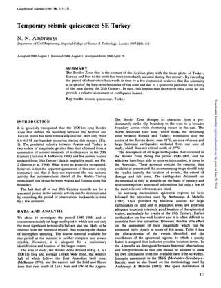
  • 1. Geophysical Journal (1989) %, 311-331 Temporary seismic quiescence: SE Turkey N. N. Ambraseys Department of Civil Engineering, Imperial College of Science & Technology, London SW72BU, UK Accepted 1988 August 1. Received 1988August 1; in original form 1988 April 26 SUMMARY The Border Zone that is the contact of the Arabian plate with the three plates of Turkey, Eurasia and Iran to the north has been remarkably aseismic during this century. By extending the period of observation backwards in time by a few centuries it is shown that this seismicity is atypical of the long-term behaviour of the zone and due to a quiescent period in the activity of the area during the 20th Century. In turn, this implies that short-term data alone do not provide a reliable assessment of earthquake hazard. Key words: seismic quiescence, Turkey INTRODUCTION It is generally recognized that the 1OOOkm long Border Zone that defines the boundary between the Arabian and Turkish plates has been remarkably inactive, with only three 6.6-6.8 M earthquakes occurring during this century (Fig. 1). The predicted velocity between Arabia and Turkey is two orders of magnitude greater than that obtained from a summation of seismic moments of earthquakes in the 20th Century (Jackson & McKenzie 1988) and the seismic hazard deduced from 20th Century data is negligibly small, see Fig. 2 (Burton et al. 1984). What is not so generally recognized, however, is that the apparent quiescence of this zone is only temporary and that it does not represent the real tectonic activity that accommodates almost all the Arabia-Turkey motion and part of that between Arabia and Eurasia along this boundary. The fact that all of our 20th Century records are for a quiescent period in the seismic activity can be demonstrated by extending the period of observations backwards in time by a few centuries. DATA A N D ANALYSIS We chose to investigate the period 1500-1988, and to concentrate mainly on large earthquakes which are not only the most significant tectonically but are also less likely to be omitted from the historical record, thus reducing the chance of incomplete sampling. The source material available for this period at the moment is neither complete nor always reliable. However, it is adequate for a preliminary identification and location of the larger events. The area of study, the Border Zone defined in Fig. 1, is a lo00 km long and average 150km wide zone, the western half of which follows the East Anatolian fault zone, (McKenzie 1976), and the eastern half the Fold and Thrust zone that runs south of Lake Van and SW of the Zagros. The Border Zone changes its character from a pre- dominantly strike-slip boundary in the west to a broader boundary across which shortening occurs in the east. The North Anatolian fault zone, which marks the deforming zone between Eurasia and Turkey, terminates near the centre of the Border Zone, near 41"E, an area of many and large historical earthquakes excluded from our area of study, which does not extend north of 39"N. The description of all large earthquakes that occurred in the Border Zone during the period 1500-1905, and for which we have been able to retrieve information, is given in the Appendix. These accounts contain the essential data available at present and the accompanying maps should help the reader identify the location of events, the extent of damage and felt areas. The earthquakes discussed are documented as fully as possible on the basis of primary and near-contemporary sources of information but only a few of the most relevant references are cited. In assessing macroseismic epicentral regions we have followed the procedure used by Ambraseys & Melville (1982). Data provided by historical sources for large earthquakes on land and in populated areas are generally adequate to permit relatively good location of the epicentral region, particularly for events of the 19th Century. Earlier earthquakes are less well located and it is often difficult to ascertain their true epicentres. However, this has little effect on the assessment of their magnitude which can be estimated fairly closely in terms of felt areas. Table 1 lists the characteristics of the events identified and the coordinates of the epicentral regions, to which a quality factor is assigned that indicates possible location errors. In the Appendix we distinguish between historical observations and interpretations so that one should be allowed to draw his own conclusions from the available facts if he so wishes. Intensity assessment in the MSK (Medvedev-Sponheuer- Karnik) scale is also based on the methodology used by Ambraseys & Melville (1982). The space distribution of 311 byguestonJune29,2014http://gji.oxfordjournals.org/Downloadedfrom
  • 2. 312 N.N.Ambraseys E .Erzurum .SlVOS T -38 42 e *Mardin A Mosu~ 36 44 0 200 Figure 1. Border Zone extends along strip covered by the grid. A: Arabian Plate; T: Turkish; E: Eurasian; and I: Iranian. EAF =East Anatolian Fault; NAF = North Anatolian Fault; FTZ = Fold and Thrust zone. Figure shows location of the three events during this century with M,2 6.6 in the Border Zone, i.e. of 1905, 1971 and 1975. intensity is intimately connected with the estimation of the size or magnitude of the earthquake, and magnitudes were assigned from the radius of perceptibility or any epicentral distance for a given intensity. Our sources of information Figare 2. Seismic risk map of eastern Turkey after Burton et al. (1984). Contours show the largest earthquake magnitudes expected over a period of 75 years predicted using Gumbel’sthird asymptotic distribution of extreme values of 20th Century data. The Border Zone covers the area where no data exists. are generally adequate to assess this, using the relationship derived for Turkey: M,= -0.53 +0.58(1,)+1.96X lOP3(r,)+ 1.83log (r,), (1) where rj are the available epicentral distances in km of intensity Zi. M, is then the average value of equivalent surface-wave magnitude determined from the different epicentral distances or isoseismal radii. Equation (1)is valid for shallow shocks and there is generally good agreement (f0.25)between M, determined from felt information in this way and M, determined from teleseismic surface waves (Ambraseys & Finkel 1987; Ambraseys 1988). Equation (1) was used, therefore, to estimate surface- wave magnitudes and select the larger events (M,? 6.6) in the Border Zone for the period 1500-1wO. For later events, magnitudes were calculated from instrumental data, and Table 1 lists the earthquakes identified as having M, 2 6.6. The overall error in assigning individual M, values for historical events is about 0.3 magnitude units, an uncertainty in M, comparable to that of 20th Century M, teleseismic determinations. This error arises mainly from uncertainties associated with the estimation of I,, and to a lesser extent from uncertainties in epicentral distance. However, the error in M, derived from more than four good individual intensity readings is usually not more than 0.3. We must add a word of warning: equation (1) represents the average attenuation of intensities in Turkey, derived from a large body of data which, however, contains a very small sample of M,26.0 earthquakes from the Border Zone and its extension into the Dead Sea system. There is some evidence byguestonJune29,2014http://gji.oxfordjournals.org/Downloadedfrom
  • 3. Temporary seismic quiescence: SE Turkey 313 Table 1. Large earthquakes (M, = 6.6) in the Border Zone 150-1988 Epicentre Date Time N E Q Ms 1" F QT Location 1503- - 1513- - 1573 C. - 1544 Jan 1648 Mar 31 1666Sep 22 1670 Aug 1 1685 Nov 22 1705 Jan 27 1715 Mar 8 1789 May 29 1796 Apr 26 1822 Aug 13 1866 Jun 20 1871 Mar 17 1872 Apr 3 1874 May 3 1875 Mar 3 1884Feb 10 1893 Mar 2 1905Dec 4 1971 May22 1975 Sep 6 - 2400 - 2300 o600 0905 2040 1400 0740 0700 2248 0500 2251 0704 1644 0920 - - - (37.4"-43.8') C 6.9- - 0 0 37.5 -36.5 B 7.4+ IX* 0 1 38.0 -37.0 B 6.7+ X* 0 2 35.5 -45.0 B 6.9- IX* 0 2 38.3 -43.5 A 6.7 X 0 3 37.0 -43.0 B 6.6 IX* 0 1 38.0 -42.0 B 6.6+ - 0 1 0 139.0 -41.0 B 6.7 - 38.7 -41.7 B 6.7 IX* 0 1 38.4 -43.9 A 6.6+ IX* 0 2 39.0 -40.0 B 7.0+ - 0 1 35.5 -36.0 A 6.6- VIII* 0 2 36.7 -36.9 A 7.4+ X 1 3 38.5 -40.9 A 6.8- IX* 0 2 38.0 -43.0 B 6.8+ - 0 1 36.4 -36.5 A 7.2- X 1 3 38.5 -39.5 A 7.1+ X* 2 2 38.5 -39.5 A 6.7 VII* 2 2 37.5 -42.5 B 6.9- VIII* 0 1 38.0 -38.3 A 7.1+ X 0 2 38.1 -38.6 A 6.8* IX* 1 2 38.9 -40.5 A 6.8* IX 3 3 38.5 -40.8 A 6.6* IX 3 3 Hakkari (?) Tarsus-Malat ya Zitun-Malatya Shahrizur Van-Hayotsdzor North Mosul Hizan Gonek Bitlis Van Palu Latakiya Aafrine Kulp Hakkari Amik Golii Golcuk Golii I Golcuk Golii I1 Siirt South Malatya Malatya Bingo1 (1) Lice (2) Notes: Q = estimated location accuracy, A: 10-40 km; B: 50-90 km; C: probably more than 100km. M, = estimated surface-wave magnitude from felt effects from equation (1). Plus/minus signs indicate estimates & F QT = overall quality of data. 0: poor; 1: medium; 2: good; 3: very good. probably underestimated/overestimated respectively. Asterisked values are from teleseismic data. = epicentralintensity (MSK). Asterisk shows maximum observed intensity. = historical/field evidence for faulting. 0: no evidence; 1: poor evidence, probably of secondary nature; 2: evidence in need of authentication; 3; good evidence. (1): Seymen & Aydin (1972); Ambraseys (1988). (2): Arpat (1977); Ambraseys (1988). that in these areas the attenuation of intensity may be somewhat slower, in which case, magnitudes derived from equation (1) may be overestimated. There is simply no comparable 20th-Century data from these areas that may be used to derive a strictly regional attenuation law. DISCUSSION Fig. 3 shows the location of all earthquakes identified in the Border Zone with Msr6.6 for the period 1500-1988, and Table 1 lists their main characteristics. This is a fairly representative sample of long-term activity, but by no means complete. The study of our source material suggests that for the whole zone and period studied, many moderate shocks (Ms<6.6) might not have been recorded, particularly in the Fold and Thrust zone. It is very probable, however, that any major or great earthquake has been noted, although not necessarily fully identified. It is reasonable to suppose, therefore, that the available data for the whole zone is incomplete for all magnitudes. Nevertheless, as can be seen by comparing Figs 1and 3, the available data are sufficient to establish beyond doubt that all of our 20th-Century seismicity comes from a quiescent period. From Fig. 3 we notice that the west part of the Border Zone, i.e. the East Anatolian Fault, is associated with relatively infrequent but large events, while the eastern part of the Zone, the Fold and Thrust zone, is characterized by more frequent smaller events and this behaviour continues SE into the Zagros. The first instance is typical of large strike-slip faults on which a fair proportion of dislocation takes place in a few large earthquakes that are easier to identify in the historical record (Sieh 1978). The second instance is also typical of regional thrusting, where deformation takes place in more frequent smaller shocks diffused within a broader zone (Jackson & McKenzie 1984, 1988); in this case, because of their smaller size, earthquakes are more difficult to identify and the historical record is more likely to be incomplete. This shows the need to separate deforming zones with different activities, in this case the East Anatolian Fault zone from the Fold and Thrust zone; each is about 500 km long, and they merge into one another at the end of the North Anatolian Fault zone near 41"E. The East Anatolian Fault starts from this point and extends SW all the way to Antakya, near where the 1796, 1822 and 1872 earthquakes suggest that it joins up with the Dead Sea Fault system. The East Anatolian Fault zone is marked by discontinuous segments showing Quaternary activity including the formation of closed depressions and sag ponds, such as the Golciik Lake (Hazar Golii) (Arpat & Saroilu 1972), localities associated with relatively large magnitude earthquakes in the period investigated as well as in earlier periods to be discussed elsewhere. Almost all of the few cases that allude to faulting, i.e. in 1822, 1872, 1874 and byguestonJune29,2014http://gji.oxfordjournals.org/Downloadedfrom
  • 4. 314 N. N. Ambraseys .Sivas .Erzururn .Erzincon -39 38 Figure 3. Distribution of earthquakes in the Border Zone during the period 1500 to 1988 (Table l), marked with year of occurrence. Size of dots corresponds to magnitudes6.0 and 7.0 respectively. 1905, are for events in this 100km wide zone that shows remarkably low background seismicity, not only during this century but also in earlier times. The East Anatolian Fault is clearly sinistral in its sense of displacement (McKenzie 1976) and the deformations associated with earthquakes in this zone seem to occur along the entire length every few hundred years during relatively short paroxysmal periods of large events. From Fig. 3 and Table 1we notice that the first paroxysm in our period of observations ended in 1544 and the second started after two and a half centuries of relative quiescence in 1789. This period of low activity seems to be genuine and is in many respects similar to that being experienced by the zone during this century. In the following 116 years, that is between 1789 and 1905, a series of relatively large earthquakes began, alternating between the two ends and gradually converging to the middle of the East Anatolian Fault zone. East of 41"E the tectonic style of the Border Zone distinctly changes into a broad zone of compression that merges into the Zagros and Caucasus zones. The width of the Fold and Thrust zone is difficult to define and the available sample of its historical seismicity is likely to be incomplete. More work is undoubtedly needed to retrieve additional information and to refine important details over a much larger area before more can be said about the long-term interaction of the main tectonic elements in this part of the Eastern Mediterranean. However, the very preliminary evidence presented here demonstrates that the 20th-Century activity of the Border Zone is associated with a quiescent period atypical of the long-term seismicity of the region. The same evidence suggests that on large strike-slip faults much of the slip may be associated with infrequent clusters of large shocks and relatively long periods of quiescence. It also suggests that in thrust zones much of the deformation may be taken up aseismically with only a small part being associated with medium magnitude events, which are more difficultto sample from the historical record. It is expected that overall plate motions over the last few decades should not differ significantly from those over the past few million years. However, this does not mean that the associated seismicity should be constant with time. Rupture processes that control the generation of earthquakes do not depend solely on plate motions. They depend aiso'on the capacity of the crust to store and release potential energy through flow, creep and fracture, which is highly variable. Large events on a given fault segment are likely to have repeat times of the order of hundreds of years and the long-term data from the Eastern Mediterranean region show conclusively that the past 88 years provide a very incomplete sample. Consequently, it is simply not logical to ignore the possibility that all of our observations may be for a quiescent period in the seismic activity of a region. This is one of the alternatives that must be borne in mind when making an assessment of seismicity, and this is the chief reason why statistics based on short-period data alone do not provide a reliable assessment of earthquake hazard. Historical evidence for the Eastern Mediterranean shows that the seismicity of the East Anatolian Fault zone is in some ways similar to that of the Dead Sea system, where infrequent large earthquakes (Ambraseys & Melville 1988) byguestonJune29,2014http://gji.oxfordjournals.org/Downloadedfrom
  • 5. Temporary seismic quiescence: SE Turkey 315 occur throughout its length, but the system has remained almost aseismic during this century. ACKNOWLEDGMENTS I thank Dr C. Finkel for her assistance in the retrieval of historical data and helpful comments and discussions. I also thank K. Bardakjan, B. Johnson, I. Karcz, P. Pantelopoulos and J. Vogt for supplying me with information and drawing my attention to unpublished documents. I am grateful to J. Jackson for his comments on the manuscript. This research was supported by the Natural Environment Research Council grant for the study of the long-term seismicity of the Eastern Mediterranean Region, and is Contribution ESEE Research Report No. 88/6/Feb. 1988. REFERENCES Amantos, C. I., 1932. Vrachea Chronika, in Mnimeia Hellenikis Historias, Vol. 1, p. 61, Akademia Athenon, Athens. Ambraseys, N. N., 1988. Engineering seismology, Mallet-Milne Lecture, Special Issue, Earthquake eng. struct, dyn., 17, 1-106. Ambraseys, N. N. & Finkel, C. F., 1987. Seismicity of Turkey and neighbouring regions 1899-1915, Annales Geophys., 5b, Ambraseys, N. N. & Melville, C. P., 1982. A History of Persian Earthquakes, Cambridge University Press. Ambraseys, N. N. & Melville, C. P., 1988. An analysis of the Eastern Mediterranean earthquake of 20 May 1202, in Historical Seismograms and Earthquakes of the World, pp. 187-200, ed. Lee, W. H. K., Academik Press. Arpat, E., 1977. 1975 Lice depremi, Yeryuvari ve Insan, 2, 15-28, Ankara. Arpat, E.& Saroglu, F., 1972. The East Anatolian fault system, Bull Miner. Res. Explor. Inst. Turkey, no. 78, pp. 33-39, Ankara. Avril, le Pere, 1692. Voyages en divers etats d’Europe et d’Asie efc., Paris. Barbaro, D., 1842. Storia Venrziana dell anno 1512 a1 1515 etc., Archivo storico Italiano, Vol. 7, Rome. Ba5bakanlik Archives (various documents under MD.36/250: 4 Muharram 987 et fol)Istanbul. Burton, P. W., McGonigle, R., Makropulos, K. C. & User, S. B., 1984. Seismic risk in Turkey, the Aegean and the eastern Mediterranean, Geophys. J. R. astr. soc., 78,475-506. 701-726. Cevdet, 1309/1893. Cevdet tarihi, Istanbul. Consular Archives: Foreign Office, London (F.O. 195/39.1796 Aleppo, Istanbul, Alexandria; F.0.78/110-112.1822-3 Aleppo, Istanbul, also F.O. 195/112; also for other years under Levant); India Office Records, London (I.O.SP.105/140. 1822-4, Aleppo, Antioch, Suedia; also for other years); Archives Nationales, Paris (A.N.B1/1042/169-204.1822 Aleppo, Saida, Levant; also for other years). Conybeare, F. G., 1913. A catalogue of the Armenian manuscripts in the British Museum MS:BM.Or5459, note f.228, London. Fiey, J. M., 1965. Assyrie chretienne, Vol. 2, Impremerie Catholique, Beyrouth. Giizelbey, C. & Yetkin, H., 1970. Gazianfep ser’i mahkeme sicillerinden ornekler Vol. 140, 57-58, Gaziantep. Hakobyan, V. A., 1951-1956. Manr zharnanakagrut’yunner Xlll-XVIII DD, Erivan. von Hammer, J. Geschichte des Osmanischen Reiches, 10 Vols, Pest. Jackson, J. A. & McKenzie, D. P. 1984. Active tectonics of the Alpine Himalayan belt between western Turkey and Pakistan, Geophys. 1. R. astr. Soc., 77, 185-264. Jackson, J. A. & McKenzie, D. P. 1988. The relationship between plate motions and seismic moment tensor, Geophys. J . , 93, 45-73. Ibn Iyas, M. B. A., 1311/1893. Bada’i ‘al-zuhurfiwaqa’i’ al-duhur, ed. Bulaq. Incicean, Gh., 1822. Sforgrutiwn hin Hayastaneayc; Mec Hayk, Kinneir, J. McD., 1818. Journey through Asia Minor, London. Longrigg, S. M., 1925. Four Centuries of Modern Iraq, Oxford. McKenzie, D. P., 1976. The East Anatolian Fault; a major structure in eastern Turkey, Earth planet. Sci. Lett., 29, Olivier, G. A., 1807. Voyage duns l’empire Othoman etc., 3 vols, Oskean, H. 1953. Taron-Turuberani vank’erd, Vienna. Perrey, A. 1875. Note sur les tremblements de terre en 1871 etc., Mem. Cow. Acad. Bruxelles, 24, 1-143. Press reports: various; most important, Istanbul (Levant Herald, Stamboul, Neologos, Ikdam, Sabah), Izmir (Amaltheia, Courier de Symrne), Paris (Moniteur, Journal des Debuts, Nouvelles Missions du Levant). Rebeur, E., 1895. Horizontalpendel-Beobachtungen auf der Kaiserlichen Univeritats Sternwarte zu Strassburg 1892-1894, Beitr. z. Geophys., 2, 211-534, Leipzig. Riggs, H. H., 1909. Earthquake Notes, Euphrates College unpublished reports, Harpoot. Sa’igh, S., 1923. Tarikh al-Mausil, Cairo. Seyman, I. & Aydin, A,, 1972. The Bingo1 earthquake fault and its relation to the North Anatolian fault zone, Bull. Miner. Res. Explor. Inst. Turkey, 79,1-8. Sieherg, A., 1932. Untersuchungen iiber Erdbeben und Bruch- schollenbau im ostlichen Mittlemeergebiet; Denkschr. Mediz.- Naturw. Gesell. z . Jena, 2, Jena. Sieh, K. E., 1978.Prehistoric large earthquakes produced by slip on the San Andreas fault at Pallett Creek California, 1. Geophys. Res., 83, 3907-3939. Stepanian, V., 1942. Istoricheskii obzor zemletriaseniiakh v Armenii i v prilegaiuscchikh raionakh, Izdatel. Arm. F.A.N., Biuro Antiseismicheskogo Stroitelstva, Erivan. Theatrum Europaeum, 1617-1721. ed. Abelin, J. B. 21 vols, Frankfurt. Thierry, J. M., 1969. Monasteres Armeniens du Vaspurakan, Revue Etudes Armen., 6, 141-180. Thierry, J. M., 1972.Monasteres Armeniens du Vaspurakan, Revue Etudes Armen., 9, 137-178. Thierry, J. M., 1983. Notes d’un voyage archaeologique en Turquiw orientale, Handes Amsorya, 97, 379-406. al-’Umari, c.1800. Yasin al-Khatib, AI-athar al-jaliyafi ’I-hawadith al-ardiya, MS Iraq Academy, Baghdad. Venice. 189- 193. Paris. APPENDIX This Appendix contains descriptions of earthquakes identified in the Border Zone during the period 1500-1905 with M,r6.6. Some of these earthquakes are described in greater detail than others; the purpose of this is to highlight important aspects of an event and illustrate the nature of the information that can be found in historical sources. Figure 4 shows the localities mentioned in the Appendix for events that do not merit construction of a separate map. Reference to maps relating to specific earthquakes should indicate the method used to assess macroseismic epicentres and equivalent radii of intensity for use in equation (1) and illustrate the basic pattern of the spread of felt effects. Isoseismals are of a generalized nature and they are drawn on the basis of the available data which are more numerous than shown on intensity maps. Place-names are spelt as given in contemporary sources and they may not be in use today. For the general location of the events that follow, see Figs 3 and 4. 1503; Hakkari Information about this earthquake comes from a late 18th century Arab history. It states that in W8AH the city of Mosul, along with Tabriz and Azerbaijan, and the city of byguestonJune29,2014http://gji.oxfordjournals.org/Downloadedfrom
  • 6. 316 N.N. Ambraseys 36 I40 - _ I .Sivas I I _ _ .Erzurum 44 I I - _ Hacin EIbistan 'Zitun 'Maras .Aintab Jeble 1 'Divrigi .Bucak Lattakiya Figure 4. Location map of places mentioned in the Appendix. I I _ _ Ahlat, were shaken by an earthquake which destroyed some houses. The sites said to have suffered some damage are situated about 360km apart, around the inaccessible and sparsely-populated district of Hakkari, southeast of Lake Van. If the statement is correct-and we have no earlier source-it implies that the shock was of considerable magnitude. al-'Umari (c. 1800). l5W;Tarsus-Malatya We learn from a contemporary diary that in the first months of 1514 the Ottoman Sultan Selim I arrived in Konya where he found the pestilence raging and the towns of Tarsus, Adana and Malatya almost totally destroyed by an earthquake. The shock apparently affected the province of Cilicia, which in the 16th Century extended SE of Kayseri and along the south bank of the JCizilirmak river. Thus the earthquake must have occurred before 1514, and should have destroyed a large area stretching for at least 340 km along the Border Zone. This may be the earthquake felt in Lower Egypt on 1513March 28 which, it is said, affected the region of Rum with its centre at Sivas: without further details the account is insufficient to indicate the precise date and area over which the event was felt. It is of interest, however, that sometime in the 15th or early 16th Century the river Berdan, that flowed through Tarsus, seems to have changed its course, and since that time it has flowed outside the town, further to the NE and SE. The remoteness and large extent of the area destroyed, as well as the survival of this information in a contemporary occidental source and allusions of damage to Armenian settlements around Hacin, suggest the comparative gravity of the event. Barbaro (1842, vii.1061); Ibn Iyas (1311/1893, i.278). .R.Hormiz Sanjbulaq' .Sinjar .yosul Nmeve I .Sanjaq _ - I Shahrizur Sharqat Gulanbar, 0 200 lS44Jan; Zitun-Malatya Contemporary sources describe briefly this large earthquake, which occurred in the same region as the earthquake of 1513, destroying a relatively large area. From a Greek marginal note we learn that the whole East was shaken by a great earthquake as a result of which Zitun was devastated. An Armenian colophon written in Sivas adds that one part of Zitun was destroyed by the shock, and the rest of the town was overwhelmed by the collapse of the mountain on which it was built. Half of Elbistan was also destroyed, and shocks continued for six months. Heavy damage apparently extended to Aintab and in the region of Maras, where the Sajur intake for the water supply of Aleppo was seriously damaged. Although the exact extent over which the shock was felt is not known, there is no doubt that this was large and included Eastern Anatolia and Syria, from where it was also reported. Amantos (1932, 61); Hakobyan (1951, 171). c. 1573; Shahrizur A contemporary order from Istanbul to the Ottoman provincial authorities in Mosul informs us that as a result of an earthquake in the district of Shahrizur builders and stonemasons were sent from Diyarbakir to undertake reconstruction and repair of the fortress of Giilanber, which was almost totally destroyed. This document, which gives some details of the repair work to be done, provides only a terminus ad quem of early 1579: most probably it refers to the earthquake of 1573, mentioned by later sources, that byguestonJune29,2014http://gji.oxfordjournals.org/Downloadedfrom
  • 7. 39 Temporary seismic quiescence:SE Turkey 317 4443 I I --I 38 I -1- 0 10 5 0 Figure 5. Epicentral region of the Van-Hayotsdzor earthquake of 1648. destroyed a large number of houses and buildings in Mosul and in the Sanjaq region. The shock was severe in other parts of Iraq and in Azerbaijan. The extent of the area over which this earthquake caused damage suggests a relatively large event with an epicentre somewhere between Mosul and Giilanber. Bqbakanlik Archives (MD 36/250); Sa’igh (1923); Longrigg (1925). 1648 March 31; Van-Hayotsdzor This is a relatively well-documented damaging earthquake in the region of Van (Fig. 5). To the north of the HoSap river the densely-inhabited region of Van was almost totally destroyed: the Armenian monasteries and cloisters of Aleruvanqer, Ardjakuvanq, Berdak, Kendenanits, Krnkuv- ank, Kurubash, Noragivt, Salnapativanq, Srquvank, Susans and Varang were either destroyed or damaged so badly that they had to be rebuilt or abandoned. The town of Van was also damaged; the walls of the lower citadel from the Tabriz gate to the Haniburts quarter (?) collapsed, together with houses and a number of churches in the town and immediate vicinity. The shock caused twelve springs of water in Avants to dry up, and at Noragivt triggered a landslide that carried away and destroyed the village and nearby cloister. Damage was equally heavy and more extensive to the south of the HoSap river in the less densely populated valley of Hayotsdzor: here, all the cloisters were ruined and the monsatery of Hegavanq was destroyed. At Ab-i Ghner- ham, near Hogeatsvanq, landslides dammed the stream and caused the abandonment of a number of water mills; rockfalls killed a number of people in this region. At Hermerugivt the ground was deformed and slumped in places creating ponds, while at Eghnaberd and lower Pagah springs dried up causing six water mills to be abandoned and 1648 the inhabitants to remove to Karsik. Damage was reported from as far as Ardzgue, from the district of Shatakh, from Mehmedik, and probably from Seynis and Satmanis. The shock was felt strongly in Tabriz and it was perceptible in other parts of Armenia. Aftershocks continued for about three months. Thierry (1972); Ambraseys & Melville (1982). 1666 September 22; north of Mosul News of the disaster was reported from Aleppo where the shock was apparently felt, and was published with variations in a number of European news-sheets. In Mosul and its surroundings the shock was particularly strong and “threatened to reduce Nineveh to a heap of rubble”. Many houses were destroyed in Mow1 and also, allegedly, the cathedral that housed the tomb of Nebi Yunus (St Jonah). Monasteries to the north of the town were ruined, including that of Raban Hormiz: an inscription refers to the reconstruction of its north walls after the earthquake. In addition, five towns and 45 villages, the names of which are not given, were totally destroyed, and damage extended to Sinjar and Sharqat. It is said that as a result of the earthquake “four great mountains were raised up from the ground and thrust against each other, reducing themselves into dust”, an allusion, perhaps, to landslides. Destructive shocks continued for several days. It appears that the earthquake was felt strongly in Van and Tabriz. However, because of dating problems, it is not certain whether this was the effect of the earthquake of 1666 September or of the larger earthquake of 1666 November 14 that affected the region between Erzincan and Van. Although the size of the epicentral area of the Mosul earthquake is not yet clear, the relatively large number of villages destroyed in such a byguestonJune29,2014http://gji.oxfordjournals.org/Downloadedfrom
  • 8. 318 N. N. Ambraseys sparsely-populated region, and the great distance at which the shock was felt, are facts that imply a relatively large magnitude event. Theatrum Europeum (1617-1721, x.i.445); Hammer (1827-1835, vi.190); Fiey (1965). 1670 August 1; Huan We know that in 1670 the region between Hizan and Siirt, SW of Lake Van, was ruined by an earthquake as a result of which a number of people abandoned their villages. Armenian colophons refer to this event, which was felt in Van, in the district of Taron, and throughout Vaspurakan, causing great concern but no damage except to the east of Lake Van where a part of the Varag mountain fell into the valley blocking the river flow. These notes record other strong shocks that followed on August 2, 9 and 18, but give no details. Riggs (1909); Conybeare (1913); Hakobyan (1951- 1956). 1685, November 22; Gonek This earthquake was experienced by a European traveller and it is reported in Armenian notices. The shock occurred a little before midnight and caused severe damage to villages about 50 km SW of Erzurum, where the ground was also deformed. In Erzurum, successive shocks were felt for 15min and aftershocks, described as violent, continued for 8 days. There is no evidence that the earthquake caused any damage to the north or east of Erzurum, but it was violent to the south, and particularly in Van. The location of the epicentral area is not known but it must have been somewhere along the Erzurum-Diyarbakir road, 8-10 leagues (i.e. 50 km) from Erzurum, past the Gonekale pass in the Sushar district, that is somewhere between Bingo1 and Karliova. Avril (1692); Riggs (1909); Hakobyan (1951- 1956). 1705 January 27; Bitlis This was a destructive earthquake in the district of Baghesh that caused great loss of life. Details are lacking, but the available information implies severe localised destruction near Bitlis. Damage extended to the monastery of Surp Karapet, northwest of Mu?, where many buildings collapsed. The shock, which was violent in Van, was preceded and followed by strong shocks felt throughout the district of Vaspurakan. Oskean (1953); Hakobyan (1951- 1956);Thierry (1983). 1715 March 8; Van A severe earthquake occurred at dawn in the region of Mahmatan, SE of Van. It destroyed villages in the Mehmedik plain, killing a considerable number of people. At Hoaap the walls of the fort were ruined and at Satmanis there was damage but no casualties. The earthquake caused the collapse of the dome of the church of St. Bartholomeus at Deir and the ruin of the fort at Sarai. In Van the shock caused some damage and few casualties, while in Ercis, on the north shore of Lake Van, the dome of the church collapsed causing casualties and there was other damage. Apparently the earthquake caused widespread damage to public buildings, religious monuments, bridges and private property, that took a long time to repair. Thierry (1969); Ambraseys & Melville (1982). 1789 May 29; Palu This earthquake seems to have been a catastrophic event that affected the region of Palu, just south of that devastated by the North Anatolian earthquake of 1784July 18.The only primary source of information for this event is an official dispatch received in Istanbul from the district of Palu informing the authorities that an earthquake had completely destroyed a tract of land “21 hours of march long and 21 hours of march wide”-that is an area of a radius of about 75 km-within which 51OOO people were killed. This event is also registered in the almanac (takvim)for 1203AH, and dated 4 Ramadan. A less precisely dated primary source is an Armenian marginal note written at Divrigi late in the 18th Century, which says that there was an earthquake in Tivrik and Malatya in 1229AA that destroyed many places and killed a large number of people. Since there is no other note of an earthquake in 1239AA, the year given for the event in the Armenian source may be in error by exactly 10 years. Although details about this earthquake are lacking, it is clear that it was a major event in the Border Zone. Travellers in the decades following the event noticed the ruinous state of the district, and particularly of Palu, which they attribute to the constant earthquakes in the region. Also, Armenian sources refer to a destructive earthquake in the region which was felt at Erzurum, but this may be an altogether separate event. Kinneir (1818); Incicean (1822); Stepanian (1942). 1796 April 26, Lattakiya A destructive earthquake in the Sahel district of Lattakiya on the Syrian littoral. The shock occurred in the morning and lasted for about 1min, almost totally ruining the coastal plain between Jeble and Bucak. Most of the houses collapsed in Jeble, and water wells caved in and became dry. Most of the miri villageethose belonging to the Ottoman state-in the Nahr al-Kebir plain, an area about 40 km long and 15km wide, were ruined. In Lattakiya, 1500 out of a population of 5000 were killed; one-third of the town collapsed and the remainder was damaged. The old castle, minarets, watchtowers and large buildings fell down. In the port area the tobacco customs-house, one of the most solidly-built structures, fell in and killed 400 people. It is said that the shock raised the surface of the ground several tokes, but this may be an exaggeration. The earthquake had no effect on the sea, which remained calm, but it did cause the temporary drying-up of streams NE of Lattakiya, probably due to landslides. We do not know how far inland the shock was felt, but we do know that it was strongly felt at Saida, 230 km away to the south. Aftershocks continued to be felt for two months, preventing people from returning to their villages. Consular Archives; Olivier (1807); Cevdet (130911893, vi.222). byguestonJune29,2014http://gji.oxfordjournals.org/Downloadedfrom
  • 9. Temporary seismic quiescence: SE Turkey 319 'Merzi f on I I _ _ 'Tokat I I _ - I I _ - 0 200 182238 32 Figure 6. Felt area of the Aafrine earthquake of 1822. Lower isoseismals are approximate. Inset shows area in Fig. 7. Compare with Sieberg (1932, 195). Antakya in Turkey and Aleppo and Han Sheikhun in NW Syria, killing a very large number of people. Slight shocks, reported mainly from Aleppo and Antakya, began on August 5 and continued intermittently until August 12, but since they were like many others which had been experienced in the past, they caused no alarm to the inhabitants. At 8h 10m pm on August 13 a strong shock was felt in the region between Lattakiya, Aleppo and 1822 August 13; Aafrine This earthquake was the largest in the Border Zone in the last five centuries and will therefore be described here in some detail. The earthquake was felt from the coast of the Black Sea to Gaza (Fig. 6) and it was followed by an aftershock sequence that lasted almost 24 yr. The shock almost entirely destroyed the region between Gaziantep and byguestonJune29,2014http://gji.oxfordjournals.org/Downloadedfrom
  • 10. 320 N. N. Arnbraseys Figure 7. Epicentral area of the Aafrine earthquake of 1822. Contours in metres. Star shows location of adopted epicentre. Antakya: this caused considerable concern and warned the people of what was to follow. The main shock happened 30min later in three phases lasting altogether 40 s. A flash of light was seen in the sky over Aleppo, Antakya, Suaidiya and Iskenderun. After a short pause, the main shock was followed for about 8min by successive shocks, about 30 in all, each of short duration but of damaging intensity; in Aleppo, Antakya and Aintab these were as strong as the main shock and completed the destruction and caused the bulk of the loss of life. The most northerly part of the area destroyed was that of Gaziantep and Atmanlu (Fig. 7). The chief town of Aintab was almost completely destroyed: most houses collapsed and the remainder were rendered uninhabitable; mosques, medreses, the old castle-already in ruins-part of the old aqueduct and the surrounding villages were destroyed with byguestonJune29,2014http://gji.oxfordjournals.org/Downloadedfrom
  • 11. Temporary seismic quiescence: SE Turkey 321 hans and souks, including that of the perfume-makers, were ruined. The al-Fanig gate collapsed and the Hanaqa al-qadim was damaged. The houses of all the Europeans, both public agents and private individuals, were entirely destroyed, as well as all Christian convents and other buildings. The large building that had been the British consulate for 230 yr was ruined, although not entirely fallen in. In general, the upper part of the city of Aleppo and the European sector suffered less than the rest, but damage was so widespread that most European merchants removed to Cyprus after the earthquake. It is said that before the earthquake the temperature of well water had perceptibly increased and that after the earthquake the flow of the Quwayq river was arrested for many hours near Hailan, where there was much damage. The town of Antakya and its surrounding villages were ruined. The town was evacuated and its inhabitants camped in the open fields for a long time. Many small settlements in the upper and lower Quseir area were razed to the ground. The shock did not cause any extensive ground ruptures near Antakya, although crevasses were to be seen in the low ground near the town and in the Amik valley. Water issued out of many of these, but soon subsided, clear indication of the liquefaction of the ground. Beilan was heavily damaged, presumably without casualties, but some of its more substantial buildings were almost totally destroyed. At Iskenderun the shock was strong enough to destroy a number of houses and to cause extensive liquefaction along the coast and in the plain at the foot of the Gavur mountain where areas of cultivated land turned into marshes, the ground water rising permanently to well above ground level and inundating a number of settlements. At Payas damage was more serious-some houses near the old port sunk into the ground but most of the people escaped unhurt. Damage along the Syrian coast was also serious. One-third of Lattakiya was again destroyed and one-third damaged. Not a single warehouse in the harbour area was considered to have escaped; the convent and the French consulate were damaged and 48 people were killed and 20 injured. The town was completely evacuated. In the Marina, about 15km from the town, the ruined fort, the mosque and the large han rebuilt after the 1796 earthquake collapsed and houses and stores were considerably damaged. Jeble was more heavily damaged and people were killed. The great mosque that housed the tomb of Sufi Ibrahim b. Adham collapsed. Damage was also reported from Markab where, among other buildings, the castle of the Crusaders on the mountain partly collapsed. Damage extended to the region of Adana and Misis where villages along the road to Antakya were ruined. It is not known whether this was due to the severe shaking or to the widespread liquefaction of the ground which was reported from the low-lying plain of the Ceyhan river. Kozan, Maras and Nizip also seem to have been affected, although contemporary reports seem to exaggerate the effects of the 1822 earthquake which they confound with that of 1811, a much smaller event which caused considerable damage to these towns. Further away, the shock was strongly felt in Tarsus. At Homs it caused unspecified damage while in Tripoli and its dependencies it was violent and caused damage in places. great loss of life. The villages of Sa&e, Araplar, Burc and Kehriz were destroyed and many people and animals were killed, Survivors sheltered in tents and huts outside the villages for a long time after the earthquake. Damage was equally heavy in the districts of Shikaghi and particularly of Jum and in the settlements along the Aafrine river, where it is said that the flow of water in streams was reversed for some time before they dried up, while elsewhere the flow of stream water temporarily increased. The ground opened up for some distance as a result of the earthquake; the Orontes river overflowed its banks destroying bridges and embankments so that cultivated land was flooded, and the river altered its course permanently. The exact location of these changes is not known, but may have been where the routes from Antakya and Lattakiya to Aleppo cross the Orontes, that is between Hadid and Jisr as-Shugr, rather than further north. The small town of Kilis was destroyed with loss of life-it is said that there existed an inscription on the Cekmeceli Cami in the town that commemorated the event. Harim and Armenhaz, further to the south, were totally destroyed, and Darkush was ruined partly by the shock and partly by landslides that carried away part of the village. Near here, at an unknown locality, a landslide temporarily blocked the Orontes river in the valley to the north towards Hadid. South of Darkush narrow gorges of the Orontes collapsed and the village of Jisr as-Shugr was entirely destroyed with loss of life. Individual farmhouses and small settlements in the area of Jur were razed to the ground. Han Sheikhun, Er Riha, Idlib and particularly Maarat were almost completely ruined but the loss of life was not great. Houses collapsed in these places but large buildings, although shattered, were left standing, except in Maarat where they were brought down by aftershocks which also crevassed the banks of the Orontes. It is said that damage extended to Hama and that the town suffered as much as Aleppo. Aleppo, a city built almost entirely of stone, and with about 40000 houses containing a population of about 200000 including the suburbs, was ruined. Statistics for earthquake casualties are generally reckoned to be grossly exaggerated; however, the best estimate of casualties in Aleppo is that made by European consuls sometime after the event, who reckon that 7000 people were killed within the walls of the city (the gates of which were shut for the night at the time of the earthquake), and about 200 in the extramural part of Aleppo where most people were able to escape into the gardens. The shock, and its many destructive aftershocks in the ensuing lOmin, killed 5300 Arabs and Turks, including Sheikh Abdallah ar-Razah, a religious leader of Aleppo. The Jews suffered most, as their quarters were badly built and with very narrow lanes between the houses; out of a total of about 3000, 600 were killed, mainly women and children. The Armenian community lost about 1400 and the very much smaller European community lost 13 including the Grand Dragoman and the Austrian consul who was killed in the street by an aftershock occurring a few minutes after the main shock. Indeed, most of those killed within the walls of the city perished in the narrow lanes trying to escape during this aftershock period. The walls of the citadel were ruined but the 18m high watchtower and the nearby 86m deep draw-well were not affected. Many byguestonJune29,2014http://gji.oxfordjournals.org/Downloadedfrom
  • 12. 322 N . N. Ambraseys The earthquake was reported from Beirut and Sidon, and from Damascus where people spent the night camping in the open spaces and outside the city which is said to have suffered slightly. In Jerusalem and Gaza to the south, and in Trabzon, Tokat and Merzifon to the north, the shock was strongly felt; it was not, however, reported in Alexandria, contrary to later statements that confuse this place with Alexandretta (Iskenderun). The earthquake was felt throughout the island of Cyprus, particularly at Kition and Larnaca where it caused some concern, but it was not so strong at Limassol. Northeast of Aleppo, at Urfa and along the Euphrates, there is some evidence that both the main shock and the aftershocks of 1822 August 15 and 1823 June 30 were felt and caused some damage. Contemporary reports also suggest damage at Diyarbakir and add that the earthquake was perceptible throughout Mespotamia (Jazira). The main shock was felt by ships sailing between Cyprus and Lattakiya and halfway between Alexandria and Cyprus. There is no evidence that this event was associated with a seismic sea-wave in the eastern Mediterranean or with an abnormal fluctuation of sea-level. Destructive aftershocks occurred in 1822 August 15 and 23, September 5 and 29, October 18 and 1823 June 30, the sequence terminating in 1824 March. The total number of people killed in this earthquake is impossible to determine. Contemporary estimates vary between 30000 and 60000,while more sober estimates put the total at 20000 dead and as many injured. Internal evidence does suggest, however, that the destruction and loss of life may have been very great. For example, although the number of people killed in the Gaziantep region is not known, the fact that the authorities issued instructions after the earthquake to regulate the handling of inheritance cases that arose in the district is itself an indication of the gravity of the situation. A further indication is that Gaziantep, Aleppo and other affected districts were relieved from the obligation to provide supplies for the Ottoman troops in the area, the plea for assistance from the Ottoman Porte being met with the rejoinder that there was “no other solution than enduring God’s decree”. It is said that the loss of life amongst the Armenian population in Aintab, one-third of the total, was so great that there were no priests left to officiate at burials and that the property left by those killed without surviving relatives to inherit, and which passed to the state, was very great. At Kilis it is said that the loss of life was so great that there were too few people to pick the olive harvest that year. The serious damage caused to the city of Aleppo had social implications. Many left and settled elsewhere, while business life was SO much affected that the French consul requested permission from Paris to remove his office to Beirut; he was only one of the Europeans who never returned to Aleppo after the earthquake. Some built timber-framed houses outside the walls on a site that eventually became the al-Kattab suburb, and where permission was also given for a church to be built. The extent of damage to that part of the city outside the walls is reflected in the fact that the moat was soon filled with the rubble from the houses thrown down in the earthquake. One of the reasons for the decline of Aleppo as a commercial centre in the early 1800s was the earthquake of 1822 and its long and damaging aftershock sequence. For many years after the earthquake only a few huts were to be seen on the ruins of villages further south, along the Orontes river at Darkush and Jisr as-Shugr. Much of the news about the earthquake originated shortly after the event from consular correspondence and letters from missionaries published in the European press. Communications with the stricken area were made difficult not only by the civil war raging at the time but also by the restrictions imposed on movements as a result of the cholera epidemic that spread into the region from Mespotamia. To make matters even worse, Bedouin descended on Aleppo and the east bank of the Orontes from the Syrian desert and plundered the ruins. Marauding tribesmen and renegade soldiers made the countryside unsafe for a number of years after the earthquake. News of the disaster reached the Ottoman Porte on August 28, but was kept from the public during the festivities of the Feast of the Sacrifice. Except for the temporary relief from taxation mentioned above, no evidence has yet been found that the affected areas received any outside assistance. The Levant Company raised subscriptions in London for the sufferers, but only a small part of this was spent since the Porte did not, on this occasion, permit its subjects to be relieved by a foreign nation. The importance of the earthquake of 1822 lies not only in the fact that it was one of the largest shocks in the Eastern Mediterranean region, but mainly that it occurred in an area that has been totally quiescent during this century. Consular Archives; Press Reports; Giizelbey & Yetkin (1970). 1866 June 20; Kulp The facts about the earthquake of 1866 June 20 in the district of Kulp are imperfectly known. News of an earthquake felt in Erzurum on May 12 that caused damage somewhere in the district was reported by the Russian consul and carried by the press without much detail. Sometime later the press reported another violent earthquake in Erzincan, Varto and Kigi that caused damage in Mu$ and was felt in Erzurum too. Apparently, the destruction caused by this second shock was serious enough for the Erzurum authorities to dispatch a relief mission into the stricken area, which is not mentioned by name. Later reports from Diyarbakir, however, identify part of the region affected, which they say was between the rivers Tigris and Euphrates, not far from the town. The size of the area destroyed, and within which the ground opened up extensively, is given by different sources as either of a radius or of a circumference of 30 leagues (145km). Additional published and unpublished information retrieved recently shows that the first shock, felt in Erzurum on May 12 (but which is usually confounded with that of June 20), was a relatively small earthquake that originated, in fact, from the northern part of Caldiran, to the east of Erzurum, where it caused serious but localised damage (Figs 8 and 9). The second and much larger earthquake of June 20 affected the remote districts of Sasun, Capakqur, and particularly Kulp where it seems to have caused great loss of life. It is said that many, mainly Kurdish villages, perched byguestonJune29,2014http://gji.oxfordjournals.org/Downloadedfrom
  • 13. Temporary seismic quiescence: SE Turkey 323 'Kors I I _ _ 40 I- -y&-- - - -1 .Varto 0 100 I I I --I- _ 318 42 ,Mosul 36 1866 Figure 8. Felt area of the Kulp earthquake of 1866. Inset shows region in Fig. 9. Figure 9. 1866 41 Epicentral area of the Kulp earthquake of 1866. Star shows approximate location of adopted epicentre. byguestonJune29,2014http://gji.oxfordjournals.org/Downloadedfrom
  • 14. 324 N.N . Ambraseys on steep slopes, were totally ruined and some were never rebuilt. Damage was apparently heavy in the Sasun district from where some of the Armenian survivors emigrated to Harput and Mug. No relief could reach these areas, which even under normal conditions had been unsafe to enter. The nearest point to which relief supplies could be sent safely was Hani and its nearby villages, where damage was also serious but without many victims. Germav and Mug were also damaged with some casualties, but details are lacking. The church of St George of the Armenian monastery of Surb Karapet was damaged and there was some destruction at Simsor and in the villages of the Capakcur district. On a cursory field trip to the area between Mu3 and Harzo in late 1966 we could find no one who knew anything about this earthquake and no other evidence for its occurrence could be found in local sources. Press Reports; Riggs (1909); Thierry (1983). 1871 March 17; Hakkari This was a comparatively large shock about which we know very little: it had an epicentre somewhere in the Hakkari district and was felt throughout Armenia and Kurdistan. The shock was strongly felt in many places as far apart as Dogubayazit, Erzurum and Mu$, and particularly in Van and Bagkale in Albag. The shock destroyed a bridge on the Euphrates (?) and many villages whose locations are not known. Press Reports; Perrey (1985). 38 1872 April 3; Amik Golii This was a large earthquake. It occurred at 7 h 40 m am and affected the lower reaches of the Orontes where the river empties into the Mediterranean. The shock almost totally destroyed Antakya as well as its seaport of Suaidiya and it was felt throughout the Eastern Mediterranean, from Rhodes to Diyarbakir and from Konya to Gaza. News of the earthquake, initially grossly exaggerated, was carried by the Ottoman and European press, and concentrated solely on the effects of the earthquake on the large towns of Antakya, Aleppo and on some of the seaports of Lebanon (Figs 10 and 11). At Antakya, with a population of 17600, the shock lasted 40s, killing 500 people and injuring an equal number, The relatively small number of fatalities was due to the fact that between the first shock and the latter part of destructive shaking many people managed to run out of their houses into the open. Before the earthquake there were 3003 houses in the town: of these, 1960 were totally destroyed and 894 so damaged as to become uninhabitable, leaving only 149in good condition, including the European consular residences, except that of Spain which collapsed. There were a further 1331 other buildings, i.e. shops, mosques, churches, factories, etc., of which there remained 349 shops, one mosque and one soap factory: thus, of the 4334 buildings of all kinds, only 500 were left standing. The Greek cathedral, completed shortly before the earthquake, and the American Protestant church and premises collapsed, 34 0 100 200 I 30 / A r i p o l i q 0 / r. I I . - / 3 38 1a72 Figure 10. Felt area of the Amik Golii earthquake of 1872. Inset shows area in Fig. 11. byguestonJune29,2014http://gji.oxfordjournals.org/Downloadedfrom
  • 15. Temporary seismic quiescence: SE Turkey 325 3630 Aleppo Figure 11. Epicentral area of the earthquake of Amik Golii of 1872. Star shows approximate location of macroseismic epicentre and arrows show coastal area subjected to flooding by sea-waves. killing four members of the community. The East and North gates (of Bab Bulus) were thrown down and part of the citadel walls collapsed. The old Roman bridge of four arches was breached in several places and all manor houses, including that of the Scotsman Yate, were destroyed. By contrast with the lower part of the town, the upper part suffered less severely. Thirty-eight villages between Suaidiya and Beilan were totally destroyed. 2150 houses were destroyed in Suaidiya, and more than 300 people killed or seriously injured. The nearby villages of Kabusi, Jedida and Laushiya were razed to the ground with loss of life. The sea rose after the earthquake, allegedly to a great height, flooding the coast. Qaramut and its district were completely destroyed. In the town itself there were 170 dead and 187 wounded; in addition to shops and public buildings, 3552 houses were razed to the ground. Heavy damage extended to the east of Amik Golii. Qilliq was totally ruined with the loss of 300 lives, and neighbouring villages suffered similarly. Here, it is said, the earthquake split the ground in places and yellow sand filled the area, a description suggesting widespread liquefaction. Also, between Batrakan and Qaralu, the valley to the east of the hills is said to have dropped as a result of the earthquake and the ground was ‘rent’ all the way to Baghras, an allusion to faulting. Damage was very heavy and there was great loss of life to the north and south of Qilliq, particularly in the region of Harim and Armenhaz, but details are lacking. In Aleppo, 90 km from Antakya, the shock lasted 72 s and caused great panic. About 100 houses were badly damaged or collapsed, killing seven and injuring three people. Part of the citadel fell down and water sloshed out of cisterns. The absence of serious damage was attributed to the solidity of the stone masonry houses of Aleppo, rather than to the feebleness of the shock. Damage extended to Azaz, Basut, Zirbeh and Idlib as well as to settlements along the Mediterranean coast such as Arsuz and Iskenderun. Damage must have been far more serious than our sources of information, which originate in the larger population centres, suggest. Many rural areas never reported their damage and others did so many months after the earthquake. Following the earthquake the Ansayri tribes descended from the mountains and plundered ruined villages, as result of which the Ottoman authorities marched a battalion of infantry to Antakya, thus rendering communications between this town and the hinterland more difficult until the end of the year. Damage to the south of Afsiyeh became known many months after the earthquake, as did damage to bridges and hans. The Orontes bridge at Jisr al-Hadid, a 12th Century, 120m long structure with four arches, was damaged and its defence towers were thrown down. byguestonJune29,2014http://gji.oxfordjournals.org/Downloadedfrom
  • 16. 326 N. N. Ambraseys The shock was very strongly felt at Adana, Aintab, Birecik, Hama, Homs and Tripoli, where it caused considerable concern, It was reported from Rhodes, Konya, Diyarbakir, Beirut and Damascus, and it was felt in every part of the districts of Karaman and Syria. The earthquake was not felt in Egypt as alleged by modern writers, who, as with the 1822 earthquake, confuse Alexandria with Alexandretta (Iskenderun). Aftershocks continued to be felt with decreasing severity throughout April and May, but did not cease altogether until 1873 February. Consular Archives ;Press Reports. 1874 May 3; Golcuk Gob (I) The first news, without much detail, of a destructive earthquake in the district of Mamuret ul-Aziz, was telegraphed from Diyarbakir to the Imperial Observatory in Istanbul and to the Ottoman and foreign language newspapers in Istanbul and Izmir. In the days that followed, more information was sent to the Observatory from widely-spaced parts of the country where the shock was felt, but no details were given about the effects of the shock in the epicentral area. A letter dated 1874 August from A. Coumbary, the director of the Observatory, to his colleague J. Schmidt of the Athens Observatory says that the large area over which the shock was felt suggested to him that the disaster must have been very serious, and that he feared that the end had not yet come. Coumbary’s fears were confirmed much later by letters from missionaries resident at the American station in Harput and by consular and official correspondence, including the report of the Prussian engineer in charge of the mines at Maden. These sources confirm the occurrence of a large magnitude earthquake in the East Anatolian Fault zone, associated with intense aftershock activity. A field trip to the region late in 1967 added absolutely nothing of value regarding these events, except that it confirmed their association with an active segment of the East Anatolian Fault zone between Palu and Puturge. The first shock occurred on 1874 January 14 and entirely destroyed Sarikamis and a good many houses in nearby villages were thrown down; the Armenian villages of Tenik, Norgek, Guliskir and Haraba were particularly affected. It is not known whether the shock caused casualties but it was strongly felt in Diyarbakir, 90 km from SarikamiS (Fig. 12). Another shock, originating from the same region, 40 Cizre, Aleppo V V + / 0 100 .p I 9 1874 40 Figure 12. Felt area of the Golciik Golii (mod. Hazar Golii) earthquake of 1874. Inset shows epicentral area in Fig. 13. Lower isoseismal approximate. Use same figure for location of places affected by the earthquake of 1875March 27. byguestonJune29,2014http://gji.oxfordjournals.org/Downloadedfrom
  • 17. Temporary seismic quiescence: SE Turkey 327 Figure 13. Epicentral region of the GOlcUk GOlU earthquake of 1874. Dashed lines show approximate location of East Anatolian fault in the epicentral region. Large star indicates adopted location of epicentre and small star shows epicentre of foreshock of 1874 January 14. occurred on April 29 at 12h 45m (pm?). It seems that it caused serious damage which, however, our sources do not differentiate from that caused by the earlier shock in January. The earthquake was strongly felt at Keban-maden and in Diyarbakir, where it caused no damage. The main shock occurred on May 3 at 07h in the morning. It lasted about one minute and totally destroyed most villages in the districts of Hazar and Ulu Ova, on either side of Lake Golcuk (Fig. 13). It is said that in the sparsely-inhabited and mountainous region of Hazar almost all the Armenian villages from Telek to Tenik were wiped out with loss of life, and that the mountain pass at Kizin and near Burnus Han-leading to Maden-was blocked by slides. The small settlements of Malato, Bisirto and Kejdan were destroyed. As a result of the earthquake the south side of Lake Golciik was uplifted by a metre or two. The report of the director of the copper mines at Maden says that the valley at the southeast end of Golcuk, near Kizin and Burnus Han, through which the lake emptied itself by a stream running into the Tigris river, was upheaved. As a result of this, the stream ceased to flow and the lake began to rise steadily. Roads and tracks that ran along its shore were submerged, and villages on its margins were swamped and had to be abandoned. By the end of the year the water had almost reached the level of the uplifted valley. Press reports add that the ground split in two villages and for 3 h red water appeared like mud. The location of these two sites is not mentioned, but it is likely that the reports refer to the more frequented valley southeast of Sarikamig, rather than the south shore of Lake Golcuk where the valley was ‘rent’ all the way to Haraba. These accounts clearly imply that the earthquake was associated with faulting in which the region southeast of Lake Golcuk was uplifted by 1-2m along a length of at least 45km, and also that the shock caused liquefaction in places. As a result of the earthquake the road that runs for some kilometres along the narrow gorge southeast of Kizin, following the Tigris valley to Maden, was blocked by slides and in places became impassable. At Maden several buildings belonging to the copper mines and a number of houses were demolished and the whole population of about 3000 fled outside the town and camped in tents. The extent of the damage to the mines is not known, but the fact that after the earthquake a small number of miners abandoned their concessions and returned to their homes on the Black Sea may be interpreted to mean that the mine works suffered some damage, although this is not mentioned in the engineer’s report. Further south, at Ergani, the shock was strongly felt and caused some damage to the old town on the other side of the valley, presumably from rocks falling from the cliffs of the ravine. Damage to the north of Lake Golcuk was equally serious, byguestonJune29,2014http://gji.oxfordjournals.org/Downloadedfrom
  • 18. 328 N.N. Arnbraseys particularly in the Ulu Ova (Fig. 13). The large village of Habusu, with a population of 2500 (and which is today submerged by the impounding of the Keban dam), was reduced to a heap of ruins with not more than a few houses left standing. The same happened to the villages of Alisam, ZerteriG and Mornik where many houses collapsed with heavy casualties. Damage was also severe in the region between Hankoy, Kegvanli and Uslu, where people and animals were killed; here the duration of the shaking was 20s. Damage extended to Harput where some of the larger buildings and a number of houses suffered, part of the prison collapsed and the walls of the military hospital were rent. There was no serious damage to better-built houses, but some of the older dwellings in the lower part of the town were ruined and a few of them collapsed during the aftershock period, without casualties. In contrast, further north in the Karacor district, notably between Pertek and Pen, the shock caused more damage than in Harput and the loss of some lives. It is not certain whether there was damage at Puturge and Arpaut, but the shock was violent at Keban and Diyarbakir. It was reported from as far as Trabzon, Kayseri, Antakya, Aleppo, Urfa, Siverek, Cizre and from the region of Baghdad. Strong aftershocks were reported throughout the area during the following 3 days. Press Reports; Consular Archives; Riggs (1909). 1875 March 27; Golciik G o b (11) About a year later another earthquake affected almost exactly the same region as the 1874 event, but it was more damaging in the thinly-inhabited area south of Lake Golcuk as well as in the Karacor area, where villages were ruined. Unfortunately, details of the damage wrought in the Ulu Ova and in the region of Harput are totally lacking, except for the general statement that many lives were lost in the earthquake. Also, there is no information from Maden, except the interesting observation that in this earthquake the valley through which Lake Golcuk emptied into the Tigris was again uplifted, causing the Lake to rise again to a total of 4 m and threatening to overflow the old valley, an allusion to further faulting along the same segment of the East Anatolian Fault zone. Contemporary information refers only to damage to a number of villages to the south of the Lake, but gives no details. The shock was reported from the districts of Enderim and Zor. At Aleppo the British consular residence was damaged by the heavy rains and flood of March 25/26 and by the earthquake. The shock was also felt in Jerusalem where a house collapsed, but this seems to have been due to the rainstorm that affected a large part of the Eastern Mediterranean region at the time. Press Reports; Consular Archives ;Riggs (1909). 1884 February 10; Siirt This was a widely-felt, destructive earthquake in the remote region of Birvari, south of Lake Van. Villages between Makus and HoShayir were totally destroyed and further west towards Siirt a number of Nestorian villages were damaged without casualties. Damage seems to have extended much further to the south, and in Mosul a number of houses were cracked. The shock was felt throughout Azerbaijan and at Sanjbulak in Iran. Information about the maximum effects of this event is lacking. Press Reports. 1893 March 2; South of Malatya The earthquake of 1893 March 2 was a destructive shock that affected the regions south of Malatya (Figs 14 and 15). The event was recorded clearly by primitive seismographs in Rome, Rocca di Papa, Potsdam and in Strasbourg, 2700 km away, where a Rebeur-type horizontal pendulum of 20 s period and 100 magnification registered a maximum trace amplitude of the long waves of 28 mm. The calculated origin time of the earthquake is 22 h 51 m (GMT) on March 2, that is 02h 30 m local time on the following day. The most seriously affected districts were those of Kubeli, Behesni, Him-i Mansur, Akcedag, Karakiahta and Mirdis, an area 220km long, and 120km wide. In the Akcedag district, out of 11740 houses, 2719 were totally destroyed, 1345 became uninhabitable and 2195 were damaged. In all, 885 people were killed and 164 injured. In the mountain villages between Malatya and Puturge, 5100 out of 7000 housing units were completely destroyed and the rest damaged; 42 bazaars, two mosques, one church and a school were destroyed, 285 people were killed and 77 injured. Further, 3260 head of sheep and 226 cattle were killed and the damage extended into Mirdis, but there are no statistics for this latter district. In the district of Hisn-i Mansur destruction was heavier and loss of life particularly great, but details are lacking. In the town of Adiyaman, with a population of about 10000, one-third of the 3500 houses were completely ruined and one-third heavily damaged with the loss of 26 lives and 22 injured in the old town. The Armenian church and a school collapsed and the Protestant church was ruined. The district of Karakiahta suffered equally heavy damage and destruction was particularly widespread in the mountain villages, but no damage figures were returned. The three remaining 1st Century AD Doric columns of the monument of Antiochus I on Nemrud D a e 9 . 5 m high with their surmounting statues and 1.7 m in diameter-were left standing. Also left upright were the free standing columns at Sesong, of the same period and dimensions. It is said that the district of Behesni was also ruined but no specific information on the damage has been found; all we know is that there was damage to Erkenek and Tut, as well as in the district of Kubeli. In Ulu Ova, damage was widespread and eight villages near Malatya, none mentioned by name, were totally ruined with the loss of 124 lives. In Malatya, a town with a population of about 30OOO, many houses were totally ruined and a few collapsed, killing about 300 people. The shock destroyed 47 mosques, three churches, nine Muslim and five Christian schools, the barracks in the town and two telegraph stations. The han, the prison and the government building were damaged beyond repair and were rebuilt after the earthquake with funds provided by the Sultan. The barracks outside the town was not so seriously damaged. Apparently there was no serious damage done to the Protestant mission, but the destruction of old houses in Eski Malatya and shanty houses in the new town was widespread, resulting in the loss of about loo00 domestic animals. Damage extended to Urfa where a number of houses were ruined without loss of life. At Rumkale many houses collapsed and at Birecik a dozen dwellings were damaged. Some damage was also reported from Aintab and Elbistan where a few houses and the government building were byguestonJune29,2014http://gji.oxfordjournals.org/Downloadedfrom
  • 19. I 34 Figure 14. 200 1893 Felt area of the South Malatya earthquake of 1893. Inset shows area in Fig. 15. Figure 15. Epicentral area of South Malatya earthquake of 1893. Dashed lines show the East Anatolian fault and star shows adopted location of the epicentre. Crosses indicate abandoned sites. 329 byguestonJune29,2014http://gji.oxfordjournals.org/Downloadedfrom
  • 20. 330 N. N. Arnbraseys Figure 16. Felt area of the / .Sari2 - I I 38 ‘Maras .,./ IV 0 200 I 1905 Malatya earthquake of 1905.Inset shows epicentral area shown in Fig. 17. Figure 17. Epicentral area of the Malatya earthquake of 1905. Dashed lines show location of East Anatolian fault and star shows adopted macroseismic epicentre. byguestonJune29,2014http://gji.oxfordjournals.org/Downloadedfrom
  • 21. Temporary seismic quiescence: SE Turkey 331 detailed information (Fig. 17). There was also extensive damage in the plain of Malatya, particularly near Izoli, a village totally ruined, where the shock caused widespread liquefaction of the Euphrates river deposits. In Kiahta the ruined castle and a number of houses suffered considerable damage, but the old bridge was unharmed. It is said that the earth was split in many places, the road being cut, presumably by landslides, between Kiahta and Malatya near Karacu and also near Nohut. In Malatya there was some damage to houses, but apparently no casualties, although the shock caused some panic. Most of the houses in Malatya built after the 1893 earthquake survived the shock with slight damage. However, a considerable number of houses already damaged by previous shocks were ruined. Damage was more serious at Keban, Harput, Besni and in villages to the south between Rumkale and MaraS. At Aintab a few houses collapsed. The shock was felt strongly throughout the district of Mamuret ul-Aziz, in the region of Sivas, at Sariz, Arapkir, Siiriiq, Aleppo and as far as Jeble on the Syrian coast. The main shock was followed by few but very strong aftershocks, three of which had a teleseismic surface-wave magnitude of 5.5, and the sequence terminated two weeks after the main event. Press Reports; Ambraseys & Finkel (1987). ruined. It is not certain whether the damage extended also to Harput, from where prisoners were evacuated to Ergani, but the shock was felt there violently. The earthquake was strongly felt at Kilis, Iskenderun, Antakya, Harim, Idlib and Maarat, where some people awoke in panic. In Aleppo and Sivas the shock was perceptible, felt by all the inhabitants of the districts of Bulanik, Zara and Lattakiya as well. Strong aftershocks continued until March 12, destroying a number of houses already damaged by the main shock. Press Reports; Consular Archives ;Rebeur (1895). 1905 December 4; Malatya This earthquake occurred SE of Malatya and it was recorded by 62 seismographic stations with an origin time of 07 h 04m (GMT). The teleseismic surface-wave magnitude from six stations was 6.8 (0.3) and its body-wave magnitude from three stations was 6.9 (0.3). Instrumental readings confirm a location near Malatya but they are too crude to improve on position from felt effects (Fig. 16). Heavy damage with loss of life occurred in the mountain villages between Piitiirge and Surgi. The villages of Kozluk, Abdiilharab, Guzhane and Erkenek were almost totally destroyed, as well as a number of settlements in the Adiyaman and Besni districts, for which we could find no byguestonJune29,2014http://gji.oxfordjournals.org/Downloadedfrom