SlideShare uma empresa Scribd logo
1 de 1
Baixar para ler offline
GPS 101: Technology for Better Land Management
                                                                       Chris Dillard; dillach@aces.edu; Alabama Cooperative Extension System
                                                                     Beau Brodbeck; brodbam@aces.edu; Alabama Cooperative Extension System
                                                                       Jack Rowe; wjr0001@aces.edu; Alabama Cooperative Extension System
Abstract                                                                                                                                   Deficiency &         Program                Presentations
                                                                                    Expected Outputs              Accomplished Outputs
                                                                                                                                           Explanation         Outcomes
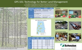
The global positioning system (GPS) and geographic information systems             8 Workshops: 1 Per 8 workshops : Tuscaloosa,     Programs in the northern See Chart
                                                                                        Region        Sumter, Conecuh, Mobile,      and southeast part of    Below
(GIS) are important tools for owners in managing their land and forests.                              Autauga, Cullman, Dallas, and the state were limited
The goal of the project, “GPS 101: Technology for Better Land                                         Clarke
Management”, was to educate participants on GPS and GIS and on how
                                                                                                               Other workshops: Blount,
these technologies can assist in land management. The project promoted                                         Henry, and Mobile
the use of geospatial tools and applications, and the integration of
geospatial concepts in land management. The project consisted of eight               Support Manual            Support manual developed       Need to enhance manual NA
introductory-level workshops that were held in various Alabama counties               Short, Tutorial          Short, tutorial videos         Continue to develop
                                                                                                                                                                     NA
(Fig. 1 and 2). The target audience for the project was land owners who are               Videos               developed for Google Earth     additional videos                        Figure 4
                                                                                   Figure 1                                                                                                                         Figure 5
interested in incorporating geospatial technologies into their management
strategies. The project outcomes and impacts were measured using tests                                                                                                                 Hands-On GPS Training
and surveys to determine what participants learned and whether it
                                                                                                                  2011 Workshop Locations
changed their land management behaviors (Fig. 3).
The workshops included presentations (Fig. 4 and 5), GPS exercises and GIS
software training on laptop computers. GPS exercises consisted of hands-
on training on the use of GPS hardware and on typical data collection tasks,
including waypoint collection and area calculation (Fig. 6 and 7). GIS
software training consisted of GPS data import and analysis, map creation
and editing, and data creation and editing (Fig. 8 and 9). As a result of post-
workshop evaluations and collaborator discussions, a workshop manual has                                                                                                               Figure 6
been developed. The manual includes workshop presentations, articles,                                                                                                                                               Figure 7

tutorials, and a CD containing geospatial software and additional articles.                                                                                                            Hands-On Computer Training
Pre and post-workshop tests showed an increase in attendee knowledge of
geospatial technologies. A survey showed that workshop attendees have
incorporated geospatial technologies into their land management practices.
Workshop evaluations indicate interest in further training.
                                                                                               Figure 2
Outcomes and Impacts
                                                                                                                       Overall       First GPS                               Self-
                                                                                                    Number of                                           Pre/Post Test =
The eight workshops conducted during 2011 resulted in 142 people being              Location                          Workshop      Workshop for                           Learning
                                                                                                    Attendees                                          Knowledge Change
                                                                                                                       Quality       Attendee                             Evaluation
educated on geospatial technologies. Of those, 128 had never attended a
                                                                                  Thomasville             25            94%             75%            74% to 92% = 18%       NA
geospatial technologies workshop. Attendees scored the workshop at a
                                                                                  Selma                   9              88%                33%        76% to 96% = 20%      NA        Figure 8
grade of 90%, based on post-workshop evaluations. Pre and post tests
                                                                                  Cullman                 25             90%                65%        63% to 92% = 29%      NA                                     Figure 9
showed an average 23% increase in knowledge of geospatial technologies.
                                                                                  Autaugaville            16             90%                80%        76% to 92% = 16%      NA
A survey conducted in early 2012 revealed that as a result of attending the
                                                                                  Mobile                  17             93%                NA         72% to 92% = 20%      NA
workshop, 12.5% of respondents purchased a GPS unit and 6.3% purchased
                                                                                  Evergreen               17             93%                76%        63% to 97% = 34%      NA
mapping software. Based on what they learned in the workshop, 68.8% of
                                                                                  Livingston              15             85%              100%                NA             88%
respondents utilized geospatial technologies at home or in their work and
all of those respondents replied that the information learned in the              Tuscaloosa              18             87%                68%               NA             92%

workshop made the technology easier to adopt.                                     TOTALs                  142            90%                71%               23%            90%
                                                                                  Figure 3

Mais conteúdo relacionado

Semelhante a Gps 101 c_dillard

Komarwebinarsposter nacaa2011
Komarwebinarsposter nacaa2011Komarwebinarsposter nacaa2011
Komarwebinarsposter nacaa2011nacaa
 
Land use land cover mapping for smart village using gis
Land use land cover mapping for smart village using gisLand use land cover mapping for smart village using gis
Land use land cover mapping for smart village using gisSumit Yeole
 
Curriculum Vitae - 26th July 2019
Curriculum Vitae - 26th July 2019Curriculum Vitae - 26th July 2019
Curriculum Vitae - 26th July 2019Mericha Masta
 
Final thesis presentation
Final thesis presentationFinal thesis presentation
Final thesis presentationPawan Singh
 
The Nile Basin Development Challenge: A component of the CGIAR Challenge Pro...
The Nile Basin Development Challenge: A component of  the CGIAR Challenge Pro...The Nile Basin Development Challenge: A component of  the CGIAR Challenge Pro...
The Nile Basin Development Challenge: A component of the CGIAR Challenge Pro...ILRI
 
The first 100_steps_to_geoss
The first 100_steps_to_geossThe first 100_steps_to_geoss
The first 100_steps_to_geossRobert Jerzy Lach
 
Official and crowdsourced geospatial data integration
Official and crowdsourced geospatial data integrationOfficial and crowdsourced geospatial data integration
Official and crowdsourced geospatial data integrationJimena Martínez
 
Graphical Resume
Graphical ResumeGraphical Resume
Graphical Resumefcfahl
 
A Quick Guide to Building a GIS for Your Public Safety Agency
A Quick Guide to Building a GIS for Your Public Safety AgencyA Quick Guide to Building a GIS for Your Public Safety Agency
A Quick Guide to Building a GIS for Your Public Safety AgencyEsri
 
Cadastre Information System - Esri IUC 2011, San Diego - CA
Cadastre Information System - Esri IUC 2011, San Diego - CACadastre Information System - Esri IUC 2011, San Diego - CA
Cadastre Information System - Esri IUC 2011, San Diego - CAFernando Gil
 
L N Dewangan_Resume
L  N  Dewangan_ResumeL  N  Dewangan_Resume
L N Dewangan_ResumeL N Dewangan
 

Semelhante a Gps 101 c_dillard (20)

Mrp Final
Mrp FinalMrp Final
Mrp Final
 
Komarwebinarsposter nacaa2011
Komarwebinarsposter nacaa2011Komarwebinarsposter nacaa2011
Komarwebinarsposter nacaa2011
 
Land use land cover mapping for smart village using gis
Land use land cover mapping for smart village using gisLand use land cover mapping for smart village using gis
Land use land cover mapping for smart village using gis
 
RESUME_VIDHYA_MOHANDAS
RESUME_VIDHYA_MOHANDASRESUME_VIDHYA_MOHANDAS
RESUME_VIDHYA_MOHANDAS
 
Ijetcas14 474
Ijetcas14 474Ijetcas14 474
Ijetcas14 474
 
Curriculum Vitae - 26th July 2019
Curriculum Vitae - 26th July 2019Curriculum Vitae - 26th July 2019
Curriculum Vitae - 26th July 2019
 
Final thesis presentation
Final thesis presentationFinal thesis presentation
Final thesis presentation
 
Deus GIS Portfolio
Deus GIS PortfolioDeus GIS Portfolio
Deus GIS Portfolio
 
Sutapa_resume
Sutapa_resumeSutapa_resume
Sutapa_resume
 
The Nile Basin Development Challenge: A component of the CGIAR Challenge Pro...
The Nile Basin Development Challenge: A component of  the CGIAR Challenge Pro...The Nile Basin Development Challenge: A component of  the CGIAR Challenge Pro...
The Nile Basin Development Challenge: A component of the CGIAR Challenge Pro...
 
FlyerAGIen
FlyerAGIenFlyerAGIen
FlyerAGIen
 
The first 100_steps_to_geoss
The first 100_steps_to_geossThe first 100_steps_to_geoss
The first 100_steps_to_geoss
 
Connected vehicle highway network applications
Connected vehicle highway network applicationsConnected vehicle highway network applications
Connected vehicle highway network applications
 
Discovering Honolulu Data
Discovering Honolulu DataDiscovering Honolulu Data
Discovering Honolulu Data
 
Official and crowdsourced geospatial data integration
Official and crowdsourced geospatial data integrationOfficial and crowdsourced geospatial data integration
Official and crowdsourced geospatial data integration
 
Graphical Resume
Graphical ResumeGraphical Resume
Graphical Resume
 
Resume_Basheer_2017
Resume_Basheer_2017Resume_Basheer_2017
Resume_Basheer_2017
 
A Quick Guide to Building a GIS for Your Public Safety Agency
A Quick Guide to Building a GIS for Your Public Safety AgencyA Quick Guide to Building a GIS for Your Public Safety Agency
A Quick Guide to Building a GIS for Your Public Safety Agency
 
Cadastre Information System - Esri IUC 2011, San Diego - CA
Cadastre Information System - Esri IUC 2011, San Diego - CACadastre Information System - Esri IUC 2011, San Diego - CA
Cadastre Information System - Esri IUC 2011, San Diego - CA
 
L N Dewangan_Resume
L  N  Dewangan_ResumeL  N  Dewangan_Resume
L N Dewangan_Resume
 

Mais de nacaa

A gsploration nacaa 2012 poster
A gsploration nacaa 2012 posterA gsploration nacaa 2012 poster
A gsploration nacaa 2012 posternacaa
 
Yutzy, nacaa2012, Poster
Yutzy, nacaa2012, PosterYutzy, nacaa2012, Poster
Yutzy, nacaa2012, Posternacaa
 
Greenhalgh noxious weed poster for nacaa 2012
Greenhalgh noxious weed poster for nacaa 2012Greenhalgh noxious weed poster for nacaa 2012
Greenhalgh noxious weed poster for nacaa 2012nacaa
 
Infante casella and carleo poster nj
Infante casella and carleo poster njInfante casella and carleo poster nj
Infante casella and carleo poster njnacaa
 
Nacaa annie's diverse audience poster
Nacaa annie's diverse audience posterNacaa annie's diverse audience poster
Nacaa annie's diverse audience posternacaa
 
Baker beef camp poster2
Baker beef camp poster2Baker beef camp poster2
Baker beef camp poster2nacaa
 
Byers2012 nacaa poster
Byers2012 nacaa posterByers2012 nacaa poster
Byers2012 nacaa posternacaa
 
Poster gary gao_grapewineanalysisworkshop_nacaa_2012
Poster gary gao_grapewineanalysisworkshop_nacaa_2012Poster gary gao_grapewineanalysisworkshop_nacaa_2012
Poster gary gao_grapewineanalysisworkshop_nacaa_2012nacaa
 
Md small flock research survey 2012 poster (1) draft (2)
Md small flock research survey 2012 poster (1) draft (2)Md small flock research survey 2012 poster (1) draft (2)
Md small flock research survey 2012 poster (1) draft (2)nacaa
 
Mg vphonetraining edcrrn
Mg vphonetraining edcrrnMg vphonetraining edcrrn
Mg vphonetraining edcrrnnacaa
 
Lentz es nonohwheat12
Lentz es nonohwheat12Lentz es nonohwheat12
Lentz es nonohwheat12nacaa
 
Haller hay feeding poster
Haller   hay feeding posterHaller   hay feeding poster
Haller hay feeding posternacaa
 
Shannon prec ag software nacaa poster
Shannon prec ag software nacaa posterShannon prec ag software nacaa poster
Shannon prec ag software nacaa posternacaa
 
Haller hay feeding poster
Haller   hay feeding posterHaller   hay feeding poster
Haller hay feeding posternacaa
 
2012 cotton beltwide curry poster2
2012 cotton beltwide curry poster22012 cotton beltwide curry poster2
2012 cotton beltwide curry poster2nacaa
 
Arnold reduce phos
Arnold reduce phosArnold reduce phos
Arnold reduce phosnacaa
 
Lantz poster2012
Lantz poster2012Lantz poster2012
Lantz poster2012nacaa
 
Hoorman nacaa2012
Hoorman nacaa2012Hoorman nacaa2012
Hoorman nacaa2012nacaa
 
Goodson poster
Goodson posterGoodson poster
Goodson posternacaa
 
Gourd onion 42x42
Gourd onion 42x42Gourd onion 42x42
Gourd onion 42x42nacaa
 

Mais de nacaa (20)

A gsploration nacaa 2012 poster
A gsploration nacaa 2012 posterA gsploration nacaa 2012 poster
A gsploration nacaa 2012 poster
 
Yutzy, nacaa2012, Poster
Yutzy, nacaa2012, PosterYutzy, nacaa2012, Poster
Yutzy, nacaa2012, Poster
 
Greenhalgh noxious weed poster for nacaa 2012
Greenhalgh noxious weed poster for nacaa 2012Greenhalgh noxious weed poster for nacaa 2012
Greenhalgh noxious weed poster for nacaa 2012
 
Infante casella and carleo poster nj
Infante casella and carleo poster njInfante casella and carleo poster nj
Infante casella and carleo poster nj
 
Nacaa annie's diverse audience poster
Nacaa annie's diverse audience posterNacaa annie's diverse audience poster
Nacaa annie's diverse audience poster
 
Baker beef camp poster2
Baker beef camp poster2Baker beef camp poster2
Baker beef camp poster2
 
Byers2012 nacaa poster
Byers2012 nacaa posterByers2012 nacaa poster
Byers2012 nacaa poster
 
Poster gary gao_grapewineanalysisworkshop_nacaa_2012
Poster gary gao_grapewineanalysisworkshop_nacaa_2012Poster gary gao_grapewineanalysisworkshop_nacaa_2012
Poster gary gao_grapewineanalysisworkshop_nacaa_2012
 
Md small flock research survey 2012 poster (1) draft (2)
Md small flock research survey 2012 poster (1) draft (2)Md small flock research survey 2012 poster (1) draft (2)
Md small flock research survey 2012 poster (1) draft (2)
 
Mg vphonetraining edcrrn
Mg vphonetraining edcrrnMg vphonetraining edcrrn
Mg vphonetraining edcrrn
 
Lentz es nonohwheat12
Lentz es nonohwheat12Lentz es nonohwheat12
Lentz es nonohwheat12
 
Haller hay feeding poster
Haller   hay feeding posterHaller   hay feeding poster
Haller hay feeding poster
 
Shannon prec ag software nacaa poster
Shannon prec ag software nacaa posterShannon prec ag software nacaa poster
Shannon prec ag software nacaa poster
 
Haller hay feeding poster
Haller   hay feeding posterHaller   hay feeding poster
Haller hay feeding poster
 
2012 cotton beltwide curry poster2
2012 cotton beltwide curry poster22012 cotton beltwide curry poster2
2012 cotton beltwide curry poster2
 
Arnold reduce phos
Arnold reduce phosArnold reduce phos
Arnold reduce phos
 
Lantz poster2012
Lantz poster2012Lantz poster2012
Lantz poster2012
 
Hoorman nacaa2012
Hoorman nacaa2012Hoorman nacaa2012
Hoorman nacaa2012
 
Goodson poster
Goodson posterGoodson poster
Goodson poster
 
Gourd onion 42x42
Gourd onion 42x42Gourd onion 42x42
Gourd onion 42x42
 

Último

Gardella_PRCampaignConclusion Pitch Letter
Gardella_PRCampaignConclusion Pitch LetterGardella_PRCampaignConclusion Pitch Letter
Gardella_PRCampaignConclusion Pitch LetterMateoGardella
 
Paris 2024 Olympic Geographies - an activity
Paris 2024 Olympic Geographies - an activityParis 2024 Olympic Geographies - an activity
Paris 2024 Olympic Geographies - an activityGeoBlogs
 
Nutritional Needs Presentation - HLTH 104
Nutritional Needs Presentation - HLTH 104Nutritional Needs Presentation - HLTH 104
Nutritional Needs Presentation - HLTH 104misteraugie
 
Presentation by Andreas Schleicher Tackling the School Absenteeism Crisis 30 ...
Presentation by Andreas Schleicher Tackling the School Absenteeism Crisis 30 ...Presentation by Andreas Schleicher Tackling the School Absenteeism Crisis 30 ...
Presentation by Andreas Schleicher Tackling the School Absenteeism Crisis 30 ...EduSkills OECD
 
Unit-IV- Pharma. Marketing Channels.pptx
Unit-IV- Pharma. Marketing Channels.pptxUnit-IV- Pharma. Marketing Channels.pptx
Unit-IV- Pharma. Marketing Channels.pptxVishalSingh1417
 
Introduction to Nonprofit Accounting: The Basics
Introduction to Nonprofit Accounting: The BasicsIntroduction to Nonprofit Accounting: The Basics
Introduction to Nonprofit Accounting: The BasicsTechSoup
 
fourth grading exam for kindergarten in writing
fourth grading exam for kindergarten in writingfourth grading exam for kindergarten in writing
fourth grading exam for kindergarten in writingTeacherCyreneCayanan
 
Holdier Curriculum Vitae (April 2024).pdf
Holdier Curriculum Vitae (April 2024).pdfHoldier Curriculum Vitae (April 2024).pdf
Holdier Curriculum Vitae (April 2024).pdfagholdier
 
Accessible design: Minimum effort, maximum impact
Accessible design: Minimum effort, maximum impactAccessible design: Minimum effort, maximum impact
Accessible design: Minimum effort, maximum impactdawncurless
 
Measures of Dispersion and Variability: Range, QD, AD and SD
Measures of Dispersion and Variability: Range, QD, AD and SDMeasures of Dispersion and Variability: Range, QD, AD and SD
Measures of Dispersion and Variability: Range, QD, AD and SDThiyagu K
 
Sports & Fitness Value Added Course FY..
Sports & Fitness Value Added Course FY..Sports & Fitness Value Added Course FY..
Sports & Fitness Value Added Course FY..Disha Kariya
 
Explore beautiful and ugly buildings. Mathematics helps us create beautiful d...
Explore beautiful and ugly buildings. Mathematics helps us create beautiful d...Explore beautiful and ugly buildings. Mathematics helps us create beautiful d...
Explore beautiful and ugly buildings. Mathematics helps us create beautiful d...christianmathematics
 
Gardella_Mateo_IntellectualProperty.pdf.
Gardella_Mateo_IntellectualProperty.pdf.Gardella_Mateo_IntellectualProperty.pdf.
Gardella_Mateo_IntellectualProperty.pdf.MateoGardella
 
SOCIAL AND HISTORICAL CONTEXT - LFTVD.pptx
SOCIAL AND HISTORICAL CONTEXT - LFTVD.pptxSOCIAL AND HISTORICAL CONTEXT - LFTVD.pptx
SOCIAL AND HISTORICAL CONTEXT - LFTVD.pptxiammrhaywood
 
Advanced Views - Calendar View in Odoo 17
Advanced Views - Calendar View in Odoo 17Advanced Views - Calendar View in Odoo 17
Advanced Views - Calendar View in Odoo 17Celine George
 
microwave assisted reaction. General introduction
microwave assisted reaction. General introductionmicrowave assisted reaction. General introduction
microwave assisted reaction. General introductionMaksud Ahmed
 
This PowerPoint helps students to consider the concept of infinity.
This PowerPoint helps students to consider the concept of infinity.This PowerPoint helps students to consider the concept of infinity.
This PowerPoint helps students to consider the concept of infinity.christianmathematics
 

Último (20)

Gardella_PRCampaignConclusion Pitch Letter
Gardella_PRCampaignConclusion Pitch LetterGardella_PRCampaignConclusion Pitch Letter
Gardella_PRCampaignConclusion Pitch Letter
 
Paris 2024 Olympic Geographies - an activity
Paris 2024 Olympic Geographies - an activityParis 2024 Olympic Geographies - an activity
Paris 2024 Olympic Geographies - an activity
 
Mattingly "AI & Prompt Design: Structured Data, Assistants, & RAG"
Mattingly "AI & Prompt Design: Structured Data, Assistants, & RAG"Mattingly "AI & Prompt Design: Structured Data, Assistants, & RAG"
Mattingly "AI & Prompt Design: Structured Data, Assistants, & RAG"
 
Advance Mobile Application Development class 07
Advance Mobile Application Development class 07Advance Mobile Application Development class 07
Advance Mobile Application Development class 07
 
Nutritional Needs Presentation - HLTH 104
Nutritional Needs Presentation - HLTH 104Nutritional Needs Presentation - HLTH 104
Nutritional Needs Presentation - HLTH 104
 
Presentation by Andreas Schleicher Tackling the School Absenteeism Crisis 30 ...
Presentation by Andreas Schleicher Tackling the School Absenteeism Crisis 30 ...Presentation by Andreas Schleicher Tackling the School Absenteeism Crisis 30 ...
Presentation by Andreas Schleicher Tackling the School Absenteeism Crisis 30 ...
 
Unit-IV- Pharma. Marketing Channels.pptx
Unit-IV- Pharma. Marketing Channels.pptxUnit-IV- Pharma. Marketing Channels.pptx
Unit-IV- Pharma. Marketing Channels.pptx
 
Introduction to Nonprofit Accounting: The Basics
Introduction to Nonprofit Accounting: The BasicsIntroduction to Nonprofit Accounting: The Basics
Introduction to Nonprofit Accounting: The Basics
 
Mattingly "AI & Prompt Design: The Basics of Prompt Design"
Mattingly "AI & Prompt Design: The Basics of Prompt Design"Mattingly "AI & Prompt Design: The Basics of Prompt Design"
Mattingly "AI & Prompt Design: The Basics of Prompt Design"
 
fourth grading exam for kindergarten in writing
fourth grading exam for kindergarten in writingfourth grading exam for kindergarten in writing
fourth grading exam for kindergarten in writing
 
Holdier Curriculum Vitae (April 2024).pdf
Holdier Curriculum Vitae (April 2024).pdfHoldier Curriculum Vitae (April 2024).pdf
Holdier Curriculum Vitae (April 2024).pdf
 
Accessible design: Minimum effort, maximum impact
Accessible design: Minimum effort, maximum impactAccessible design: Minimum effort, maximum impact
Accessible design: Minimum effort, maximum impact
 
Measures of Dispersion and Variability: Range, QD, AD and SD
Measures of Dispersion and Variability: Range, QD, AD and SDMeasures of Dispersion and Variability: Range, QD, AD and SD
Measures of Dispersion and Variability: Range, QD, AD and SD
 
Sports & Fitness Value Added Course FY..
Sports & Fitness Value Added Course FY..Sports & Fitness Value Added Course FY..
Sports & Fitness Value Added Course FY..
 
Explore beautiful and ugly buildings. Mathematics helps us create beautiful d...
Explore beautiful and ugly buildings. Mathematics helps us create beautiful d...Explore beautiful and ugly buildings. Mathematics helps us create beautiful d...
Explore beautiful and ugly buildings. Mathematics helps us create beautiful d...
 
Gardella_Mateo_IntellectualProperty.pdf.
Gardella_Mateo_IntellectualProperty.pdf.Gardella_Mateo_IntellectualProperty.pdf.
Gardella_Mateo_IntellectualProperty.pdf.
 
SOCIAL AND HISTORICAL CONTEXT - LFTVD.pptx
SOCIAL AND HISTORICAL CONTEXT - LFTVD.pptxSOCIAL AND HISTORICAL CONTEXT - LFTVD.pptx
SOCIAL AND HISTORICAL CONTEXT - LFTVD.pptx
 
Advanced Views - Calendar View in Odoo 17
Advanced Views - Calendar View in Odoo 17Advanced Views - Calendar View in Odoo 17
Advanced Views - Calendar View in Odoo 17
 
microwave assisted reaction. General introduction
microwave assisted reaction. General introductionmicrowave assisted reaction. General introduction
microwave assisted reaction. General introduction
 
This PowerPoint helps students to consider the concept of infinity.
This PowerPoint helps students to consider the concept of infinity.This PowerPoint helps students to consider the concept of infinity.
This PowerPoint helps students to consider the concept of infinity.
 

Gps 101 c_dillard

  • 1. GPS 101: Technology for Better Land Management Chris Dillard; dillach@aces.edu; Alabama Cooperative Extension System Beau Brodbeck; brodbam@aces.edu; Alabama Cooperative Extension System Jack Rowe; wjr0001@aces.edu; Alabama Cooperative Extension System Abstract Deficiency & Program Presentations Expected Outputs Accomplished Outputs Explanation Outcomes The global positioning system (GPS) and geographic information systems 8 Workshops: 1 Per 8 workshops : Tuscaloosa, Programs in the northern See Chart Region Sumter, Conecuh, Mobile, and southeast part of Below (GIS) are important tools for owners in managing their land and forests. Autauga, Cullman, Dallas, and the state were limited The goal of the project, “GPS 101: Technology for Better Land Clarke Management”, was to educate participants on GPS and GIS and on how Other workshops: Blount, these technologies can assist in land management. The project promoted Henry, and Mobile the use of geospatial tools and applications, and the integration of geospatial concepts in land management. The project consisted of eight Support Manual Support manual developed Need to enhance manual NA introductory-level workshops that were held in various Alabama counties Short, Tutorial Short, tutorial videos Continue to develop NA (Fig. 1 and 2). The target audience for the project was land owners who are Videos developed for Google Earth additional videos Figure 4 Figure 1 Figure 5 interested in incorporating geospatial technologies into their management strategies. The project outcomes and impacts were measured using tests Hands-On GPS Training and surveys to determine what participants learned and whether it 2011 Workshop Locations changed their land management behaviors (Fig. 3). The workshops included presentations (Fig. 4 and 5), GPS exercises and GIS software training on laptop computers. GPS exercises consisted of hands- on training on the use of GPS hardware and on typical data collection tasks, including waypoint collection and area calculation (Fig. 6 and 7). GIS software training consisted of GPS data import and analysis, map creation and editing, and data creation and editing (Fig. 8 and 9). As a result of post- workshop evaluations and collaborator discussions, a workshop manual has Figure 6 been developed. The manual includes workshop presentations, articles, Figure 7 tutorials, and a CD containing geospatial software and additional articles. Hands-On Computer Training Pre and post-workshop tests showed an increase in attendee knowledge of geospatial technologies. A survey showed that workshop attendees have incorporated geospatial technologies into their land management practices. Workshop evaluations indicate interest in further training. Figure 2 Outcomes and Impacts Overall First GPS Self- Number of Pre/Post Test = The eight workshops conducted during 2011 resulted in 142 people being Location Workshop Workshop for Learning Attendees Knowledge Change Quality Attendee Evaluation educated on geospatial technologies. Of those, 128 had never attended a Thomasville 25 94% 75% 74% to 92% = 18% NA geospatial technologies workshop. Attendees scored the workshop at a Selma 9 88% 33% 76% to 96% = 20% NA Figure 8 grade of 90%, based on post-workshop evaluations. Pre and post tests Cullman 25 90% 65% 63% to 92% = 29% NA Figure 9 showed an average 23% increase in knowledge of geospatial technologies. Autaugaville 16 90% 80% 76% to 92% = 16% NA A survey conducted in early 2012 revealed that as a result of attending the Mobile 17 93% NA 72% to 92% = 20% NA workshop, 12.5% of respondents purchased a GPS unit and 6.3% purchased Evergreen 17 93% 76% 63% to 97% = 34% NA mapping software. Based on what they learned in the workshop, 68.8% of Livingston 15 85% 100% NA 88% respondents utilized geospatial technologies at home or in their work and all of those respondents replied that the information learned in the Tuscaloosa 18 87% 68% NA 92% workshop made the technology easier to adopt. TOTALs 142 90% 71% 23% 90% Figure 3