
Recomendados
Recomendados
Mais conteúdo relacionado
Destaque
Destaque (20)
Semelhante a Global maritime awareness ov 1 (expanded) -10 march 2013
Semelhante a Global maritime awareness ov 1 (expanded) -10 march 2013 (20)
Último
Último (20)
Global maritime awareness ov 1 (expanded) -10 march 2013
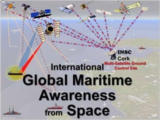
- 1. Multi-Satellite Ground Control SiteInternational Global Maritime Awareness from Space INSC Cork
- 2. Collaboration in Space for International Global Maritime Awareness C-SIGMA C ∑
- 3. International Collaboration is Key 2. COMSAT TRANS 1. S-AIS 4. EO 3. SAR Multi-Satellite Ground Site INSC Cork
- 4. AIS Space-based and Terrestrial AIS Rcv Only INSC Cork
- 5. Most ComSats have this capability ComSat LRIT, VMS, etc. INSC Cork
- 6. Day or Night, Clear or Cloudy Synthetic Aperture Radar (SARSAT) INSC Cork
- 8. INSC
- 9. Existing Potential* - Not to Scale - *some may exit Potential GMA Satellite Ground Terminal Locations
- 10. Presidential Policy Directive/PPD – 4 National Space Policy Implementation Action #1 Global Maritime Domain Awareness “ … develop an unclassified, internationally available program to foster international collaboration using civil and commercial space systems to enhance global maritime domain awareness… “
- 11. Presidential Policy Directive/PPD – 4 National Space Policy Implementation Action #1 Global Maritime Awareness “ … develop an unclassified, internationally available program to foster international collaboration using civil and commercial space systems to enhance global maritime domain awareness… “
- 12. Civil & Commercial Optical Satellites in Orbit Last updated early in 2007
- 13. Civil & Commercial Radar Satellites Last updated early in 2007 US has None
- 14. Legend Hi Res Opitcal Med Res Optical SAR SIGINT AIS Commercial Electro-optical Quickbird · WorldView-1 · WorldView-2 · Ikonos · GeoEye-1 · GeoEye-2 · SPOT · EO1-ALI · ASTER · LANDSAT · ALOS Synthetic Aperture Radar RADARSAT-1 · RADARSAT-2 · PALSAR International Electro-Optical Disaster Monitoring Constellation Brazil IMINT SCD-1 · SCD-2 · CBERS-1 · CBERS-2 · SSR China IMINT JSSW · FSW-0 · FSW-1 · FSW-2 · FSW-3 · JianBing · CBERS-2 (joint Brazil) · Yaogan SIGINT JSSW-3 · SJ-2 · DQ-1 COMM Feng Huo-1 · ShenTong-1 World Reconnaissance Satellites Excluding Russia and the United States France IMINT Hélios 1B · Helios 2A SIGINT Cerise · Clementine
- 15. Germany Synthetic Aperture Radar SAR Lupe Synthetic Aperture Radar TerraSAR-X · TanDEM-X India IMINT Cartosat-1 · Cartosat-2 · Cartosat-2A Synthetic Aperture Radar RISAT-2 Israel IMINT Ofeq -> Ofeq 5 · Ofeq 7 · Ofeq 9 SIGINT AMOS 1 · AMOS 2 · AMOS 3 · AMOS 4 Synthetic Aperture Radar Eros · TecSAR Italy Synthetic Aperture Radar COSMOS Sky-Med Japan IMINT IGS 1A/B · IGS 2A/B · IGS 3A · IGS 4A/B · IGS 5A South Korea IMINT Arirang-1 · Arirang-2 · Arirang-3 · Arirang-4 · Arirang-5 · Arirang-6 · Arirang-7 Retrieved from "http://en.wikipedia.org/wiki/China%E2%80%93Brazil_Earth_Resources_Satellite_program" World Reconnaissance Satellites Continued
- 16. 3/1/1984 Landsat 5 US 3/1/1984 ? 30 1/22/1990 SPOT-2 France 1/22/1990 10 20 4/21/1995 ERS-2 ESA 4/21/1995 30 ? 11/4/1995 RadarSat 1 Canada 11/4/1995 8.5 NA 12/28/1995 IRS 1C India 12/28/1995 6 23 9/29/1997 IRS 1D India 9/29/1997 6 23 3/24/1998 SPOT-4 France 3/24/1998 10 20 4/15/1999 Landsat 7 US 4/15/1999 15 30 9/24/1999 IKONOS-2 US 9/24/1999 1 4 12/15/1999 TERRA (ASTER) Japan/US 12/15/1999 3 15, 30, 90 12/20/1999 ARIRANG-1 (KOMPSAT-1) Korea 12/20/1999 6.6 ? 11/21/2000 EO-1 US 11/21/2000 10 30 12/5/2000 EROS A1 Israel 12/5/2000 1.8 10/18/2001 QuickBird-2 US 10/18/2001 0.6 2.5 10/22/2001 Technology ExperimentSatellite (TES) India 22-Oct-01 1 ? 10/22/2001 Proba ESA 10/22/2001 8 18, 36 3/1/2002 ENVISAT ESA 3/1/2002 30 NA 5/4/2002 SPOT-5 France 5/4/2002 2.5 10 11/28/2002 DMC AlSat-1 (SSTL) Algeria 11/28/2002 ? 32 6/26/2003 OrbView 3 US 6/26/2003 1 4 9/27/2003 DMC NigeriaSat-1 (SSTL) Nigeria 9/27/2003 ? 32 9/27/2003 DMC BilSat (SSTL) Turkey 9/27/2003 12 26 10/17/2003 IRS ResourceSat-1 India 10/17/2003 6 6, 23, 56 10/21/2003 CBERS-2 China/Brazil 10/21/2003 20 20 4/20/2004 FormoSat (RocSat2) Taiwan 4/20/2004 2 8 12/1/2004 ThaiPhat (SSTL) Thailand 12/1/2004 ? 36 5/4/2005 IRS Cartosat 1 India 5/4/2005 2.5 8/26/2005 MONITOR-E -1 Russia 8/26/2005 8 20 10/27/2005 Beijing-1 (SSTL) China 10/27/2005 4 32 1/24/2006 ALOS Japan 1/24/2006 2.5 10 Earth Observation Satellites with Potential Maritime Surveillance Capabilities
- 17. 4/25/2006 EROS B1 Israel 4/25/2006 0.7 6/15/2006 ResursDK-1 (01-N5) Russia 6/15/2006 1 3 28-Jul-06 Arirang-2 (KOMPSAT-2) Korea 28-Jul-06 1 11/1/2006 VinSat-1 (SSTL) Vietnam 11/1/2006 4 32 12/12/2006 Sumbandilasat South Africa 12/12/2006 ? 6.5 12/19/2006 SAR-Lupe-1 Germany 12/19/2006 ? NA 1/10/2007 IRS Cartosat 2 India 1/10/2007 1 6/8/2007 COSMO-Skymed-1 Italy 6/8/2007 1 NA 6/15/2007 TerraSAR X Germany 6/15/2007 1 NA 6/15/2007 CBERS-2B China/Brazil 6/15/2007 20 20 6/30/2007 THOES Thailand 6/30/2007 2 15 7/1/2007 HJ-1-A China 7/1/2007 ? 30, 100H 7/1/2007 HJ-1-B China 7/1/2007 ? 30,150,300 7/1/2007 WorldView -1 US 7/1/2007 0.5 7/2/2007 SAR-Lupe-2 Germany 7/2/2007 ? NA 11/1/2007 SAR-Lupe-3 Germany 11/1/2007 ? NA 12/9/2007 COSMO-Skymed-2 Italy 12/9/2007 1 NA 12/14/2007 RadarSat 2 Canada 12/14/2007 3 NA 1/21/2008 TecSAR Israel 1 NA China 3/1/2008 ? 5, 20 27-Mar-08 SAR-Lupe-4 Germany 3/27/2008 ? 4/16/2008 X-Sat Singapore 4/16/2008 ? 10 4/28/2008 Cartosat 2A (IRS P?) India 4/28/2008 ? ? 4/28/2008 IMS 1 (IRS P?) India 4/28/2008 ? ? 5/1/2008 CBERS-3 China/Brazil 5/1/2008 5 20 7/1/2008 WorldView -2 US 7/1/2008 0.5 1.8 7/22/2008 SAR-Lupe-5 Germany 7/22/2008 ? NA 8/1/2008 Venus Israel/France 8/1/2008 ? 5.3 8/15/2008 TerraSAR L Germany 8/15/2008 1 Earth Observation Satellites with Potential Maritime Surveillance Capabilities (continued)
- 18. 8/29/2008 RapidEye-A Germany 8/29/2008 5 6.5 8/29/2008 RapidEye-B Germany 8/29/2008 5 6.5 8/29/2008 RapidEye-C Germany 8/29/2008 5 6.5 8/29/2008 RapidEye-D Germany 8/29/2008 5 6.5 8/29/2008 RapidEye-E Germany 8/29/2008 5 6.5 9/6/2008 GeoEye-1 US 9/6/2008 0.41 1.64 10/25/2008 COSMO-Skymed-3 Italy 10/25/2008 1 ? 4/20/2009 RISAT India 4/20/2009 3 NA 7/14/2009 RazakSat* Malyasia 7/14/2009 2.5 5 12/1/2009 Alsat-2B Algeria 12/1/2009 2.5 10 6/21/2010 TanDem-X Germany 6/21/2010 1 NA 7/1/2010 Spain Sat Spain 7/1/2010 2.5 ? 7/11/2010 Alsat-2A Algeria 7/11/2010 2.5 10 7/11/2010 IRS Resource Sat-2 India 7/11/2010 6 6, 23, 56 7/12/2010 Cartosat-2B India 12-Jul-10 0.9 ? 8/24/2010 TianHui 1 China 8/24/2010 5 ? 11/5/2010 COSMO-Skymed-4 Italy 11/5/2010 1 NA 2/16/2011 RASAT Turkey 2/16/2011 ? ? 2/16/2011 Sich 2M Ukrainian 2/16/2011 ? ? 3/1/2011 Pleiades-1 France 3/1/2011 0.7 2.8 7/1/2011 Pleiades-2 France 7/1/2011 0.7 2.8 12/31/2012 LDCM US 12/31/2012 10 30 10/1/2014 CBERS-4 China/Brazil 10/1/2014 5 20 12/?/2010 EROS C Israel 12/?/2010 0.7 2.5 30/72/2009 DMC UK (SSTL) KU 30/72/90 ? 32 50/72/01 ? TopSat (SSTL) KU 50/72/01 2.5 5 6/30/2013? ALOS-2 Japan 6/30/2013? ? NA 6/6/2011? Svea Sweden 1.5 3 Earth Observation Satellites with Potential Maritime Surveillance Capabilities (continued)
Notas do Editor
- There are many different earth observation satellites in orbit today and more are planned. Combining the capabilities of four unclassified satellites constellations would go a long way toward the development of an unclassified global maritime awareness system.The next five slides will describe the unique contributions of each satellite type, as well as their synergistic potentially relationship.The next several slides list the various earth observation satellites (SAR & Optical) that either are on orbit or are planned.We plan to generate a similar list of satellites equipped with AIS.What is needed is a global coordination center. The Irish National Space Centre is ideally situation to assume that role
- The four satellite types are, from the left, Communications satellites which link to terrestrial location and short message reporting transponders.Space-based AIS receivers which collect the AIS collision avoidance beacons from SOLAS class ships, world-wide.Synthetic Aperture Radar (SAR) Satellites which heretofore collected primarily over land.Electro Optic/Infrared (EO/IR) imaging (photography) satellites.Ground sites capable of tasking and receiving data from multiple satellite types would greatly reduce the time latency of this system and make it much more tactically useful.
- Space-based AIS is now a reality, with both private companies and governments routinely collecting and processing the data for a wide variety of reasons. The private companies (the first two being exactEarth and ORBCOMM) are looking to sell the information to anyone with a legitimate need.
- Many ships communicate with various elements ashore, official and otherwise, routinely reporting their position.Examples include Long Range Identification and Tracking (LRIT) for all SOLAS class vessels (>300 tons and engaged in commerce) and Vessel Monitoring System (VMS) for fishing fleets, and other status reports required by many maritime companies.
- There are now about 10 highly capable civil and commercial Synthetic Aperture Radar Satellites in orbit, with over a dozen more planned. They can provide day/night, cloudy and clear coverage of the world’s oceans. (3 Modes, Strip, Sweep and Spotlight. Uplink and downlinking of commands and data in as timely amanner as possible is a crucual capability needed for maritime operations, thus INSC is ideal for the North Atlantic and E\Western Med.
- Several countries and companies in differing parts of the world are operating highly capable electro-optical imaging satellites. Many have multi-spectral and hyper-spectral capabilities. They can provide highly detailed images of both the ships themselves as well as their supporting infrastructure.Medium Resolution imaging satellites also have some utility here as at least “Blob” detectors.
- Latency of data gathered is a critical factor in tactical operations of all types, including those in the maritime domain.The time to task and then collect and process the data gathered from satellites is highly dependent on the location and number of ground stations which can task and then receive the data. This slide shows a proposed network of sites stretching across the Atlantic.
- Title is self explanatory. This is just an example and is not meant as anything other than an illustration.
- The Implementation Plan has been written but, unfortunately, no funding has been identified.
- From William E. Stoney’s work
- From William E. Stoney’s work
- IEEE graphic
- IEEE graphic
- Research done as a web search in late 2010 by Guy Thomas.Additions /deletions /corrections welcomed
- Research done as a web search in late 2010 by Guy Thomas.Additions /deletions /corrections welcomed
- Research done as a web search in late 2010 by Guy Thomas.Additions /deletions /corrections welcomed