Floodplain Management Adapting To A Changing Climate Freitag De Pue Asfpm 2010
•
1 gostou•536 visualizações


Recomendados
Recomendados
Mais conteúdo relacionado
Semelhante a Floodplain Management Adapting To A Changing Climate Freitag De Pue Asfpm 2010
Semelhante a Floodplain Management Adapting To A Changing Climate Freitag De Pue Asfpm 2010 (16)
Floodplain Management Adapting To A Changing Climate Freitag De Pue Asfpm 2010
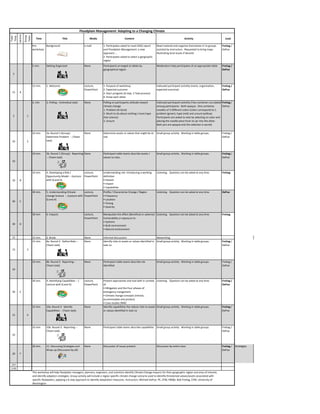
- 1. Floodplain Management: Adapting to a Changing Climate Lecture Group Tasks Total Time Time Title Media Content Activity Lead Pre- Background e-mail 1. Participates asked to read USGS report Read material and organize themselves in to groups Freitag / workshop and Floodplain Management: a new assisted by instructors. Requested to bring maps DePue approach…. illustrating local issues if desired. 2. Participates asked to select a geographic region 5 min. Getting Organized None Participants arranged at tables by Moderators help participates sit at appropriate table Freitag / geographical region DePue 5 15 min. 1. Welcome Lecture, 1. Purpose of workshop Indivudal participant activilty (name, organization, Freitag / PowerPoint 2. Expected outcome expected outcome) DePue 15 A 3. Day’s program (6 step, 3 Task process) 4. Know each other. 2. min 2. Polling – (individual task) None Polling on participants attitude toward Indivudal participant activilty (Two container curculated Freitag / climate change among participants. Both opaque. One containes DePue 1. Problem (Al Gore) noodles of 3 different colors Colors correspond to 1. 2. Much to do about nothing ( more hype problem (green), hype (red) and unsure (yellow). 2 1 that science) Participants are asked to vote by selecting on color and 3. Unsure placing the noodle piece from on jar into the other. Both jars are opaque and the selection is secret) 10 min. 3a. Round 1 (Group): None Determine assets or values that might be at Small group activity. Working in table groups. Freitag / Determine Problem -- (Team risk. DePue 10 2 task) 10 min. 3b. Round 1 (Group): Reporting None Participant table teams describe assets / Small group activity. Working in table groups. Freitag / -- (Team task) values to class. DePue 10 10 min. 4. Developing a Risk / Lecture, Understanding risk. Introducing a working Listening. Question can be asked at any time. Freitag Opportunity Model -- (Lecture PowerPoint definition 10 B with Q and A) • Hazard • Impact • Capabilities 40 min. 5. Understanding Climate Lecture, Profile / Characterize Change / Region Listening. Question can be asked at any time. DePue change Science -- (Lecture with PowerPoint • Frequency Q and A) • Location 40 C • Timing • Severity 30 min 6. Impacts Lecture, Manipulate the effect (Beneficial or adverse) Listening. Question can be asked at any time. Freitag PowerPoint Vulnerability or exposure to • Systems 30 D • Built environment • Natural environment 15 15 min. 6. Break None Informal discussions Networking 15 min. 8a. Round 2: Define Risks -- None Identify risks to assets or values identified in Small group activity. Working in table groups. Freitag / (Team task) task 1a DePue 15 3 10 min. 8b. Round 2: Reporting -- None Participant table teams describe risk Small group activity. Working in table groups. Freitag / (Team task) identified DePue 10 30 min. 9. Identifying Capabilities -- ( Lecture, Present approaches and tool with in context Listening. Question can be asked at any time. Freitag / Lecture with Q and A) PowerPoint of DePue • Mitigation and the Four phases of 30 E emergency mangement • Climate change concepts (retreat, accommodate and protect) • Case studies (NW) 15 min. 10a. Round 3: Identify None Identify capabiliites the reduce risks to assets Small group activity. Working in table groups. Freitag / Capabilities -- (Team task) or values identified in task 1a DePue 15 4 10 min. 10b. Round 3: Reporting -- None Participant table teams describe capabilities Small group activity. Working in table groups. Freitag / (Team task) DePue 10 20 min. 11. Discussing Strategies and None Discussion of issues present Discussion by entire class Freitag / Strategies Wrap-up (Discussion by all) DePue 20 F 237 3.95 This workshop will help floodplain managers, planners, engineers, and scientists identify Climate Change impacts for their geographic region and area of interest; and identify adaption strategies. Group activity will include a region specific climate change scenario used to identify threatened values/assets associated with specific floodplains, applying a 6 step approach to identify adaptation measures. Instructors: Michael DePue, PE, CFM, PBS&J; Bob Freitag, CFM, University of Washington
- 2. 5/20/2010 Floodplain Management: Adapting to a Changing Climate Bob Freitag CFM (University of Washington Michael DePue PE, CFM (PBS&J) Originally published on Tuesday, December 23, 2008 E-mail cartoon Printer-friendly 1
- 3. 5/20/2010 Adapting to a Changing Climate 1. Welcome 2. Polling – (individual task) 3. Round 1 (Group): Determine Problem and Reporting -- (Team task) 4. Developing a Risk / Opportunity Model -- (Lecture with Q and A) 5. Understanding Climate change Science -- (Lecture with Q and A) 6. Break 7. Identifying Climate Change Impacts -- ( Lecture with Q and A) 8. Round 2: Define Risks and Reporting -- (Team task) 9. Identifying Capabilities -- ( Lecture with Q and A) 10. Round 3: Identify Capabilities and Reporting -- (Team task) 11. Discussing Strategies and Wrap-up (Discussion by all) Floods Are Not the Problem Six Questions to ask when choosing a plan to control the effects of flooding: 1. What values or assets do you want to protect or enhance? 2. What are the apparent risks of opportunities for enhancement? 3. What is the range of risk-reduction or opportunity- enhancement strategies available? 4. How well does each strategy reduce the risk or enhance the resource? 5. What other risks or benefits does each strategy introduce? 6. Are the costs imposed by each strategy too high? 2
- 4. 5/20/2010 A New Vocabulary • Flood: Neither positive or negative; it is simply water spilling over its banks. A change in condition that could be a hazard or lead to an opportunity • Hazard: Often seen as something with a potentially adverse effect. “Change” may be a better word. • Change: A change in condition could be a hazards or lead to an opportunity • Opportunities: can be viewed as being similar but opposite of risk; the benefits • Risk: a function of “Change” in condition, Impacts and Capabilities. Risk and Opportunities are different sides of the same coin. • Disaster: a realized risk • Benefit: a realized opportunity. • Mitigation and adaptation ( with flooding being a secondary hazard) • Adaptation: Retreat, accommodate, protect Resiliency – “the ability to tolerate change” 3
- 5. 5/20/2010 Ecological Resilience vs. Engineering Resilience • Ecological Resilience is a Better Framework Engineering Resilience Ecological Resilience Seeks stability Accepts inevitability of change Resists disturbance Absorbs and recovers from disturbance One equilibrium point Multiple, non-stable equilibria Single acceptable outcome Multiple acceptable outcomes Predictability Unpredictability Fail-safe Safe-fail Narrow tolerances Wide tolerances Rigid boundaries and edges Flexible boundaries and edges Efficiency of function Persistence of function Redundancy of structure Redundancy of function 4
- 6. 5/20/2010 A Resilient City Case Study: Snoqualmie, Washington • Case Study: Snoqualmie, Washington – 698 of 700 housing units in floodplain – 13 disaster flood related declarations between 1965 and 2001 – Water is clean, slow-moving and comes with warning – Flooding benefits downstream communities. – Most severely floodprone homes have been elevated. (several hundred since 1986) – City amenities defined by river and river location • Climate change is increasing flood frequency. • Snoqualmie will always flood. • Snoqualmie is becoming resilient to flood damage. 5
- 7. 5/20/2010 Northwest Northeast Midwest Great Plains Southwest Southeast USGS Teams 1. Welcome • Northeast 2. Polling – (individual task) • Southeast 3. Round 1 (Group): Determine Problem and Reporting -- (Team task) • Midwest 4. Developing a Risk / Opportunity Model -- (Lecture with Q and A) • Great Plains 5. Understanding Climate change Science -- (Lecture with Q and A) • Southwest 6. Break 7. Identifying Climate Change Impacts • Northwest -- ( Lecture with Q and A) 8. Round 2: Define Risks and • Alaska Reporting -- (Team task) 9. Identifying Capabilities -- ( Lecture • Islands with Q and A) 10. Round 3: Identify Capabilities and • Coasts Reporting -- (Team task) 11. Discussing Strategies and Wrap-up (Discussion by all) 6
- 8. 5/20/2010 Floodplain Management: Adapting to a Changing Climate Round 1 (Group): Determine Problem and Reporting Adapting to a Changing Climate 1. Welcome 2. Polling – (individual task) 3. Round 1 (Group): Determine Problem and Reporting -- (Team task) 4. Developing a Risk / Opportunity Model -- (Lecture with Q and A) 5. Understanding Climate change Science -- (Lecture with Q and A) 6. Break 7. Identifying Climate Change Impacts -- ( Lecture with Q and A) 8. Round 2: Define Risks and Reporting -- (Team task) 9. Identifying Capabilities -- ( Lecture with Q and A) 10. Round 3: Identify Capabilities and Reporting -- (Team task) 11. Discussing Strategies and Wrap-up (Discussion by all) 1
- 9. 5/20/2010 Six Step Process 1. What values or assets do you want to protect or enhance? 2. What are the apparent risks or opportunities for enhancement? 3. What is the range of risk-reduction or opportunity- enhancement strategies available? 4. How well does each strategy reduce the risk or enhance the resource? 5. What other risks or benefits does each strategy introduce? 6. Are the costs imposed by each strategy too high? 2
- 10. 5/20/2010 Adapting to a Changing Climate: Developing a Risk / Opportunity Model Six Step Process 1. What values or assets do you want to protect or enhance? 2. What are the apparent risks or opportunities for enhancement? 3. What is the range of risk-reduction or opportunity- enhancement strategies available? 4. How well does each strategy reduce the risk or enhance the resource? 5. What other risks or benefits does each strategy introduce? 6. Are the costs imposed by each strategy too high? 1
- 11. 5/20/2010 Risks and Opportunities Resiliency: The ultimate goal: being able to tolerate (benefit from) change. Risks and Opportunities (Result of change, effect, and capability) Focus on change Manipulate the effect Capabilities Primary and secondary Beneficial or adverse Strategies made up of Hazard of disturbance Vulnerability or exposure approaches and tools Location Systems: Money Frequency Built environment Power Severity Natural environment Timing Timing Disaster: Realized Risk Benefit Realized Opportunity Risks and Opportunities Focus on Manipulate the effect Primary and secondary hazard Beneficial or adverse or disturbance or exposure • Location • Frequency Systems: • Severity • Built environment • Timing • Natural environment • Societal, political, and organizational Strategies made up of approaches and tools • Money • Power • Timing 2
- 12. 5/20/2010 Geographic Information Systems (GIS) Layers Exposed inventory (e.g. Points Floodprone parcels with without road accesses) Infrastructures - inventory (e.g access roads) Polygons Parcels – inventory Change 2 (floodway can be raster or vector) Lines Change 1 (floodplain can be raster or vector) Real World (floodplain) Risk /Opportunity = f ( exposed Inventory / change ) RISK / (OPPORTUNITY) ASSESSMENT ACCEPTABLE RISK (ACHIEVEABLE OPPORTUNITY) •HAZARD/CHANGE RISK/OPP. •Impacts UNACCEPTABLE RISK/OPP. •Capabilities RISK REDUCTION / OPPORTUNITY ENHANSEMENT POLICY OPTIONS Natural Environment •PREVENTION/MITIGATION - Climate - Biology •PREPAREDNESS - Geology •EMERGENCY RESPONSE Built Environment •RECOVERY and - Structures - Infrastructure RECONSTRUCTION Systems 3
- 13. 5/20/2010 Natural Processes Must Drive Solutions • Case Study: New York, New York – The Catskill/Delaware watershed provides 90% of the drinking water for New York City. The 1600 square mile watershed allows excellent filtration with some chlorination to kill microorganisms. – Development in the Catskills threatened the ability of the watershed to filter the water naturally and the EPA began to demand that New York install a new filtration system costing billions. • The Six Questions revisited: 1. What values or assets do you want to protect or enhance? 2. What are the apparent risks of opportunities for enhancement? 3. What is the range of risk-reduction or opportunity-enhancement strategies available? 4. How well does each strategy reduce the risk or enhance the resource? 5. What other risks or benefits does each strategy introduce? 6. Are the costs imposed by each strategy too high? 4
- 14. 5/20/2010 Adapting to a Changing Climate: Profiling the Change 1
- 15. 5/20/2010 Outline • Introduction • Overview of Broad Trends • Impact of Climate Change in the United States by region – Frequency – Location – Timing – Severity What is “Climate Change”? • “Climate Change” is the term for the change in the statistical distribution of weather over periods of time that range from decades to millions of years. • In recent decades general climate change has been trending towards a gradual warming of the earth’s atmosphere and oceans. This upward temperature trend is usually called “Global Warming” 2
- 16. 5/20/2010 Global Warming Source of table: Global Warming Art; Source of data: NASA, Goddard Institute for Space Studies (Hansen, et al, 2006) Climate Change in the United States. • Key findings – Average U.S. temperature has risen more than 2°F over the past 50 years – Precipitation has increased an average of about 5 percent over the past 50 years • Wet areas wetter, dry areas drier. – Heaviest downpours have increased approximately 20 percent on average in the past century • Strongest increases in the wettest places. – Many types of extreme weather events have become more frequent and intense during the past 40 to 50 years. From: Third Public Review Draft of the Unified Synthesis Product Global Climate Change in the United States. National Oceanic and Atmospheric Administration (NOAA), Department of Commerce. April 27, 2009. 3
- 17. 5/20/2010 Climate Change in the United States. • Key findings (continued) – Destructive energy of Atlantic hurricanes has increased – In eastern Pacific, the strongest hurricanes have become stronger since the 1980s even while the total number of storms has decreased. – Sea level has risen 2 to 5 inches during the past 50 years along many U.S. coasts – For cold-season storms outside the tropics, storm tracks are shifting northward and the strongest storms are projected to become stronger. – Arctic sea ice is declining rapidly and this is projected to continue From: Third Public Review Draft of the Unified Synthesis Product Global Climate Change in the United States. National Oceanic and Atmospheric Administration (NOAA), Department of Commerce. April 27, 2009. Climate Change and Water Resources Management: A Federal Perspective 2009 Sea Level Trends Temperature Trends From: Brekke, L.D., Kiang, J.E., Olsen, J.R., Pulwarty, R.S., Raff, D.A., Turnipseed, D.P., Webb, R.S., and White, K.D., 2009, Climate change and water resources management—A federal perspective: U.S. Geological Survey Circular 1331, 65 p. (Also available online at http://pubs.usgs.gov/circ/1331/) 4
- 18. 5/20/2010 U.S. Coastal Sensitivity to Sea Level Rise 2009 From: “U.S. Climate Change Science Program Synthesis and Assessment Product 4.1, Coastal Sensitivity to Sea Level Rise: A Focus on the Mid- Atlantic Region.” Lead Agency: U.S. Environmental Protection Agency. Other Key Participating Agencies: U.S. Geological Survey, National Oceanic and Atmospheric Administration, Contributing Agencies: Department of Transportation. January 15, 2009 Climate Change in the United States. • Other trends occurring on regional scale – A longer growing season – Less winter precipitation falling as snow and more as rain – Reduced snowpack – Earlier breakup of winter ice on lakes and rivers – Earlier spring snowmelt and earlier peak river flows – In some areas, average fall precipitation has increased by 30 percent – Increase in percentage of land area experiencing drought – Warmer coast waters and more hurricanes From: Third Public Review Draft of the Unified Synthesis Product Global Climate Change in the United States. National Oceanic and Atmospheric Administration (NOAA), Department of Commerce. April 27, 2009. 5
- 19. 5/20/2010 Increased summer continental drying and associated risk of drought (USGS, Abrupt Climate Change, 2008) Water infrastructure will have to be redesigned. Water use will have to adjust to limited water availability. From: CCSP, 2008: Abrupt Climate Change. A report by the U.S. Climate Change Science Program and the Subcommittee on Global Change Research [Clark, P.U., A.J. Weaver (coordinating lead authors), E. Brook, E.R. Cook, T.L. Delworth, and K. Steffen (chapter lead authors)]. U.S. Geological Survey, Reston, VA, 459 pp. A longer growing season Increase in mean global temperature of 1.8°C is likely to lengthen the growing season in higher latitudes. Changes in the Mid-latitudes are mixed. (USDA, 2001) ers.usda.gov/publications/aib765/aib765-8.pdf http://www.arborday.org/media/mapchanges.cfm From: Roy Darwin. United States Department of Agriculture, Economic Research Service. Climate Change and Food Security. Agriculture Information Bulletin Number 765-8 June 2001 6
- 20. 5/20/2010 General Trends Commonly Found in CC Reports Type Scale Impact Source Cyclones Global Increase in tropical cyclone peak wind intensities IPCC 2001 Cyclones USA Warmer coast waters and more hurricanes NOAA 2009 Land Cover USA A longer growing season NOAA 2009 Many types of extreme weather events have become more frequent and intense Multi-Hazard USA NOAA 2009 during the past 40 to 50 years. Precipitation Global Increase in tropical cyclone mean and peak precipitation intensities IPCC 2001 Precipitation Global Increased summer continental drying and associated risk of drought IPCC 2001 Precipitation Global More intense precipitation events IPCC 2001 Precipitation USA In some areas, average fall precipitation has increased by 30 percent NOAA 2009 Precipitation USA Less winter precipitation falling as snow and more as rain NOAA 2009 Precipitation USA Reduced snowpack NOAA 2009 Precipitation USA Wet areas wetter, dry areas drier. NOAA 2009 Sea Level Rise Global Increased coastal erosion due to increased sea levels USEPA 2009 Sea level has risen 2 to 5 inches during the past 50 years along many U.S. Sea Level Rise USA NOAA 2009 coasts For cold-season storms outside the tropics, storm tracks are shifting northward Storm Tracks USA NOAA 2009 and the strongest storms are projected to become stronger. Temperatures Global Higher maximum temperatures and more hot days over nearly all land areas IPCC 2001 Higher minimum temperatures, fewer cold days and frost days over nearly all Temperatures Global IPCC 2001 land areas Temperatures Global Increase of heat index over land areas IPCC 2001 Temperatures Global Reduced diurnal temperature range over most land areas IPCC 2001 Temperatures USA Earlier breakup of winter ice on lakes and rivers NOAA 2009 Temperatures USA Earlier spring snowmelt and earlier peak river flows NOAA 2009 Northwest Northeast Midwest Great Plains Southwest Southeast USGS 7
- 21. 5/20/2010 Northeast • Impacts – More frequent days with temperatures above 90°F – A longer growing season – Increased heavy precipitation – Less winter precipitation falling as snow and more as rain – Reduced snowpack – Earlier breakup of winter ice on lakes and rivers – Earlier spring snowmelt resulting in earlier peak river flows – Rising sea surface temperatures and sea level From: Global Climate Change Impacts in the United States, Thomas R. Karl, Jerry M. Melillo, and Thomas C. Peterson, (eds.). Cambridge University Press, 2009. Northeast • Extreme heat and declining air quality • Agricultural production likely to be adversely affected as favorable climates shift From: Global Climate Change Impacts in the United States, Thomas R. Karl, Jerry M. Melillo, and Thomas C. Peterson, (eds.). Cambridge University Press, 2009. 8
- 22. 5/20/2010 Northeast • Climate change illustrated: – Massive changes in the environment of the northeast: A change in climate equivalent to moving upstate New York to the latitude of South Carolina! Source: New York State Department of Environmental Conservation Northeast • Challenge: Urban Flooding Downtown Boston Red shading shows a rise of 1.5 meters Source: US Environmental Protection Agency From: Global Climate Change Impacts in the United States, Thomas R. Karl, Jerry M. Melillo, and Thomas C. Peterson, (eds.). Cambridge University Press, 2009. 9
- 23. 5/20/2010 Northeast • Case Study: Chesapeake Bay – The combination of sea level rise and land subsidence has caused a relative rise in sea height of one foot over the past century. Areas at risk by height of sea level rise Southeast • For the Southeast: – Annual average temperature has risen about 2°F since 1970 • Greatest increase in winter – Since 1901, average fall precipitation has increased by 30 percent – Noticeable increase in heavy downpours in many areas – Increase in percentage of land area experiencing drought in last 30 years – Trend is towards warmer coast waters and more hurricanes • Expect individual hurricanes to result in more rainfall than in the past – Total future precipitation trends unclear • Models disagree From: Global Climate Change Impacts in the United States, Thomas R. Karl, Jerry M. Melillo, and Thomas C. Peterson, (eds.). Cambridge University Press, 2009. 10
- 24. 5/20/2010 Southeast From: Global Climate Change Impacts in the United States, Thomas R. Karl, Jerry M. Melillo, and Thomas C. Peterson, (eds.). Cambridge University Press, 2009. Southeast • Challenge: Hurricanes – The number of large hurricanes will increase – Their impact will be more wide-spread and severe From: Global Climate Change Impacts in the United States, Thomas R. Karl, Jerry M. Melillo, and Thomas C. Peterson, (eds.). Cambridge University Press, 2009. 11
- 25. 5/20/2010 Southeast Source: Scientific American Southeast Tampa Clearwater St. Petersburg Source: Tampa Bay Regional Planning Council 12
- 26. 5/20/2010 Southeast Challenge: Loss of wetlands as a protective barrier From: Global Climate Change Impacts in the United States, Thomas R. Karl, Jerry M. Melillo, and Thomas C. Peterson, (eds.). Cambridge University Press, 2009. Midwest • Longer growing season • Increases in heat waves, floods, droughts, insects, and weeds will present • Likely increase in precipitation in winter and spring, more heavy downpours, and greater evaporation in summer would lead to more periods of both floods and water deficits. • Significant reductions in Great Lakes water levels • During the summer increasing heat waves, reduced air quality, and insect and waterborne diseases. • Native species are very likely to face increasing threats from rapidly changing climate conditions, pests, diseases, and invasive species From: Global Climate Change Impacts in the United States, Thomas R. Karl, Jerry M. Melillo, and Thomas C. Peterson, (eds.). Cambridge University Press, 2009. 13
- 27. 5/20/2010 Midwest From: Global Climate Change Impacts in the United States, Thomas R. Karl, Jerry M. Melillo, and Thomas C. Peterson, (eds.). Cambridge University Press, 2009. Great Plains • Projected increases in temperature, evaporation, and drought frequency • Agriculture, ranching, and natural lands are very likely to also be stressed by rising temperatures. • Climate change is likely to affect native plant and animal species by altering key habitats • Ongoing shifts in the region’s population from rural areas to urban centers will interact with a changing climate From: Global Climate Change Impacts in the United States, Thomas R. Karl, Jerry M. Melillo, and Thomas C. Peterson, (eds.). Cambridge University Press, 2009. 14
- 28. 5/20/2010 Great Plains From: Global Climate Change Impacts in the United States, Thomas R. Karl, Jerry M. Melillo, and Thomas C. Peterson, (eds.). Cambridge University Press, 2009. Great Plains From: Global Climate Change Impacts in the United States, Thomas R. Karl, Jerry M. Melillo, and Thomas C. Peterson, (eds.). Cambridge University Press, 2009. 15
- 29. 5/20/2010 Southwest • Water supplies will become increasingly scarce, calling for tradeoffs among competing uses, and potentially leading to conflict. • Increasing temperature, drought, wildfire, and invasive species will accelerate transformation of the landscape. • Increased frequency and altered timing of flooding will increase risks to people, ecosystems, and infrastructure. • Unique tourism and recreation opportunities are likely to suffer. • Cities and agriculture face increasing risks from a changing climate. • Ecological thresholds are likely to be crossed throughout the region, causing major disruptions to ecosystems and to the benefits they provide to people. • Quality of life will be affected by increasing heat stress, water scarcity, severe weather events, and reduced availability of insurance for at-risk properties From: Global Climate Change Impacts in the United States, Thomas R. Karl, Jerry M. Melillo, and Thomas C. Peterson, (eds.). Cambridge University Press, 2009. Southwest From: Global Climate Change Impacts in the United States, Thomas R. Karl, Jerry M. Melillo, and Thomas C. Peterson, (eds.). Cambridge University Press, 2009. 16
- 30. 5/20/2010 Southwest • Challenge: Effects of mudslides as a result of brush and forest fires Northwest • Declining springtime snowpack leads to reduced summer stream flows, straining water supplies. • Increased insect outbreaks, wildfires, and changing species composition in forests • Salmon and other coldwater species will experience additional stresses as a result of rising water temperatures and declining summer stream flows • Sea-level rise along vulnerable coastlines will result in increased erosion and the loss of land. From: Global Climate Change Impacts in the United States, Thomas R. Karl, Jerry M. Melillo, and Thomas C. Peterson, (eds.). Cambridge University Press, 2009. 17
- 31. 5/20/2010 Northwest From: Global Climate Change Impacts in the United States, Thomas R. Karl, Jerry M. Melillo, and Thomas C. Peterson, (eds.). Cambridge University Press, 2009. Alaska • Longer summers and higher temperatures are causing drier conditions, even in the absence of strong trends in precipitation. • Lakes are declining in area. • Thawing permafrost damages roads, runways, water and sewer systems, and other infrastructure. • Coastal storms increase risks to villages and fishing fleets. • Displacement of marine species will affect key fisheries From: Global Climate Change Impacts in the United States, Thomas R. Karl, Jerry M. Melillo, and Thomas C. Peterson, (eds.). Cambridge University Press, 2009. 18
- 32. 5/20/2010 Alaska From: Global Climate Change Impacts in the United States, Thomas R. Karl, Jerry M. Melillo, and Thomas C. Peterson, (eds.). Cambridge University Press, 2009. Islands • The availability of freshwater is likely to be reduced • Island communities, infrastructure, and ecosystems are vulnerable to coastal inundation due to sea-level rise and coastal storms. From: Global Climate Change Impacts in the United States, Thomas R. Karl, Jerry M. Melillo, and Thomas C. Peterson, (eds.). Cambridge University Press, 2009. 19
- 33. 5/20/2010 Islands From: Global Climate Change Impacts in the United States, Thomas R. Karl, Jerry M. Melillo, and Thomas C. Peterson, (eds.). Cambridge University Press, 2009. A longer growing season More topo coverage needed for bigger floods-roughness More difficulty obtaining aerial topo due to vegetation Changes to erosion Topography of landscape Changes to runoff coefficients Changes to surface Riverine roughness and More vegetation on Hydraulic Hydrology runoff times Longer growing season levees Structures Evapotranspiration More vegetation on changes dams Increased Riverine roughness in New environmental permit reqs for Hydraulics channels maintenance Wider floodplains due to more roughness Potential for additional or new debris in floods 20
- 34. 5/20/2010 Increased summer continental drying and associated risk of drought Dust storms, limiting aerial flight Changes to erosion Topography of landscape Changes to runoff coefficients Changes to surface Less vegetation on Riverine roughness and Hydraulic Increased summer Hydrology runoff times levees—more erosion Structures drying and risk of drought Less vegetation on Evapotranspiration dams—more changes erosion Loss of endangered Desert pavement species and env formation ? permit issues Increased fire risk with associated Fire risk to pump runoff changes stations, etc. Less vegetation in Groundwater table Riverine channel, more increases or Hydraulics erosion decrease Harder to convince public of flood risk Less saturation time in drought for structures More flashy flows, unsteady routing needed More intense precipitation events More topo coverage needed for bigger floods Changes to erosion Topography of landscape More breakouts to other basins with higher flows Change to precip S-curve Riverine Hydraulic More intense Hydrology Changes to AMC Changes to PMP/ PMF for Dams Structures precipitation events Time of Changes to interior concentration drainage design changes precip for levees Rating curves must be bigger for higher Design rainfalls flows outdated More breakouts to other basins with Increased pluvial higher flows erosion near structures Rating curves must be bigger for higher More breakouts to Groundwater table flows other basins with increases or higher flows decrease Riverine Possible need for Additional Hydraulics unsteady routing saturation for due to flash effects structures More structure overtopping Wider floodplains More erosive flows, geomorph changes 21
- 35. 5/20/2010 Risks and Opportunities Resiliency: The ultimate goal: being able to tolerate (benefit from) change. Risks and Opportunities (Result of change, effect, and capability) Focus on change Manipulate the effect Capabilities Primary and secondary Beneficial or adverse Strategies made up of Hazard of disturbance Vulnerability or exposure approaches and tools Location Systems: Money Frequency Built environment Power Severity Natural environment Timing Timing Disaster: Realized Risk Benefit Realized Opportunity The physical and biological changes driving strategies: • Global warming and associated changes in the amount of rain and season run off, giving us less storage in the form of snow and ice often resulting in higher summer peaks and lower summer flows; and more stream energy, causing more channel instability. • Changes in vegetative cover, caused by global warming and increased urbanization contributing to soil erosion, less vegetative friction, less transevaporation, reduced soil moisture, and greater fluctuations in discharges in associated rivers. 22
- 36. 5/20/2010 Projected Flows – Rivers draining the Cascades Capabilities and Tools • Case Study: Davenport, Iowa – The City of Davenport floods regularly and began looking into the construction of a floodwall. – After consideration, the City declined to build the wall and instead began to buy-up flood-prone properties. • The Six Questions revisited: – 1. What values or assets do you want to protect or enhance? – 2. What are the apparent risks of opportunities for enhancement? – 3. What is the range of risk-reduction or opportunity- enhancement strategies available? – 4. How well does each strategy reduce the risk or enhance the resource? – 5. What other risks or benefits does each strategy introduce? 23
- 37. 5/20/2010 QUESTIONS? 24
- 38. 5/20/2010 Adapting to a Changing Climate: Identifying Impacts Risks and Opportunities Resiliency: The ultimate goal: being able to tolerate (benefit from) change. Risks and Opportunities (Result of change, effect, and capability) Focus on change Manipulate the effect Capabilities Primary and secondary Beneficial or adverse Strategies made up of Hazard of disturbance Vulnerability or exposure approaches and tools Location Systems: Money Frequency Built environment Power Severity Natural environment Timing Timing Disaster: Realized Risk Benefit Realized Opportunity 1
- 39. 5/20/2010 Watershed processes Profiling Change (Hazard) Location, Frequency, Severity and Timing Natural Geological Environments • Basics – Watershed, energy, sediment • Karst • Glaciations • Loess and ground cover • Climate • Permafrost • Other 2
- 40. 5/20/2010 What does a river do -- functions (represents a risk / opportunity) • Transports sediment • Drains the watershed • Provides fresh water supply. • Transports chemicals and nutrients • Provides Energy • Provides habitat for living things. What do we do to and with rivers? We use rivers to: • Provide water for living --crops and drinking • Discard waists • Provide cooling for domestic and Industrial uses • Transportation • Support fisheries • Recreate and enjoy • Provide a sense of place, barriers, buffers…. 3
- 41. 5/20/2010 Elements Of Channel Formation 4
- 43. 5/20/2010 Loess Wind Blown Silt From Glaciers Rock Flour Stream Banks Stand Vertical When Stable Water Distribution (Total Units) 6
- 44. 5/20/2010 Topographic Influence Average Runoff Patterns Low ----- Western Plains & Southwest High ----- New England, Appalachians, Gulf Coast & Pacific Northwest 7
- 45. 5/20/2010 Figure 2. Permafrost distribution in the Arctic. "Most of the Arctic is covered by ice and snow for more than eight and even up to twelve months a year, but conditions are highly variable, ranging from snow several metres deep each winter to the polar deserts of northern Greenland with only 50- 100 mm of precipitation annually. A large portion of the Arctic is underlain by permafrost. Permafrost, defined as ground that does not thaw for two or more years, can reach a thickness of up to 1000 metres, as it does on the North Slope of Alaska. It extends through as much as 50% of Canada and 80% of Alaska (Clark, 1988)." Image credit: Philippe Rekacewicz, 2005, UNEP/GRID-Arendal Maps and Graphics Library based on International Permafrost Association (1998) Circumpolar Active-Layer Permafrost System (CAPS), version 1.0.. Profiling Change (Hazard) Location, Frequency, Severity and Timing Natural Biological Environments • Food Webs and Trophic Ecology • Natural cycles – Carbon, Nitrogen… • Product of disturbances • Need for diversity • Importance of the hyporheic zone • River continuum corridors • Four diminutions • Serial discontinuity • Corridor elements 8
- 46. 5/20/2010 Food Webs &Trophic Ecology Input environment Output environment Ecosystem Food Webs &Trophic Ecology 9
- 47. 5/20/2010 Natural cycles – Carbon, Nitrogen… Nutrient Spiraling 10
- 48. 5/20/2010 Product of Disturbances Flood Pulse Concept http://www.oregon.gov/ODOT/CS/SSB/images /history_center_flood/keizer_1.jpg 1964 Lateral and Temporal Dimension http://www.fao.org/docrep/004/Y2785E/y2785e02.htm Tibee Creek Mississippi Characteristics of disturbances Important temporally and spatially • Frequency – number of times an event or disturbance occurs over a fixed time period, referred to more accurately as probability (e.g. probability of a flood of a given magnitude over some time period) • Duration – The time span over which the disturbance occurs (e.g., flooded time period) • Magnitude – this size of the disturbance, this may refer to the quantity of the disturbance (e.g., flood stage) or the area covered (e.g., acres flooded) These concepts are evident in engineering design in the form of design limits (e.g., the use of ‘depth-duration-intensity’ charts for precipitation used for designing runoff storage) 11
- 49. 5/20/2010 Complexity and Diversity Riverine systems are highly variable in space and time even under natural conditions. Restoration or other actions should not seek to homogenize the system. http://www.sfwmd.gov/org/erd/krr/photo/changal/krr571.html Think about the processes that create disturbances and thus create diversity Hyporheic Corridor Concept Vertical Dimension 12
- 50. 5/20/2010 Commonly measured substances related to water quality • Light • Temperature • Dissolved ions • Suspended solids • Nutrients and gases • Toxics such as metals and pesticides/herbicides River Continuum Conceptual Diagram Longitudinal dimension 13
- 51. 5/20/2010 Four dimensions of river ecosystems Serial Discontinuity • Tributaries http://www.airphotona.com/image.asp?imageid =354&catnum=2000&keyword=&country=&state= &pagenum=3 • Dams • Lakes • Diversions • Human inputs http://www.pmc.ucsc.edu/~rparsons/ San_Juan/0007.jpg Interruption of longitudinal connectivity 14
- 52. 5/20/2010 Serial Continuity Taiga, boreal forests Tundra 15
- 53. 5/20/2010 Natural Processes Must Drive Solutions • Case Study: New York, New York – The Catskill/Delaware watershed provides 90% of the drinking water for New York City. The 1600 square mile watershed allows excellent filtration with some chlorination to kill microorganisms. – Development in the Catskills threatened the ability of the watershed to filter the water naturally and the EPA began to demand that New York install a new filtration system costing billions. • The Six Questions revisited: 1. What values or assets do you want to protect or enhance? 2. What are the apparent risks of opportunities for enhancement? 3. What is the range of risk-reduction or opportunity-enhancement strategies available? 4. How well does each strategy reduce the risk or enhance the resource? 5. What other risks or benefits does each strategy introduce? 6. Are the costs imposed by each strategy too high? Our Built Environment is often the Change (Hazard) Our Built Environment is ALSO be impacted. 16
- 54. 5/20/2010 Our Relationship to Rivers • The Value of Rivers and Floodplains – History of Relationship: • Hunter-Gatherer Societies • Early Agrarian Societies to Urban-Agricultural Civilization • Eighteenth and early Nineteenth Centuries River Valley Settlement in America • Mid-Twentieth Century to Present, Urban Riverfronts and Floodplain Urbanization – The Cincinnati Experience Our Relationship to Rivers • Case Study: Chicago, Illinois – The Chicago Stockyards were one of the economic engines of Chicago from it’s beginning. – However, the stockyards generated enormous amounts of waste and pollution that was directed to Lake Michigan. The Lake was also the source of Chicago’s fresh water supply. • The Six Questions revisited: 1. What values or assets do you want to protect or enhance? 2. What are the apparent risks of opportunities for enhancement? 3. What is the range of risk-reduction or opportunity-enhancement strategies available? 4. How well does each strategy reduce the risk or enhance the resource? 5. What other risks or benefits does each strategy introduce? 6. Are the costs imposed by each strategy too high? 17
- 55. 5/20/2010 Various (often conflicting) Philosophies of Flood Management • Historically the three main agencies concerned with flood management have been: – USACE: Managing Change, Often with Big Footprints – Natural Resources Conservation Services: Smaller Footprints, but Cumulative Effects – National Flood Insurance Program: Focusing on the Effects of Change • No Adverse Impact (NAI) 18
- 56. 5/20/2010 Floodplain Management: Adapting to a Changing Climate Round 2: Define Risks and Reporting -- Adapting to a Changing Climate 1. Welcome 2. Polling – (individual task) 3. Round 1 (Group): Determine Problem and Reporting -- (Team task) 4. Developing a Risk / Opportunity Model -- (Lecture with Q and A) 5. Understanding Climate change Science -- (Lecture with Q and A) 6. Break 7. Identifying Climate Change Impacts -- ( Lecture with Q and A) 8. Round 2: Define Risks and Reporting -- (Team task) 9. Identifying Capabilities -- ( Lecture with Q and A) 10. Round 3: Identify Capabilities and Reporting -- (Team task) 11. Discussing Strategies and Wrap-up (Discussion by all) 1
- 57. 5/20/2010 Six Step Process 1. What values or assets do you want to protect or enhance? 2. What are the apparent risks or opportunities for enhancement? 3. What is the range of risk-reduction or opportunity- enhancement strategies available? 4. How well does each strategy reduce the risk or enhance the resource? 5. What other risks or benefits does each strategy introduce? 6. Are the costs imposed by each strategy too high? Worksheets (Presented for information only. Participants not expected to complete forms) To approaches or tools lie with the: Change agent (hazard) (changing frequency (levee), severity, (storage), location (rerouting) or timing (LID) Impact reduction: (retreating off floodplain, accommodating flooding (wet floodproofing) or Protection (diking around structure) Capabilities: (sharing risk, amassing political strength…) 2
- 58. 5/20/2010 3
- 59. 5/20/2010 4
- 60. 5/20/2010 5
- 61. 5/20/2010 Adapting to a Changing Climate: Identifying Capabilities Risks and Opportunities Resiliency: The ultimate goal: being able to tolerate (benefit from) change. Risks and Opportunities (Result of change, effect, and capability) Focus on change Manipulate the effect Capabilities Primary and secondary Beneficial or adverse Strategies made up of Hazard of disturbance Vulnerability or exposure approaches and tools Location Systems: Money Frequency Built environment Power Severity Natural environment Timing Timing Disaster: Realized Risk Benefit Realized Opportunity 1
- 62. 5/20/2010 Six Step Process 1. What values or assets do you want to protect or enhance? 2. What are the apparent risks or opportunities for enhancement? 3. What is the range of risk-reduction or opportunity- enhancement strategies available? 4. How well does each strategy reduce the risk or enhance the resource? 5. What other risks or benefits does each strategy introduce? 6. Are the costs imposed by each strategy too high? Capabilities – Approaches and Tools Basic approaches (adaptation) 1. Prevent (secondary hazards)* 2. Accommodate 3. Retreat 4. Protect Themes 1. Work from macro scale down 2. Smallest foot print probably best 3. Water is a resources not a risk -- opportunity 4. Think seasonally, long term 5. Consider geology and biology 6. Exploit beneficial processes then assess for NAI * Within the Climate change Community “Mitigation” refers to reducing carbon emissions. Adaptation often includes may of the more traditional mitigation approaches advocated by the floodplain management community. 2
- 63. 5/20/2010 Any River gage Any River gage Accommodate Area of Major Impact Minimal damage Levee height . 3
- 64. 5/20/2010 Any River gage Extreme damage PREVENTABLE damage Minimal damage Levee height . Any River gage Extreme damage PREVENTABLE damage Minimal damage Levee height . 4
- 65. 5/20/2010 Any River gage Flood stage lowered – increasing storage PREVENTABLE damage Minimal damage Levee height . Any River gage Extreme damage PREVENTABLE damage Minimal damage Levee height . 5
- 66. 5/20/2010 Watershed processes Water Hazards / Changes: Land cover / land use functions Population growth as a Hazard: Change agent 6
- 67. 5/20/2010 Water Hazards / Changes: Land cover / land use functions Storing Water within higher watershed 7
- 68. 5/20/2010 Storing Water within higher watershed Beavers reintroduced No Beavers • Dam Types – Beaver dams – Check dams – Timber dams – Portadam® – Earthen dams – Reinforced Concrete dam 8
- 69. 5/20/2010 Site Overview Map Little Eagle Lake dam Eagle Lake dam Howard Hanson Dam Beaverdam Lake dam Green River dam #1 Green River dam #2 Total Storage Gained: 850.5 acre-feet or ~ 8% of Required Peak Flow Reduction to Prevent Flooding 9
- 70. 5/20/2010 Storing Water within middle and lower watershed / floodplain Developed flood friendly environment to: accommodate : • critical storage areas • low-impact development • flooding 10
- 71. 5/20/2010 Setback Levee Example Bioengineered- Narita Levee Four Years Later Source: King County Approaches: Structural and Nonstructural • Rethinking structural methods – Setback levees – Lowering levees (controlled breaching) – Creating friction (LWD, Drop structures, check dams – Management of larger dams to mimic seasonal flows – Detention / retention – Underground storage 11
- 72. 5/20/2010 Approaches: Structural and Nonstructural • Nonstructural Approaches: Low-Impact Development – upper and middle watershed can be developed / managed to flatten hydrograph and maintain upstream storage and infiltration. – Lower watershed and Floodplain can be developed such that post development hydrograph equals or improves predevelopment conditions. Approaches: Structural and Nonstructural • Case Study: Buck Hollow River, Oregon – The Buck Hollow watershed is highly susceptible to erosion. – 130 years of grazing and farming have deteriorated the watershed. – Water was needed by local ranchers and farmers and salmon • The Six Questions revisited: 1. What values or assets do you want to protect or enhance? 2. What are the apparent risks of opportunities for enhancement? 3. What is the range of risk-reduction or opportunity- enhancement strategies available? 4. How well does each strategy reduce the risk or enhance the resource? 5. What other risks or benefits does each strategy introduce? 6. Are the costs imposed by each strategy too high? 12
- 73. 5/20/2010 Capabilities – Approaches and Tools Basic Tools 1. Police Powers 2. Capital Improvements 3. Plan Persuade -- provide information to facilitate action Themes 1. Little acceptance, little action 2. Police Powers only work in environment of change 3. Capital Improvements only work in an environment of need 4. Private initiatives have greatest impact. 5. Government can provide leadership. 6. Local government / property rights / water rights can detract from a big picture watershed based approach Police Powers – 14th Amendment: “…nor shall any State deprive any person of life, liberty, or property, without due process of law” – 10th Amendment: The federal government has the power to regulate only matters specifically delegated to it by the Constitution. • The Commerce Clause: (Article I, Section 8, Clause 3) of the United States Constitution, empower the United States Congress, "To regulate Commerce … among the several States, and with the Indian Tribes.” – 5th Amendment: says, “…nor shall private property be taken for public use without just compensation 13
- 74. 5/20/2010 Police Powers LOCAL GOVERNMENT POWERS REGULATION: TAXATION Building Codes Preferential Taxation Zoning Ordinances Special Assessments Subdivision Ordinances Exactions Floodplain Ordinances SPENDING Critical Area Management Public Buildings and Facilities ACQUISITION/INCENTIVES Capital Improvements Programming Fee Simple Acquisition Easements TDRs Property rights Land ownership rights are sometimes referred to as a bundle of sticks with each stick representing a right such as the right to possess, sell, lease property, develop, mine ore, etc. But not all rights out of the bundle held by the owner are owned by the owner. In the United States, no owner ever holds the fullest possible bundle. 14
- 75. 5/20/2010 Property rights Regulations that “go too far” are takings Public Purpose Test: Regulations must serve a legitimate public interest. Relationship Test: Regulations must have a strong relationship to goals sought. Economic impact: Some economic benefit must remain to the owner. Water Rights – In those areas where rainfall, and thus water, is relatively abundant (typically east of the Mississippi River) riparian water rights are generally in force. – A riparian owner is permitted to use all the water it needs for its “proper purposes,” returning to the stream all that is not consumed, without liability to downstream riparian owners. Individual states, especially courts, have defined what constitute proper purposes, and statutes in each state must be consulted for specifics. Usually, what is proper consists of uses for individual households, farms, municipalities, and businesses. 15
- 76. 5/20/2010 Ownership Land and Property Acquisition ADDITIONAL TOOLS • Fee-simple Acquisition of Undeveloped Land • Advance Site Acquisition (Land Banking) • Purchase Sellback/Leaseback • Purchase Option (Right of First Refusal) • Sword of Damocles Provision 16
- 77. 5/20/2010 Plans and Planning Environmental Management – Comprehensive land use – Wetland protection – Hazard Mitigation plans – Stormwater management Building Standards Public Facilities Policies – Special building standards – Capital improvements plan – Building codes Land and Property Acquisition Development Regulations – Zoning ordinances – Acquisition of land – Overly zones – Structural buy-outs – Bonus and incentive zoning – Relocation of existing dev. – Performance or impact zoning – Acquisition of dev. rights and – Planned Unit Development easements (PUD) – Transfer of development rights – Subdivision ordinance Taxation and Fiscal Policies Information and Community – Preferential (reduced) taxation Participation – Impact taxes or special – Public information assessments – Disclosure TDRs 17
- 78. 5/20/2010 Capabilities (Risk/Opportunity) Approaches: (Adaptation) Tools: Create balanced safe to fail • Historically withthree main agencies concerned the flood management communities have been: – USACE: Managing Change, Often with Big Footprints 1. Prevent: Detention – Natural Resources Conservation Services: Smaller Footprints, but 2. Protect: Strengthen extensive cumulative effects – National Flood Insurance Program: levees, dams … Focusing on the Effects of Change 3. Accommodate: Wet • Others: – floodproofing… • No Adverse Impact (NAI) NFIP/ Biological Opinion 4. Retreat: Move critical • Insurance (excess coverage) • structures off / above • USACE advanced measures Businesses / home owners informed of the floodplain … Contingency Planning needs. • Purchase / transfer development rights Our Built Environment can be the Change (Hazard) Location, Frequency, Severity and Timing Our Built Environment can ALSO be impacted. We need to focus on the: • Begin with the basin. Landscape scale . • Exploit (+) the Biological Landscape – Conservation, rehabilitation and restoration – A rule of thumb -- complexity and diversity • 18
- 79. 5/20/2010 Reducing risks to assets and values Examples of risk reduction methods focusing on • The basin • Channels, floodplains and riparian areas • Biological Landscape – Conservation, rehabilitation and restoration – A rule of thumb -- complexity and diversity • Green Belt Movement International – a case study in addressing a hazard Live with flooding 19
- 80. 5/20/2010 Wolves Elk: the primary prey of wolves. Many fear that wolves will decimate the Yellowstone elk population. Source: Oregon State University The gray wolf. The Yellowstone wolves were removed in 1926 and reintroduced in 1995. Source: Oregon State University. Green Belt Movement Wangari Maathai 20
- 81. 5/20/2010 Risks /Opportunities • Floodprone areas not fully developed • Market forces will result in redevelopment • Change in how land owners view flooding 21
- 82. 5/20/2010 Floodplain Management: Adapting to a Changing Climate Round 3: Identify Capabilities and Reporting Adapting to a Changing Climate 1. Welcome 2. Polling – (individual task) 3. Round 1 (Group): Determine Problem and Reporting -- (Team task) 4. Developing a Risk / Opportunity Model -- (Lecture with Q and A) 5. Understanding Climate change Science -- (Lecture with Q and A) 6. Break 7. Identifying Climate Change Impacts -- ( Lecture with Q and A) 8. Round 2: Define Risks and Reporting -- (Team task) 9. Identifying Capabilities -- ( Lecture with Q and A) 10. Round 3: Identify Capabilities and Reporting -- (Team task) 11. Discussing Strategies and Wrap-up (Discussion by all) 1