Announcing FUSION - ONUMA Synthesis
•
0 gostou•374 visualizações

The California Community College Fusion data base and the ONUMA System have been aligned to provide total portfolio management capabilities on the Cloud. More large entities can replicate the process. Contact Mike Bordenaro through LinkedIn for more information.

Recomendados
Recomendados
Mais conteúdo relacionado
Destaque
Destaque (16)
Mais de Mike Bordenaro
Mais de Mike Bordenaro (20)
Último
Último (20)
Announcing FUSION - ONUMA Synthesis
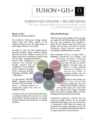
- 1. FUSION + GIS + FUSION+GIS+ONUMA = BIG BIM BANG The Entire State of California Community College System in a Cloud Computing Environment Lift Off 3.11.11 March 11, 2011 What This Will Enable Pasadena & Sacramento, California California Community Colleges will now be able The California Community College System to visualize 2D and 3D floor plans with FUSION (CCC) serves 2.75 million students at 112 data that was previously only accessible in California locations and is the largest system of tabular format. Dynamic data driven floor plan public higher education in the world. graphics and site plans will allow for pattern recognition, better decision making and On March 11, 2011 the CCC FUSION System accounting of valuable facilities and assets. (Facilities Utilization, Space Inventory Options Net) with the entire California inventory of 71 Data visualization serves as a quality check -- million square feet of buildings and spaces, along highlighting discrepancies and creating a self with the CCC Geographic Information correcting mechanism. Traditional System (GIS) Collaborative of methods of retrieving up to date campuses and buildings was floor plans and data are mired in brought together with the “middleware” of the ONUMA FUSION ONUMA inefficient processes that are difficult to access. California System, making it the largest Community Colleges can cloud computing Building become the leader in Information Modeling (BIM) managing facilities with the + GIS platform. 3.11.11 latest in 21st century tools. DATA BIM In a split second a “BIG BIM Planning of new facilities can BANG” happened between work with historically FUSION+GIS+ONUMA to accurate information from the create a combined platform to GIS FUSION+GIS+ONUMA Platform dramatically expand the value of data and floor plans. One result could FUSION for CCC. be cost effective Initial Project Proposals (IPPs), Final Project Proposals (FPPs), and other A wealth of CCC and related facility information predesign planning being produced locally. is accessible visually and in real time in a simple online platform thereby saving time and money Furthermore contractors working with the through automated synchronization of multiple community college districts can be provided databases. integrated facility data to start new construction or renovations in BIM. Once the projects are completed the as-built information can be fed back into the FUSION+GIS+ONUMA Platform to support operations and maintenance. FUSION+GIS+ONUMA = The Next BIG BANG 1| 6
- 2. FUSION + GIS + The first districts to demonstrate the new FUSION+GIS+ONUMA integration are: • Citrus CCD • Foothill-De Anza CCD • Long Beach CCD • Los Rios CCD • Rancho-Santiago CCD • Sequoias CCD Level 1 The initial launch of the FUSION+GIS+ONUMA With in-kind services for the demo provided by: Platform includes the entire state’s data of • San Joaquin Delta CCD classrooms placed in the proper geographic • South Orange County CCD location adjacent to the campus property line. FUSION manages the web based data of 71- million square feet of facilities in the California Community College System. FUSION tracks the condition assessments and develops cost modeling for maintenance projects, enabling colleges to plan budgets and help facilitate the passing of much-needed bond measures. Level 2 The ONUMA System provides award-winning The six districts initially demonstrating the cloud computing integration that supports the FUSION+GIS+ONUMA Platform will also have full life-cycle of facilities and enables users to the campus building footprints from GIS placed view graphics and real-time data on the web. It in the proper locations and spaces from FUSION combines the best of BIM, GIS, and open will be placed in the buildings. standards systems acting as a middleware to enable visualization of complex data in a simple format. The ONUMA System is used from early planning to facility management; it links to other systems through web services and open standards exchanges such as CSV, KML, BIM IFC, COBie, XML and other formats. Level 3 Four Levels of Detail One building from each of the initial districts will The goal of the FUSION+GIS+ONUMA also have the actual layout of the building based Platform is to have the entire state at Level 3. on floor plans with rooms from FUSION. The initial goal was to have the entire FUSION System, which has a common naming and Future Capability numbering system for the entire state, linked to Level 4 the ONUMA System at Level 1. This strategy The ONUMA System has other capabilities built allowed for immediate functionality using the into it like viewing and editing room level FUSION data as a common foundation to furniture and equipment. As a middleware it also continually update the rest of the building as the links to other BIM, CAD and GIS Systems. This data is collected in the future. Users with proper capability is available for future use. access will be able to view and analyze data. FUSION+GIS+ONUMA = The Next BIG BANG 2| 6
- 3. FUSION + GIS + Functionality of FUSION+GIS+ONUMA Platform Individual User Log In The pilot phase of this project will provide each district with 60 days of free access to the FUSION+GIS+ONUMA Platform. Districts have the flexibility of beginning the 60 day trial at their convenience. Each user has access to the proper level of detail of graphics and data. They can view or edit through a web browser, installing no software. This strategy allows “viewers” to see data live as it is made available by editors and administrators of the system. Entire State Portfolio Level View View all campus sites as links on a web-based map. Everything can have a latitude and longitude down to the piece of equipment in a room. This is not a trivial accomplishment and makes real, the connection of building models and GIS in a tangible way, thus enabling location based tracking of information across the entire portfolio. Campus Site Plans With proper access levels, clicking on a dot opens the site plan and building footprints of that campus, live links to geographic data from Google Earth and the CCC GIS Collaborative Server along with color coded building plans and other live elements from FUSION data. Building Floor Plans Floor plans that are traditionally managed in static CAD or PDF plans are made live. As data changes in FUSION it will change the graphics in the floor plans. This strategy is what will allow the data to live and be accurate over time, rather than having to constantly update it manually. Space Floor Plans It is also possible to layout and plan for new spaces, furniture, equipment or manage existing spaces. This is a Level 4 detail that is available in the system but will not be used in the initial development. Reports and Analysis Reports can be generated directly from the graphics. FUSION data can also be shown in these reports. Data can also be exported in many open standard formats such as Google Earth, BIM via IFC and BIMXML, COBie, OGC OWS4, CSV or EXCEL Tables. FUSION+GIS+ONUMA = The Next BIG BANG 3| 6
- 4. FUSION + GIS + Technical Requirements One of the most powerful aspects of the FUSION+GIS+ONUMA Platform is that any computer with access to the internet can be used and software installation is not needed to start interacting with the data. In the past, complex desk bound PC systems required expensive software and training to get to basic information. Those barriers are removed with the FUSION +GIS+ONUMA Platform. This allows both technical and non-technical users to work from their platform of choice with minimal hardware requirements and software training. Operating Systems and Web Browsers Firefox, Chrome or Internet Explorer 8 and later on Windows Safari, Firefox, Chrome on MacOS X Plug-ins to view additional 2D and 3D graphics Adobe Flash Google Earth Plug In Graphisoft GDL Web Control - Version 13 iPad, iPhone and Android The explosion of smart phones and apps on iPhones and Androids demonstrates the need to use simple tools to view and analyze data. The solution shown here supports all of this and more. The iPhone and Android UI can view and edit some data, and view 2D Graphics. This can also be used for field collection of data directly into the ONUMA System. Links to Other Tools Excel ArchiCAD Autocad Revit Autodesk Vasari Autodesk Ecotect Trelligence Google SketchUp (Free and Pro Version) Google Earth (Free and Pro Version) ArcGIS Open Industry Standards buildingSMART alliance Industry Foundation Classes (IFC) Open Geospatial Consortium (OGC) World Wide Web Consortium (W3C) Green Building XML (gbXML) Construction Operation Building Information Exchange (COBie) REST and SOAP Web Services FUSION+GIS+ONUMA = The Next BIG BANG 4| 6
- 5. FUSION + GIS + CLOUD CLOUD COMPUTING The Internet has changed everything. Smart phones and location aware services allow instant and easy access to complex relevant real-time FACILITY information with little or no training. The old model of “importing” all data into one monster desktop bound system is rapidly dying. The new model of using the Internet DOCS and “services” to subscribe to information that is the authoritative source is the scalable solution for complex data. FUSION+GIS+ONUMA linked together as cloud based services make this a reality for the California Community CAD Colleges. This initial implementation provides exponential OPEN value but is really just the tip of the iceberg as more FUSION functionality is added in simple and economical way as needed. MIDDLEWARE With FUSION as the master repository of facility data, GIS mapping the location of campuses and DATA buildings and ONUMA as the integrating middleware bringing it all together -- the FUSION+GIS+ONUMA GIS platform is born. OPEN STANDARDS Just like the Internet is not one web site, the FUSION+GIS+ONUMA Platform is not created ONUMA BIM around one solution. The complexities of 21st century facilities cannot be managed by any single monolithic software. APPS The use of open standards will support plugging and playing different systems. Avoiding proprietary locked FUTURE systems will future-proof the data being managed for the California Community Colleges. ENERGY As new needs arise they can be added as modules to the system. The FUSION+GIS+ONUMA Platform builds the initial infrastructure for this open standards implementation and invites collaborators and future competitors to enhance the capabilities of this ecosystem. We challenge the industry to plug in and share. FUSION+GIS+ONUMA = The Next BIG BANG 5| 6
- 6. FUSION + GIS + Information and graphics Uses Data connected to graphics makes it easier to rapidly analyze and make decisions with information. The FUSION+GIS + O N U M A P l a t fo r m Building Information Modeling (BIM) ser ves many users. 4,000 buildings from the entire state are available at varying levels of Regardless of what your detail, ready to be opened in tools like Revit, Archicad, Bentley, interest is the data in Vectorworks, Onuma and other BIM applications. the Platform can s u p p o r t yo u i n a n Geographic Information Systems (GIS) accessible and easy to Every piece of data is referenced to a geographic location and can be understand format. analyzed in various GIS applications. All buildings can be opened and viewed in Google Earth. Facility Management (FM) Data is formatted to be used by FM systems. All buildings can be exported in the open standard COBie format. Computer Aided Design (CAD) 2D and 3D data for the entire state is now connected to graphics which can be accessed in a simple format. Three Dimensional Models FUSION Buildings can be viewed in 3D and exported to other formats such as Google SketchUp and BIM. Connect with Open Standards The platform is set up to allow exporting and importing data with open standards exchanges such as IFC, XML, COBie, KML, CSV and other formats. GIS Web Services and the Cloud Other systems can also connect through web services. In the same way that FUSION is connected to ONUMA System live through webservices, other systems could also connect. ONUMA For More Information http://www.foundationccc.org/WhatWeDo/FUSION/tabid/76/Default.aspx http://cccgis.org http://ONUMA.com/FUSION BIG BIM little bim: http://www.4sitesystems.com FUSION+GIS+ONUMA = The Next BIG BANG 6| 6