
Recomendados
Recomendados
Mais conteúdo relacionado
Mais procurados
Mais procurados (18)
Semelhante a Re-Imagining a More Sustainable Cleveland 2.0
Semelhante a Re-Imagining a More Sustainable Cleveland 2.0 (20)
Mais de marianneep
Mais de marianneep (20)
Último
Último (6)
Re-Imagining a More Sustainable Cleveland 2.0
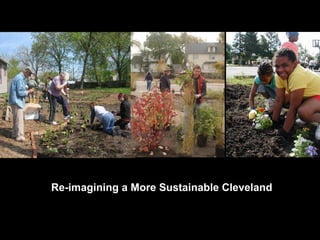
- 1. Re-imagining a More Sustainable Cleveland
- 2. Decentralization The Cleveland Akron Metropolitan area contains 26% of the states population, while encompassing less than 9% of the land area in the state The pattern in Cuyahoga county and many metro areas nationally has been one of sprawling developments that fail to create appropriate densities in the right locations and begin to compromise rural environments and create decay in urban areas.
- 5. Land Utilization Connecting Cleveland 2020 Comprehensive Plan Future Existing The Vision The Reality 20,000 Vacant Lots Citywide
- 6. Existing Land Use Future Land Use HOLDING STRATEGY PRESERVATION STRATEGY Vacant Land Foreclosures Population decline Targeted demolition Contaminated land left from industrial exodus
- 9. Re-Imagining Cleveland Vacant Land Study Goal: Reuse vacant land to make Cleveland a cleaner, healthier, more beautiful, environmentally and economically sound city.
- 11. Land Bank Decision Making Flow Chart – Developed by City Planning Department and Adopted by the City of Cleveland Planning Commission in December, 2008
- 12. The word “neighborhood” gets tossed around a lot in real estate brochures, so it is important to be clear what it means. Each neighborhood has a center and an edge. The center should be a public space, whether a square, a green, or an important intersection.
- 13. The optimal size of a neighborhood is a quarter-mile from center to edge. For most people, a quarter mile is a five-minute walk. For a neighborhood to feel walkable, many daily needs should be supplied within this five-minute walk. That includes not only housing, but stores, workplaces, schools, houses of worship, and recreational areas.
- 14. Typical retail area under normal conditions Build up instead of out Lighting, trees, awnings, and crosswalks High Density, Mixed-Use, Pedestrian Friendly District: Promoting activity, employment, convenience, and a sense of safety BUILDING ON STRENGTHS Re-establish the competitiveness of Cleveland’s neighborhood retail districts by building upon their traditional strengths as pedestrian-oriented, mixed-use districts with distinctive architectural character
- 16. 0-5 year development focus
- 17. 5-10 year development focus
- 18. 10-15 year development focus
- 19. 15-20 year development focus
- 20. Mapping: Vacancy and Existing Greenspace
- 21. Mapping: Impervious Surfaces impervious surfaces
- 22. HOLDING STRATEGIES In future development areas
- 23. GREEN INFRASTRUCTURE Neighborhood-scale riparian strategy
- 24. GREEN INFRASTRUCTURE Restoration of natural systems watersheds
- 25. GREEN INFRASTRUCTURE Remediation strategies Phytoremediation is a process that uses plants to remove contaminants from soil.
- 26. Mapping: Urban Farms and Community Gardens Freddy L. Collier
- 27. PRODUCTIVE LANDSCAPES Urban Agriculture and Energy Generation Freddy L. Collier
- 28. Re-Imagining Cleveland Resources Pattern Book Identifies and illustrates a suite of reuse strategies. The Ohio Greenprint: A free online user-friendly GIS mapping tool used for community land reuse planning Reimaginingcleveland.org An interactive website to shine a spotlight on our first Land Reuse Heroes and to share successes and challenges, stories, photos, resources and learn of upcoming events and workshops .
- 30. Re-Imagining Cleveland Projects 56 projects totaling 15 acres of vacant land
- 32. Citywide Vacant Land Action Plan & Implementation Strategy Re-Imagining 2.0
- 34. Gathering Expertise Signature Projects Prioritized Implementation Decision Process Steering Committee Working Group Alternative Energy Generation Urban Agriculture Stormwater Management Contamination Remediation Greenspace Expansion Land Assembly for Development Stabilization Sustainable Development Pattern Freddy L. Collier
- 36. Promoting Prosperity, Health, and Community through the sustainable reuse of our vacant land resources Urban Agriculture Contamination remediation Vacant Land Stabilization Land Assembly for development Greenspace expansion Sustainable development pattern Alternative Energy Generation Community, Prosperity, Health Stormwater Management Freddy L. Collier
- 37. The Region Older suburbs have suffered as new ones continue to spring up, skimming off tax; in northeast Ohio this includes many of our first ring suburbs
- 38. City & County Land Bank City of Cleveland Land bank Cuyahoga County Land bank
- 39. Rehabilitation
- 41. Ideas for vacant land reuse in Cleveland 8
- 44. Greenspace Expansion
- 46. ECO BOULEVARD
- 50. West 25 th West Side Market area
- 51. Terraced Parks and High Density TOD
- 53. Land Assembly
- 54. Opportunity Corridor Area: urban agriculture Zone and support uses could include stormwater management, green grocery store, urban agricultural education, vineyards, all linked by a transit corridor.
- 55. Provide green infrastructure, systems level and small scale BMPs in stormwater management, and alternative energy options for new and existing businesses in opportunity corridor. Design the Opportunity Corridor in such a way that will make it the greenest street in northeast Ohio taking full advantage of adjacent vacant land.
- 58. Stormwater Park incorporate into new developments
- 60. Alternative Energy Power generation for businesses an communities Spring Road Alternative Energy
- 61. East 55 th & Shoreway
- 62. Stabilization
- 64. East 105 th & Superior Stabilization
- 73. Linking CSO level activity with neighborhood level BMP’s to impact stormwater volume and quality. Identify stormwater interventions for new investment (water & housing model Philadelphia) Kerruish Park Stormwater
- 74. Re-imagining a More Sustainable Cleveland
- 75. Cleveland Plain Dealer August 19 th 2007 Providing opportunities for people who are least empowered but most impacted Freddy L. Collier
- 76. www.ReImaginingCleveland.org www.ohiogreenprint.org www.planning.cleveland.oh.us Re-imagining a More Sustainable Cleveland For more information please visit:
Notas do Editor
- The Vision in connecting Cleveland 2020 assumes that we will grow again and what is that desired state that we want to move toward.
- The reality is that we have to respect the fact that we are declining in the interim and if we are it is imperative that we utilize our land resources in a sustainable way setting the table long term growth. Housing is one of the key issues we face regarding use of our land resources. Foreclosure, demolitions, and vacant land are the result of a failed housing market. We are now forced to revisit our housing layer to determine how vacant property and vacant land reutilization has impacted us in the near term.
- This decision tool was developed By City Planning in context of Re-imagining Cleveland. It was adopted in Dec. 2008 and is used for vacant land use planning throughout the City. It accounts for many factors including existing greenspace, development potential and riparian areas to name a few.
- A five-minute walk will take you further on a grid pattern with good sidewalks than on a cul-de-sac pattern with difficult pedestrian crossings. Thus, street layout has a major impact on how many people fit within the “pedestrian shed” for a neighborhood center.
- This is another map that was created through the process. This map shows where our existing community and gardens and urban farms are. The green circles are 1/4 mile buffers around the gardens sites. The Goal in Cleveland is to have every person within ¼ mile of a growing space. Maps like this can help people to decide where to locate new growing sites in order to bring more people within walking distance to local food.
- Aside from the Study, additional resources were also created. The pattern book was created to help inspire neighborhood residents and community development corporations as they envision, plan and implement reuse projects. The Pattern or Idea Book offers budgets, site plans and resources for a variety of short term and long term projects. In the coming months the Pattern Book will undergo a makeover – It will be reformatted into Idea Sheets that offer similar information in a user friendly less paper consumptive way.
- Once the study was complete, Re-imaginging Cleveland moved into the next phase with the Competitive Grant Program. The City of Cleveland and NPI received over 110 grant applications from individuals, neighborhood groups, businesses, non profits and church groups throughout the City. The grants were reviewed by a panel of expert reviewers and scored according to many factors including prior land use, organizational capacity, visibility, and social and environmental benefit. In the end 56 projects were granted funds. 30 ag. projects and 26 greening projects.
- Map of the projects. In the selection process we attempted to spread the granted projects throughout the City. You notice some areas have not projects – these are non-nsp areas. Also, you see clusters- this is where there is the most vacant land.
- To help create a cohesive NE Ohio Local Food Network that leverages the energy and knowledge of our community, CCLFPC, and partners are spearheading the NE Ohio Local Food Assessment. The assessment is underway as we speak. The goals of the quick paced process are to document the current state of our system, Analyze the feasibility and impact of expanding our system Develop a strategic placed based plan to strengthen our system while remaining flexible and responsive to the growers and eaters of our region. So far, the assessment is attaching numbers and strategy to great ideas, most of which have come from the grass roots grower level, such as A certified community kitchen for food processing of value added products. A farm incubator that can offer a leg up to entrepreneurs by providing shared tools, shared common space and secure growing space. The assessment is also tackling the hard to solve issues that many of you have expressed through Cleveland 2019 and other regional listening and planning meetings…issues like job training and scale verus economic pay back, Season extension and market development. The assessment should be complete by years end. We hope that it can be added to the Re-imagining Cleveland vacant land program to create a comprehensive road map for the local food movement as we build strong networks that will be needed to create a local food system.
- To help create a cohesive NE Ohio Local Food Network that leverages the energy and knowledge of our community, CCLFPC, and partners are spearheading the NE Ohio Local Food Assessment. The assessment is underway as we speak. The goals of the quick paced process are to document the current state of our system, Analyze the feasibility and impact of expanding our system Develop a strategic placed based plan to strengthen our system while remaining flexible and responsive to the growers and eaters of our region. So far, the assessment is attaching numbers and strategy to great ideas, most of which have come from the grass roots grower level, such as A certified community kitchen for food processing of value added products. A farm incubator that can offer a leg up to entrepreneurs by providing shared tools, shared common space and secure growing space. The assessment is also tackling the hard to solve issues that many of you have expressed through Cleveland 2019 and other regional listening and planning meetings…issues like job training and scale verus economic pay back, Season extension and market development. The assessment should be complete by years end. We hope that it can be added to the Re-imagining Cleveland vacant land program to create a comprehensive road map for the local food movement as we build strong networks that will be needed to create a local food system.
- Thank you!