Submit Search
Upload
20140502 asia fabcup_atfab1
•
1 like
•
762 views
Taichi Furuhashi
Follow
Technology
Business
Slideshow view
Report
Share
Slideshow view
Report
Share
1 of 21
Download now
Download to read offline
Recommended
In the tragic aftermath of the earthquake in Port-au-Prince in January 2010, members of the OpenStreetMap and OSGeo communities rallied to produce geographic data that directly assisted humanitarian aid workers in the rescue of disaster victims.
How Crowdsourcing Changed Disaster Relief Forever
Schuyler Erle
Maptivism reloaded: Open Data for Development @oddc
Christian Kreutz
Presentation at the 2015 ICMA Conference in Seattle, WA. GIS management best practices panel.
From the Emerald City to Your City GIS for Effective Service and ROI
Greg Babinski
These are my slides for the Visweek 2009 panel "Changing the world with visualization", organized by Robert Kosara with Sarah Cohen, Martin Wattenberg and myself.
Changing the world with visualization
Jérôme Cukier
This is a presentation I did in class on Google Earth. The animation had to be deleted in order to make space for the PowerPoint
Modified Resource Google Presentation
William Worford
Computer games
Computer games
mbeilharz
11 13 Gis
11 13 Gis
Fauquier Horticulture
iPad Atlas is very easy and economiy system for high school geography education. The author tried field test at Sendai,the Tsunami dangered area with local teachers. This presentation is did at Association of Japanese Geography education,in August 25.
iPad atlas ver.1.1
iPad atlas ver.1.1
Tomoaki Ito
OpenStreetMap mobile tools & visualisation
Tua Sarocha
It is a presentation on Natural disaster, Its type and the technologies that can be used to prevent the loss. It is mainly made for students which is easily understandable to them.
Technologies for natural disaster
FerdinandAlickCastel
Utilizing Citizen Science for Supporting Geospatial Applications @ AAG2015-Chicago 2015.04.22
Aag2015 seto
Aag2015 seto
Toshikazu Seto
Geocollaboration at São Paulo State University, Brazil - presentation at ICA Neocartography/Map Design workshop, Dresden Aug 2013
Arlette Meneguette
Arlette Meneguette
Steve Chilton
Guestlecture at Wageningen University, Course GRS-32806 Spatial Data Infrastructure, 1 feb 2017. https://ssc.wur.nl/Studiegids/Vak/GRS-32806
On Spatial, Data and Mapping myopia
Jan Willem van Eck
Palestine West Bank Free Map Introduction
guest6d104a
Palestine West Bank Free Map Introduction
mikel_maron
MapWarper O'Reilly Ignite Talk, Where2.0 about crowd sourced open source map geo rectifier
MapWarper O'Reilly Ignite Talk, Where2.0
chippy
Delivered to the BCS Data Management forum, an overview of GIS/Geospatial trends, the need for spatial integrity, why spatial intelligence doesn't need a map, and creative curveballs like the enduring benefits of analog tools and handmade craftsmanship.
Spatial is (not) special - Adventures in location-based data
Thierry Gregorius
Presentation given at the Royal Geographical Society, 18 MArch 2016
Mobile Apps for Fieldwork
James Millington
IDRiM 2017 in Reykjvik
Generation from Information to Knowledge in Disaster Response- Based on info...
Tadashi Ise
Smart City with GIS
Smart City with GIS
Athulya Ganapathi Kandy
State of the Map, Limerick
FreeMapIndia 2008, part 2
mikel_maron
Smart City is an trending Project in todays world. This document provides you an platform of using GIS software in these kind of project.
Smart city and gis
Smart city and gis
Ravi Shrestha
Google Earth Engine is a powerful geospatial analysis tool that allows end users to leverage the power of the Cloud to work with big data in remote sensing. While lesser known than its cousin Google Earth, Earth Engine has many advantages for prospective users beyond data visualization including: data manipulation, statistical analysis, and development of custom tools for project specific tasks. Earth Engine maintains a wealth of public datasets for users to work with such as Landsat imagery, Digital Elevation Models, and high-resolution aerial imagery. As part of a USDA funded research project at Middle Tennessee State University, Google Earth Engine was used to collect and process hundreds of Landsat images. These images were used to measure crop growth curves which will aid in the development of crop-land-cover GIS datasets for years in which data is unavailable to stakeholders.
Digital Projects Showcase: Google Earth Engine
Wesley Porter
Insight that you can crete your own google maps with some open source tech already available on the market.
Google maps replacement with python
Christoforus Surjoputro
Keukenhof Gardensin Holland
Piebel
Ambar Y Oriela 7ºa
Ambar Y Oriela 7ºa
guest78b26b
Presentation given at the NIST Workshop on Dexterous Manipulation, Automate Show 2013.
Useful Robot Dexterity for the Factory
Samuel Bouchard
Essay about how the traditional ad industry is changing to produce campaigns that give consumers the power to remix (and spread) content for clients.
Remixable Advertising
Werner Iucksch
Lesson 7 1 Part 2 1
Lesson 7 1 Part 2 1
mradcliffe
Plan template for sales kickoff theme and content. Designed to engage 1000+ sales reps and engineers for 3-4 full days.
Sales Kickoff Plan
Sales Kickoff Plan
Özer Dondurmacıoğlu
More Related Content
What's hot
OpenStreetMap mobile tools & visualisation
Tua Sarocha
It is a presentation on Natural disaster, Its type and the technologies that can be used to prevent the loss. It is mainly made for students which is easily understandable to them.
Technologies for natural disaster
FerdinandAlickCastel
Utilizing Citizen Science for Supporting Geospatial Applications @ AAG2015-Chicago 2015.04.22
Aag2015 seto
Aag2015 seto
Toshikazu Seto
Geocollaboration at São Paulo State University, Brazil - presentation at ICA Neocartography/Map Design workshop, Dresden Aug 2013
Arlette Meneguette
Arlette Meneguette
Steve Chilton
Guestlecture at Wageningen University, Course GRS-32806 Spatial Data Infrastructure, 1 feb 2017. https://ssc.wur.nl/Studiegids/Vak/GRS-32806
On Spatial, Data and Mapping myopia
Jan Willem van Eck
Palestine West Bank Free Map Introduction
guest6d104a
Palestine West Bank Free Map Introduction
mikel_maron
MapWarper O'Reilly Ignite Talk, Where2.0 about crowd sourced open source map geo rectifier
MapWarper O'Reilly Ignite Talk, Where2.0
chippy
Delivered to the BCS Data Management forum, an overview of GIS/Geospatial trends, the need for spatial integrity, why spatial intelligence doesn't need a map, and creative curveballs like the enduring benefits of analog tools and handmade craftsmanship.
Spatial is (not) special - Adventures in location-based data
Thierry Gregorius
Presentation given at the Royal Geographical Society, 18 MArch 2016
Mobile Apps for Fieldwork
James Millington
IDRiM 2017 in Reykjvik
Generation from Information to Knowledge in Disaster Response- Based on info...
Tadashi Ise
Smart City with GIS
Smart City with GIS
Athulya Ganapathi Kandy
State of the Map, Limerick
FreeMapIndia 2008, part 2
mikel_maron
Smart City is an trending Project in todays world. This document provides you an platform of using GIS software in these kind of project.
Smart city and gis
Smart city and gis
Ravi Shrestha
Google Earth Engine is a powerful geospatial analysis tool that allows end users to leverage the power of the Cloud to work with big data in remote sensing. While lesser known than its cousin Google Earth, Earth Engine has many advantages for prospective users beyond data visualization including: data manipulation, statistical analysis, and development of custom tools for project specific tasks. Earth Engine maintains a wealth of public datasets for users to work with such as Landsat imagery, Digital Elevation Models, and high-resolution aerial imagery. As part of a USDA funded research project at Middle Tennessee State University, Google Earth Engine was used to collect and process hundreds of Landsat images. These images were used to measure crop growth curves which will aid in the development of crop-land-cover GIS datasets for years in which data is unavailable to stakeholders.
Digital Projects Showcase: Google Earth Engine
Wesley Porter
Insight that you can crete your own google maps with some open source tech already available on the market.
Google maps replacement with python
Christoforus Surjoputro
What's hot
(16)
OpenStreetMap mobile tools & visualisation
Technologies for natural disaster
Aag2015 seto
Aag2015 seto
Arlette Meneguette
Arlette Meneguette
On Spatial, Data and Mapping myopia
Palestine West Bank Free Map Introduction
MapWarper O'Reilly Ignite Talk, Where2.0
Spatial is (not) special - Adventures in location-based data
Mobile Apps for Fieldwork
Generation from Information to Knowledge in Disaster Response- Based on info...
Smart City with GIS
Smart City with GIS
FreeMapIndia 2008, part 2
Smart city and gis
Smart city and gis
Digital Projects Showcase: Google Earth Engine
Google maps replacement with python
Viewers also liked
Keukenhof Gardensin Holland
Piebel
Ambar Y Oriela 7ºa
Ambar Y Oriela 7ºa
guest78b26b
Presentation given at the NIST Workshop on Dexterous Manipulation, Automate Show 2013.
Useful Robot Dexterity for the Factory
Samuel Bouchard
Essay about how the traditional ad industry is changing to produce campaigns that give consumers the power to remix (and spread) content for clients.
Remixable Advertising
Werner Iucksch
Lesson 7 1 Part 2 1
Lesson 7 1 Part 2 1
mradcliffe
Plan template for sales kickoff theme and content. Designed to engage 1000+ sales reps and engineers for 3-4 full days.
Sales Kickoff Plan
Sales Kickoff Plan
Özer Dondurmacıoğlu
Uss Nebraska Submarine Embark November2008
Luis Nassif
Kikkers
Kikkers
Piebel
Painting, Art
Anna kostenko
Anna kostenko
Piebel
Analytical research about volunteering in Poland: Acknowledgments and PR
Volunteering in Poland
gurtrc
20151030 富士通SS研 講演予定資料 @ 神戸
Taichi Furuhashi
GITA-JAPAN 2012
GITA-JAPAN: Power of NeoGeographer
Taichi Furuhashi
vida de un rider
illness.
illness.
El Cobos
The aim of this collaborative 3D printing workshop is to define the production specifications, the teaching-learning pedagogical strategy aspects to help architecture students acquire: the basic competences of building representation, the pre and post processing of printing procedures (printing materials, paint, epoxy, accessories, etc...), defining the missing functions in BIM and Architectural Modelling software and determining the benefits of enhancing them for better 3D prototyping productivity. Two teams (A and B) adopted specific working scenarios based on real world printing jobs. Team A worked on an in-house scenario and Team B on an outsourcing scenario. Tasks successfully completed showed: the wide range of prototypes that could be produced in an architectural studio and the need for a collaborative network to organize the knowledge and good practices developed by research teams (professional or academic) involved in developing rapid prototyping for architecture. This knowledge network could be a discussion forum and a development partnership of 3D printing manufacturers and CAD/BIM software developers.
Collaborative 3D Modelling and Printing: What you See is not Directly What Yo...
Farid Mokhtar Noriega
RajeevKumarK
RajeevKumarK
aqua25ind
Hi France24 Iht Harris Poll Leaders Barometer April2009
Luis Nassif
Relatorio Final11893 2
Luis Nassif
Cdocuments And Settingsvoliveiradesktopapensos 2
Luis Nassif
20110712 国土交通大学校 地理空間情報活用〔産官学連携〕研修
Taichi Furuhashi
Ping Chen China Approach909
Luis Nassif
Viewers also liked
(20)
Keukenhof Gardensin Holland
Ambar Y Oriela 7ºa
Ambar Y Oriela 7ºa
Useful Robot Dexterity for the Factory
Remixable Advertising
Lesson 7 1 Part 2 1
Lesson 7 1 Part 2 1
Sales Kickoff Plan
Sales Kickoff Plan
Uss Nebraska Submarine Embark November2008
Kikkers
Kikkers
Anna kostenko
Anna kostenko
Volunteering in Poland
20151030 富士通SS研 講演予定資料 @ 神戸
GITA-JAPAN: Power of NeoGeographer
illness.
illness.
Collaborative 3D Modelling and Printing: What you See is not Directly What Yo...
RajeevKumarK
RajeevKumarK
Hi France24 Iht Harris Poll Leaders Barometer April2009
Relatorio Final11893 2
Cdocuments And Settingsvoliveiradesktopapensos 2
20110712 国土交通大学校 地理空間情報活用〔産官学連携〕研修
Ping Chen China Approach909
More from Taichi Furuhashi
© mapconcierge, CC BY-SA 4.0
JICA Training 2018, Power of NeoGeographer
Taichi Furuhashi
Learning Beyond Boundaries. Collaboration Beyond Differences. --- http://www.gsc.aoyama.ac.jp #AoyamaGSC #AoyamaJSP #Aogaku #地球社会共生学部 #青学
School of Global Studies and Collaboration 2019, AOYAMA GAKUIN UNIVERSITY
Taichi Furuhashi
青山学院大学 AOYAMAスタンダード(教養) 「情報社会論」講義資料 © mapconcierge, CC BY-SA 4.0
情報社会論#10 "ソフトウェアのライセンス"
Taichi Furuhashi
Center for Spatial Information Science. Several universities have formed GESTISS to make collaboration in advanced social service research and develop personnel who can take leadership in managing projects. http://gestiss.org/event/detail?id=31
Git-it Getting started about GitHub
Taichi Furuhashi
2016/03/26-27開催の龍野マッピングパーティー
20160327 龍野マッピングパーティー
Taichi Furuhashi
2016-03-07 NPO法人静岡情報産業協会 ITセミナー http://www.siia.or.jp/archives/2427 https://speakerdeck.com/mapconcierge/ingressdedi-yu-huo-xing-jing-gang-shi-wohackseyo-number-jing-gang-shi-xingress #静岡市xINGRESS #Ingressは仕事です
Ingressで地域活性 静岡市をHACKせよ! #静岡市xINGRESS
Taichi Furuhashi
http://www.tsukutama.info/ 埼玉県内を中心に活動する、まちづくりの専門家集団・特定非営利活動法人「つくたま」
20160115 つくたま塾
20160115 つくたま塾
Taichi Furuhashi
20160126 CSISi - G空間プラットフォームの民間開放に向けて 青山学院大学 地球社会共生学部 古橋プレゼン資料 http://i.csis.u-tokyo.ac.jp/news/20160126/ © mapconcierge, CC BY-SA 4.0
オープンストリートマップに続く、 新しいネオジオグラファーの胎動
Taichi Furuhashi
Nazakicho Mapping Party @ VISIONS OSAKA 2016
20160110 中崎町マッピングパーティー
Taichi Furuhashi
http://eventdots.jp/event/575585 2015/12/19
Open or Die @ GitHub patchwork tokyo
Taichi Furuhashi
© mapconcierge, CC BY-SA 4.0
20151211 未来研究トーク@Nii
Taichi Furuhashi
これからのドローンの話をしよう ~ WEEK神山を三次元計測するゾ! ~ --- 青山学院大学 地球社会共生学部 古橋 大地 https://github.com/dronebird/droneworkshop20151206kamiyama
DRONE WORKSHOP @ WEEK神山 #4K神山
Taichi Furuhashi
20151127 G空間EXPO SPACシンポジウム 市民が作るオープンなバリアフリーマップ Wheelmap.org http://www.eiseisokui.or.jp/ja/forum/symposium2015_guide.php
20151127 Wheelmap.org G空間EXPO SPACシンポジウム
Taichi Furuhashi
https://readyfor.jp/projects/dronebird 思い出してほしい。映画やアニメの世界で、大災害が起きたとき、街や地球が危機に陥ったとき、そのピンチを救ってくれる救援部隊やヒーローたちのことを。政府組織や国際機関に属しているわけではなく、自分たちの意思で、みんなを守ってくれる謎のチーム。その秘密基地には、最新技術が並び、メンバーたちが世界中の地図や情報を見つめ、地球に危機が訪れないか、常に見張っている。そして、緊急事態には、その基地から即座に、特別なマシンたちが出動し、助けを求める人々がいるところへと向かっていく。 これを、映画の世界の話ではなく、現実の世界の話にする、ひとつの計画が日本で動き出した。その名も「災害ドローン救援隊 DRONE BIRD(ドローンバード)」だ。その計画は、ハイチや東日本大震災をはじめ、災害後の地図づくりを牽引してきた、日本を代表するマッパー、古橋大地の想いから始まった。
災害ドローン救援隊 DRONE BIRD @ G空間EXPO
Taichi Furuhashi
Speech on G-SPASE Monthly Tutorial © mapconcierge, CC BY-SA 4.0
20151115 Open or Die @ G-SPASE
Taichi Furuhashi
青山学院大学 地球社会共生学部 古橋 @mapconcierge 1.ドローンとは何か? 2.日本の法規制とリスク 3.ドローンビジネス 4.ドローンと人道支援 ・Humanitarian OpenStreetMap ・CrisisMappers Japan ・UAviators ・OpenDroneMap ・OpenAerialMap 5.これからのドローンのあるべき姿
これからのドローンの話をしよう
これからのドローンの話をしよう
Taichi Furuhashi
平成27年度JICA集団研修「国家測量事業計画・管理」コース講義 講師:古橋大地(青山学院大学 地球社会共生学部 教授) License: © MAPconcierge, CC BY-SA 4.0
「Power of NeoGeographer」Lecture
Taichi Furuhashi
Lecture04: Mapping Safecast Class 2015 @ GSC, AGU https://hackpad.com/Safecast-Class-2015-GSC-AGU-RKQpYzLWLdy
Safecast Class 2015 @ GSC, AGU "Mapping"
Taichi Furuhashi
#すごい地理教育 http://togetter.com/li/887864
20151016 すごい地理教育トーク 古橋
Taichi Furuhashi
9月23日(水・祝)Ingressで地域活性 国立市の天下市に向けて http://chika-ba.com/?p=232
Ingress x 国立・天下市
Ingress x 国立・天下市
Taichi Furuhashi
More from Taichi Furuhashi
(20)
JICA Training 2018, Power of NeoGeographer
School of Global Studies and Collaboration 2019, AOYAMA GAKUIN UNIVERSITY
情報社会論#10 "ソフトウェアのライセンス"
Git-it Getting started about GitHub
20160327 龍野マッピングパーティー
Ingressで地域活性 静岡市をHACKせよ! #静岡市xINGRESS
20160115 つくたま塾
20160115 つくたま塾
オープンストリートマップに続く、 新しいネオジオグラファーの胎動
20160110 中崎町マッピングパーティー
Open or Die @ GitHub patchwork tokyo
20151211 未来研究トーク@Nii
DRONE WORKSHOP @ WEEK神山 #4K神山
20151127 Wheelmap.org G空間EXPO SPACシンポジウム
災害ドローン救援隊 DRONE BIRD @ G空間EXPO
20151115 Open or Die @ G-SPASE
これからのドローンの話をしよう
これからのドローンの話をしよう
「Power of NeoGeographer」Lecture
Safecast Class 2015 @ GSC, AGU "Mapping"
20151016 すごい地理教育トーク 古橋
Ingress x 国立・天下市
Ingress x 国立・天下市
Recently uploaded
The value of a flexible API Management solution for Open Banking Steve Melan, Manager for IT Innovation and Architecture - State's and Saving's Bank of Luxembourg Apidays New York 2024: The API Economy in the AI Era (April 30 & May 1, 2024) ------ Check out our conferences at https://www.apidays.global/ Do you want to sponsor or talk at one of our conferences? https://apidays.typeform.com/to/ILJeAaV8 Learn more on APIscene, the global media made by the community for the community: https://www.apiscene.io Explore the API ecosystem with the API Landscape: https://apilandscape.apiscene.io/
Apidays New York 2024 - The value of a flexible API Management solution for O...
apidays
This reviewer is for the second quarter of Empowerment Technology / ICT in Grade 11
EMPOWERMENT TECHNOLOGY GRADE 11 QUARTER 2 REVIEWER
MadyBayot
Presentation from Melissa Klemke from her talk at Product Anonymous in April 2024
ProductAnonymous-April2024-WinProductDiscovery-MelissaKlemke
Product Anonymous
ICT role in education and it's challenges. In which we learn about ICT, it's impact, benefits and challenges.
ICT role in 21st century education and its challenges
rafiqahmad00786416
Corporate and higher education. Two industries that, in the past, have had a clear divide with very little crossover. The difference in goals, learning styles and objectives paved the way for differing learning technologies platforms to evolve. Now, those stark lines are blurring as both sides are discovering they have content that’s relevant to the other. Join Tammy Rutherford as she walks through the pros and cons of corporate and higher ed collaborating. And the challenges of these different technology platforms working together for a brighter future.
Corporate and higher education May webinar.pptx
Rustici Software
The Good, the Bad and the Governed - Why is governance a dirty word? David O'Neill, Chief Operating Officer - APIContext Apidays New York 2024: The API Economy in the AI Era (April 30 & May 1, 2024) ------ Check out our conferences at https://www.apidays.global/ Do you want to sponsor or talk at one of our conferences? https://apidays.typeform.com/to/ILJeAaV8 Learn more on APIscene, the global media made by the community for the community: https://www.apiscene.io Explore the API ecosystem with the API Landscape: https://apilandscape.apiscene.io/
Apidays New York 2024 - The Good, the Bad and the Governed by David O'Neill, ...
apidays
Workshop Build With AI - Google Developers Group Rio Verde
[BuildWithAI] Introduction to Gemini.pdf
[BuildWithAI] Introduction to Gemini.pdf
Sandro Moreira
Scaling API-first – The story of a global engineering organization Ian Reasor, Senior Computer Scientist - Adobe Radu Cotescu, Senior Computer Scientist - Adobe Apidays New York 2024: The API Economy in the AI Era (April 30 & May 1, 2024) ------ Check out our conferences at https://www.apidays.global/ Do you want to sponsor or talk at one of our conferences? https://apidays.typeform.com/to/ILJeAaV8 Learn more on APIscene, the global media made by the community for the community: https://www.apiscene.io Explore the API ecosystem with the API Landscape: https://apilandscape.apiscene.io/
Apidays New York 2024 - Scaling API-first by Ian Reasor and Radu Cotescu, Adobe
apidays
Following the popularity of "Cloud Revolution: Exploring the New Wave of Serverless Spatial Data," we're thrilled to announce this much-anticipated encore webinar. In this sequel, we'll dive deeper into the Cloud-Native realm by uncovering practical applications and FME support for these new formats, including COGs, COPC, FlatGeoBuf, GeoParquet, STAC, and ZARR. Building on the foundation laid by industry leaders Michelle Roby of Radiant Earth and Chris Holmes of Planet in the first webinar, this second part offers an in-depth look at the real-world application and behind-the-scenes dynamics of these cutting-edge formats. We will spotlight specific use-cases and workflows, showcasing their efficiency and relevance in practical scenarios. Discover the vast possibilities each format holds, highlighted through detailed discussions and demonstrations. Our expert speakers will dissect the key aspects and provide critical takeaways for effective use, ensuring attendees leave with a thorough understanding of how to apply these formats in their own projects. Elevate your understanding of how FME supports these cutting-edge technologies, enhancing your ability to manage, share, and analyze spatial data. Whether you're building on knowledge from our initial session or are new to the serverless spatial data landscape, this webinar is your gateway to mastering cloud-native formats in your workflows.
Cloud Frontiers: A Deep Dive into Serverless Spatial Data and FME
Safe Software
Accelerating FinTech Innovation: Unleashing API Economy and GenAI Vasa Krishnan, Chief Technology Officer - FinResults Apidays New York 2024: The API Economy in the AI Era (April 30 & May 1, 2024) ------ Check out our conferences at https://www.apidays.global/ Do you want to sponsor or talk at one of our conferences? https://apidays.typeform.com/to/ILJeAaV8 Learn more on APIscene, the global media made by the community for the community: https://www.apiscene.io Explore the API ecosystem with the API Landscape: https://apilandscape.apiscene.io/
Apidays New York 2024 - Accelerating FinTech Innovation by Vasa Krishnan, Fin...
apidays
ICT role in 21 century education. How to ICT help in education
presentation ICT roal in 21st century education
jfdjdjcjdnsjd
Repurposing LNG terminals for Hydrogen Ammonia: Feasibility and Cost Saving. A report by Poten & Partners as part of the Hydrogen Asia 2024 Summit in Singapore. Copyright Poten & Partners 2024.
Repurposing LNG terminals for Hydrogen Ammonia: Feasibility and Cost Saving
Edi Saputra
FWD Group - Insurer Innovation Award 2024
The Digital Insurer
Dubai, often portrayed as a shimmering oasis in the desert, faces its own set of challenges, including the occasional threat of flooding. Despite its reputation for opulence and modernity, the emirate is not immune to the forces of nature. In recent years, Dubai has experienced sporadic but significant floods, testing the resilience of its infrastructure and communities. Among the critical lifelines in this bustling metropolis is the Dubai International Airport, a bustling hub that connects the city to the world. This article explores the intersection of Dubai flood events and the resilience demonstrated by the Dubai International Airport in the face of such challenges.
Navigating the Deluge_ Dubai Floods and the Resilience of Dubai International...
Orbitshub
Presented by Mike Hicks
How to Troubleshoot Apps for the Modern Connected Worker
ThousandEyes
Six common myths about ontology engineering, knowledge graphs, and knowledge representation.
Six Myths about Ontologies: The Basics of Formal Ontology
johnbeverley2021
Following the popularity of “Cloud Revolution: Exploring the New Wave of Serverless Spatial Data,” we’re thrilled to announce this much-anticipated encore webinar. In this sequel, we’ll dive deeper into the Cloud-Native realm by uncovering practical applications and FME support for these new formats, including COGs, COPC, FlatGeoBuf, GeoParquet, STAC, and ZARR. Building on the foundation laid by industry leaders Michelle Roby of Radiant Earth and Chris Holmes of Planet in the first webinar, this second part offers an in-depth look at the real-world application and behind-the-scenes dynamics of these cutting-edge formats. We will spotlight specific use-cases and workflows, showcasing their efficiency and relevance in practical scenarios. Discover the vast possibilities each format holds, highlighted through detailed discussions and demonstrations. Our expert speakers will dissect the key aspects and provide critical takeaways for effective use, ensuring attendees leave with a thorough understanding of how to apply these formats in their own projects. Elevate your understanding of how FME supports these cutting-edge technologies, enhancing your ability to manage, share, and analyze spatial data. Whether you’re building on knowledge from our initial session or are new to the serverless spatial data landscape, this webinar is your gateway to mastering cloud-native formats in your workflows.
Cloud Frontiers: A Deep Dive into Serverless Spatial Data and FME
Safe Software
DBX 1Q24 Investor Presentation
DBX First Quarter 2024 Investor Presentation
Dropbox
Explore how multimodal embeddings work with Milvus. We will see how you can explore a popular multimodal model - CLIP - on a popular dataset - CIFAR 10. You use CLIP to create the embeddings of the input data, Milvus to store the embeddings of the multimodal data (sometimes termed “multimodal embeddings”), and we will then explore the embeddings.
Exploring Multimodal Embeddings with Milvus
Zilliz
Whatsapp Number Escorts Call girls 8617370543 Available 24x7 Mcleodganj Call Girls Service Offer Genuine VIP Model Escorts Call Girls in Your Budget. Mcleodganj Call Girls Service Provide Real Call Girls Number. Make Your Sexual Pleasure Memorable with Our Mcleodganj Call Girls at Affordable Price. Top VIP Escorts Call Girls, High Profile Independent Escorts Call Girls, Housewife Women Escorts Call Girl, College Girls Escorts Call Girls, Russian Escorts Call girls Service in Your Budget.
Mcleodganj Call Girls 🥰 8617370543 Service Offer VIP Hot Model
Deepika Singh
Recently uploaded
(20)
Apidays New York 2024 - The value of a flexible API Management solution for O...
EMPOWERMENT TECHNOLOGY GRADE 11 QUARTER 2 REVIEWER
ProductAnonymous-April2024-WinProductDiscovery-MelissaKlemke
ICT role in 21st century education and its challenges
Corporate and higher education May webinar.pptx
Apidays New York 2024 - The Good, the Bad and the Governed by David O'Neill, ...
[BuildWithAI] Introduction to Gemini.pdf
[BuildWithAI] Introduction to Gemini.pdf
Apidays New York 2024 - Scaling API-first by Ian Reasor and Radu Cotescu, Adobe
Cloud Frontiers: A Deep Dive into Serverless Spatial Data and FME
Apidays New York 2024 - Accelerating FinTech Innovation by Vasa Krishnan, Fin...
presentation ICT roal in 21st century education
Repurposing LNG terminals for Hydrogen Ammonia: Feasibility and Cost Saving
FWD Group - Insurer Innovation Award 2024
Navigating the Deluge_ Dubai Floods and the Resilience of Dubai International...
How to Troubleshoot Apps for the Modern Connected Worker
Six Myths about Ontologies: The Basics of Formal Ontology
Cloud Frontiers: A Deep Dive into Serverless Spatial Data and FME
DBX First Quarter 2024 Investor Presentation
Exploring Multimodal Embeddings with Milvus
Mcleodganj Call Girls 🥰 8617370543 Service Offer VIP Hot Model
20140502 asia fabcup_atfab1
1.
Asia Fab Cup WoodyPinMapforResilience
2.
How to use
your local maps?
3.
Smart phone?
4.
5.
If electrical infrastructures
are destroyed by natural disaster…
6.
7.
Can you use
your maps?
8.
Can you use
your maps? Can you share to people?
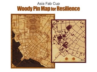
9.
OpenStreetMap can provide latest
map data to fabbers. ! OpenStreetMap ↓ QGIS ↓ Inkscape ↓ Laser Cutter
10.
OpenStreetMap can provide latest
map data to fabbers. ! OpenStreetMap ↓ QGIS ↓ Inkscape ↓ Laser Cutter (.shp) (.pdf) (.eps) http://extract.bbbike.org/
11.
WoodyPinMapforResilience
12.
Already, I’ve made
a map data for raser cutter.
13.
14.
You can use
like this…
15.
Real PushPin maps +
16.
base map for
board game + by 3D printer
17.
base map for
disaster risk management + with Cellophane paper
18.
If natural disaster
occurs, then you can use base map for relief.
19.
WoodyPinMapforResilience
20.
Thanks!
21.
President of Race
for Resilience Vice-President of OpenStreetMap Foundation Japan @mapconcierge
Download now