Ramasetu
•
3 gostaram•14,980 visualizações

Rama Setu: 315 page e-book The book presents multiple facets of the Setu Samudram Channel Project and evidences for Rama Setu as a monument of international importance.

Recomendados
Recomendados
Mais conteúdo relacionado
Mais procurados
Mais procurados (20)
Destaque
Destaque (16)
Semelhante a Ramasetu
Semelhante a Ramasetu (20)
Mais de Srinivasan Kalyanaraman
Mais de Srinivasan Kalyanaraman (20)
Último
Último (20)
Ramasetu
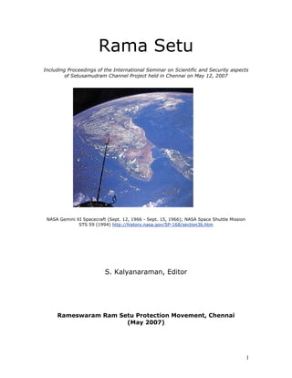
- 1. Rama Setu Including Proceedings of the International Seminar on Scientific and Security aspects of Setusamudram Channel Project held in Chennai on May 12, 2007 NASA Gemini XI Spacecraft (Sept. 12, 1966 - Sept. 15, 1966); NASA Space Shuttle Mission STS 59 (1994) http://history.nasa.gov/SP-168/section3b.htm S. Kalyanaraman, Editor Rameswaram Ram Setu Protection Movement, Chennai (May 2007) 1
- 2. Table of Contents Preface Page Rama Setu: tradition and progress with compassion Scientific-Economic Aspects Geological and Geophysical perspectives of the Ramsetu bridge Scientific evidence for ancient human activity in the project area Rama’s Bridge – A note on its origin 'Rama Setu bridge is man-made only' AR Mudaliar Committee (1956) Report against any passage across Adam’s Bridge (Rama Setu) SSCP - A monument of fraud and infamy Will ships use canal at such costs? Why the Ram Setu must not be destroyed Where Will The Next Tsunami Hit? Assessing the Stability of the Setusamundram Shipping Canal Sediment Characteristics of the M-9 Tsunami Event Between Rameswaram and Thoothukudi, Gulf of Mannar, Southeast Coast of India Save our dugongs from extinction Will the Gulf of Mannar be saved? Gulf of Mannar: the first marine biosphere of south asia Ramanathapuram District: Gulf of Mannar Marine Biosphere Reserve Coral Reefs Distribution (Gulf of Mannar) Coral Reefs of India: Review of Their Extent, Condition, Research and Management Status Crusader against the Setusamudram project speaks Prime Minister’s Office exposes system slip-up Concern on Environmental impacts Setu Channel passage: 34 Lankan experts call it eco disaster Study sought on impact of Setusamudram Socio-Cultural Aspects “Rama Sethu should not be broken” Pride in History first step to renewal Setusamudram Channel Project – Project area Seven islands between India and Srilanka Palk Strait to Gulf of Mannar -- An Archaeological Exploration 2
- 3. Rama Setu through the Ages Early coins and copper plate inscription of ca. 900 CE refers to ‘Setu’ Textual evidences for Rama Setu (or Setu bandha) Epics and classics Epigraphs Other textual references on Rama’s bridge Rama Setu in literature – a truth Rama Setu in sculptures (9th and 10th centuries CE) Arguments for Setubandha as a sacred monument U.S. court backs Indian tribe on sacred mountain Security Aspects Setusamudram Shipping Channel Project (SSCP) -- A Mariner’s Perspective Channel passage through Rama Setu (Adam’s Bridge) adversely impacts National sovereignty, integrity and safety Palk Bay Issues and Security Concerns: An Analysis Setusamudram Project: Reasons for the Construction of the Canal and its Economic & Environmental Impact on Sri Lanka An overview of world thorium resources, incentives for further exploration and forecast for thorium requirements in the near future Importance of thorium for Bharatam’s strategic program Historical background on and evaluation of Tsunami of Dec. 26, 2004 A Catalog of Tsunamis in the Indian Ocean Tsunamis on the coast lines of India Tsunamis return after 60 years Impact of Tsunami on Setusamudram Shipping Channel and the neighboring coastal areas Classification of tsunami hazard along the southern coast of India: an initiative to safeguard the coastal environment from a similar debacle Tsunami impacts on morphology of beaches along south Kerala coast, West 3
- 4. coast of India Impact of the Tsunami and the Setusamudram project How Japan handles tsunami threat Coastal action network (A comprehensive document prepared by a group of experts explaining why the environmental clearance given to the Setusamudram Channel Project should be withdrawn and the project reviewed). List of illustrations On cover NASA Gemini XI Sept. 12, 1966 showing Rama Setu linking India and Srilanka ISRO image 26 Oct. 2003 Rama Setu Preface NASA SRTS February 2000 Rama Setu International Space Station Expedition 6 Feb. 23, 2003 Rama Setu Medial line as Setu Channel Passage Islands around Rameswaram Plate tectonic situation in Indian Ocean Abbreviations BCE – Before Common Era CE – Common Era ISRO – Indian Space Research Organisation NASA – National Aeronautics and Space Administration (USA) NRSA – National Remote Sensing Agency (ISRO) SSCP – Setusamudram Channel Project 4
- 5. Preface NASA Gemini XI Spacecraft (Sept. 12, 1966 - Sept. 15, 1966); NASA Space Shuttle Mission STS 59 (1994) http://history.nasa.gov/SP-168/section3b.htm Image credits: NASA Johnson Space Center – Earth Sciences and Image Analysis, April 1966 Report of NASA http://history.nasa.gov/SP-168/section3b.htm Exploring space with a camera by NASA quot;[193] Gemini XI. This photograph from an altitude of 410 miles encompasses all of India, an area of 1250 000 square miles,quot; GEORGE M. LOW, then the Deputy Director, Manned Spacecraft Center, NASA, notes. quot;Bombay is on the west coast, directly left of the spacecraft's can-shaped antenna New Delhi is just below the horizon near the upper left. Adam's Bridge between India and Ceylon , at the right, is clearly visible. A cloudless region surrounds the entire suBCEontinent. Differences in color, green near the west coast, and brown inland, delineate regions of heavy vegetation and semiarid areas.quot; The picture by NASA is available on the NASA website. http://history.nasa.gov/SP-168/p193a.jpg Rama Setu as a land-bridge Feb. 23, 2003 International Space Station Expedition 6 (Bridge linking Dhanushkodi and Talaimannar as seen from the Space Station) 5
- 6. Rama Setu as seen on Satellite image (Google Earth, 2 May 2007) October 26, 2003, ISRO (National Remote Sensing Agency) Resource Satellite 1 http://www.isro.org/pressrelease/ph2.jpg Survey of India logo: Aasetu Himachalam, 1767 http://www.surveyofindia.gov.in/ 6
- 7. http://www2.jpl.nasa.gov/srtm/srilanka.htm Shuttle Radar Topography Mission (SRTM) of NASA aboard space shuttle Endeavour launched in February 2000. quot;Sri Lanka is shaped like a giant teardrop falling from the southern tip of the vast Indian suBCEontinent. It is separated from India by the 50km (31mi) wide Palk Strait, although there is a series of stepping-stone coral islets known as Adam's Bridge that almost form a land bridge between the two countries.quot; The book is based on the proceedings of the International Seminar on Scientific and Security Aspects of Setusamudram Channel Project (SSCP), held on May 12, 2007 at Chennai. Some articles which appeared in scientific journals have also been reproduced/ excerpted, with permission, to make the presentation comprehensive and provide for a continuity of coverage of multi-dimensional aspects which have been ignored or cursorily dealt with in the project design and implementation. The deliberations are presented in three sections: 1. Scientific-Economic Aspects; 2. Socio- Cultural Aspects; and 3. Security Aspects. Socio-Cultural aspects are included because the Environmental Impact Manual prepared under the Environmental Protection laws of the land, includes a specific requirement related to an evaluation of cultural aspects related the project area. It is surprising that the only reference in all the reports related to the project is a bland statement that there are no archaeological sites along the project alignment. This is a shocking ‘evaluation’, to say the least. SSCP is under implementation since 2 July 2005. What started as a Canal recommended by AR Mudaliar Committee (1956) has been transformed into a Channel Passage in the Indian Ocean (Hindumahasagar) constituting de facto International Waters Boundary in the Historic, internal waters between Bharatam and Srilanka. It has transpired that, deviating from the previous five alignments considered for a ‘canal’ across the Gulf of Mannar (since the first alignment proposed by AR Mudaliar Committee in 1956 across Mandapam), the character and scope of the project has been radically altered by the chosen alignment cutting a 300-metre wide, 12 m. deep passage across Ramasetu (Ramarpalam) thus attempting to create and maintain a ‘channel passage’ in the Indian Ocean. The categorical recommendations of AR Mudaliar Committee Report were as follows: [quote] We are convinced that the Adam’s Bridge site is unsuitable for the following reasons: First: The shifting Sandbanks in this area present a far more formidable problem – both at the stage of construction and during maintenance – than the sand dunes on the island site. Secondly: The approaches to a channel would be far too open with no possibility of construction of protective works. A channel at this site – even if it can be made and maintained (which is unlikely) – would entail definite navigational hazard. Thirdly: The channel would be bordering on the Setusamudram Medial Line. In these circumstances we have no doubt, whatever that the junction between the two sea should be effectd by a Canal; and the idea of cutting a passage in the sea through Adam’s Bridge should be abandoned. [quote] 7
- 8. The arbitrary, fast-track choice of alignment (which is 34 nautical miles longer than a closeby alignment) has created serious apprehensions among the people world-wide since the Ramasetu is an ancient cultural monument. The objective of the Seminar is to review and evaluate, with participation by experts, the SSCP scientific, technical and management aspects such as: imperative of incorporating tsunami protection measures as integral components of • the project impact on the livelihoods of coastal people of both Bharatam and Srilanka • marine resources and preservation of fragile biosphere and national marine parks • rationale for, pro-s and con-s of alternative alignments considered for the canal and • the implications denting the Ramasetu on bio-reserves, thorium/titanium type of heavier minerals for the nation’s nuclear programme international, maritime and geopolitical dimensions of the proposed passage through • the ocean including national security aspects related to the guarding of the sea-lanes cultural aspects associated with the project area in general, Ramasetu and associated • archaeological/cultural sites, in particular. Rama Setu had saved the coastline during tsunami; stop Setu Project Ramar bridge (RamaSetu) had saved the coastline during tsunami 2004. Breaking the bridge with a 300-meter wide channel passage in the Indian Ocean (Hindumahasagar) will suck the next, impending, tsunami directly into the Bharatam coastline. Devastation will be incalculable, particularly in the coastline of southern Bharatam including Tamilnadu and Kerala. Scientific and other evidences prove that the Rama Setu is an ancient land-bridge. This is a monument of national and international significance and should be declared as a World Heritage Monument. See: http://ramasetu.blogspot.com/2007/04/bamiyan-and-setu.html See the following from among the lists of World Heritage Sites of UNESCO: http://whc.unesco.org/en/list/1138 Coiba National Park and its Special Zone of Marine Protection in Panama http://whc.unesco.org/en/list/653 Tubbataha Reef Marine Park in the Philippines http://whc.unesco.org/en/list/898 Kvarken Archipelago / High Coast in Sweden/Finland http://whc.unesco.org/en/list/369 Giant's causeway and Causeway coast in UK http://whc.unesco.org/en/list/154 Great Barrier Reef in Australia http://whc.unesco.org/en/list/764 Belize Barrier Reef Reserve System in Belize http://whc.unesco.org/en/list/80 Mont St. Michel and its bay in France http://whc.unesco.org/en/list/672 Ha Long Bay in Vietnam http://whc.unesco.org/en/list/306 Matobo Hills in Zimbabwe Aren't there good reasons why Rama Setu (or Nala Setu) should be declared as a World Heritage Site? Is it not abhyudayam to cherish and protect ancient monuments? Could anyone support what the Taliban did to the Buddha in Bamiyan? Were the Taliban merely quarrying stone? Surely, there should be some limits to ignominy. NASA images clearly establish a land bridge between Dhanushkodi island (Rameshwaram side) and Talaimannar island (Srilanka side). This bridge is composed of a series of islands and shoals (sand accumulations created by ocean currents). Thus, the entire bridge right from the sea-bed to the surface sea level is a bridge formation which has been recognized as a land bridge linking the two regions: Bharatam and Srilanka. To what extent there was manual intervention in connecting the gaps between the shoals and islands during the pre-historic periods as detailed in the ancient texts such as Ramayanam is a matter for detailed marine archaeological and geological evaluation. The reports of submergence of Kumarikandam, 8
- 9. Poompuhar, Dwaraka along the coastline and the formation of the Gulf of Khamba about 10000 years ago (confirmed by scientists of National Institute of Ocean Technology) point to the possibility that the recent historical record of submergence of Dhanushkodi island should provide for a pause and re-evaluation of the impact of the ocean currents and changes in sea- level on the coastline and also on the SSCP. Such a multi-disciplinary archaeological- geological-aquatic environment study should be undertaken respecting the sentiments of the people who has looked upon the bridge as a land-link between Bharatam and Srilanka. The fact that India is described in Government logo as Aasetu himachala paryantam, the fact that the project itself is called Setusamudram canal project (Setu means bridge), confirms the tradition related to the bridge. Hurting the sentiments of the people who revere Sri Rama as a divinity and personification of dharma will be a serious breach of trust and utter disdain for peoples’ sentiments. In fact, the SSCP should be reconsidered and the pros-and-cons of reactivating the land bridge between Srilanka and Bharatam should be considered afresh. A bridge may be more beneficial for both countries than a canal. The canal has limited draught and will NOT provide for the movement of large-sized tankers of the carrying capacity of, say, 2 million tones of fuel oils from the Persian Gulf region. The canal may have only a limited use for very small naval vessels. The impact on coast guard to secure the sea-lanes has also to be evaluated. The most serious concern is that this is an experimental project for constructing a canal within the ocean, and will be unprecedented in the history of navigation. Should Bharatam undertake such a high risk project with questionable value to both Bharatam and Srilanka. The authorities should set up a high-level, multi-disciplinary panel including representatives from the people of the region to re-evaluate the project, remembering that the British regime chose NOT to construct this project and instead used the railways to carry bulk commodities from the coal and iron-ore belts to the coastal cities like Chennai, Mumbai and Tuticorin. Even the Tuticorin port projects will get their sulphur-free-coal imported from Australia and the canal will not carry naval vessels carrying such imports and certainly not the fuels imported from the Gulf region. SSCP channel passage seeks to cut through this bridge. The sudden choice of the medial line as the channel in preference to five alignments recommended earlier is a matter for serious concern, causing apprehensions about the disregard for due process in designing a project of this importance seeking to link west and east coasts of Bharatam through a canal ship-route. 9
- 10. Plan showing various alignments of the Setusamundram Canal and the groups of islands (marine parks) in the Gulf of Mannar (reproduced from NEERI Report, 2004). NEERI introduced a new alignment which changed the entire nature of the project. What has been considered as a canal (comparable to Suez or Panama as land-based and hence, controllable canal) since AL Mudaliar Committee Report of 1956, has been transformed by NEERI in 2004 into a passage in the mid-ocean, cutting across the Adam's Bridge. All the previous 5 alignments reviewed in detail DID NOT cut across the Adam's Bridge. NEERI has failed to take note of the serious consequences noted by Mudaliar Committee (Para 16) of any channel passage through Adam's Bridge. NEERI has failed to take note of the cultural significance of the Adam's Bridge. It is considered as Setu Teerth (clearly mentioned in the Kurma Purana) and adored in the nation's ancient tradition. Rama Setu (also called Adam's Bridge) has always been considered a bridge or causeway in ALL previous texts, in ancient texts, in epigraphs, in travelogues, in government documents since the days of the British rule. There has been NO due diligence before suggesting an alternative sixth alignment which seeks to create a passage in the mid-ocean. Environment Impact Assessment Manual (Jan. 2001) of Dept. of Forests and Environments stipulates: quot;Assessment of impact on significant historical, cultural and archaeological sites/places in the area.quot; No discussion on this topic is found in the NEERI and other reports related to the project. Respondents' (Union of India) Counter No. 11 states: 10
- 11. quot;EIA study revealed that in view of the environmental sensitivity along the coastal stretch of Gulf of Mannar harbouring the Marine National Pazrk, an alignment keeping a minimum distance of 6 to 8 kms from Van-Tiu Island in Tuticorin and more than 20 kms from Shingle Island in Adam's Bridge approach area is the most suitable. This alignment at a distance of 4 kms. From the Medial Line at Adam's Bridge and about 3 kms. at other places.quot; This statement directly runs counter to the arguments advanced in AL Mudaliar Committee (1956) report whose observations related to Adam's Bridge have been scrupulously observed by the various Committees which proposed and recommended alternative alignments, all of which DID NOT pass through the Adam's Bridge. Neither the EIA report, nor the project feasibility reports discuss why the serious objections raised by AL Mudaliar Committee Report were NOT discussed and were NOT answered. Issues highlighted in this publication, calling for an urgent review and re-evaluation of SSCP are: Issue 1 The choice of a channel alignment for Setusamudram Channel Project (SSCP) should be done only after a detailed multi-disciplinary evaluation of the impact of tsunami of the type which struck the coastline of Bharatam on Dec. 26, 2004. RamSetu in fact saved the coastline of Bharatam reducing the impact of the last tsunami. If the work is continued on the present alignment is continued, an enormous energy of the next tsunami will be absorbed through this channel and result in the destruction of Kerala and significant parts of Tamilnadu coastline. On 8 March 2005, Prime Minister’s Office raised 16 objections including the observations of the world-renowned tsunami expert, Prof. Tad S. Murthy of Canada who has been enaged as an expert by the Govt. of Inda to set up a tsunami-warning system in the country. Prof. Murthy is firmly of the opinion that this present alignment will destroy Kerala and most of the coastline of southern Bharatam. These concerns and the impact of a tsunami should be subjected to detailed, multi-disciplinary evaluation before work on a channel is resumed using any one of the other five alternative channels available (including the one recommended by GOI steering committee 1996) which will NOT involve destruction of RamaSetu. Issue 2 The creation of an artificial boundary between Srilanka and India in the Indian Ocean will adversely impact the livelihood of coastal people, particularly the fishing community, who will be prevented from crossing the channel boundary. Issue 3 There is also the issue of thorium and other rich mineral deposits close to the RamSetu in Kerala thorium sands. The entire region should be subjected to geological exploration to utilize these mineral resources which will have a profound impact on the country’s nuclear program according to the website of Bhabha Atomic Research Centre. Issue 4 Declaration of Rama Setu as a Protected Monument of national importance. The proposed channel alignment involving the destruction of Ram Setu, hurts the sentiments of millions of people who look upon Ram Setu as Setumandir, a pilgrimage site, a sacred monument, a temple. This age-old Setubandhan, this age-old temple, should be declared as a World Heritage Site, citing textual, epigraphic and scientific evidences of Dept. of Earth Sciences (March 2007) pointing to ancient human activity. We hope that the issues evidenced scientifically in this publication and the seminar deliberations, will provide a framework for further deliberations and to ensure that no damage is caused to Rama Setu. A Parliamentary Committee should be constituted to re-evaluate the project and to re-align the Canal, as a land-based canal and NOT as a mid-ocean channel passage and to ensure incorporation of adequate tsunami protection measures. We gratefully acknowledge the contributions made by the following scientists and scholars in making the conduct of the seminar and this publication possible: 11
- 12. Dr. Shikaripura Ranganatha Rao, who inaugurated the seminar, has served the Archaeological Survey of India in various capacities. Dr. Rao has led excavations of many important sites such as Rangpur, Amreli, Bhagatrav, Dwaraka, Hanur, Aihole, Kaveripattinam and others. He is the founder of the Society of Marine Archaeology in India. Dr. Badrinarayanan, who served with distinction as Geologist in Geological Survey of India was a consultant to National Institute of Ocean Technology. Captain Hariharan Balakrishnan Retired naval officer with distinguished service in the Indian Navy; is an alumni of National Defence Academy, Khadakvasala and Defence Services Staff College, Wellington; he is an anti-submarine warfare specialist from the former USSR Naval War College, St. Petersburg and has commanded various naval ships during his service including the guided missile frigate,INS Trishul. Prof. C S P Iyer, Exec. Director, Centre for Marine Analytical Reference and Standards, Regional Research Laboratory, Trivandrum; Senior Scientist, Kerala State Council for Science, Technology and Environment. S. Kalyanaraman, Ph.D., Director, Sarasvati Research Centre, Former Sr. Executive, Asian Development Bank, Author of 8 volume encyclopaedic work on Sarasvati Civilization, rediscovery and revival of River Sarasvati and involved in the promotion of National Water Grid Shri D. Kuppuramu, Advocate, Director, Pandyan Grama Bank, State Project Coordinator, Tsunami Relief and Rehabilitation Works, Seva Bharathi Tamilnadu (NGO), State President, Tamilnadu Bharathiya Meenavar Sangam, Ramanathapuram *Prof. Tad S Murthy, Ottawa. Vice-President, The Tsunami Society, Member, Editorial Board, The International Journal of the Tsunami Society, expert engaged by Govt. of India, Ministry of Science and Technology, to set up a tsunami warning system. Prof. Madhav Das Nalapat holds the UNESCO Peace Chair and is a professor of geopolitics at the Manipal Academy of Higher Education; one-time resident editor of the Times of India Justice Parvatha Rao, Retd. Judge, Andhra Pradesh High Court. Shri TV Rengarajan, South India Organizing Secretary, Akhila Bharatiya Itihasa Sankalana Yojana. Retired Principal, Junior College, Coimbatore. Scholar of Tamil and Sanskrit language traditions. Shri T. Satyamurthy, Former Director of Archaeology, Govt. of Kerala, Senior Superintendent (Retd.), Archaeological Survey of India who has served in ASI in various capacities. Shri V. Sundaram, IAS (Retd.), Associate Editor, News Today, was the first chairman of Tuticorin Port Trust. He was the one who completed the work on coal jetty, oil jetty and other facilities in connection with the commissioning of Tuticorin Harbour Project. He became its chief on 1April 1979. * Since Prof. Tad S. Murty will be in Alaska all of May participating with a team on the Pacific tsunami warning system computer modeling and is engaged in editing a manual on storm surges on the globe from tropical and extra-tropical cyclones, he has sent his good wishes for a productive and successful seminar. We gratefully acknowledge the support and encouragement provided by thousands of people, too many to be named individually and who have given us the strength to launch and carry 12
- 13. forward the Movement with the blessings of Sri Rama, who according to Valmiki, is vigrahavaan dharmah (embodiment of dharma). Rama Setu: an intersection of tradition and progress This is a historic moment in our history. This is historic because the word 'setu' evokes immediately a sacred social memory of Sri Rama, under whose command the bridge was built. This tradition is a world wide tradition, a sacred memory in particular in the Indian Ocean Rim states populated by over 2 billion people. The memory of Sri Rama is immortal and will survive this and future generations. Sri Rama was a person who was divine. Our tradition says that he is divine incarnate. The events and places associated with this social memory related to Sri Rama are indelible and are integral parts of our lives and the lives of future generations. It is our responsibility, our dharma to protect, preserve and cherish a monument associated with Sri Rama at the intersection of land and ocean, at the intersection of civilization and progress. We are in favour of the Setusamudram channel project which seeks to provide an alternative sea-lane between Tuticorin and other ports of the world. We are gathered here to deliberate on this historic project from a geopolitical perspective and a civilizational perspective. Both perspectives are intertwined in a project which has the potential to create history. In bharatiya tradition, spiritual and secular intersect. What is setubandha for one is Rama Setu for another. Brige it is, linking abhyudayam and nihs'reyas. Both abhyudayam and nihs'reyas are two sides of dharma which is sanaatana, esha dhammo sanantano. Bauddham in Lankavatara Sutra tradition notes that the Buddha walked across the bridge to reach Adam's Peak what was called Vishnupaadam. In muslim and Christian traditions, Adam after banishment from heaven reportedly walked across the bridge to reach Adam's Peak, what was called Vishnupaadam. Let us call it Rama Setu because the setu is enshrined in sculptures in Java, Indonesia in the Parambanan temple (Brahmavana). References to Dharba sayanam where sri rAmA does a saranAgathy to samudra- rAjan to grant him permisson to cross the sea. SlokA 52,53,54 *************** 52 : prathisayana bhumikA bhooshitha payOdhi puLina ! Jaya ! Jaya ! Hail to Thee O Raghuveera , who beautified the assembly of sands of the beach (at ThirupullANi ) through your lying down on them in a bed of sacred grass in observance of Your PraayOpvesam ! Hail to Thee ! **************************************************** 53: praLaya sikhi parusha visika sikhA soshitAkupAra vAripura ! Jaya ! Jaya ! 13
- 14. (Meaning ) : Hail to You , O Raghuveera , who evaporated the waters of the ocean with the power of your arrows that resembled the fire which destroys the world at the time of deluge ! ************************************************** 54 : prabhala ripu kalaha kuthuka chatula kapikula karatala toolitha Hrutha giri nikara sAdhita sethupatha seemA semanthitha samudhra ! Jaya ! Jaya ! ( meaning ) :O mighty hero of the scion of Raghus, who created the demarcation of the ocean with your bridge built by the mighty monkeys,who out of their eagerness to reach LankhA to fight their enemies splintered huge mountains and threw them into the ocean as though they were feathery bales of cotton ! Hail to Thee! Hail to Thee ! (Source: Swami Desikan's Raghu veraa Gadhyam (aka) Sri mahAveera Vaibhavam.) Periya thirumozhi of Thiru Mangai azhwar (Parakala Naayaki) 9.4.5 about dharbas'ayanam/ thirupullani a divya desam 15 kms from Rameshwaram Listen to the audio. quot;PullaaNi Emperumaan poi kettirunde_ne_.. quot; (I have only heard now of His lies..!) All my relatives come and tell me..quot;You should have listened to us. You listened to Him. We spoke truth; He has become a liar. quot;. quot;Okay. I will now listen to you all. But, only after getting my heart back that had gone behind Him.quot; says Parakala Nayaki. (vallaaLan pin pOna nenjam varumaLavum..) Though all of them talk about me, I am still trusting that quot;Great liar (of ThirupullaaNi Emperumaan's)'s words and am living with a (faint?) hope. Thirumaalai by Thondar Adi Podi Azhwar also refers to emperumaan at the Setu. This social, civilization memory is eternal and will continue to guide us as we embark on projects for abhyudayam. Abhyudayam does not have to be at the expense of cherishing sacred tradition. The bhakti movement of Azhwar like Thiru Mangai Azhwar and Thondar Adi Podi Azhwar will continue to be an inspiration for the youngest nation in the world with over 70% of the population being less than 35 years of age. Rameswaram Ram Setu Protection Movement 12, MV Street, Chetpet, Chennai 600031 Tel. 044 2836-0243, 9443034076, 9444274280 saveramasetu@gmail.com 14
- 15. 15
- 16. 16
- 17. 17
- 18. 18
- 19. 19
- 20. 20
- 21. Rama Setu: tradition and progress with compassion D. Kuppuramu Advocate, State President, Tamilnadu Bharatiya Meenavar Sangam, Ramanathapuram Ever since it was announced that Rama Setu will be destroyed to implement the Setusamudram Channel Project, strong opposition has been expressed by the Movement on behalf of Hindu organizations. In the year 2006, on Ramanavami day, a nation-wide signature campaign was launched to express peoples’ support for our pleas. Our opposition was expressed through a petition signed by 35 lakh people which was presented personally to His Excellency President Dr. Abdul Kalam. On 10 December 2006 when we learnt that dredging work is likely to begin in the Rama Setu area, myself and Pujya Swami Omkarananda Maharaj of Theni filed a civil petition in the Ramanathapuram Court on 15 December 2006 seeking injunction against the ongoing work. After attending the court session on 12 January 2007 I returned home and finished my lunch. As I came into the hall, my mother asked me: “My dear son, what happened to the Rama Setu case?” “They are claiming that Rama Setu does NOT exist,” I sat down in a chair responding to my mother. “Who says there is no Rama Setu?” thundered my mother , sitting up in her chair. The sheer majesty of her stance made me realize that Mother Paraashakti herself was asking this question and I saw Bharata Mata in my mother’s presence. “That is what the Government advocate is saying, mother, that Rama Setu does not exist; they say that there is no scientific evidence,” I responded. “Who is saying that Rama Setu or Setu Tirtha does not exist?” so saying, my mother raised up from her chair quivering with anger and standing majestically, she started speaking in a resolute tone. “The existence of Rama Setu is real. The existence of Rama Tirtham is real. You are the living testimony to this. Your very birth is the evidence,” she said. She continued: “After my marriage, two children were still born. I did not have a child for 10 years. People said that I will not have a child. Later, our elders told me that I should go to Dhanushkodi for teerthastnaana and perform puja, ‘you will have a child’ they said. I told this to my close friend. Myself and your father went with my friend to Dhanushkodi on a teerthayaatra and made a sankalpam at the Rama Setu. Within a year after we performed this teerthasnaanam you were born as my son. This is why, you are the evidence for the reality of Rama Setu and Setu Teertham. I will say this to anyone. I will depose before any court. Take me to your court, I will tell the judges there” so saying in a magisterial voice, she stood in front of me. 21
- 22. My mother who had appeared to me like Mother Paraashakti and as Mother Bharata Maata now appeared to me in the form of fierce Bhadrakaali in rudrataandavam. I folded both my hands, stood up in reverence. “When is the next hearing? I am coming the court,” she asserted. “Next month on 2 February 2007”, I said. “Remind me. I will come to the court”, she said again. Without my reminding her, she was ready to come to the court on 2 February 2007. She came to the court. Even though there was no provision in the court proceedings to cross-examine her, I took her with me to the court to satisfy her intense yearning. She expressed her anguish at the behavior of some people denying the existence of Rama Setu and shared that anguish with my colleage advocates and friends assembled in front of the court. This incident affected me intensely. All mothers of our nation have feelings similar to the feelings of my mother. If this information reaches them, they will find a solution to the issue. It is amazing indeed that Rama Bhakti, Rama Setu, Rama Teertham, are so deeply founded in our society. Maybe, we may not know the names of our ancestors of the previous four or five past generations. When this is the situation, mothers remember Rama who lived many yugas before our times and narrate to their children the events of his life and the places related to his life. The society has transmitted this from generation to generation. Because it is satyam, it is standing firm even today. What foolishness it is to search for scientific evidences for such a Rama, such a Rama Setu, such a Rama Teertha? The presiding judge of the Ramanathapuram Sub-court, Hon’ble Judge A. Muhammad Abtaqir said in his judgement: “Ancient monuments should be protected.” The issue is subjudice. As we enquire further, we find that fisherfolk who venture in to the ocean to collect algae (kadal paasi), take extraordinary caution and care to ensure that no portion of the Rama Setu is broken. If by mistake, any damage is caused to any rock on the Rama Setu, they consider it a divine error and fear that something untoward may happen in their family. This care, compassion and caution is observed by all fisherfolk irrespective of their religious affiliations. People of all faiths exercise this caution and care. Fisherfolk who live in poverty, about 3500 of them, including 2000 fisherwomen, are engaged in the tasks of collecting algae. In a year about 75,300 tonnes of algae are collected. There are 147 varieties of algae and aquatic flora here. The earth of Rameswaram is considered sacred because Rama installed the Sivalinga made of the earth of Rameswaram, which was worshipped by Sita. Beyond religious concerns, the earth is looked upon with reverence. Even today, there is no cultivation of the soil using a tractor or a plough. People tend and ready their farms using only shovels. The politicians of Tamilnadu are no exception to such practices. They do not retain their flamboyant, grandiose politics in the island of Rameswaram. If politicians come to the earth of Rameswaram thinking arrogantly that they are superior people, they lose their political offices. They are convinced that they will lose their political power, the regime collapses, elections are lost, personal lives are impaired. Politicians do accept the traditions of the people who note that in Rameswaran, the Isvara of Rama 22
- 23. is supreme. Rama who worshipped this supreme divinity is supreme. Those who have scoffed at these traditions have been destroyed. There are many evidences for this. “Those who consider the earth of Rameswaram as sacred live and flourish in the world. Those who trod on the earth with disdain and arrogance have fallen.” In a spiritual quest, Setubandha Rameswaram is as sacred as the Gulf of Mannar and Palk Bay are the world’s serene and pure waters of the ocean. This is why, there are unique species of s’ankha (turbinella pyrum). There are about 3600 rare aquatic species in this marine biosphere. Recognizing this, the region was declared as the Marine Biosphere Reserve of South and Southeast Asia with protected National Marine Parks, spending several hundreds of crores of rupees to conserve the heritage. The Gulf of Mannar Protected Marine Biosphere is 10,500 sq. kms. in extent. Out of this, 560 sq.kms. of the ocean is declared as a National Park. This National Park is an aquatically rich region, on 21 small Coral reef islands between Rameswaram and Tuttukkudi (Tuticorin). Along the coastline, there are 125 fisherfolk villages. The population is 1,60,000 and there are about 9000 fishing boats. This conservation and protection is to protect the coral reefs and aquatic resources for economic exploitation, with ecological conservation and to provide livelihood to the coastal people. Is it not a wonder of wonders that such a government which isspending several crores of rupees for conserving the ecology of the fragile ecozone, should now be spending several thousand crores of rupees to destroy and demolish Rama Setu, this gigantic coral reef, despite scientific evidences for human activity on both sides of the reef, without safeguarding the coastline, protecting the livelihood of fisherfolk, without respecting the traditions and sentiments of people closely intertwined with their culture? What type of justice is this? How can this be accepted? The Palk Straits and Gulf of Mannar are the breeding grounds of aquatic resources. It is through this region, the aquatic wealth of Bay of Bengal and of Indian Ocean are generated. These resources include the ‘Oil sardine’ which yield significant income to the fisherfolk. Because of this, the fisherfolk of northern portions of Tamilnadu coast, and of Andhra coast benefit. What will happen to this aquatic wealth if Rama Setu is desiccated? What will be the fate of the lives of fisherfolk and coastal people of Tamilnadu, Andhra and Orissa? Without detailed multi-disciplinary evaluation of the impact of the December 2004 tsunami which impacted north Tamilnadu, Kanyakumari and Kerala coastal villages, the impact on mineral resources and resultant changes in the economic and social conditions of the coastal people, the hazards posed by the Setusamudram Project and carrying on with the project by claims are sought to be made that the project is continued because it was designed by the previous government. Claims are also made that the project is continued because it is a 150-year old project. It has to be completed by 2008 and hence the work is progressing. So saying, without systematic enquiry and investigation, working in haste, will the progress lead to uncertainties in the lives of coastal people of Kerala and Tamilnadu? 23
- 24. Why is the Dhanushkodi Setu teertha sacred? Sri Rama reportedly installed three s’ivalinga in this teertha. From a scientific, oceanographic perspective, there is an ocean stream circulating the earth which has accumulated life-force and attains its purest state in this place where a confluence of three ocean currents occurs. At the brahma muhurta, say between 4 and 6 AM, the waters are considered sacred and most beneficial to the aquatic living organisms. Given the close proximity to the algae (photoplyktons), these waters have the sacredness attributed to them as life-giving waters and hence, the tradition among mothers desirous of children performing teertha snaana puja at this tirtha. At this teertha when sankalpam and tarpanam is performed for ancestors and pitr-s, they are remembered and invoked to bless the present and future generations. We are all children of our forefathers and our socio-cultural history is bound to the tradition that our ancestors have bequeathed to us. 24
- 25. 25
- 26. 26
- 27. 27
- 28. 28
- 29. 29
- 30. 30
- 31. 31
- 32. Scientific-Economic Aspects Geological and Geophysical Perspective of the Ramsetu Bridge S.Badrinarayanan Director (Retd), Geological Survey of India, Formerly, coordinator, Survey Division, National Institute of Ocean Technology, Ministry of Earth Science, Pallikkaranai, Chennai. Preamble There has been lot of interesting debate on the Ramsethu Bridge said to be connecting south-eastern part of India with Sri Lanka. Most of the arguments are based on assumptions and partial data obtained from NASA satellite images. No doubt these images are astounding as they bring out the marine geomorphology of the area. But as stated by NASA official themselves “Remote sensing images from orbit cannot provide direct information about the origin or age of a chain of island and cannot determine whether humans were involved in producing any of the patterns seen”. However several other images including close range aerial photographs, bathymetric charts etc were examined. The observations given below are based purely on hard field work including geological and geophysical surveys coupled with logging and interpretations of several cores and boreholes carried out in the area. Introduction In order to understand the subject a little amount of geological information is essential. The earth has not always been very warm or cold. There have been periods of extreme cold climate that occurred in the geological past wherein most of the surface of the earth was covered with vast quantities of ice and these periods are referred to as ICE AGES. The recent one occurred during the late Pleistocene age eighteen thousand years before present. During this period the sea level was lowered by about 130m than what is today. Due to this the land area was extending far greater distances than what is today. The Indian subcontinent was extending far beyond Sri Lanka. Subsequently due to global warming and other causes there have been periodic rises in sea level submerging several of these additional areas. About 7300 BP there was a major spurt in sea level rise which resulted in submergence of several areas all over the world. Geology of the area The Indian side of the land mass adjoining the Ramsethu originates from the south- eastern end of the Rameswaram Island. The island itself is a long linear sandy terrain providing calcareous sand stone and occasional coral formation. This area was devastated by a major cyclone in 1956 when part of the area was lost to the sea. The Rameswaram Island connects the main land through the Pamban area. Further to the west charnocites and granites are exposed. 32
- 33. In order to understand the geology and the structure of the area in the marine domain several surveys were carried out onboard a research vessel with underwater sensor. These included multibeam echo sounder survey, sub bottom profiler survey, side scan sonar and magnetic survey. The entire area was sampled by deploying vibro core, mainly to the north of the Adams Bridge (Ramsethu). These surveys generally required at least 4m of water surface so that the equipments are not damaged. The bathymetric survey brought out the fact that the Adams bridge, with a shallow ridge varying in width from 1.6 to 4km. This part of the area could not be surveyed due to these factors. However it was seen from the geological and geophysical surveys that the Adams Bridge is a fault zone rising suddenly from the Bay of Bengal side to the north. This scarp like feature is the shallowest part of the Adams Bridge. Even though it is mostly submerged in water there are series of Small Island like features which project above the sea surface. In all about 10 boreholes have been drilled along this ridge up to the international boundary. Out of the ten boreholes six boreholes were in the sea. The result of the bore logging clearly showed about 1.5m to 4m marine sand followed by 1.5 to 2.5m of boulders of calcareous sand stones and coral followed again by marine sand to various depths end at continuous compact formation. It is a well known fact that the coral reefs can only form in clean and unpolluted water and these being marine organisms required firm and compact formation as foundation. The presence of loose marine sand below these clearly indicates that these are not natural and are transported. Unless somebody has transported and dumped them these could not have come there. Some of the boulders are so light they could float on water. Apparently whoever has done it has identified it as light and strong boulders to make it easy for transportation. Since the boulders are strong they can withstand lot of weight. There are corals that are present on land in Rameswaram, Pamban and Tuticorin areas. A study of them and dating them clearly show that the age of the coral is about 7300 years and the sea level at the time was 4m above the present day sea level. Then there has been a lowering of sea level and between 4 to 5 thousand years BP the sea level was about 1.5m above present day sea level. The 1.5 to 2.5m thick zone of corals and rock presently occurring at shallow depths in the sea atop the crustal portion of the Adams Bridge appeared to be an ancient causeway. The ancients appeared to have taken advantage of the crustal portion of the ridge to avoid dumping of lot of volume of rocks and boulders and also utilized less dense but compact rocks and boulders so that these could be carried easily to greater distances and at the same time strong enough to withstand pressure from above both by human as well as sea forces. The Adams Bridge is a wonderful divide separating the turbulent Bay of Bengal in the north and the calm and tranquil waters of Gulf of Mannar to the south. Due to the tranquil condition very rare species of corals and other sea organisms grew in the Gulf of Mannar, whereas the species are completely absent in the Bay of Bengal side. The turbulent tide and the associated sediments caused by the severe cyclone that occur every year in the Bay of Bengal are prevented by the ridge of the Adams bridge and there by protect the delicate conditions in the Gulf of Mannar. The dredging and opening of the Adams Bridge in all likelihood may cause the sediments and turbulent tide to enter the tranquil Gulf of Mannar and choke and 33
- 34. destroy the delicate coral island. As an alternative dredging in the Pamban or nearby areas and bypassing the Adams bridge could be favourably considered like other inter sea canal (Panama Canal) locks could be provided both in the palk bay side and Gulf of Mannar side so that such calamities could be prevented. Acknowledgement The author thanks D. Venkata Rao, Project Director and B.Sasisekaran, Scientist ‘D’ of National Institute of Ocean Technology for the help extended in the preparation of the paper and power point presentation. Illustration: Proposed Navigational Channel Alignment – Sethu Samudram Project- Drilled Borehole Locations. 34
- 35. Scientific evidence for ancient human activity in the project area Scientific evidences point to human activity in ancient times on both sides of Ramsetu as found by Dept. of Earth Sciences and ocean technologists of Bharatam. This area should be declared a protected monument under the Protection of Monuments Act and declared as a World Heritage site by the Govt. of India and advised to UNESCO… [quote]… During the glacial Maxima, the sea level was about 130 m lower than what is today. This is evidenced both on the east and west coast of India, where submerged Corals occur around 1 to 2m water depths and they are clear indicators of near coastal zone… However, during the last ice age (18,000 year BP) the entire area from India to Sri Lanka and further south and southeast were contagious land due to the highly lowered sea level. As and when there were major melting of glaciers both from the mountains as well as from the Antarctic area, the sea level was rising. These features were well recorded and studied by several submerged Coral formations all over the world. About 7,300 years BP the sea level in the southern part of India was about 3.5 m above the present level. This has been deciphered by Dr.P.K.Banerjee, who studied Corals that found in the land part as of Pamban, Rameswaram, and Tuticorin etc. Subsequently the sea level went down and rose +2m above than what is today between 5000 to 4000 years B.P. .. In almost of all the boreholes between 4.5 and 7.5m the borehole intersected hard formations, which have been found to be calcareous sand stones and corals. It is to be pointed out here that Corals are comparatively less dense, compact and somewhat easy to carry. The Corals normally grow atop compact to hard formations for the purpose of stability, and as the sea level rises, the Coral colony grows up vertically to maintain water depth of 1 to 2 m, which is essential for their survival. It is always observed that these Corals have continuous vertical growth like Lakshadweep, Andaman's, and Gulf Of Mannar Natural Park. These have always been found to grow on hard rock bottom. In the case of Adams bridge area we observe that the Coral formations hardly occur 1 to 2.5m in length and resting on loose marine sands. Most of these coral rock pieces are seem to be rounded pebbles of corals. These things appear to point these coral rock pieces and pebbles have been transported and placed in these 35
- 36. areas. Since the calcareous sand stones and Corals are less dense than normal hard rock and quite compact, probably these were used by the ancients to form a connecting link to Sri Lanka, on the higher elevations of the Adams bridge ridge and this is analogous to modern day causeway. In support of these observations there are many archaeological and geoarchaeological evidences on the south east coast of India around Rameswaram, Tuticorin and the western coast of Sri Lanka. There are raised Teri formations that supported a rich assemblage of mesolithic – microlithic tools indicating the presence of strong human habitation and activity in these areas as early as 8000 to 9000 years B.P and as recent as 4000 years B.P. On Sri Lanka side there are indications of human habitation extending to late Pleistocene (about 13,000 B.P) based on bone and fossils of human and animal form. All these point to a flourishing human activity on both side of Adams Bridge and probably when the sea levels were just right the link between India and Sri Lanka could have been established. [unquote] Source: Dept. of Earth Sciences, Govt. of India (March 2007) http://hinduthought.googlepages.com/ 36
- 37. Rama’s Bridge – A note on its origin Srinivasan V, consultant Geologist (April 2007) The origin of Rama’s Bridge, which exists between Dhanushkodi in Tamil Nadu and Talaimannar in Sri Lanka and which has later been renamed as Adam’s Bridge by the British is examined geologically to find out whether it is a geological feature or whether it is a man-made one. A submarine linear ridge originates either by the coalescence of volcanic islands appeared as a chain one by one regularly over a moving plate when it reaches a hot spot like that of Hawaii or in the form of a ridge parallel to the coast as in the case of Mid-Atlantic ridge. These two cases represent volcanic phenomena in a permanent volcanic environment. But there is no volcanic activity either in the land area or in the ocean region of Tamil Nadu because it forms part of the South Indian (Peninsular) shield which is considered to be geologically old and stable. Therefore, in the Bay of Bengal, between Tamil Nadu and Sri Lanka, there is no volcanic activity so as to give rise to a submarine volcanic ridge like those mentioned above in the location of the said bridge. A submarine linear platform or a linear plateau can form a horst, which is a linear block of rock-mass that rises up between two parallel faults or crustal fractures. Such structures and landforms are found only in the land area of Tamil Nadu (in the East-West Salem-Attur belt and in the basement rocks of Cauvery basin). But such structures and landforms are not found in its ocean region of Bay of Bengal in general and in the location of the said bridge in particular. Further coral islands formed in a chain can also produce a submarine ridge by the accumulation of the dead coral polybs. But in the Rameswaram and Tuticorin regions of Bay of Bengal, there are coral islands, but scattered in the coastal and offshore areas, and not in the said bridge area which is transverse to the coastline. Similar to the submergence of Kumari (cape Commorin) hills in the Indian ocean, no such submergence of a hill to form the said bridge is observed. The possibility of this bridge being a submarine anticlinal ridge is also ruled out because the bridge area is located in the recent sediments, which are not yet subjected to any folding activity. Hence this submarine feature, called Rama’s Bridge, cannot be included among the geological features described so far; and thus it remains to be man-made to connect the two landmasses of Tamil Nadu (India) and Sri Lanka, both being separated by the sea. That is, it would have been developed manually to cross the ocean when the sea level was lower than the present one. Such a situation during Sri Rama’s visit to Sri Lanka existed, because before he left for Sri Lanka, he worshipped Siva in the form of Sivalinga made of beach sand at the place of Rameswaram Temple. So the shoreline at that time was at Dhanushkodi from where his bridge starts. This lower sea-level continued even during later Cholas’ regime, because their capital city, Poompuhar, which was on the sea shore is now in the sea. 37
- 38. Thus Rama’s Bridge is only a man-made feature between Dhanushkodi in Tamil Nadu and Talaimannar in Sri Lanka. 38
- 39. 'Rama Setu bridge is man-made only' An interview with Swami Dayananda Saraswati NT Bureau Chennai, Apr 29: Refuting the claim of a scientist that there is no-man made structure called Rama Setu or Adam's bridge between Mandapam at Rameswaram and Thalaimannar in Sri Lanka, Swami Dayananda Saraswati (who is a scholar in such matters) has cited the study of a geologist to reaffirm his position that a bridge had indeed been built by humanity at the present site. Stating there cannot be a natural, geological formation at the Rama Setu connecting Indian sub-continent with Lanka, the spiritual leader quoting from the observations of the geologist says the climate and soil conditions in the Bay of Bengal between the two land masses did not allow for an undersea volcanic ridge (a long raised strip) as there was no seismic activity in this area. 'Nor can it be a submarine linear platform or plateau from a linear block of rock mass that rises up between two parallel faults or crustal fractures because such structures are not found in this area,' he reasoned. Refuting the claim of a scientist that there is no-man made structure called Rama Setu or Adam's bridge between Mandapam at Rameswaram and Thalaimannar in Sri Lanka, Swami Dayananda Saraswati (who is a scholar in such matters) has cited the study of a geologist to reaffirm his position that a bridge had indeed been built by humanity at the present site. Stating there cannot be a natural, geological formation at the Rama Setu connecting Indian sub-continent with Lanka, the spiritual leader quoting from the observations of the geologist says the climate and soil conditions in the Bay of Bengal between the two land masses did not allow for an undersea volcanic ridge (a long raised strip) as there was no seismic activity in this area. 'Nor can it be a submarine linear platform or plateau from a linear block of rock mass that rises up between two parallel faults or crustal fractures because such structures are not found in this area,' he reasoned. Extending the thesis further, the Swamiji said the present formation could not be a coral ridge as coral islands were scattered in the coastal and offshore areas and not in the present site which was running at right angles to the coastline. Also, the undersea land strip could not be a submerged hill or an anticlinal (sloping downward away from a common crest) ridge as the bridge was found in sediments which were not subjected to any folding activity, he explained. 'Thus with no evidence to the contrary, the under-sea bridge could not be a geological formation and remained a man-made structure only,' he said citing the geologist's study. Referring to the gazette published in 1803 by the British government for the Madras Presidency, Swami Dayananda Saraswati said in the glossary, the first entry was 'Adam's Bridge' which, it noted, was also called Rama's Bridge or Neela's Bridge. 39
- 40. The gazette also mentioned the bridge's position in terms of latitude and longitude with its dimension of 30 miles length and 1.25 miles wide. 'The gazette further reports the bridge was used by people to cross between Tamilnadu and Sri Lanka until the middle of 15th Century when there was a breach due to a storm, causing a part of the bridge to be submerged,' he recalled. The copy of the map of the bridge along with its submerged portion in that period was available in the Saraswati Mahal Library in Thanjavur. 'With all these facts, we can safely assume that Rama Setu is much more than a Hindu sentimental issue. It is an issue of national and human heritage,' the Swamiji said. If UNESCO came to know of this ancient land-strip, it would safeguard Rama Setu as a 'phenomenal accomplishment of human genius,' he said. http://newstodaynet.com/29apr/ld4.htm 40
- 41. AR Mudaliar Committee (1956) Report against any passage across Adam’s Bridge (Rama Setu) Excerpts below provide an overview of the alternative channel alignments considered to either create a canal or just a passage across the Gulf of Mannar and Palk Straits. The categorical recommendations of AR Mudaliar Committee (1956) are as follows, against any passage across the Adam's Bridge. We are convinced that the Adam's Bridge site is unsuitable for the following reasons: First: The shifting Sandbanks in this area present a far more formidable problem – both at the stage of construction and during maintenance – than the sand dunes on the island site. Secondly: The approaches to a channel would be far too open with no possibility of construction of protective works. A channel at this site – even if it can be made and maintained (which is unlikely) – would entail definite navigational hazard. Thirdly: The channel would be bordering on the Setusamudram Medial Line. In these circumstances we have no doubt, whatever that the junction between the two sea should be effectd by a Canal; and the idea of cutting a passage in the sea through Adam's Bridge should be abandoned. By not heeding these warnings, what started as a canal project has been converted into a mid-ocean channel passage. It is surprising that these recommendations have been suddenly abandoned in favour of a mid-ocean passage increasing the distance of the channel for ships, increased dredging quantities with related increased costs and exposing the entire coastline of Tamilnadu and Kerala to devastation in a tsunami of the type that struck on Dec. 26, 2004. In fact, all the alignments considered so far should be revisited and reevaluated taking into account the impact on sea-depths caused by this tsunami. The failure to consider Mudaliar Committee injunctions against any Adam's Bridge alignment and the failure to consider the impact of a tsunami on the alternative channels and the failure to provide tsunami protection measures as an integral and vital component of the project raise matters of serious concern to coastline security and security of the coastal people. Present Channel Alignment The present Setusamudram Ship Channel is locating at a distance of more than 20 Km from Shingle Island of Gulf of Mannar near Dhanuskodi. The channel connecting Gulf of Mannar and Bay of Bengal through Adam’s Bridge, Palk bay and Palk Strait running parallel to the Indo-Srilankan Medial Line at a minimum distance of 3Km within India’s own territorial waters. The total length of the channel is 167 Km, 12m deep and 300m wide at bottom. 41
- 42. The present channel having two legs one in the Adam’s Bridge where the average depth is only about 3 meters and the other leg is in the Palk Strait where the average depth is about 6m to 8m. In Gulf of Mannar and the other stretches at Palk Bay, the channel will utilize the natural depth already available. The length of the channel in various section is as under:- Section Length in KM Area G-A 04.37 Adam’s Bridge A-B 17.30 Adam’s Bridge B-C 13.38 Adam’s Bridge C-D 37.44 Palk Bay D-E 40.48 Palk Bay E-E4 54.25 Palk Strait 167.22 For further details visit http://Setusamudram.gov.in/ After the NEERI suggestion of alignment 6 (the present alignment on which work is proceeding), a cataclysmic event occurred, the tsunami of Dec. 26, 2004. This event should have necessitated a TOTAL and COMPREHENSIVE review of the entire project since the bathymetry (sea-depths) had changed (with rise of the sea-bed by about 200 metres in some regions) and devastation of aquatic life by denuding the resources in the Gulf of Mannar by as much as 66 percent. As observed in PMO observations of 8 March 2005, the impact of any future tsunami on the chosen channel passage should have been subjected to a careful, multi-disciplinary review and evaluation. This was not done. PMO observations also referred to the views of tsunami-expert, Prof. Tad S Murthy who opined that the chosen alignment with the mouth of the channel directed to the direction of the tsunami would result in the destruction of Kerala and of Tamilnadu coastline due to 1. experience of the tsunami of 1964 in Alberni canal and 2. the principle of quarter wave resonance amplification (when a body of water forcefully tries to enter a tube, the wave amplitude increases four-fold). This is what happened in Alberni canal resulting in the devastation of Alberni port. NEERI did not take into account the role of Rama Setu (Adam's bridge) and ocean currents in the accumulation of placer deposits of thorium, a vital nuclear resource of the nation. The impact of another tsunami on these resources have also not been taken into account since the new passage is likely to function like a funnel absorbing the energy of the tsunami (instead of the waves going around Srilanka) and thus, directly impacting the coastline. Rama Setu (Adam's bridge) is a sacred monument. NEERI has failed to take this fact into account before suggesting the new channel passage route. An unusual (coincidence?) event occurred on 23 June 2005 following the visit of US naval ships in 1993, 1994 and 1999 in the region to assert the US failure to recognize the traditional claims of India and Srilanka treating these as HISTORIC waters under the Law of the Sea 1958. 42
- 43. By choosing a channel passage running close to the medial line, a new phenomenon is sought to be created: an international waters boundary between India and Srilanka. A medial line is only relevant for recognizing the ownership of ocean properties of shanka (chank) and pearl fisheries. Traditionally, fishermen and pearl- divers had the freedom to move across the medial line treating the waters as historic, internal waters. US Navy Operational Directive of 23 June 2005 treating these as international waters is a serious assault on the nation's sovereignty and integrity. NEERI did not take into account the implications of the intrusion of international politics in this region. The impact on the lives of fisherfolk and coastal people will be devastating if the new new channel passage becomes a de facto international waters boundary since fish resources are available on the Srilanka side and will become inaccessible to the coastal people of Bharatam. Sea levels change; and were 130 Dhanushkodi-Thalaimannar Strait m lower about 18,000 years ago, Sea Level Change with Time that is, the Setu would have been 20 used to link Dhanushkodi and 3.5 2 0 0 Talaimannar 18000 years 7300 years Before 4000 years Before Today -20 Before -40 Meters -60 -80 -100 -120 -140 -130 Status: 12 April 2007: About 1.4 % dredging done in the Rama Setu area (35.05 kms.) Current Sea Level ~3.5 m ~ 12 m Rama Setu – shoal remains ~300 m hole All the feasibility studies and evaluations done prior during and prior to 2004 in formulating the SSCP have to be reviewed afresh because of a devastating natural catastrophe which struck the Bharatam coastline on December 26, 2004. The tsunami of December 26, 2004 had changed the bathymetry so radically that at some places, the seabed had risen by about 200 metres. It is surprising that little attention was paid to the impact of the tsunami on the project components and the imperative of incorporating tsunami protection measures was totally ignored. This is shocking dereliction of responsibility of the state: (1) to ensure national integrity and security and (2) to protect the lives of coastal people from a natural hazard of tsunami which is likely to recur since it is premised on earthquakes caused by recurrent plate tectonics. It is notable that in early April (April 2, 2007), a tsunami warning was issued to Tuticorin when a massive earthquake struck in Solomon 43
- 44. Islands. [quote] Quake lifts Solomons island out of the sea: The seismic jolt that unleashed the deadly Solomons tsunami this week lifted an entire island metres out of the sea, destroying some of the world's most pristine coral reefs. In an instant, the grinding of the Earth's tectonic plates in the 8.0 magnitude earthquake last Monday forced the island of Ranongga up three metres. Submerged reefs that once attracted scuba divers from around the globe lie exposed and dying after the quake raised the mountainous landmass, which is 32km long and eight kilometres wide. Corals that used to form an underwater wonderland of iridescent blues, greens and reds now bleach under the sun, transforming into a barren moonscape surrounding the island. The stench of rotting fish and other marine life stranded on the reefs when the seas receded is overwhelming and the once vibrant coral is dry and crunches underfoot. Dazed villagers stand on the shoreline, still coming to terms with the cataclysmic shift that changed the geography of their island forever, pushing the shoreline out to sea by up to 70 metres. [unquote] http://www.theage.com.au/news/world/quake- lifts-solomons-island-out-of-the-sea/2007/04/08/1175970944155.html http://www.bgr.de/b322/grafik/ginco_fig1_k.png Tsunami alert on coast Staff Reporter (The Hindu, April 3, 2007) Tuticorin: The district administration sounded an alert this morning along the coastline here following a tsunami strike due to an earthquake of 8.1 magnitude at Solomon Islands in the South Pacific on Monday. Collector R. Palaniyandi said that instructions were issued to people living close to the coastline to be cautious. http://www.thehindu.com/2007/04/03/stories/2007040308260600.htm Tsunami computer simulation (powerpoint show) http://sarasvati95.googlepages.com/tsunami.pps Because shoaling effects are what make the Tsunamis extreme, detailed information of the coastline is essential… 44
- 45. The same gif image is available in video format at http://www.dhisoftware.com/general/News/Tsunami/latest/AroundSriLanka_hd01A2 _DivX.avi (Can be played using Windows Media Player). Details are provided in a technical paper presented in an international symposium. http://www.dhisoftware.com/mike21/download/Papers_Docs/TsunamiPaper_v5.pdf http://www.dhisoftware.com/general/News/Tsunami/index.htm Frame from a computer animation of the December 26, 2004, Indian Ocean tsunami (animation can be viewed at URL http://staff.aist.go.jp/kenji.satake/animation.gif ). Frame shows the tsunami 10 minutes after it was triggered by the earthquake. Red represents a positive wave (crest arrives first), and blue represents a negative wave (trough arrives first—drawdown warns of approaching crest of tsunami wave). Deeper colors represent larger wave heights. (Note: This model shows a longer wave front than the oblique-perspective model, because the modeler assumed a longer fault rupture as the tsunami trigger. Seismologists are still sifting through the evidence to determine the length of the deep rupture that caused the earthquake and subsequent tsunami.) Post-Tsunami Field Surveys By December 31, 2004, six international teams (including Japanese and American teams) had been formed to document the magnitude and effects of the tsunami before the evidence is destroyed. Typically, such teams arrive in the affected areas about one to three weeks after the tsunami occurs. Because this was the largest 45
- 46. tsunami in more than 40 years and the area affected is very large, there could be as many as a dozen international teams investigating the tsunami. USGS oceanographer Bruce Jaffe and USGS geologist Bob Morton traveled to Sri Lanka from January 7 to 16 with an international team funded by the National Science Foundation and the USGS to examine inundation areas, estimate wave heights, determine the tsunami's precise arrival time, scour the area for geologic evidence and sedimentary deposits, and examine structural damage. As of this writing, the USGS had also been invited to have scientists participate in post-tsunami surveys in India, Thailand, and Sumatra. Ideally, post-tsunami surveys will include both a quick response focusing on ephemeral evidence and a later response (possibly in February or March) focusing on tsunami sedimentation and erosion. The quick response will include measurements of water levels, inundation distances (horizontal distance from the shoreline to the farthest inland reach of the tsunami), and indicators of the tsunami's flow direction and flow velocity. The later response will focus on the sediment deposited by the tsunami: whether it has characteristics that reflect those of the tsunami itself, such as its height, power, and extent; how much of the sediment is likely to be preserved in the geologic record; and how much is likely to be eroded away. The more we learn about sedimentary deposits from modern tsunamis, the more accurately we can identify and decipher sedimentary deposits from ancient tsunamis. Because scientists cannot yet predict when a tsunami will occur, learning to read a geologic record of past tsunamis may be one of the only ways to assess future risk. USGS scientists have conducted such studies of sediment deposited by recent tsunamis in Papua New Guinea (tsunami of 1998, see Preliminary Analysis of Sedimentary Deposits from the 1998 PNG Tsunami) and Peru (tsunami of 2001, see Preliminary Analysis of Sedimentary Deposits from the June 23, 2001 Peru Tsunami ). They are working to determine how sediment layers deposited by tsunamis differ from those deposited by large storms, such as hurricanes, to aid identification of tsunami deposits in the geologic record (see Sound Waves article quot;Group Aims to Distinguish Tsunami Deposits from Large-Storm Deposits in the Geologic Recordquot;). Tsunami Information on the Web Many Web sites have information about the Indian Ocean tsunami and tsunamis in general. Here are a few particularly useful ones: USGS Northern Sumatra Earthquake event page: • http://earthquake.usgs.gov/eqcenter/eqinthenews/2004/usslav/ USGS site, with basic tsunami information: • http://walrus.wr.usgs.gov/tsunami/basics.html Pacific Marine Environmental Lab (PMEL): • http://www.pmel.noaa.gov/tsunami/home.html Russian Tsunami Laboratory: http://tsun.sscc.ru/tsulab/20041226.htm • UNESCO site, with animation and links to additional news stories: • http://ioc.unesco.org/itsu/ International Research Institute for Climate Prediction site, with scientific • background on the Indian Ocean earthquake and tsunami: http://iri.columbia.edu/~lareef/tsunami/ USGS Circular 1187, quot;Surviving a Tsunami—Lessons from Chile, Hawaii, and • Japanquot; (also available in Spanish): http://pubs.usgs.gov/circ/c1187/ 46
- 47. USGS site addressing the question quot;Can it happen here in the United • States?quot;: http://earthquake.usgs.gov/eqcenter/eqinthenews/2004/usslav/canit.html (summarized in article quot;Could It Happen Here?,quot; this issue) The sixteen detailed queries raised by PMO (Prime Minister’s Office) on 8 March 2005 and the observations provided (30 June 2005, that is the date the information was posted on the government website) by Tuticorin Port Trust) are cited at the following URL in the official website of Setusamudram Corporation: http://Setusamudram.gov.in/Prime.asp Prof. Tad S. Murthy of Canada raised serious concerns on the devastation of Kerala through the proposed canal which will suck in the next tsunami waves if the present alignment is retained. The responses, again provided by Tuticorin Port Trust can be seen at URL http://Setusamudram.gov.in/TedArticle.asp See also: http://manisanga.blogspot.com/ This note deals with the following issues: 1. Questions raised by Prime Minister’s Office 2. Questions raised by Tamilnadu Pollution Control Board 3. Questions raised by tsunami expert Prof Tad S Murthy 4. Questions related to impact on aquatic environment of Gulf of Mannar 5. Questions related to social impact on livelihoods of coastal people (not covered by impact analyses) 6. Impact on sentiments of the people based on tradition of Ramar bridge 1. Questions raised by Prime Minister’s Office The timing of the response by Tuticorin Port Trust is significant. After two days, the SSCP (Setusamudram Canal Project) was inaugurated at Madurai. There is no indication if NEERI was asked to review its 2004 environmental impact analysis. There is also no indication if NEERI was asked to respond to PMO’s observations of 8 March 2005. It is strange that Tuticorin Port Trust was asked to respond to PMO’s queries. The correct agency should have been NEERI under the agreement entered into between Govt. of India and NEERI. See the terms of agreement with NEERI at http://Setusamudram.gov.in/Terms.asp The answers of the Tuticorin Port Trust which formed the basis for inaugurating the project on July 2, 2005 are apparently prepared by a private company, Dr. P. Chandramohan of Indomer Hydraulics Pvt.Ltd., Chennai. The possible conflict of interests in engaging a potential contractor/consultant in making such an evaluation is a matter of concern impacting on the impartiality and objectivity of the answers provided. On such a serious concern raised by PMO, the evaluation of the impact of a tsunami on the canal project has been irresponsibly and haphazardly managed. All the PMO’s concerns should have been referred to NEERI and the NEERI should have been asked to re-evaluate the two principal issues: 1. impact of another tsunami on the canal as aligned; 2. impact on the ocean currents by the choice of dumping areas for the dredged materials. These two issues were NOT evaluated by NEERI because 47
- 48. the final alignment was not known to NEERI and tsunami struck on 26 December 2004, an event which was taken into account in the earlier evaluation report of NEERI. The haste with which Tuticorn Port Trust was asked to respond to PMO’s queries raises serious questions on the violation of the process instituted by the Government in conducting an unbiased and objective evalution by a competent agency. The competence of Tuticorin Port Trust in answering all the 14 queries raised by PMO is unclear. This violation of due process raises serious questions on the viability of the entire project. 2. Questions raised by Tamilnadu Pollution Control Board An Expert Committee appointed by Tamilnadu Pollution Control Board had pointed out shortcomings in the National Environment Engineering Research Institute (NEERI) Report. http://Setunews.blogspot.com/ 3. Questions raised by Prof. Tad S. Murthy Similarly the concerned raised by the tsunami expert Prof Tad S Murthy should have been referred to NEERI for review and response. In a recent response, Prof. Murthy of Canada has further mentioned that he mentioned about his concerns to the Chairman of SSCP, Mr. Raghupathy and assumed that as a senior IAS officer Mr. Raghupathy would have taken his concerns into account. There is no indication if Mr. Raghupathy reported these issues to the authorities concerned and organized for a scientific technical re-evaluation of the entire project and in particular, its alignment in view of the serious nature of the observation of Prof. Murthy that the next tsunami will devastate Kerala coastline if the canal is not re-aligned to avoid sucking in the next tsunami waves. The possibility of a next tsunami are very real. There is a high probability that plate tectonic events (subduction of Indian plate under Burmese plate) will continue resulting in another tsunami. This has been confirmed by scientific simulation models. In Japan and Hawaii, tsunami are regular events and Japan has taken measures by raising high protection walls along the coastline. In a situation where the Setu bridge (Adam’s bridge) served as a natural protective wall during the last tsunami of Dec. 26, 2004, it will be a serious breach of trust and an impending disaster to the coastline of Bharatam. A re-evaluation of the project should be undertaken immediately and the work on SSCP should be suspended until such evaluation is carried out through world’s reputed experts. Another serious area of concern is the fact that while Panama and Suez canals are canals dug out of land areas, the SSCP is proposed to be constructed within the sea. There is no experience anywhere in the world for such a canal within the sea. It is submitted that Tuticorin Port Trust is NOT the competent authority to provide answers to PMO’s queries. Expert opinions should be obtained on the implications of building a canal within the sea, particularly in a region where the seabed has been raised by half because of the continuous accumulation of shoals brought in the ocean currents. The impact on the flow of the ocean currents which have an effect on climate and monsoon cycles by the creation of a canal should also be evaluated. There is no 48
- 49. indication that NEERI has undertaken such an impact analysis. There are not enough studies on the ocean currents in the region and their effects on the monsoon systems created by the inter-tropical convergence zone around Taiwan which results in regular storms and cyclones all along the Bay of Bengal coastline with repeated damages caused in the coastline of Andhra Pradesh and Orissa. 4. Impact of the project on aquatic environment A rapid assessment on corals of Gulf of Mannar after the tsunami was made by Dr. JK Patterson Edward. This is available at http://Setusamudram.gov.in/PeterArticle.asp This report concludes that the tsunami did NOT significantly impact the corals. But this report does not provide any analysis of the impact of the project on aquatic environment with particular reference to the conch-shell diving industry which is the major industry in the Keezhakkarai group of 7 islands. 5.Questions related to social impact of SSCP not covered by impact analyses What impact the SSCP will have on the livelihood of the shell-divers is unclear from the reports made available so far. Similar impact analysis on the livelihood of fisher folk and other people dependent upon the marine resources has NOT been included in the impact analyses. This leads to the imperative of the evaluating the sociological impact and impact on the livelihoods of the coastal people dependent on the coastline and the marine resources. What impact the SSCP will have on the area available for fishing and other aquatic industries is not clearly indicated in the impact analyses reports. 6.Impact on sentiments of the people based on tradition of Ramar bridge 49
- 50. SSCP - A monument of fraud and infamy By V Sundaram 'My conscience hath a thousand several tongues. And every tongue brings in a several tale. And every tale condemns you for a villain.' - Shakespeare Many of the Union Cabinet Ministers and many of the Public Servants in positions of high authority in the Government of India need public insults in the larger public interest. Many of them behave or conduct themselves so abominably as oriental sultans that they cry out for public abuse. Like the proverbial Indian monsoon, they also display all the vagaries of an oriental potentate! Abuse is a form of attention, and a little accommodating attention makes anyone feel human again. But in this backhanded humanity the mere shouting of common profanities will never suffice. Nor, by themselves, will your purple gestures! Fill your lungs, certainly, and clench your fingers, but as The Complete Person you must shoot out that agile turn of phrase, that chosen word, that little touch of Shakespeare in the right. Shakespeare gets the last word. The public men who are responsible for the shoddy evaluation and murky implementation of the Setusamudram Shipping Canal Project (SSCP) can only be appropriately described in the words of Shakespeare as: 'horrible villains! Villains of the Earth! Soulless villains! Secret and villainous contrivers! Dissembling villains! Hungry villains! Insolent villains! Smiling, damned villains! Abominable villains! Treacherous villains!' Any one see from this that Shakespeare marshals his robust humility that does not mind admitting human indignity and points out vicious frailties amongst some men with subtlety and power in high positions of public irresponsibility! I am of the view that the Setusamudram Shipping Canal Project (SSCP) is a monument of fraud and national infamy. The Office of the Prime Minister, The Union Ministry of Shipping and Transport, The Tuticorin Port Trust have collectively bungled in a calculated manner in according sanction to this Project which in my view will only lead to disastrous consequences. Setusamudram Corporation Ltd has been constituted for the implementation of the project. Once the project is completed, it is expected on paper that the sailing time and distance for ships between East and West coast would be considerably reduced. The SSCP involves cutting of a ship channel to connect Gulf of Mannar and Bay of Bengal so that most of the ships moving between east and west coasts of India can have a navigable sea route around the peninsula within India's territorial waters, without circumventing Sri Lanka. But many responsible Merchant Navy Officials and top Indian Navy Officials however say that even after the completion of the project, the depth of the Channel between the two nations will only be 12 metres and big vessels like Very Large Crude Carriers (VLCCs) won't be able to pass through the channel. Only medium-size or empty vessels will be able to pass through it. SSCP will thus turn out to be only a planned abortion of sorts!! In 2002, Tuticorin Port Trust (TPT) appointed NEERI as consultants for carrying out Rapid & Comprehensive Environment Impact Assessment Studies along with assessment of the Techno-economic viability of the project. The 50
- 51. objective of the study was to obtain Environmental Approvals from the concerned local, state, and central government authorities. The terms of Reference issued by TPT to NEERI comprised of two sections viz. one related to Techno-economic viability and the other related to Environment Impact Assessment (EIA). In the latter half of 2002, NEERI presented a report on the status of the marine environment which was established by drawing on the data collected during the EIA in 1998. It presented a detailed analysis of the various marine environmental components which clearly confirmed the long known and established fact of rich biodiversity of the Gulf of Mannar and Palk Bay. NEERI COMPLETED ITS WORK LONG BEFORE SOUTH INDIA WAS STRUCK BY TSUNAMI IN DECEMBER 2004. All the Geologists, Earth Scientists, Oceanographers, Marine Biologists and other Ocean Scientists (excepting T.R.Baalu and Ragupathy, Chairman Tuticorin Port !!) are categorically of the view that the marine environment in Palk Bay and Gulf of Mannar was radically altered and transformed after the tsunami. The evaluation report prepared by NEERI in the light of field data collected or observed before the tsunami in December 2004, cannot form the correct basis for according final sanction for the Setusamudram Shipping Canal Project (SSCP). What is interesting to note is that sixteen (16) detailed queries were raised by PMO (Prime Minister's Office) on 8 March 2005 on various aspects relating to the environment impact, viability, dredging and other repercussions following tsunami in December 2004. These queries were sent to the Office of the Chairman, Tuticorin Port Trust on March 8 2005. The Tuticorin Port Trust sent its detailed reply to the PMOs Office only on 30 June, 2005 (this is the date on which the information was posted on the government website by Tuticorin Port Trust.) The People of India in general and the people living in the costal areas of Southern Tamil Nadu and more particularly the fishermen, have a fundamental right to raise the following public issues before the Government of India: 1. Why did the PMOs Office refer the matter only to the Office of the Chairman of Tuticorin Port Trust, and not to Government of India’s scientific and technical agencies like NEERI and several other Scientific Bodies under their own control, for further detailed study, analysis and report? Was not the PMOs Office aware of the unprecedented damage caused by the tsunami disaster in South India in December 2004? Is it not strange that only the Tuticorin Port Trust was asked to respond to PMO's queries? The correct agency should have been NEERI under the agreement that had already been entered into between Government of India and NEERI. Why was NEERI ignored or neglected on this crucial occasion? 2. Did the Office of the Chairman of Tuticorin Port Trust refer the matter to the NEERI for its detailed analysis and comments in the light of the totally new environment and field situation created by the tsunami in December 2004? There is no indication whatsoever as to whether NEERI was ever asked to review its 2004 environmental impact analysis taking note of the post- tsunami field situation in December 2004. While the whole world became fully aware of the cataclysmic impact of Tsunami on the Coastline of Southern India as early as in January 2005, why did the office of the Chairman of Tuticorin Port Trust choose to remain in a state of self- chosen amnesia, if not pseudo-secular ‘Sonia Coma’ on this vital point till June 2005? 51
- 52. Was it because of the unscrupulous and unavoidable partisan political pressure from the DMK Party—a deadly enemy of Hinduism-- in general ? 3. What is intriguing to note is that the Office of the Chairman of Tuticorin Port Trust sent their final reply to the sixteen (16) detailed queries raised by PMO (Prime Minister's Office) on 8 March 2005 to the PMO only on 30 June 2005 (posted on SSCP Website on that date!!), after a politically calculated delay of more than 3 months! The timing of the response by Tuticorin Port Trust is significant. Two days after Tuticorin Port Trust sent its final reply to PMO, the SSCP (Setusamudram Shipping Canal Project) was inaugurated by the de jure Prime Minister Dr Manmohan Singh and the de facto Prime Minister Sonia Gandhi at Madurai with great fan fare on July 2, 2005. The people of India have smelt a rat in this sequence of stage managed events to cover up many shady facts relating to the SSCP. In the last week of June (23rd of June, 2005 to be exact) the Neo-Nazi Government of USA under the leadership of an American Adolf Hitler like President Bush had issued a unilateral notification to the effect that the US Government does not recognise the long established and traditional “HISTORICAL NAVIGATIONAL WATER RIGHTS OF EITHER INDIA OR SRILANKA IN THE PALK BAY OR GULF OF MANNAR”—all the time-honoured historical waters (Rights) that have been duly recognised by the United Nations and all its Maritime Organisations/Bodies during the last 50 years and more. Perhaps, this was an indirect American threat and ultimatum to the Government of India to rush through the implementation of the shoddy, half- baked and politically twisted Setusamudram Shipping Canal Project (SSCP). When Sonia Gandhi shared the dais with Karunanidhi and T.R.Baalu on July 2nd, 2005 in Madurai, there can be no doubt that on that fateful day, the hot anti-India proclivities of United States, cold anti-Hindu perceptions of a non-Hindu like Sonia Gandhi, and the rationally brazen anti-Hindu sentiments of a Dravidian leader like Karunanidhi murkily colluded and coalesced with one another with cold premeditated pseudo-secular frenzy for the calculated strangulation of Mother India in perpetuity. Our Surrogate Prime Minister covered himself with everlasting disgrace when he bowed low before the Christian blast of Sonia Gandhi and the Dravidian grunt of Karunanidhi by acting as the Master of Ceremonies on that day of national infamy in Madurai. The haste with which Tuticorn Port Trust was asked to respond to PMO's queries raises serious questions on the violation of the Due Process instituted by the Government in conducting an unbiased and objective evaluation by a competent agency. The competence of Tuticorin Port Trust in answering all the 14 queries raised by PMO is unclear. This violation of Due Process raises serious questions on the viability of the entire project. The answers of the Tuticorin Port Trust which formed the basis for inaugurating the project on 2 July, 2005 were apparently prepared by a private company, Dr P.Chandramohan of Indomer Hydraulics Pvt.Ltd., Chennai. The possible conflict of interests in engaging a potential contractor/consultant in making such an evaluation is a matter of serious public concern impacting on the impartiality and objectivity of the answers provided on the serious issues raised by the PMO in March 2005. The evaluation of the impact of a tsunami on the canal project has been irresponsibly and haphazardly managed. All the PMO's concerns should have been referred to NEERI and the NEERI should have been asked to re-evaluate the following two principal issues: 52