MGB Guihulngan Report
•
1 gostou•1,251 visualizações

Earthquake aftermath report for Guihulngan, by the Mines and Geosciences Bureau. Onsite inspection done in April 2012

Recomendados
Recomendados
Mais conteúdo relacionado
Mais procurados
Mais procurados (20)
Semelhante a MGB Guihulngan Report
Semelhante a MGB Guihulngan Report (20)
Mais de Jessica Villarmente
Mais de Jessica Villarmente (20)
Último
Último (20)
MGB Guihulngan Report
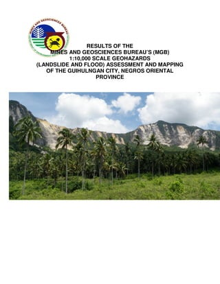
- 1. RESULTS OF THE MINES AND GEOSCIENCES BUREAU’S (MGB) 1:10,000 SCALE GEOHAZARDS (LANDSLIDE AND FLOOD) ASSESSMENT AND MAPPING OF THE GUIHULNGAN CITY, NEGROS ORIENTAL PROVINCE April 2012
- 2. RESULTS OF THE MINES AND GEOSCIENCES BUREAU’S (MGB) 1:10,000 SCALE GEOHAZARDS (LANDSLIDE AND FLOOD) ASSESSMENT AND MAPPING OF THE GUIHULNGAN CITY, NEGROS ORIENTAL PROVINCE The Mines and Geosciences Bureau (Central Office)-Department of Environment and Natural Resources (MGB-DENR) conducted landslide and flood assessment and mapping (1:10,000 scale) of areas within the city of Guihulngan on April 12 to 14, 2012. Comprising the geohazards assessment team are geologists from the MGB-Central Office (MGB-CO) namely Dr. Karlo L. Queaño, Ms. Gina May P. Mercado, Ms. Carleen Joy R. Telles and Ms. Christine Jeiselle G. Guarino. They were assisted by Mr. Godfrey F. Gemal, Mr. Renan C. Gatdula and Mr. Edward K. Tolero also from the MGB-CO. The assessment is in line with the government’s efforts aimed at reducing, if not, totally mitigating the destructive effects and impacts of natural hazards on the populace. The assessment is also a follow-up to the geohazards assessment and mapping (1:50,000 scale) conducted in May 2009 by geologists from MGB Central Office and Region VII (See Appendix I). The assessment was only limited to areas covered by the 1:10,000 scale base maps provided to the team. The assessed areas were rated as having low, moderate, high or very high (critical) susceptibility to landslide. Similar flood susceptibility rating (i.e., high, moderate or low) was also given to the assessed barangays. Tables 1 and 2 show the parameters used for the assessment. When appropriate, the barangay officials were presented with a Landslide Threat Advisory. This advisory informs them of their area’s susceptibility to landslides and contains the corresponding recommendations. Notable results were obtained by the MGB-DENR from the following barangays: Bakid, Balogo, Banwague, Bulado, Buenvista, Calamba, Hilaitan, Hinakpan, Humay-Humay, Kagawasan, Mabunga, Magsaysay, Malusay, Mani-ak, McKinley, Nagsaha, Poblacion, Planas, P Zamora, Tacpao, T-Beach, T-Hill and Villegas. These results are tabulated in Tables 4 and 5.
- 3. Table 1. Landslide susceptibility parameters used during the assessment Landslide Low Moderate High Very High Susceptibility Paremeters A. Slope Low to Moderate to Steep to very Steep to very Gradient moderate steep (18°-35° steep (>35° ) ) steep (>35°) (<18° ) B. Weathering/ Slight to Moderate Intense; Soil Intense; Soil Soil moderate usually non- usually non- Characteristics cohesive cohesive C. Rock mass Very good to Fair Poor to very Poor to very strength good poor poor D. Ground Stable with no Soil creep and Inactive Active Stability identified other landslides landslides landslide indications for evident; evident; scars, either possible tension cracks tension cracks, old, recent or landslide present bulges, active occurrence are terracets, present. seepage present. E. Human May be an Initiated aggravating effects factor Table 2. Flood susceptibility parameters used during the assessment High flood Areas likely to experience flood heights of greater than 1.0 susceptibility meters and/or flood duration of more than 3 days. These areas are immediately flooded during heavy rains of several hours; include landforms of topographic lows such as active river channels, abandoned river channels and areas along river banks; also prone to flashfloods. Moderate flood Areas likely to experience flood heights of 0.5 to 1.0 meters susceptibility and/or flood duration of 1 to 3 days. These areas are subject to widespread inundation during prolonged and extensive heavy rainfall or extreme weather condition. Fluvial terraces, alluvial fans, and infilled valleys are areas moderately subjected to flooding. Low flood Areas likely to experience flood heights of less than 0.5 susceptibility meter and/or flood duration of less than 1 day. These areas include low hills and gentle slopes. They also have sparse to moderate drainage density
- 4. Table 3. Results of Landslide Assessment Landslide Location Susceptibility Remarks/ Recommendations Rating Barangay Bakid Sitio Luho High Rotational and translational landslides, rock falls are present in the steep slopes of Sitio Luho. Tension cracks were observed on a hill slope along the trail of the area. Cracks along the road of Sitio Luho are also present. Recommendations: Observe for and/or monitor for presence of mass movement and report to the MGB/municipal authorities (e.g., landslides, tension cracks); Observe for saturated ground or seeps and sunken or displaced road surfaces and report to the MGB/municipal authorities. Develop an early warning system (e.g. signages). Barangay Balogo Mountainous High Barangay is bounded by steep slopes, portions of the hence, settlement at the foot of the barangay slope is highly discouraged. Recommendations: Observe for and/or monitor for presence of mass movement and report to the MGB/municipal authorities (e.g., landslides, tension cracks); Observe for saturated ground or seeps and sunken or displaced road surfaces and report to the MGB/municipal authorities. Barangay Proper Low to Barangay proper is located at a relatively Moderate flat area; however, several portions of the hills bounding the barangay proper exhibit creeping. Tension cracks were also noted in the vicinity of Balogo Elemetary School. Recommendations: Observe for and/or monitor for presence of mass movement and report to the MGB/municipal authorities (e.g., landslides, tension cracks); Observe for saturated ground or seeps and sunken or displaced road surfaces and report to the MGB/municipal authorities.
- 5. Sitio Cantupas High Numerous landslides/rockslides both active and inactive were noted in the area. A reactivated translational slide was observed in a portion of the Sitio, where a casualty was reported in a landslide event in 2001. Tension cracks are also present near the crown of an old landslide on the trail going to Sitio Panigsulang. Recommendations: Observe for and/or monitor for presence of mass movement and report to the MGB/municipal authorities (e.g., landslides, tension cracks); Observe for saturated ground or seeps and sunken or displaced road surfaces and report to the MGB/municipal authorities. Sitio Cangcuybo Moderate to Portions of the Sitio located on relatively High flat-lying areas have moderate landslide susceptibility. Active creeping was noted in the slopes of the hills bounding the flat- lying areas. Tension cracks and old and reactivated landslides were observed in the mountainous portions, which makes the area highly susceptible to landslides. Recommendation: Settlement near the foot of the slopes and along areas of active gully development is discouraged. Observe for and/or monitor for presence of mass movement and report to the MGB/municipal authorities (e.g., landslides, tension cracks); Observe for saturated ground or seeps and sunken or displaced road surfaces and report to the MGB/municipal authorities. Sitio Hinugpayan Low to The area is characterized by gentle, rolling Moderate topography. Active creeping was noted in the area. Recommendations: Observe for and/or monitor for presence of mass movement and report to the MGB/municipal authorities (e.g., landslides, tension cracks); Observe for saturated ground or seeps and sunken or displaced road surfaces and report to the MGB/municipal authorities.
- 6. Sitio Panigsulang High Sitio is located along the slopes of the mountainous areas of the barangay. Numerous landslides/rockslides were observed in the area. Tension cracks were noted in the vicinity. Four (4) houses were relocated following the February 6 earthquake. Settlement should be discouraged along the slopes and in areas fronting active gully development. Recommendations: Observe for and/or monitor for presence of mass movement and report to the MGB/municipal authorities (e.g., landslides, tension cracks); Observe for saturated ground or seeps and sunken or displaced road surfaces and report to the MGB/municipal authorities. Barangay Banwague Barangay Proper / Low to Barangay Proper lies on relatively gentle Banwague Moderate topography. Slopes of the hills bounding Elementary School the barangay proper exhibit creeping. Several buildings of the Balogo Elementary School were severely damaged and were rendered unusable by the earthquake; the walls of one of the buildings experienced tilting after the earthquake. Recommendations: Observe for and/or monitor for presence of mass movement and report to the MGB/municipal authorities (e.g., landslides, tension cracks); Observe for saturated ground or seeps and sunken or displaced road surfaces and report to the MGB/municipal authorities.
- 7. Sitio Cansalacan Moderate to The area is bounded by steep hills with High numerous old and recent landslides. Tension cracks were noted, especially along the slopes of the hills bounding the tributaries of the Guinoba-an River. Recommendations: Observe for and/or monitor for presence of mass movement and report to the MGB/municipal authorities (e.g., landslides, tension cracks); Observe for saturated ground or seeps and sunken or displaced road surfaces and report to the MGB/municipal authorities. Sitio Lipata High The Sitio is situated on the hilly portions of the barangay. Numerous active and inactive landslides were noted in the area and several tension cracks were observed. Residents should be discouraged from building houses along and at the foot of the slopes, as well as in areas where active gully development were noted. Recommendations: Observe for and/or monitor for presence of mass movement and report to the MGB/municipal authorities (e.g., landslides, tension cracks); Observe for saturated ground or seeps and sunken or displaced road surfaces and report to the MGB/municipal authorities. Barangay Bulado Sitio Maculos High Widespread creep were noted, as indicated by terracettes. Along the road, small translational landslides were also noted. Area is situated on top of extremely jointed and moderately weathered interbedded sandstone and mudstone. Recommendations: Observe for and/or monitor for presence of mass movement and report to the MGB/municipal authorities (e.g., landslides, tension cracks); Observe for saturated ground or seeps and sunken or displaced road surfaces and report to the MGB/municipal authorities.
- 8. Barangay Buenvista Mountainous areas Moderate to Several areas have unstable slopes, as between the high indicated by tension cracks, terracetes and barangay proper old landslides. Settlement at the base of and Brgy. steep slopes must be discouraged. Kambulawan, Planas Observe for and/or monitor for presence of mass movement and report to the MGB/municipal authorities (e.g., landslides, tension cracks); Observe for saturated ground or seeps and sunken or displaced road surfaces and report to the MGB/municipal authorities. Sitio Ilihan High Slopes bounding the eastern portion of the Sitio already show signs of instability as indicated by the presence of large tension cracks and terracetes. The Sitio could act as a landslide debris accumulation zone. Relocation of residents should be seriously considered. Monitor the development of tension cracks in the area. Observe for saturated ground or seeps report to the MGB/municipal authorities. Sitio Malabuyocon High Tension cracks and terracetes have been noted on the slopes of the Sitio. A house on the affected slope (GPS reading: N 10o08’34.8”/ E 123o14’12.3”) must be relocated. Observe for and/or monitor for presence of mass movement and report to the MGB/municipal authorities (e.g., landslides, tension cracks); Observe for saturated ground or seeps and sunken or displaced road surfaces and report to the MGB/municipal authorities. Sitio Panubigan High Slopes bounding the barangay and facing the Buenavista River are highly unstable. Several large tension cracks, terracetes and active landslide have affected the slopes. Slope undercutting by the Buenavista River partly caused the instability of the ground. Relocation of houses on the slope must be considered.
- 9. Officials should closely monitor the development of landslides along the Buenavista River. The river should always be cleared of landslide debris to avoid artificial damming of the river and consequent flash flooding in the downstream areas (including the barangay proper). Barangay proper Low to Slopes behind the barangay proper and moderate fronting the Buenavista River should be closely monitored for erosion/ slope instability. Building of heavy structures must be avoided. Slopes along the (GPS reading: N 10o08’36”/ E 123o14’30.2”) road leading to the barangay proper are highly unstable. Slope stabilization measures must be implemented immediately. The perimeter fence of the Barangay Hall is tilting/creeping (improper design of the fence; weep holes may have to be made to drain the slope of water esp. during heavy rains). Observe for presence of mass movement (e.g., tension cracks, terracetes) in all portions of the barangay. Sitio Cantinape High The area was hit by a slide following an earthquake. Slopes behind the Sitio remain highly unstable. Relocating the Sitio should be seriously considered, as it is also flood- prone. Observe for and/or monitor for presence of mass movement and report to the MGB/municipal authorities (e.g., landslides, tension cracks); Observe for saturated ground or seeps and sunken or displaced road surfaces and report to the MGB/municipal authorities. Sitio Upper Culasi High Mountain slopes bounding the Sitio have high landslide susceptibility. Settlement at the footslope must be avoided. Sitio Lower Culasi Low Recommendations: Observe for and/or monitor for presence of mass movement and report to the MGB/municipal authorities (e.g., landslides, tension cracks).
- 10. Buenavista Low A natural drain behind the Buenavista Elementary School Elementary School exists. Officials should ensure that the floors of the classrooms are higher than the said drain to avoid water seepage. Barangay Calamba Barangay proper High This area is bounded by steep slopes. Numerous huge translation slides were observed along the national highway. Recommendations: Observe for and/or monitor for presence of mass movement and report to the MGB/municipal authorities (e.g., landslides, tension cracks); Observe for saturated ground or seeps and sunken or displaced road surfaces and report to the MGB/municipal authorities. Develop an early warning system (e.g. signages). Settlement at the foot of the slope is highly discouraged. Sitio Kinamoan High Huge rotational slide and widespread creep were observed in the area. Area is underlain by highly weathered and jointed interbedded sandstone and mudstone. Recommendations: Observe for and/or monitor for presence of mass movement and report to the MGB/municipal authorities (e.g., landslides, tension cracks); Observe for saturated ground or seeps and sunken or displaced road surfaces and report to the MGB/municipal authorities. Develop an early warning system (e.g. signages). Settlement at the foot of the slope is highly discouraged. Sitio Maantol High Barangay road and farmland were affected by slides, particularly rockfall. Huge boulder was noted to be hanging precariously on top of the slope. Recommendations: Observe for and/or monitor for presence of mass movement and report to the MGB/municipal authorities (e.g., landslides, tension cracks); Observe for saturated ground or seeps and sunken or displaced road surfaces and report to the MGB/municipal authorities. Avoid settlement at the footslope.
- 11. Sitio Pilaon High The sitio is bounded by steep and jointed slopes of interbedded sandstone and mudstone. Huge rotational slides were noted affecting the barangay road. Recommendations: Observe for and/or monitor for presence of mass movement and report to the MGB/municipal authorities (e.g., landslides, tension cracks); Observe for saturated ground or seeps and sunken or displaced road surfaces and report to the MGB/municipal authorities. Avoid settlement at the footslope. Barangay Hilaitan Sitio Marulao High Slopes bounding Sitio Marulao are relatively steep. Some sections appear to have already been weakened by the weathering of rocks underlying the slopes. Some of the rocks lie loosely on the slope. One house at Sitio Marulao landslide (GPS reading: N10o14’43.4”/ 123o18’55.4”) needs to be relocated. Observe for and/or monitor for presence of mass movement and report to the MGB/municipal authorities (e.g., landslides, tension cracks); Observe for saturated ground or seeps and sunken or displaced road surfaces and report to the MGB/municipal authorities. Sitio Busay Moderate to Slopes bounding the northern portion of high Sitio Busay proper have high landslide susceptibility. Old landslides were noted. Settlements should not be allowed at the foot slope. Ridge separating Lake Danao and Sitio Busay has developed tension cracks. This puts the an area (GPS: N10o14’44.6”/ 123o16’42.7 ”) at Sitio Busay at high risk to landslide. In addition, boulder-sized rocks lie precariously on the slope facing the said area, making it susceptible to rock fall. Relocation of the houses at the base of the slope should be seriously considered. In all areas at Sitio Busay. Observe for and/or monitor for presence of mass movement and report to the MGB/municipal authorities (e.g., landslides, tension cracks); Observe for saturated
- 12. ground or seeps and sunken or displaced road surfaces and report to the MGB/municipal authorities. Sitio Danao Moderate to Slopes bounding the road leading to Sitio high Danao have high landslide susceptibility. The former military detachment area has been affected by tension cracks and is bounded by slopes that are highly susceptible to landslide. This should not be used for settlement. In addition, slopes bounding Lake Danao have been affected by active and old landslides. Houses on the mid- and footslope should be considered for relocation. In all areas at Sitio Danao, observe for and/or monitor for presence of mass movement and report to the MGB/municipal authorities (e.g., landslides, tension cracks); Observe for saturated ground or seeps and sunken or displaced road surfaces and report to the MGB/municipal authorities. Barangay Hinakpan Barangay Proper Low to Barangay proper and daycare center is Moderate located on flat lying area bounded by cliff forming limestone with numerous old/ inactive rockslides. Active creeping and reactivated slides were also noted along the road going to the barangay proper. Recommendations: Observe for and/or monitor for presence of mass movement and report to the MGB/municipal authorities (e.g., landslides, tension cracks); Observe for saturated ground or seeps and sunken or displaced road surfaces and report to the MGB/municipal authorities Sitio Bonbon High Recent translational slides were noted in slopes of the mountains bounding the area. Old landslides and several tension cracks were also observed. Relocation sites should be identified for the farming community situated at the foot of the slopes. Recommendations: Observe for and/or monitor for presence of mass movement and report to the MGB/municipal authorities (e.g., landslides, tension cracks); Observe for saturated ground or seeps and sunken
- 13. or displaced road surfaces and report to the MGB/municipal authorities. Sitio Cantumapon Low to Old/ reactivated rockslides/ rockfalls were Moderate observed in the area, particularly along roadcuts. Active creeping and tension cracks were also noted in the slopes of the hills in the vicinity of the Sitio. Recommendations: Observe for and/or monitor for presence of mass movement and report to the MGB/municipal authorities (e.g., landslides, tension cracks); Observe for saturated ground or seeps and sunken or displaced road surfaces and report to the MGB/municipal authorities. Barangay Humay-Humay Humay-Humay Very Critical A recent translational slide located at the Elementary School southeast portion of the school. Numerous tension cracks were also noted, particularly at the school’s buildings. The school is underlain by highly weathered and jointed interbedded sandstone and mudstone. Recommendations: Observe for and/or monitor for presence of mass movement and report to the MGB/municipal authorities (e.g., landslides, tension cracks); Observe for saturated ground or seeps and sunken or displaced road surfaces and report to the MGB/municipal authorities. Develop an early warning system (e.g. signages). Relocation of the school is highly recommended. The school is unsuitable as an evacuation site, unless slope stabilization measures are implemented. Barangay proper High Numerous recent landslides were observed in the slopes bounding the brgy. proper. Sets of tension cracks were also noted on top of the the slopes bounding this area. Recommendations: Observe for and/or monitor for presence of mass movement and report to the MGB/municipal authorities (e.g., landslides, tension cracks); Observe for saturated ground or seeps and sunken or displaced road surfaces and report to the MGB/municipal authorities.
- 14. Sitio Tinofindon High Sets of tension cracks were observed in the (Slope bounding area. Houses located on top of the slope the brgy. proper) are at high risk to landslide particularly during extreme heavy rainfall. Recommendations: Observe for and/or monitor for presence of mass movement and report to the MGB/municipal authorities (e.g., landslides, tension cracks); Observe for saturated ground or seeps and sunken or displaced road surfaces and report to the MGB/municipal authorities. Develop an early warning system (e.g. signages). For residents located on top of the slope, identifying an evacuation or relocation site is highly recommended, unless slope stabilization measures are implemented. Barangay Kagawasan Bey-ang Moderate A translational landslide is present along the trail of Sitio Bey-ang, Brgy. Kagawasan. Landslide deposits are carried away during heavy rains by the creek below the landslide area. Large, wide cracks are found crossing the trail of Bey-ang, continuing up to nearby Brgy. Bakid and affecting a house. Creep is also observed in the area, as manifested by terracetes and tilted trees. Recommendations: Observe for and/or monitor for presence of mass movement and report to the MGB/municipal authorities (e.g., landslides, tension cracks); Observe for saturated ground or seeps and sunken or displaced road surfaces and report to the MGB/municipal authorities. Develop an early warning system (e.g. signages). Constant communication and updates with Brgy. Bakid on geohazard situation. Gabong Low The area is located on gently rolling hills. Creep is observed on some areas. A church is found on top of a creeping low hill. Further developments are highly discouraged. Relocation may be considered unless slope stabilization is observed.
- 15. Recommendations: Observe for and/or monitor for presence of mass movement and report to the MGB/municipal authorities (e.g., landslides, tension cracks); Observe for saturated ground or seeps and sunken or displaced road surfaces and report to the MGB/municipal authorities. Hilly portions of High Five rotational landslides are observed on Brgy. Kagawasan the hills of Brgy. Kagawasan near its facing Brgy. T- boundary with Brgy. T-beach. Settlement at beach the footslope of these hills is highly discouraged. Recommendations: Observe for and/or monitor for presence of mass movement and report to the MGB/municipal authorities (e.g., landslides, tension cracks); Observe for saturated ground or seeps and sunken or displaced road surfaces and report to the MGB/municipal authorities. Develop an early warning system (e.g. signages). Barangay Mabunga Sitios Buski, Critical Earthquake-induced landslide affected a Malabitoon, huge portion of a mountain at brgy. Panigsolang, Mabunga. Remobilization/ reactivation of Tamuag and the slide is likely, especially that tension Talayong cracks are still present near the crown of the slide. Such event puts sitios Buski, Malabitoon, Panigsolang, Talayong and Tamuag at high risk to landslide/ debris flow. Relocation of the sitios is strongly recommended. Barangay Magsaysay Sitio Giob High Translational slides were observed in the area. The sitio is also prone to rockfall. Recommendation: Observe for and/or monitor for presence of mass movement and report to the MGB/municipal authorities (e.g., landslides, tension cracks); Observe for saturated ground or seeps and sunken or displaced road surfaces and report to the MGB/municipal authorities
- 16. Barangay proper High Barangay proper is bounded by steep slopes where huge limestone boulders were observed to be hanging. Houses along the provincial road are threatened by rockfall. Recommendation: Observe for and/or monitor for presence of mass movement and report to the MGB/municipal authorities (e.g., landslides, tension cracks); Observe for saturated ground or seeps and sunken or displaced road surfaces and report to the MGB/municipal authorities. Removal of the boulders is strongly recommended. Sitio Malinoy High A huge translational slide is observed in the area. Houses at the footslope are at risk. Recommendation: Observe for and/or monitor for presence of mass movement and report to the MGB/municipal authorities (e.g., landslides, tension cracks); Observe for saturated ground or seeps and sunken or displaced road surfaces and report to the MGB/municipal authorities Barangay Malusay Barangay Proper Low Area is situated to relatively gentle slope. Recommendation: Observe for and/or monitor for presence of mass movement and report to the MGB/municipal authorities (e.g., landslides, tension cracks). Barangay Mani-ak Barangay Mani-ak Moderate to Slopes bounding Barangay Mani-ak and proper high those adjacent to the road leading to the barangay proper are highly susceptible to landslide. Water seepage was observed at the base of the slope in one of the areas at Barangay Mani-ak (GPS reading: o o N10 15’44.1”/ 123 16’30.4”). The seepage emanated following the strong earthquake in February 2012. Two houses at the base of the slope should be considered for relocation. Another house at Barangay proper (GPS reading: N10o15’45.5”/ 123o16’34.1”) is also recommended for relocation. Settlement at the base of
- 17. mountain slopes bounding the barangay should be avoided. Barangay Mc Kinley Barangay Proper Low Large cracks on the highway of McKinley were observed after the February 6, 2012 earthquake. Houses were badly destroyed due to land subsidence. Recommendations: Observe for and/or monitor for presence of mass movement and report to the MGB/municipal authorities (e.g., landslides, tension cracks); Observe for saturated ground or seeps and sunken or displaced road surfaces and report to the MGB/municipal authorities. Strengthening of the roads and foundation of houses is advised. Barangay Nagsaha Sitio Giob High Numerous translational slides are observed in the area. About 10 houses situated on footslope are at risk. Recommendation: Observe for and/or monitor for presence of mass movement and report to the MGB/municipal authorities (e.g., landslides, tension cracks); Observe for saturated ground or seeps and sunken or displaced road surfaces and report to the MGB/municipal authorities. Avoid settlements on footslopes. Barangay Poblacion Sitio Larena Critical Recent slide damaged 5 houses along the road at sitio Larena. Relocation of these houses is strongly recommended. Recommendation: Observe for and/or monitor for presence of mass movement and report to the MGB/municipal authorities (e.g., landslides, tension cracks); Observe for saturated ground or seeps and sunken or displaced road surfaces and report to the MGB/municipal authorities. Sitio Pisoc High A huge translational slide is observed along the road to sitio Pisoc.
- 18. Recommendation: Observe for and/or monitor for presence of mass movement and report to the MGB/municipal authorities (e.g., landslides, tension cracks); Observe for saturated ground or seeps and sunken or displaced road surfaces and report to the MGB/municipal authorities. Implement slope stabilization measures. Barangay Planas Sitio Kambulawan Moderate to Slopes bounding the southeastern portions High of the Sitio are highly susceptible to landslide. Tension cracks and terracets have been noted on the slopes. Slope failure could directly hit houses at the Sitio (e.g., those centered ~ in an area with GPS reading: N10o09’45.1”/ E 123o14’35.7”). Observe for and/or monitor for presence of mass movement and report to the MGB/municipal authorities (e.g., landslides, tension cracks); Observe for saturated ground or seeps and sunken or displaced road surfaces and report to the MGB/municipal authorities Sitio Mambog Low Sitio Mambog proper has low landslide susceptibility. The sitio is not recommended as a relocation/evacuation site for those affected by earthquake in February 2012 as it is a flood-prone area. A creek has started to devep in the Sitio. Slopes bounding the eastern side of Sitio Mambog have high landslide susceptibility. Observe for and/or monitor for presence of mass movement and report to the MGB/municipal authorities (e.g., landslides, tension cracks); Observe for saturated ground or seeps and sunken or displaced road surfaces and report to the MGB/municipal authorities. Closely coordinate with Brgy. Upper Moog. Landslide debris at the said barangay could be remobilized during continuous heavy rain and partly hit the Sitio (see results of flood susceptibility rating)
- 19. Sitio Lower Moog Moderate to Some slopes of the Sitio are experiencing high creep (as indicated by terracets; tilted trees; e.g., in an area with GPS reading of N 10o10’12.2”/ E 123o14’06.2”). Settlement on or at the foot of the slope should be discouraged. Brgy. officials should closely coordinate with those of Sitio Upper Moog where a big landslide occurred. Remobilization of landslide debris especially during heavy continuous rains could hit the Sitio. Recommendations: Observe for and/or monitor for presence of mass movement and report to the MGB/municipal authorities (e.g., landslides, tension cracks); Observe for saturated ground or seeps and sunken or displaced road surfaces and report to the MGB/municipal authorities. Sitio Upper Moog High The Sitio was recently hit by a huge landslide. Being the case (and especially that the Sitio appears to be located on an old landslide deposit), the area where landslide occurred should be declared as a permanent danger zone. Several huge tension cracks remain near the crown of the landslide. Remobilization of the landslide debris is likely especially during heavy continuous rains. All drainages/creeks should be cleared of landslide debris as this could cause artificial damming and consequently flashflooding of areas downstream. Settlement near the landslide area (including near the crown and toe) is highly discouraged. Other slopes at Sitio Upper Moog also show signs of instability (e.g., terracetes, tension cracks at the crown and toe of the slide). Residents should closely monitor the development of the said crack (GPS: N 10o10’15.9”/ E 123o14’05.1”). Observe for and/or monitor for presence of mass movement and report to the MGB/municipal authorities (e.g., landslides, tension cracks); Observe for saturated ground or seeps and sunken or displaced road surfaces and report to the MGB/municipal
- 20. authorities. Barangay proper Moderate to Slopes bounding the basketball court and high elementary school are very unstable. Tension cracks, terracetes and old and recent slides were observed. Further developments near the affected slopes should not be allowed. (GPS: N10o10’28.9”/ E 123o14’33.4”). Barangay P. Zamora Sitio Pitogo High Large tension cracks (~1-1.5 m wide and 5 m deep) and a creep were observed in the Sitio Pitogo, Brgy. P. Zamora. A part of the road was uplifted and destroyed due to the February 2012 earthquake. Settlement at the cracked slopes are highly discouraged. Recommendations: Observe for and/or monitor for presence of mass movement and report to the MGB/municipal authorities (e.g., landslides, tension cracks); Observe for saturated ground or seeps and sunken or displaced road surfaces and report to the MGB/municipal authorities. Develop an early warning system (e.g. signages). Barangay Tacpao Sitio Kambang High Numerous landslides were noted along the barangay road leading to barangay proper. Boulder-sized debris were observed along barangay road. Recommendation: Observe for and/or monitor for presence of mass movement and report to the MGB/municipal authorities (e.g., landslides, tension cracks); Observe for saturated ground or seeps and sunken or displaced road surfaces and report to the MGB/municipal authorities. Develop an early warning system (e.g. signages). Near the boundary High Recent landslide was noted on the Macalua of Brgys. Tacpao Farm. and Binobohan Recommendation: Observe for and/or monitor for presence of mass movement and report to the MGB/municipal authorities (e.g., landslides, tension cracks); Observe for saturated ground or seeps and sunken
- 21. or displaced road surfaces and report to the MGB/municipal authorities. Develop an early warning system (e.g. signages). Sitio Lagaan High Huge translational landslides were noted on the steep slope bounding the area. Tension cracks were also reported on top of this slope. Recommendation: Observe for and/or monitor for presence of mass movement and report to the MGB/municipal authorities (e.g., landslides, tension cracks); Observe for saturated ground or seeps and sunken or displaced road surfaces and report to the MGB/municipal authorities. Develop an early warning system (e.g. signages). Settlement at the footslope is highly discouraged. Sitio Macaang-ang High Numerous translation landslides were observed on the steep slopes. Recommendation: Observe for and/or monitor for presence of mass movement and report to the MGB/municipal authorities (e.g., landslides, tension cracks); Observe for saturated ground or seeps and sunken or displaced road surfaces and report to the MGB/municipal authorities. Develop an early warning system (e.g. signages). Settlement at the footslope is highly discouraged. Sitio Cabanog High In 2009 MGB’s Geohazards report, the area was affected by a landslide damaging at least 4 houses. Recommendations: Observe for and/or monitor for presence of mass movement and report to the MGB/municipal authorities (e.g., landslides, tension cracks); Observe for saturated ground or seeps and sunken or displaced road surfaces and report to the MGB/municipal authorities. Barangay proper Moderate Area is located on rolling to moderately- steep slope. Recommendation: Observe for and/or monitor for presence of mass movement and report to the MGB/municipal authorities (e.g., landslides, tension cracks); Observe for saturated ground or seeps and sunken
- 22. or displaced road surfaces and report to the MGB/municipal authorities. Barangay T-Beach Botong High Tension cracks, approximately 1 ft wide, are observed at the top of a hill in Sitio Botong of Brgy. T-beach. A huge rotational landslide is also present in the area. Recommendation: Observe for and/or monitor for presence of mass movement and report to the MGB/municipal authorities (e.g., landslides, tension cracks); Observe for saturated ground or seeps and sunken or displaced road surfaces and report to the MGB/municipal authorities. Bebe High Landslide debris of several succeeding huge translational slides covered the road trail of Sitio Bebe in Brgy. T-beach. Recommendations: Observe for and/or monitor for presence of mass movement and report to the MGB/municipal authorities (e.g., landslides, tension cracks); Observe for saturated ground or seeps and sunken or displaced road surfaces and report to the MGB/municipal authorities. Develop an early warning system (e.g. signages). Back of Filomena High A steep slope is creeping towards the back Elementary School of Filomena Elementary School. Soil from the slope subsided and partially buried the back of the school after the recent, February 2012 earthquake. A house seating on top of the steep slope is advised to be relocated. Recommendations: Observe for and/or monitor for presence of mass movement and report to the MGB/municipal authorities (e.g., landslides, tension cracks); Observe for saturated ground or seeps and sunken or displaced road surfaces and report to the MGB/municipal authorities. Develop an early warning system (e.g. signages). Evacuation of children in Filomena Elementary School is advised during unfavorable weather conditions (e.g. typhoons, heavy rains), unless slope stability measures are observed.
- 23. Barangay T-Hill Sitio Bulay Critical A huge translational slide and tension cracks are observed on steep slopes bounding the area. Relocation of 5 houses very near the slide is strongly recommended. Recommendations: Observe for and/or monitor for presence of mass movement and report to the MGB/municipal authorities (e.g., landslides, tension cracks); Observe for saturated ground or seeps and sunken or displaced road surfaces and report to the MGB/municipal authorities. Develop an early warning system (e.g. signages). Sitio Kandaislan Critical A translational slide affected a mountainous portion of the sitio. 10 houses at the footslope are at risk and must be relocated. Recommendations: Observe for and/or monitor for presence of mass movement and report to the MGB/municipal authorities (e.g., landslides, tension cracks); Observe for saturated ground or seeps and sunken or displaced road surfaces and report to the MGB/municipal authorities. Develop an early warning system (e.g. signages). Sitio Batang High Translational slides are observed on a slope bounding the sitio. Recommendations: Observe for and/or monitor for presence of mass movement and report to the MGB/municipal authorities (e.g., landslides, tension cracks); Observe for saturated ground or seeps and sunken or displaced road surfaces and report to the MGB/municipal authorities. Develop an early warning system (e.g. signages). Sitio Tubod High Several active translational slides are observed. A house built adjacent to the slide area should be relocated. Recommendations: Observe for and/or monitor for presence of mass movement and report to the MGB/municipal authorities (e.g., landslides, tension cracks); Observe for saturated ground or seeps and sunken
- 24. or displaced road surfaces and report to the MGB/municipal authorities. Develop an early warning system (e.g. signages). Avoid settlements on footslopes. Barangay Villegas Barangay proper Low to An unstable ground exists adjacent to the and elementary moderate Brgy. Villegas Elementary School. Trees school must be trimmed to lessen the stress on the ground due to swaying. Drainage canal should be paved to avoid erosion of the ground adjacent to the school. Slopes bounding the school should not be left unprotected. Slopes beside the basketball court has high landslide susceptibility. Observe for and/or monitor for presence of mass movement and report to the MGB/municipal authorities (e.g., landslides, tension cracks); Observe for saturated ground or seeps and sunken or displaced road surfaces and report to the MGB/municipal authorities. Sitio Lower Malho Moderate Slopes (e.g., GPS: N 10o10’03.4/ E 123o13’51”) bounding Sitio Malho are affected by terracetes/creeping. Observe for and/or monitor for presence of mass movement and report to the MGB/municipal authorities (e.g., landslides, tension cracks); Observe for saturated ground or seeps and sunken or displaced road surfaces and report to the MGB/municipal authorities. Sitio Upper Malho High Several slopes bounding Sitio Upper Malho developed tension cracks. These include those near the landslide area at Sitio Upper Moog, Brgy. Planas. A number of slides were also noted. Houses situated at the mid, at the base and in the vicinity of the slope where tension cracks have been noted should be considered for relocation. Sitio Mantuhod High Slopes near the area where landslide that affected Sitio Upper Moog, Brgy. Planas have developed tension cracks. Houses on and near the slope should be relocated. (e.g., those with GPS reading centered at N 10o10’51.5”/ E 123o13’40.3”. Mounanous areas surrounding Sitio Mantuhod have high landslide susceptibility.
- 25. Observe for and/or monitor for presence of mass movement and report to the MGB/municipal authorities (e.g., landslides, tension cracks); Observe for saturated ground or seeps and sunken or displaced road surfaces and report to the MGB/municipal authorities. Sitio Agimit Low to Observe for and/or monitor for presence of moderate mass movement and report to the MGB/municipal authorities (e.g., landslides, tension cracks); Observe for saturated ground or seeps and sunken or displaced road surfaces and report to the MGB/municipal authorities. Sitio Lower High A hilly area at Sitio Lower (GPS reading: N 10o10’46.8”/ E 123o13’17.1) some distance away from the barangay proper has high landslide susceptibility. Floats of rocks (remnants of previous rock fall) were observed. Relocation of remaining household should be done immediately. Observe for and/or monitor for presence of mass movement and report to the MGB/municipal authorities (e.g., landslides, tension cracks); Observe for saturated ground or seeps and sunken or displaced road surfaces and report to the MGB/municipal authorities. Table 4. Results of Flood Hazard Assessment Lanslide Location Susceptibility Remarks/ Recommendations Rating Barangay Balogo Sitio Cansalacan High Portions of Sitio Cansalacan, particularly those that are situated at the floodplains of a tributary of the Guinoba-an River are highly prone to flooding. Some residential areas as well as agricultural lands in the Sitio are affected by sheet and flash flooding. Recommendations: Observe for rapid increase/decrease in creek/river water
- 26. levels, possibly accompanied by increased turbidity (soil content). Implement flood control measures. Sitio Cantupas High Sitio Cantupas is highly prone to flash flooding. Landslide debris from the unstable slopes of the mountains bounding the Guinoba-an River could lead to artificial damming of the said river. Recommendations: Observe for rapid increase/decrease in creek/river water levels, possibly accompanied by increased turbidity (soil content). Barangay Calamba Barangay proper High Area is prone to flooding and flashflood. Landslides on upstream may cause artificial damming that could lead to flashflood, during heavy rainfall. Recommendations: Observe for rapid increase/decrease in creek/river water levels, possibly accompanied by increased turbidity (soil content). Implement flood control measures. Observe for and/or monitor for presence of mass movement on the upstream. Barangay Mabunga Sitio Malabitoon High Area is prone flashflood. Two houses were severely affected during Typhoon Ruping. Recommendations: Observe for rapid increase/decrease in creek/river water levels, possibly accompanied by increased turbidity (soil content). Observe for landslides in the upstream portion as this could lead to artificial damming. Barangay McKinley Brgy. Proper Moderate Sea walls were broken by the February 6, 2012 earthquake thus decreasing the protection of the area from storm surges. Evacuation of the residents near the coast with broken sea walls is advised during typhoons, unless a stronger barrier is reconstructed. Canals were also narrowed and clogged by displaced soil, thus
- 27. increasing the probability of floods during heavy rains. Recommendations: Development of early warning device/system. Residents of the coastal areas with broken sea walls are advised to evacuate to the higher flat areas during strong typhoons. Canals must be re- excavated to prevent drainage-related flooding in the area. Barangay P. Zamora Areas along the P. High Settlement near the river banks is highly Zamora River discouraged. Recommendations: Develop an early warning device/system. Observe for rapid increase/decrease in creek/river water levels, possibly accompanied by increased turbidity (soil content). Evacuation of the residents, along the banks of P. Zamora River, to P. Zamora Elementary School during heavy rains and strong typhoons is advised. Barangay Tacpao Sitio Cambanog High In 2009 MGB’s Geohazards Report, houses near Cansuhi Creek and Sitio Cambanog were affected by floodwater. Recommendations: Observe for rapid increase/decrease in creek/river water levels, possibly accompanied by increased turbidity (soil content). Implement flood control measures. It should be noted that these susceptibility ratings were arrived at as of this field assessment. However, the rating could advance (e.g., from low to moderate, moderate to high). Hence, the MGB constantly recommends strict and continuous monitoring by the barangays.
- 28. MGB GEOHAZARD ASSESSMENT TEAM Karlo L. Queaño, Ph.D. Gina May P. Mercado Supv. Science Research Specialist Senior Science Research Specialist Team Leader Carleen Joy R. Telles Christine Jeiselle G. Guarino Senior Science Research Specialist Science Research Specialist - II Prepared by: Godfrey F. Gemal Renan C. Gatdula Contractual Employee Contractual Employee