![[object Object],[object Object],[object Object],[object Object],[object Object],[object Object],[object Object]](data:image/gif;base64,R0lGODlhAQABAIAAAAAAAP///yH5BAEAAAAALAAAAAABAAEAAAIBRAA7)
Recomendados
Recomendados
Mais conteúdo relacionado
Mais procurados
Mais procurados (19)
Semelhante a Storm Chasing Forecast Tools and Techniques
Semelhante a Storm Chasing Forecast Tools and Techniques (20)
Último
Último (20)
Storm Chasing Forecast Tools and Techniques
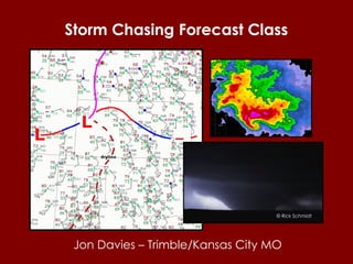
- 1. Storm Chasing Forecast Class Jon Davies – Trimble/Kansas City MO © Rick Schmidt
- 3. 74 62 051 Air pressure in millibars (upper right) (here 1005.1 mb) Temperature (upper left) (in o F on surface maps, here 74 o F ) Dew point (lower left) (a measure of moisture, in o F on surface maps, here 62 o F ) Wind direction and speed (here from the south-southwest at 15 knots) Line extending outward gives direction from which wind is blowing, barb gives speed in knots (kts): full barb = 10 kts; ½ barb = 5 kts (1 knot = 1.15 miles per hour) Basic surface station weather observation plot Current weather (middle left) (here, light rain) Station location
- 4. Boundaries that separate different air masses are called fronts:
- 5. A dryline is a boundary between dry air to the west and moist air to the east. Moist air (high dew points) Dry air (low dew points) dryline
- 7. Wind flow around low pressure is counterclockwise with air spiraling inward toward the center. Wind flow around high pressure is clockwise with air spreading outward from the center.
- 10. Older thunderstorms or clusters of storms can produce boundaries due to cool air flowing outward from some of the storms. These outflow boundaries can behave like small cold fronts, warm fronts or stationary fronts. outflow boundary from storms over southeast KS and southwest MO
- 12. Satellite and radar information can help with weather map analysis. Radar Satellite
- 18. This 500 mb map (~ 18,000 ft MSL) is the result of information from radiosondes:
- 19. Radiosondes released twice per day (6 a.m. CST and 6 p.m. CST) give us weather observations above the ground. Radiosonde : a box equipped with weather instruments and a radio transmitter attached to a gas-filled balloon. North American radiosonde sites
- 20. Weather maps above ground are important because they tell us a lot about what will be going on with our weather at the ground. Changes in the upper pressure and wind patterns and the jet stream help meteorologists to predict significant changes in our weather.
- 21. Jet stream warm Jet stream cold warm cold
- 22. Jet stream (purple) (18,000-30,000 ft MSL) surface fronts Where jet stream winds and upper flow dip south, weather becomes colder Where jet stream winds and upper flow bulge north, weather becomes warmer Relationship of jet stream and upper winds to fronts trough ridge Surface fronts are usually located close to and beneath the jet stream !
- 23. The jet stream winds generally run along the tighter contours of weather maps at 500 mb (roughly 18,000 ft above sea level) and 300 mb (roughly 30,000 ft above sea level). These contours make troughs and ridges in the flow aloft that greatly affect our weather at the ground.
- 24. wind flow and contours at roughly 18,000 ft MSL (500 mb) general cloudiness & storminess (divergence aloft – winds spreading apart to create lift) less clouds & “nicer” weather (convergence aloft- winds pushing together to create sinking) Troughs and ridges are waves aloft … wave wave
- 25. Shortwaves (smaller waves of energy in the upper flow) move through the larger troughs and ridges (longwaves), generating more concentrated areas of clouds and storminess within the larger troughs and ridges.
- 26. Longwave trough 500 mb ~ 18,000 ft MSL Longwave ridge Longwave trough Shortwave Shortwave Shortwave
- 27. Longwave trough 500 mb ~ 18,000 ft MSL Longwave ridge Longwave trough Shortwave Shortwave rising motion (clouds & storms) rising motion (clouds & storms) Shortwave rising motion (clouds & storms) sinking motion (better weather) sinking motion (better weather) sinking Note the areas of weather just ahead of these waves aloft – these shortwaves “plow up” the atmosphere, so to speak, to create lift and storminess.
- 28. Fronts also tend to move with the stronger wave disturbances aloft in the jet stream. ? strong shortwave aloft strong shortwave aloft surface front surface front dryline 500 mb contours and surface systems (a spring storm)
- 29. 300 mb 500 mb surface 30,000 ft (9 km MSL) 18,000 ft (5.5 km MSL) Ground level L H L L H cold cold cold warm warm warm H H Upper air maps, different “slices” through the atmosphere at increasing elevations, help meteorologists understand and predict all this weather.
- 30. Tornadic supercells possible S or SE surface winds & sizable CAPE (instability) (warm air & large dew points) L Divergence Winds veer (become more westerly) and increase with height Jet stream and divergence aloft (winds spreading apart) with upper trough / wave Meteorological setting for possible supercells and tornadoes Ground level MSL (5.5 km) MSL (3.0 km) MSL (1.5 km) MSL (9.0 km)
- 31. Ground level L divergence Meteorological setting for possible supercells and tornadoes We’ll look mainly at these levels aloft. MSL (5.5 km) MSL (3.0 km) MSL (1.5 km) MSL (9.0 km) ‘ upper levels’ ‘ mid levels’ ‘ low levels’
- 32. Ground level L divergence Notice that the “ mb” numbers (850 – 700 – 500 - 300) get smaller with height, just the opposite of elevation . Meteorological setting for possible supercells and tornadoes MSL (5.5 km) MSL (3.0 km) MSL (1.5 km) MSL (9.0 km) ‘ upper levels’ ‘ mid levels’ ‘ low levels’
- 33. ~ 18,000 ft / 5.5 km MSL Eta/NAM/WRF model forecast from UCAR site
- 34. ~ 10,000 ft / 3.0 km MSL Eta/NAM/WRF model forecast from UCAR site
- 35. ~ 5,000 ft / 1.5 km MSL Eta/NAM/WRF model forecast from UCAR site
- 36. Surface Eta/NAM/WRF model forecast from UCAR site
- 38. Computer model forecasts use current data observations to initialize numerical models that approximate the atmosphere’s behavior. These models are then “run” forward in time using a computer to solve physical equations to make a forecast.
- 39. GFS (Global Forecast System): goes out to 16 days (usually displayed only out to 7 or 10 days), run 4 times per day (the 12z morning & 00z evening runs are best!) NAM (North American Mesoscale): goes out to 3.5 days (84 hours), run 4 times per day (again, the 12z morning & 00z evening runs are best!) (also called the WRF or Eta) RUC (Rapid Update Cycle): goes out to 18 hours (usually displayed only out to 12 hours), run hourly. (The NAM & RUC have higher resolution and more detail) Here are the main computer models that are run and maintained by the National Weather Service (National Centers for Environmental Prediction, or NCEP) and used by most forecasters:
- 40. The GFS is used to look farther ahead (out to 2 weeks), but it is very unreliable beyond 5-7 days. The early panels can also be used as a comparison to the NAM. The NAM/WRF/Eta is used to look out to 3 days or so, and is more detailed than the GFS. The panels out to 12 hours can also be used as a comparison to the RUC. The RUC is used the day of an impending event and is updated frequently with available current observations for even more detail.
- 41. You can access output from these models at many internet sites… The UCAR site above has been around for a long time: www.rap.ucar.edu/weather
- 42. RUC NAM(Eta/WRF) GFS
- 43. Some other sites with computer model forecast output: Earl Barker’s site: www.wxcaster.com/conus_0012_us_models.htm (NAM/WRF & GFS) www.wxcaster.com/conus_offhr_models.htm (RUC) College of DuPage: weather.cod.edu/forecast (RUC, NAM/WRF, & GFS) TwisterData: www.twisterdata.com (RUC, NAM/WRF, & GFS) Unisys Weather: weather.unisys.com (RUC, NAM/WRF & GFS)
- 44. Example of computer model output: 12 hr forecast NAM model CAPE (instability) UCAR site: www.rap.ucar.edu/weather/model
- 45. Example of computer model output: 12 hr forecast RUC model 3 hr accumulated precipitation Earl Barker’s site: www.wxcaster.com/conus_offhr_models.htm (RUC)
- 46. Example of computer model output: day 2 through day 10 forecast GFS 10 day 500 mb contours (colors) and surface isobars (black) Unisys site: weather.unisys.com
- 47. Example of computer model output: 180 hr forecast GFS 6 hr accumulation precipitation forecast at 7.5 days TwisterData site: www.twisterdata.com
- 49. Part of the job of meteorologists making forecasts is to use their knowledge and experience to determine when model guidance is reasonably accurate and useful, and when it is not. Accepting computer model forecast output without question and thought is not really weather forecasting. True weather forecasting requires experience! However, one can make a quick “forecast guess” for a tornado chase by looking at only a few panels of model output. Just understand that is only a crude guide based on a computer’s “opinion”, rather than a true forecast.
- 51. Then, subtract the proper number of hours for your time zone from the UTC time to get your local time in a 24-hr or “military” time system. UTC is Universal Time Coordinated, the same as Greenwich Mean Time (GMT) or Zulu time (Z). To convert from UTC time to local time: First, learn to think in a 24-hr time system (“military time”):
- 52. Pacific Time Zone: Subtract 8 hours from the UTC time to get PST time. Subtract 7 hours from the UTC time to get PDT time. Mountain Time Zone: Subtract 7 hours from the UTC time to get MST time. Subtract 6 hours from the UTC time to get MDT time. Central Time Zone: Subtract 6 hours from the UTC time to get CST time. Subtract 5 hours from the UTC time to get CDT time. Eastern Time Zone: Subtract 5 hours from the UTC time to get EST time. Subtract 4 hours from the UTC time to get EDT time. ST = Standard time DT = Daylight time
- 55. 0000 UTC = 6:00 p.m. CST = 7:00 p.m. CDT 0300 UTC = 9:00 p.m. CST = 10:00 p.m. CDT 0600 UTC = midnight CST = 1:00 a.m. CDT 0900 UTC = 3:00 a.m. CST = 4:00 a.m. CDT 1200 UTC = 6:00 a.m. CST = 7:00 a.m. CDT 1500 UTC = 9:00 a.m. CST = 10:00 a.m. CDT 1800 UTC = noon CST = 1:00 p.m. CDT 2100 UTC = 3:00 p.m. CST = 4:00 p.m. CDT Table converting Universal Time (UTC) to Central Time (CST or CDT): Or, if all this seems too complicated, you can memorize the time conversions for your specific time zone, and work from there:
- 56. Also, remember that dates change backwards a day when doing evening and early nighttime UTC time conversions. Above, 0000 UTC 5 May 2007 is actually 7:00 pm CDT 4 May 2007 and, 00 UTC 21 February 2011 is actually 6:00 pm CST 20 February 2011
- 60. (CAPE) convective available potential energy Yellow area is where lifted low-level air parcels are warmer than their environment -- a “positive” area Large CAPE means the atmosphere is very unstable. Moisture profile Temperature profile SkewT-log p diagram – a thermodynamic diagram
- 66. Wind at 6 km above ground (near 500 mb) (from SSW at 20 kts) Wind at ground level (from SSE at 15 kts) 0-6 km bulk shear is the straight-line vector difference between 2 vectors: the surface wind, and the wind at 6 km above ground. Wind at 6 km above ground (near 500 mb)(from SW at 47 kts) Wind at ground level (from SSE at 15 kts) Here, the 0-6 km bulk shear is only 7 kts ( very poor ) Here, the 0-6 km bulk shear is around 40 kts ( very good for supporting supercells)
- 69. © Craig Setzer and Al Pietrycha Tornadoes develop from low-level mesocyclones (strong rotation near the ground) in supercells. Strong wind shear is needed in the supercell environment near the ground to generate low-level mesocyclones.
- 71. 0-1 km SRH is a measure of low-level wind shear -- it measures the area under the wind profile “curve” below 1 km... The larger the curve, the larger the low-level wind shear. Winds at increasing 200 m intervals above ground up to 1 km (1000 m) (winds increase in speed & become more southwesterly with height) Wind at ground level (from SE at 15 kts) Wind at 1 km above ground (just below 850 mb) (from SW at 35 kts) Here, the 0-1 km SRH is around 210 m 2 /s 2 ( good enough when combined with 2000-2500 J/kg of CAPE or more to support low-level meoscyclones & possible tornadoes) This red line is a hodograph Good low-level wind profile for supercell tornadoes
- 72. 0-1 km SRH is a measure of low-level wind shear -- it measures the area under the wind profile “curve” below 1 km... The larger the curve, the larger the low-level wind shear. Winds at increasing 200 m intervals don’t increase in speed with height, and the wind profile is “small” with not much of a “curve” Wind at ground level (from SE at 15 kts) This red line is a hodograph Here, the 0-1 km SRH is only around 70 m 2 /s 2 ( very poor for supporting low-level meoscyclones & tornadoes) Poor low-level wind profile for supercell tornadoes Wind at 1 km above ground (just below 850 mb) (from SSW at 19 kts)
- 73. 5/13/09 NW Missouri (non-tornadic supercell) 5/13/09 NC Missouri (EF2 tornadic supercell) 0-1 km SRH from contrasting hodographs 0-1 SRH = 70 m 2 /s 2 0-1 SRH = 430 m 2 /s 2 poor very good
- 75. Tilting and stretching of horizontal vorticity (low-level wind shear): Low-level mesocyclones, possible tornadoes? Combinations of CAPE and SRH are important for this process.
- 76. ? Energy-Helicity Index (EHI) shows combinations of CAPE and SRH.
- 79. Divergence ahead of strong 500 mb trough -- spreading of winds causes upward motion to trigger storms
- 80. cooling with height cooling with height warming with height capping inversion moisture profile temperature profile SkewT-log p diagram – a thermodynamic diagram CAPE above capping inversion can’t be realized capping inversion is near 700 mb
- 81. March approx > 5-6 o C April approx > 7-8 o C May approx > 9-11 o C June approx > 12-13 o C August approx > 12 o C September approx > 9-11 o C October approx > 7-8 o C November approx > 5-6 o C 700 mb temperature estimations of areas that are “capped” (too warm aloft for thunderstorms): Spring Fall This chart doesn’t work well in the western High Plains due to elevation (e.g., eastern NM, eastern CO, far western NE, etc.).
- 82. Capping not an issue in this case (far south of target area) Storms initiating?
- 83. Model shows storms initiating
- 86. tornadic cell (EF2) tornadic cell (EF1) Real observations…
- 88. A word about storm motion… It’s important to get an idea of which direction and how fast mature storms and supercells will be moving on a given day. That way you can intercept more effectively, and also plan quickly to get out of the way when you have to. You can use the 500 mb winds to make a very rough storm motion estimate (about 1/2 to 2/3rds the 500 mb wind speed and slightly to the right of the direction). You can also find more specific storm motion estimates on some computer model sites, such as Twisterdata.
- 94. Sig Tor Parameter (STP) incorporates CAPE, SRH, deep shear, & LCL height into one parameter Target?
- 95. Real observations… Front farther south than model forecasts
- 96. Tornadic storm (EF3), much farther south than original target near front Non-tornadic storms well north of surface stationary front Real observations…
- 97. SPC mesoanalysis http://www.spc.noaa.gov Near real-time estimation from SPC site…
- 98. © Jon Davies EF3 tornado near Hill City KS
- 99. Here’s another case comparing model output, This time starting a little farther out in time (48 hrs), and then moving on up to making target adjustments during the day of the actual chase…
- 102. 48-hr “radar echo forecast” from NAM model (Earl Barker’s NAM site)
- 104. From this and surface map forecasts, warm front does not move as far north as on earlier 48-hr forecasts
- 105. 12-hr “radar echo forecast” from NAM model (Earl Barker’s NAM site) Target a little farther south?
- 106. Tornadic storm
- 108. Tornadic storms
- 109. March approx > 5-6 o C April approx > 7-8 o C May approx > 9-11 o C June approx > 12-13 o C August approx > 12 o C September approx > 9-11 o C October approx > 7-8 o C November approx > 5-6 o C 700 mb temperature estimations of areas that are “capped” (too warm aloft for thunderstorms): Spring Fall This chart doesn’t work well in the western High Plains due to elevation (e.g., eastern NM, eastern CO, far western NE, etc.).
- 110. Note “cap” estimate from chart – storms did not build much south of OK/TX border
- 114. Many storm chasers who are good forecasters often have an intuitive sense about where to target after looking over data. If you feel you have that, try not to let “too much knowledge” cause you to over think chase target decisions. Try to stay in touch with your “gut feelings”, and use the knowledge you learn to supplement and confirm your intuitive sense about potential chase settings. .
- 115. May 11, 1970 Target? Target?
- 116. May 22, 2004 Target? Too much capping south?
- 117. May 24, 2004 Target? Target? Too much capping south?
- 118. When forecasting, do what works for you, and have fun with it !!!
- 119. End slide davieswx.blogspot.com www.jondavies.net (Blog)