Strategize a Smooth Tenant-to-tenant Migration and Copilot Takeoff
Sanitation Mapping
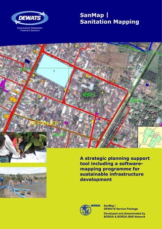
1. SanMap |
Sanitation Mapping
Decentralized Wastewater
Treatment Solutions
A strategic planning support
tool including a software-
mapping programme for
sustainable infrastructure
development
SanMap |
DEWATS Service Package
Developed and disseminated by
BORDA & BORDA BNS Network
2. Sanitation in urban areas – unplanned growth & a lack
of data restrict planned interventions
Barriers to urban planning The method of urban planning BORDA BNS Networks Mission
The realisation of sustainable urban In order to combat a city’s sanitation With a mission to improve the liveli-
development is one of today’s main issues in a comprehensive way, hoods of disadvantaged groups with-
challenges for local governments. urban planning should: in societies and to sustain the func-
Facing grave infrastructural prob- o identify the existing sanitation tioning of eco-systems through dis-
lems that occur from unplanned conditions through data collection semination of demand oriented Basic
growth of urban areas, local authori- & analysis Needs Services (BNS), BORDA
ties need a broad and integrated de- o highlight tag sources of pollution (Bremen Overseas Research and De-
velopment plan that allows planned (e.g. localization of unattended velopment Association) and its BNS
interventions. But planning and the septic tanks), priorities for inter- Partner Network develop and disse-
following interventions can’t be car- vention and appropriate solutions minate innovative solutions for facili-
ried out without the availability and in each area, accomplished with tating the access to BNS.
integration of current data from the the objective to apply a holistic
concerned area. Many local govern- approach for policy, strategic plan- DEWATS Service Packages
ments suffer from the inability to ning & implementation of a sanita- One Basic Needs Service is DEWATS,
act, caused by: tion programme an effective, efficient, affordable and
o the total lack of credenced specific o elaborating priority locations to proven wastewater treatment solu-
data (e.g. population density) propose centralized and decentra- tion for (sub-) tropical regions and
o out-dated data lized sanitation facilities low-income countries. DEWATS
o fragmented, decentralized data o provide verifiable indicators to stands for “Decentralized Wastewater
base assess the city government’s per- Treatment Solutions”, but it is much
o missing data digitalization formance in managing environ- more than just a technical approach.
o poor data standardization mental and public health issues DEWATS Service Packages include
o insufficient networking & coopera- not simply the construction of hard-
tion between different public “Cities and towns that are inclusive ware but a whole set of integrated
service departments and sustainable” are the vision of the measures which are combined accor-
o lack of information management UN ESCAP Sustainable Urban Deve- ding to demand. SanMap is one of
capacity lopment Unit (SUDU). To meet this these DEWATS Service Packages that
objective, the analysis and improve- aims to upgrade sanitation and
ment of sanitation conditions in cities wastewater treatment infrastructure
and towns by reliable databased in cities and towns by supporting the
planning is an urgent required action. creation of urban development plans
and subsequent interventions.
Most cities have large areas without basic sanitation,
wastewater treatment and with a high degree of
groundwater pollution and risks for public health.
Wastewater discharged from house-
holds and SME to the surface water,
as well as un-proper designed septic
tanks are a significant source of wa-
ter pollution. This urban problem can
only be solved if the locations of
wastewater generation and dis-
charge are known. The assessment
of qualified and quantified data, their
centralized availability, integration
and combination are basic pre-con-
ditions for all planning processes.
3. DEWATS SanMap: medium-term city planning for
sustainable infrastructure development
DEWATS Sanitation Mapping Key SanMap features o Transect walk
SanMap is a GIS based software In order to create a complex data- o Manual map plotting
mapping and simulation system in- base for planning interventions in the 5. Data Processing:
cluding additional methodical compo- target area, BORDA offers a demand- data digitalization, summarizing,
nents. This package allows local go- oriented San Map service that inclu- verification & converting
vernments to locate available infor- des the SanMap software, consulting 6. Stakeholder training &
mation systematically and to develop services and – according to demand producing a final report
a plan to upgrade sanitation and – collection, integration and analysis o reporting the final results
wastewater treatment infrastructure of data. For that purpose, the follow- o demand-oriented analysis &
in a comprehensive manner. ing steps are taken during SanMap recommendations
implementation: o software training
1. Framing SanMap:
o To define the responsible per- Citywide Mapping
sons in the local governments Before investing on getting detail on
from each public service depart- the sanitation situation in several
ment (working group) sub-districts, it is important to know
o To agree upon the area, where the sanitation conditions on a
specific sanitation mapping will citywide scale. Using available
be conducted secondary data from public authori-
o To clarify what data is available ties (Central Bureau of Statistic and
and what efforts are required to relevant local departments), a city
collect missing data & to process map (scale 1:25.000) is developed
BORDA experts & local authorities working
on an orthophoto arranged by SanMap that data accordingly by the SanMap software considering
software.
2. Presentations to stakeholders/local six different parameters. The para-
Depending on development priorities, government, informing them of meters are:
the mapping software supports va- the current situation and develop 1. Water supply
rious combinations of queries related ing a work plan, methodology & 2. Solid waste management
to the characteristics of target parameters of data collection 3. Slum areas
groups (e.g. health status, number of 3. Preparation of SanMap by: 4. Population density
children in families, average age, o checking the available data 5. Waterborne diseases
etc.), geographic specifications (e.g. o recruiting & training a field team 6. Socio-economic situation (e.g.
residential areas, industrial areas, o preparing target groups for field personal income)
communities located near river em- data collection These parameters can be combined
bankments, etc.) and economic 4. field data collection and unified by the SanMap software
status (low-, medium, high income). o Focus Group Discussions & inter- according to specific questions and
If reliable data is not available, parti- views (participatory assessment) queries. Additionally, consequences
cipatory assessments are categorized of changes and actions can be simu-
and quantified. lated with the aid of SanMap.
Different parameters can be highlighted and combined by the
SanMap-Software (left). – The SanMap programme is realized
within 6 implementation steps (below).
Training to
Stakeholder
Data & Final
Data Field Processing Report
Preparation Collection
Presentation
to of
Framing SanMap
Stakeholder
SanMap /LG
4. DEWATS SanMap – a flexible, efficient and high-level
urban infrastructure development approach
Sub-district Mapping Benefits of SanMap High-level solution
After getting an overview of the city- Coordinated by BORDA’s regional of- Today, BORDA and its BNS Partner
wide sanitation infrastructure, special fices and implemented with local Network have already assisted nu-
target areas like low-income settle- BORDA BNS Partner Organizations, merous municipal governments with
ments can be identified and focused SanMap provides multiple benefits: urban infrastructure development
on with sub-district mapping (scale o Systematic localisation of available planning. SanMap already supported
1:5.000). For this purpose, primary information and collection of the creation of urban development
data - direct data - are collected du- current data plans in India (e.g. Pune, Bangalore),
ring transect walks. Household sur- o Complex maps and simulations on Indonesia (e.g. Medan, Padang) and
veys, interviews with inhabitants, fo- different scales that visualize the Zambia (Lusaka).
cus group discussions, field cross (possible) conditions of the area By using SanMap, the need for and
checks and GeoCoding via GPS are o Ability to develop a plan for upgra- the installation of sanitation infra-
carried out. A sub-district map is ding of sanitation and wastewater structure can be visualized and simu-
created by the SanMap software treatment infrastructure lated. Local governments, munici-
using 30 different parameters, which o Calculation of investment costs & palities and finally the inhabitants
can be grouped into the following: support for funding assistance benefit from an elaborated planning
1. Topography o Courses of action and preparation tool towards solving these problems
2. Demography for the first steps towards impro- at the city planning level.
3. Water supply ving sanitation in specific neigh-
4. Health conditions bourhoods.
5. Sanitation infrastructure
6. Public sanitation facilities
7. Industry & sanitation
Through this process, the basis for
recommendations and courses of
action to improve the sanitation
infrastructure are created.
The participation of local authorities in
the SanMap planning process is a basic
component of the programme (left).
In cooperation with ESP/USAID, BORDA
implemented SanMap in
4 Indonesian cities: Medan, Padang,
Malang & Surabaya (right).
DEWATS Service Packages
o Treatment Systems o Emergency Sanitation o Health Impact Assessment &
o Community Based Sanitation o Sanitation for Prisons Hygiene Education
o School Based Sanitation o Sanitation for Real Estates o Capacity Development
o Sanitation for Hospitals & Hotels o Sanitation Mapping o Standardisation
o Wastewater Treatment for Agro-Industry o Municipal Sludge Treatment Plant o Research & Development
DEWATS – Decentralized Wastewater Treatment Solutions
Developed & disseminated by BORDA and over 20 BORDA BNS Network Partners in South and South East Asia & Southern Africa
With support from:
Bremen Overseas Research and Development Association 05SanMap_Okt2010_HBV3
BORDA Germany BORDA South East Asia BORDA South Asia BORDA SADC
Head Office Programme Office Programme Office India Programme Office
fon: + 49 - 421-137 18 Indonesia fon: + 91 - 80 41 52 75 54
e-mail: office@borda-net.org fon: + 62 - 274 88 82 73 e-mail: fon: + 255 – 22 2600 234
www.borda-net.org e-mail: yogya@borda-sea.org bangalore@borda-sa.org e-mail: dar@borda-sadc.org