

Recomendados
Mais conteúdo relacionado
Semelhante a ០៩ ខេត្តកោះកុង
Último
Último (20)
០៩ ខេត្តកោះកុង
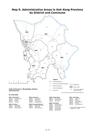
- 1. Map 9. Administrative Areas in Koh Kong Province by District and Commune 01 01 0905 0907 02 04 03 02 01 0904 03 03 03 02 06 02 04 0903 05 0903 01 03 05 01 0906 02 03 01 0902 02 02 0901 06 01 03 04 04 01 Legend 0 10 20 40 km National Boundary Provincial / Municipal Boundary Water Area District Boundary 0000 District Code Commune Boundary Code of Province / Municipality, District, 00 The last two digits of Coast Line and Commune Commune Code* * Commune Code consists of District Code and two digits. 09 KOH KONG 0901 Botum Sakor 0903 Kaoh Kong 0905 Mondol Seima 0907 Thma Bang 090101 Andaung Tuek 090301 Chrouy Pras 090501 Pak Khlang 090701 Ta Tey Leu 090102 Kandaol 090302 Kaoh Kapi 090502 Peam Krasaob 090702 Pralay 090103 Ta Noun 090303 Ta Tai Kraom 090503 Tuol Kokir 090703 Chumnoab 090104 Thma Sa 090304 Trapeang Rung 090704 Ruessei Chrum 0906 Srae Ambel 090705 Chi Phat 0902 Kiri Sakor 0904 Khemarak Phoumin 090601 Boeng Preav 090706 Thma Daun Pov 090201 Kaoh Sdach 090401 Smach Mean Chey 090602 Chi Kha Kraom 090202 Phnhi Meas 090402 Dang Tong 090603 Chi kha Leu 090203 Preaek Khsach 090403 Stueng Veaeng 090604 Chrouy Svay * Codes and boundaries are as of 090605 Dang Peaeng September 7, 2009. 090606 Srae Ambel II - 11