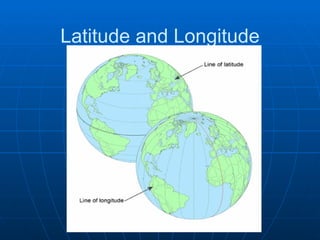
Latitude and longitude lines form a grid system that can be used to identify locations on Earth. Latitude lines run east-west and are parallel to the equator, ranging from 0 degrees at the equator to 90 degrees at the North and South Poles. Longitude lines run north-south and intersect at the poles, ranging from 0 degrees at the prime meridian to 180 degrees on the opposite side of the globe. To locate a position, the latitude is given first, followed by the longitude.
![Latitude and Longitude ,[object Object],[object Object]](data:image/gif;base64,R0lGODlhAQABAIAAAAAAAP///yH5BAEAAAAALAAAAAABAAEAAAIBRAA7)