SlideShare uma empresa Scribd logo
1 de 12
Supporting spatial negotiations in land use planning Gustavo Arciniegas, Ron Janssen
Outline ,[object Object],[object Object],[object Object],[object Object],[object Object]
1. MCA for evaluation and ranking of alternatives
1. MCA for ranking of alternatives
1. MCA for negotiation support
2. The Bodegraven polder ,[object Object],[object Object],[object Object]
3. Negotiation workshop ,[object Object],[object Object]
3. Tool at work: start situation Intensive agriculture Nature
3. Tool at work: feedback on parcels
3. Tool at work: land use is exchanged Nature Intensive agriculture
4. Results of negotiations
5. Conclusions ,[object Object],[object Object],[object Object],[object Object]

Mais conteúdo relacionado

Destaque

Destaque (9)

EXPOSICIÓN nº 4
EXPOSICIÓN nº 4EXPOSICIÓN nº 4
EXPOSICIÓN nº 4
 
Criminalistica
Criminalistica Criminalistica
Criminalistica
 
Untitled 2
Untitled 2Untitled 2
Untitled 2
 
AAHAM_CharityCare_BadDebt
AAHAM_CharityCare_BadDebtAAHAM_CharityCare_BadDebt
AAHAM_CharityCare_BadDebt
 
Mentoring week 2
Mentoring week 2Mentoring week 2
Mentoring week 2
 
Australia And New Zealand
Australia And New ZealandAustralia And New Zealand
Australia And New Zealand
 
Stock Market Game
Stock Market GameStock Market Game
Stock Market Game
 
Assignment2 solution fragment
Assignment2 solution fragmentAssignment2 solution fragment
Assignment2 solution fragment
 
Skolebibliotek 220310
Skolebibliotek 220310Skolebibliotek 220310
Skolebibliotek 220310
 

Mais de GISRUK conference

7B_3_Matterhorn on the horizon
7B_3_Matterhorn on the horizon7B_3_Matterhorn on the horizon
7B_3_Matterhorn on the horizonGISRUK conference
 
7B_2_Topological consistent generalization of openstreetmap
7B_2_Topological consistent generalization of openstreetmap7B_2_Topological consistent generalization of openstreetmap
7B_2_Topological consistent generalization of openstreetmapGISRUK conference
 
7A_4_Gps data collection setting for pedestrian activity modelling
7A_4_Gps data collection setting for pedestrian activity modelling7A_4_Gps data collection setting for pedestrian activity modelling
7A_4_Gps data collection setting for pedestrian activity modellingGISRUK conference
 
5A_3_GIS based spatial modelling for improving the sustainability of aggregat...
5A_3_GIS based spatial modelling for improving the sustainability of aggregat...5A_3_GIS based spatial modelling for improving the sustainability of aggregat...
5A_3_GIS based spatial modelling for improving the sustainability of aggregat...GISRUK conference
 
5A_1_Land evaluation techniques comparing fuzzy ahp with ideal point methods
5A_1_Land evaluation techniques comparing fuzzy ahp with ideal point methods5A_1_Land evaluation techniques comparing fuzzy ahp with ideal point methods
5A_1_Land evaluation techniques comparing fuzzy ahp with ideal point methodsGISRUK conference
 
4B_3_Automatically generating keywods for georeferenced imaged
4B_3_Automatically generating keywods for georeferenced imaged4B_3_Automatically generating keywods for georeferenced imaged
4B_3_Automatically generating keywods for georeferenced imagedGISRUK conference
 
4B_1_How many volunteers does it take to map an area well
4B_1_How many volunteers does it take to map an area well4B_1_How many volunteers does it take to map an area well
4B_1_How many volunteers does it take to map an area wellGISRUK conference
 
4A_1_Uncertainty in the 2001 output area classification for the census of eng...
4A_1_Uncertainty in the 2001 output area classification for the census of eng...4A_1_Uncertainty in the 2001 output area classification for the census of eng...
4A_1_Uncertainty in the 2001 output area classification for the census of eng...GISRUK conference
 
3A_4_Applying network analysis to quantify accessibility to urban greenspace ...
3A_4_Applying network analysis to quantify accessibility to urban greenspace ...3A_4_Applying network analysis to quantify accessibility to urban greenspace ...
3A_4_Applying network analysis to quantify accessibility to urban greenspace ...GISRUK conference
 
3A_2_Modelling health-harming behaviours in a socially ranked geographic space
3A_2_Modelling health-harming behaviours in a socially ranked geographic space3A_2_Modelling health-harming behaviours in a socially ranked geographic space
3A_2_Modelling health-harming behaviours in a socially ranked geographic spaceGISRUK conference
 
1A_3_A geodemographic classification of london primary schools
1A_3_A geodemographic classification of london primary schools1A_3_A geodemographic classification of london primary schools
1A_3_A geodemographic classification of london primary schoolsGISRUK conference
 
UK Map Challenge Aidan Slingsby
UK Map Challenge   Aidan SlingsbyUK Map Challenge   Aidan Slingsby
UK Map Challenge Aidan SlingsbyGISRUK conference
 
SP_3 Automatic identification of high streets and classification of urban lan...
SP_3 Automatic identification of high streets and classification of urban lan...SP_3 Automatic identification of high streets and classification of urban lan...
SP_3 Automatic identification of high streets and classification of urban lan...GISRUK conference
 
9B_1_Trust in web gis a preliminary investigation of the environment agencys ...
9B_1_Trust in web gis a preliminary investigation of the environment agencys ...9B_1_Trust in web gis a preliminary investigation of the environment agencys ...
9B_1_Trust in web gis a preliminary investigation of the environment agencys ...GISRUK conference
 
9A_2_Automatic classification of retail spaces from a large scale topographc ...
9A_2_Automatic classification of retail spaces from a large scale topographc ...9A_2_Automatic classification of retail spaces from a large scale topographc ...
9A_2_Automatic classification of retail spaces from a large scale topographc ...GISRUK conference
 
9A_1_On automatic mapping of environmental data using adaptive general regres...
9A_1_On automatic mapping of environmental data using adaptive general regres...9A_1_On automatic mapping of environmental data using adaptive general regres...
9A_1_On automatic mapping of environmental data using adaptive general regres...GISRUK conference
 
8B_4_Exploring the usability of geographic information
8B_4_Exploring the usability of geographic information8B_4_Exploring the usability of geographic information
8B_4_Exploring the usability of geographic informationGISRUK conference
 
8B_2_Using sound to represent uncertainty in address locations
8B_2_Using sound to represent uncertainty in address locations8B_2_Using sound to represent uncertainty in address locations
8B_2_Using sound to represent uncertainty in address locationsGISRUK conference
 
8B_1_A map to hear - use of sound in enhancing the map use experience
8B_1_A map to hear - use of sound in enhancing the map use experience8B_1_A map to hear - use of sound in enhancing the map use experience
8B_1_A map to hear - use of sound in enhancing the map use experienceGISRUK conference
 

Mais de GISRUK conference (20)

8A_1_To vote or not to vote
8A_1_To vote or not to vote8A_1_To vote or not to vote
8A_1_To vote or not to vote
 
7B_3_Matterhorn on the horizon
7B_3_Matterhorn on the horizon7B_3_Matterhorn on the horizon
7B_3_Matterhorn on the horizon
 
7B_2_Topological consistent generalization of openstreetmap
7B_2_Topological consistent generalization of openstreetmap7B_2_Topological consistent generalization of openstreetmap
7B_2_Topological consistent generalization of openstreetmap
 
7A_4_Gps data collection setting for pedestrian activity modelling
7A_4_Gps data collection setting for pedestrian activity modelling7A_4_Gps data collection setting for pedestrian activity modelling
7A_4_Gps data collection setting for pedestrian activity modelling
 
5A_3_GIS based spatial modelling for improving the sustainability of aggregat...
5A_3_GIS based spatial modelling for improving the sustainability of aggregat...5A_3_GIS based spatial modelling for improving the sustainability of aggregat...
5A_3_GIS based spatial modelling for improving the sustainability of aggregat...
 
5A_1_Land evaluation techniques comparing fuzzy ahp with ideal point methods
5A_1_Land evaluation techniques comparing fuzzy ahp with ideal point methods5A_1_Land evaluation techniques comparing fuzzy ahp with ideal point methods
5A_1_Land evaluation techniques comparing fuzzy ahp with ideal point methods
 
4B_3_Automatically generating keywods for georeferenced imaged
4B_3_Automatically generating keywods for georeferenced imaged4B_3_Automatically generating keywods for georeferenced imaged
4B_3_Automatically generating keywods for georeferenced imaged
 
4B_1_How many volunteers does it take to map an area well
4B_1_How many volunteers does it take to map an area well4B_1_How many volunteers does it take to map an area well
4B_1_How many volunteers does it take to map an area well
 
4A_1_Uncertainty in the 2001 output area classification for the census of eng...
4A_1_Uncertainty in the 2001 output area classification for the census of eng...4A_1_Uncertainty in the 2001 output area classification for the census of eng...
4A_1_Uncertainty in the 2001 output area classification for the census of eng...
 
3A_4_Applying network analysis to quantify accessibility to urban greenspace ...
3A_4_Applying network analysis to quantify accessibility to urban greenspace ...3A_4_Applying network analysis to quantify accessibility to urban greenspace ...
3A_4_Applying network analysis to quantify accessibility to urban greenspace ...
 
3A_2_Modelling health-harming behaviours in a socially ranked geographic space
3A_2_Modelling health-harming behaviours in a socially ranked geographic space3A_2_Modelling health-harming behaviours in a socially ranked geographic space
3A_2_Modelling health-harming behaviours in a socially ranked geographic space
 
1A_3_A geodemographic classification of london primary schools
1A_3_A geodemographic classification of london primary schools1A_3_A geodemographic classification of london primary schools
1A_3_A geodemographic classification of london primary schools
 
UK Map Challenge Aidan Slingsby
UK Map Challenge   Aidan SlingsbyUK Map Challenge   Aidan Slingsby
UK Map Challenge Aidan Slingsby
 
SP_3 Automatic identification of high streets and classification of urban lan...
SP_3 Automatic identification of high streets and classification of urban lan...SP_3 Automatic identification of high streets and classification of urban lan...
SP_3 Automatic identification of high streets and classification of urban lan...
 
9B_1_Trust in web gis a preliminary investigation of the environment agencys ...
9B_1_Trust in web gis a preliminary investigation of the environment agencys ...9B_1_Trust in web gis a preliminary investigation of the environment agencys ...
9B_1_Trust in web gis a preliminary investigation of the environment agencys ...
 
9A_2_Automatic classification of retail spaces from a large scale topographc ...
9A_2_Automatic classification of retail spaces from a large scale topographc ...9A_2_Automatic classification of retail spaces from a large scale topographc ...
9A_2_Automatic classification of retail spaces from a large scale topographc ...
 
9A_1_On automatic mapping of environmental data using adaptive general regres...
9A_1_On automatic mapping of environmental data using adaptive general regres...9A_1_On automatic mapping of environmental data using adaptive general regres...
9A_1_On automatic mapping of environmental data using adaptive general regres...
 
8B_4_Exploring the usability of geographic information
8B_4_Exploring the usability of geographic information8B_4_Exploring the usability of geographic information
8B_4_Exploring the usability of geographic information
 
8B_2_Using sound to represent uncertainty in address locations
8B_2_Using sound to represent uncertainty in address locations8B_2_Using sound to represent uncertainty in address locations
8B_2_Using sound to represent uncertainty in address locations
 
8B_1_A map to hear - use of sound in enhancing the map use experience
8B_1_A map to hear - use of sound in enhancing the map use experience8B_1_A map to hear - use of sound in enhancing the map use experience
8B_1_A map to hear - use of sound in enhancing the map use experience
 

SP_4 Supporting spatial negotiations in land use planning
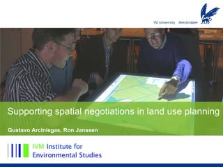