SlideShare uma empresa Scribd logo
1 de 10
CORDILLERA ADMINISTRATIVE REGION

        The Cordillera Administrative Region (CAR) is a region in the Philippines composed of
the provinces of Abra, Apayao, Benguet, Ifugao, Kalinga and Mountain Province, as well as Baguio City,
the regional center. The Cordillera Administrative Region encompasses most of the areas within
the Cordillera Central mountains of Luzon, the largest mountain range in the country. It is the country's
only land-locked region. The region is home to numerous indigenous tribes collectively called the Igorot.

CAR Provinces and Population

CAR is subdivided into 6 provinces and one chartered city, Baguio.

Province/City         Capital      Population Area     Pop.
                                   (2007)     (km²)    density
                                                       (per km²)


  Abra                Bangued      230,953    3,975.6 58.1


  Apayao              Kabugao      103,633    3,927.9 26.4


  Benguet             La           372,533    2,599.4 143.3
                      Trinidad


  Ifugao              Lagawe       180,711    2,517.8 71.8


  Kalinga             Tabuk        182,326    3,119.7 58.4
                      City


  Mountain            Bontoc       148,661    2,097.3 70.9                   Political map of Cordillera
  Province                                                                    Administrative Region


  Baguio City         —            301,926    57.5     5,250.9


Economy

Cordillera has abundant mineral reserves. These include metallic ores such as gold, copper, silver, zinc,
and non-metallic minerals like sand, gravel and sulfur. Mineral reserves are found in all the provinces.
However, mining is concentrated in Benguet.
Baguio City and La Trinidad, Benguet are considered as the industrial centers in the region due. In
Baguio, you will find an Export Processing Zone where operations of big companies like Texas
Instruments, and MOOG are located. In La Trinidad you will find the Provincial Capitol and regional
branches of government organizations.
Tourist attractions

Tourist attractions in the region include the world-famous Banaue Rice Terraces in the province
of Ifugao. Nations around the world boast of their own self-proclaimed "eighth wonder of the world."
The Philippines considers Banaue Rice Terraces as its "Eighth Wonder of the World." The Banaue
terraces, ancient sprawling man-made structures from 2,000 to 6,000 years old, are a UNESCO World
Heritage Site. They are part of the Rice Terraces of the Philippine Cordilleras, widely found in the
provinces of Apayao, Benguet, Ifugao, Kalinga, and Mountain Province.
Natural attractions of the region include the Sumaguing Cave in Sagada and the mummy caves
of Benguet and Mt. Province. There are four National Parks: Cassamata Hill, Mount Pulag, the highest
mountain in Luzon, and second highest mountain in the Philippines, following Mount Apo of Davao, with
an elevation of 2,922 meters above mean sea level, Mt. Data, and Balbalasang-Balbalan, located in the
province of Kalinga. Kalinga also offers world-class white water rafting along the Chico River. The
summer capital of the Philippines is Baguio, within the Cordillera Administrative Region.


The Banaue Rice Terraces (Tagalog: Hagdan-hagdang Palayan ng Banawe) also called Payew, are 2000-
year old terraces that were carved into the mountains of Ifugao in the Philippines by ancestors of the
indigenous people. The Rice Terraces are commonly referred to by Filipinos as the "Eighth Wonder of
the World". It is commonly thought that the terraces were built with minimal equipment, largely by
hand. The terraces are located approximately 1500 meters (5000 ft) above sea level and cover 10,360
square kilometers (about 4000 square miles) of mountainside. They are fed by an
ancient irrigation system from the rainforests above the terraces. It is said that if the steps are put end
to end it would encircle half the globe.

Culture

The Cordillera region is known for its unique musical instruments including the gangsa kalinga, nose
flute, bamboo flute, buzzer, bangibang, tongatong, diwdiw-as, saggeypo, and bamboo zither.
The region also has various festivals. They include:
Panagbenga / Baguio Flower Festival which is celebrated in February. The festival focuses on Baguio as
the Flower Garden City of the North. Highlights include flower exhibits, lectures, garden tours, floral
competition and a parade of floats.
Adivay festival in Benguet which means "coming together of people to celebrate" is celebrated every
month of November. The month-long activities highlights the Agro-industrial and trade fair which
showcase the different products of Benguet.
Ullalim Festival/ in Kalinga which is celebrated every February 14. It is in celebration of the founding
anniversary of the province and the Peace acts calledBodong. It is the poetic expression of the heroic
exploits, romance, joys, successes as well as tribulations, and the way of life of the Kalingas from birth to
death. The Festival highlights the weaved clothes (laga) exhibits, world class coffee beans and other
products of Kalinga.
LANG-AY Festival in Mountain Province celebrated every April 7. This is a week-long agro-industrial
trade, tourism and cultural fair with tribal dances and songs. Lang-ay is a native term which describes
the tradition of the people of Mountain Province to celebrate festivities, share happiness, foster family
solidarity, hospitality and nurture friendship - all with a toast of home-brewed wine.
Banaue Imbayah festival which is celebrated every 4 years. It is a three-day festival from December 5 to
8 consisting of a parade portraying the evolution of the Ifugao culture followed by ethnic games.
Tabuk Matagoan Festival which features G-String marathon (runners wear G-String only), cultural
dances and songs. The festival showcases the different products of tabuk coming from the different
parts of Kalinga such as the aromatic Kalinga coffee.
                                             Abra (province)


Abra is a landlocked province of the Philippines in the Cordillera Administrative Region in Luzon. Its
capital is Bangued, and it borders Ilocos Norteand Apayao on the north, Ilocos Sur and Mountain
Province on the south, Ilocos Norte and Ilocos Sur on the west, and Kalinga, and Apayao on the east.

Demographics

Abra's inhabitants are mostly descendants of Ilocano settlers and members of the Tingguian tribe. As of
2007, the population of the province is 230,953.
The predominant languages are Ilocano and Itneg. Based on the 2000 census survey, the majority of the
province population is Ilocano 71.9%. Other ethnic groups living in the province are
the Tinguian 18.7%, Ibanag 4.5%, Isneg 3.2% and Tagalog 0.4%.
History

The first inhabitants of Abra were the ancestors of the Bontocs and the Ifugaos. These inhabitants
eventually left to settle in the old Mountain Province. Other early inhabitants were the Tingguians, or
Itnegs, as they are also known. The Ilocos came to trade with the tinguians but eventually they saw the
province to be very good so they invaded and the tinguians were forced to go to the mountains.
In 1598 a Spanish garrison was established in Bangued to protect the Ilocanos who converted to
Christianity from Tingguian raids. During the British Occupation of the Philippines, Gabriela Silang and
her army fled to Abra from Ilocos and continued the revolt begun by her slain husband, Diego Silang.
She was captured and hung by the Spanish in 1763.
In 1818 the Ilocos region, including Abra, was divided into Ilocos Norte and Ilocos Sur. In 1846 Abra was
created[4] as a political-military province with Lepanto as a sub-province. It remained so until the arrival
of the Americans in 1899.
In 1908 the Philippine Commission once again in annexed Abra to Ilocos Sur in an attempt to resolve
Abra's financial difficulties. But on March 9, 1917, the Philippine Assembly re-established Abra as a
province.
In 1942, the Japanese forces occupied the Philippines and entered Abra.
In 1945, the liberation in Abra in Northern Luzon by the Philippine Commonwealth forces and the local
Cordilleran guerrillas against the Japanese during the Battle of Abra at the end the Second World War.
The revolutionary Marxist priest, Conrado Balweg, who fought for the rights of the Cordillera tribes,
began his crusade in Abra. After successfully negotiating a peace accord with Balweg's group in 1987,
the Philippine government created the Cordillera Administrative Region, which includes Abra.
Physical
Abra is hemmed in by the towering mountain ranges of the Ilocos in the west and the Cordillera Central
in the east. It has an extremely rugged terrain, with mountains and hills rising along its perimeter and
interior. The plains are drained by the Abra River, which flows northward from Mt. Data in the Mountain
Province.
Economy

As of 1990, there were 743 cottage industries in Abra, of which 208 are registered with the Department
of Trade and Industry. 59% are engaged in bamboo and rattan craft making, both leading industries in
the area.
In 1992, the natural dye industry, together with loom weaving and embroidery, was revived by former
Governor Ma. Zita Claustro-Valera, the first woman governor of Abra.
Abra's economy is agriculture-based. Its major crops are rice, corn, and root crops; and commercial
produce are coffee, tobacco, and coconut. Extensive grassland and pasture areas are used for livestock
production.
                                                Apayao


         Apayao is a landlocked province of the Philippines in the Cordillera Administrative
Region in Luzon. Its administrative capital is Luna and founding capital Kabugao. It borders Cagayan to
the north and east, Abra and Ilocos Norte to the west, and Kalinga to the south. Prior to 1995, Kalinga
and Apayao comprised a single province named Kalinga-Apayao, until they were split into two to better
service the needs of individual native tribes in the provinces.

Economy

Apayao is devoted to agricultural production, particularly food and industrial crops such as palay, corn,
coffee, root crops and vegetables. Main fruits produce are lanzones, citrus, bananas and pineapples.
Rice production totals 42,602 metric tons annually, as food crops totals 96,542 metric tons.
Economic activity is also based on livestock and poultry breeding such as swine, carabao, cattle, goat
and sheep. Other additional investment includes manufacturing, food processing, furniture, crafts and
house wares making.
History

Although Apayao was among the earliest areas penetrated by the Spaniards in the Cordilleras, the
region, inhabited by the Isneg tribe, remained largely outside Spanish control until late in the 19th
century. As early as 1610, the Dominican friars established a mission in what is now the town ofPudtol.
In 1684, the friars again made vain attempts to convert the people and established a church in what is
now Kabugao. The ruins of the early churches in Pudtol and Kabugao still stand as mute testimony to the
failed attempts to occupy Apayao.
The Spanish authorities were then able to establish the comandancias of Apayao and Cabugaoan in
1891, which covered the western and eastern portions of what is now Apayao. The comandancias,
however, failed to bring total control and the Spanish government only maintained a loose hold over the
area.
The Americans established the Mountain Province on August 13, 1908, with the enactment of Act No.
1876. Apayao, along with Amburayan,Benguet, Bontoc, Ifugao, Kalinga, and Lepanto, became sub-
provinces of this new province. Before this, Apayao had been a part of Cagayanprovince.
In 1942, Japanese Imperial forces entered Apayao, starting a three-year occupation of the province
during the Second World War. Local Filipino troops of the 1st, 2nd, 12th, 15th and 16th Infantry Division
of the Philippine Commonwealth Army and the military forces of the USAFIP-NL 11th and 66th Infantry
Regiment, supported by the Cordilleran guerrillas, drove out the Japanese in 1945.
After almost 60 years, on June 18, 1966, the huge Mountain Province was split into four provinces with
the enactment of Republic Act No. 4695. The four provinces were Benguet, Bontoc (renamed Mountain
Province), Kalinga-Apayao and Ifugao. Kalinga-Apayao, along with Ifugao, became one of the provinces
of the Cagayan Valley region in 1972.
On July 15, 1987, the Cordillera Administrative Region was established and Kalinga-Apayao was made
one of its provinces. Finally, on February 14, 1995, Kalinga-Apayao was split into two distinct provinces
with the passage of Republic Act No. 7878.
The merged outlines of Apayao and Kalinga resemble a bust of a man akin to former
President Ferdinand Marcos (looking toward his home province,Ilocos Norte) whom the media called as
the "Great Profile" during the Marcos Era.
Demographics

Based on the 2000 census survey, half of the population is Ilocano 50.82% and almost 1/3 of the
population    is Isnag 29.95%.  Other      ethnic     groups    living   in   the   province   are
the Malaueg 3.69%, Isneg3.48%, Kalinga 3.08%, Ibaloi 1.01%, Kankana-ey 1.24% and Bontok 1.04%.

                                               Benguet
               ɡet]
Benguet [beŋˈ is a landlocked province of the Philippines in the Cordillera Administrative
Region in Luzon. Its capital is La Trinidad and borders, clockwise from the south, Pangasinan, La
Union, Ilocos Sur, Mountain Province, Ifugao, and Nueva Vizcaya.
Baguio, a popular tourist destination in the country, is located in the interior of the province, however,
the city is independent of the province.
Demographics
        Based on the May 2000 census, Benguet has a total population of 330,129, which makes it the
most populous province in the region. This figure is up by 16,296 from 313,833 persons recorded in the
1995 census, giving an annual growth rate of 1.09% during the 5-year period—much, much lower than
the national average of 2.43%. If this growth rate were maintained, Benguet would double its
population in approximately 64 years.
The province registered at 63,123 households, an increase of 4,588 households over the 1990 figure.
This gave an average household size of 5.2 persons, a little higher than the national average of 4.99.
Benguet is the homeland of several tribes, collectively referred to as the Igorot. Two of them,
the Ibaloi in the southeast and the Kankana-ey in the northwest, are the dominant tribes of Benguet. In
the 2000 census, 43% of the household population were Kankana-ey. About 29.2% were Ibaloi and
13.4% were Ilocano. Other ethnic groups included Ikalahan (3.7%) and Tagalog (2.4%).
Languages
Most of the tribes in Benguet have their own languages. The Ibaloi tribe speak Ibaloy, which is similar
to Pangasinan. The Kankana-ey tribe speak have their own language, which is related to the Bontoc
language. Many inhabitants also speak Ilocano, Tagalog, and English for trade and commerce.
Economy

Agriculture, mining, and tourism are the major industries in Benguet. Because of its temperate climate
and high altitude, Benguet is an ideal place for producing vegetables. Benguet is often called the Salad
Bowl of the Philippines. During February 2007, Benguet suffered crop damage due to freezing
temperatures in the area, reaching as low as 5 Celsius and even lower in some areas, and important
crops      like      cabbages      were     damaged.       Major     crops      include potatoes, Baguio
beans, peas, strawberries, cabbage, lettuce,    and carrots.   Other    agricultural-related    activities
are monggoprocessing, fruit preservation, peanut brittle manufacturing, broom making, basket weaving,
and flower growing. Apisang (scientific name: Pittosporum resiniferum), a plant endemic to the
Philippines, is also being grown in Kapangan and Kibungan towns as a potential alternative source of fuel
and energy, rivaling the overhyped jatropha biofuel plant.
Mining is another major industry of Benguet, which is one of the country's leading gold producers.
The Benguet Corporation one of the Philippines largest diversified conglomerates was founded to
exploit mines in Benguet Province. Other mineral deposits are silver, copper, pyrite,
and limestone. Silversmithing is a large industry in Benguet, and many entrepreneurs sell silver works at
lower prices in Baguio City, compared to Manila. In 2006 alone revenues from mining reached a
stunning four billion pesos, and yet this figure comes from just two-Lepanto Consolidated Mining
Corporation and Philex Mines- of the many mining firms operating in the province. Nevertheless, the
province's mining vigor has never translated into better quality of life of the Benguet people, simply
because a bulk of the mining firm's taxes are not paid directly to the province. The two mining
corporations, like many others around the country, have principal offices in the City of Makati, a set-up
that makes Makati the prime mining tax beneficiary.
The presence of Baguio City in Benguet draws a large number of tourists from the lowlands. Often,
people who go to Baguio also explore the province, especially the strawberry and vegetable plantations
in La Trinidad.


                                                 Ifugao
Ifugao is a landlocked province of the Philippines in the Cordillera Administrative Region in Luzon.
Covering a total land area of 262,820 hectares, the province of Ifugao is located in a mountainous region
characterized by rugged terrain, river valleys, and massive forests. Its capital is Lagaweand
borders Benguet to the west, Mountain Province to the north, Isabela to the east, and Nueva Vizcaya to
the south.
It is named after the term "i-pugo" which means "i" (from/people) and "pugo" (hill), thus people of the
hill.
The Rice Terraces of the Philippine Cordilleras and Banaue Rice Terraces are the main tourist attractions
in the province. These 2000-year-old terraces were carved into the mountains, without the aid
of machinery, to provide level steps where the natives can plant rice. In 1995, they were declared
a UNESCO World Heritage Site.
Mountain tribes in Northern Luzon

Traveling to the northern part of the island Luzon will bring you not only to beautiful landscapes with
amazing rice terraces. It will bring you also to the regions with remote villages and colorful and
traditional living upland tribal communities. Their ancestors constructed the fascinating rice terraces
with the perfect working irrigation systems. These mountain tribes still distinguish themselves by their
specific cultural expression and their skills.
They have skills in making bowls, baskets, weapons and clothing. It was the Ifugao people who built up
the rice terraces. They are still living and working as in the past.
In the past the Ifugao were feared head-hunters, just as other tribes in the mountainous regions of
northern Luzon. The war-dance (the bangibang) is one of the cultural remnants of the time of tribal
conflict.
This dance is traditionally held on the walls of the rice terraces by the men, equipped with spears, axes
and wooden shields and a headdress made of leaves.
People and culture

The People of Ifugao are not called "IGOROTS" but are called IFUGAOS. Ifugaos are different from any
other tribe in the cordilleras ranging from culture, tradition, language, and idealism. There have been no
Ifugao beggar recorded in history. Some neighboring tribes of the Ifugaos tries to annex or connects
themselves with Ifugao so as to share fame the ifugao people are experiencing.
Rice culture
Ifugao culture revolves around the rice, which is considered a prestige crop. There is an elaborate and
complex array of rice culture feasts inextricably linked with taboos and intricate agricultural rites, from
rice cultivation to rice consumption. Harvest season calls for grandiose thanksgiving feasts, while the
concluding harvest rites "tungo" or "tungul" (the day of rest) entail a strict taboo of any agricultural
work. Partaking of the rice wine (bayah), rice cakes, and moma (mixture of several herbs, powdered
snail shell and betel nut/ arecoline: and acts as a chewing gum to the ifugaos) is an indelible practice
during the festivities and ritual activities.
Kalinga
        Kalinga (Tagalog pronunciation: [kɐˈ    liŋɐ]) is a landlocked province of the Philippines in
the Cordillera Administrative Region in Luzon. Its capital isTabuk and borders Mountain Province to the
south, Abra to the west, Isabela to the east, Cagayan to the northeast, and Apayao to the north. Prior
to 1995, Kalinga and Apayao used to be a single province named Kalinga-Apayao, until they were split
into two to better service the needs of individual native tribes in the provinces.

Geography

Political
Kalinga is subdivided into 1 city and 7 municipalities. Tabuk was proclaimed a component city in 2007,
but in November 2008 the Supreme Court of the Philippines ruled that its cityhood was
unconstitutional. However, Tabuk had its city status reinstated by the Supreme Court on December 22,
2009.
City

 Tabuk
Municipalities

      Balbalan      Rizal (Liwan)
      Lubuagan      Tanudan
      Pasil         Tinglayan
      Pinukpuk

The topography of Kalinga province is rugged and sloping with mountain peaks ranging from 1,500 to
2,500 meters in height. The province’s geographic feature on the western portion is characterized by
sharp crested interlinking peaks of steep slopes, isolated flatlands, plateaus and valleys. The eastern
portion is generally rolling and gradually sloping foothills.
The province is drained mainly by the Chico River with headwater originating from Mt. Province and
empties into the Cagayan River.The Chico River has several tributaries: Bunog River in Tinglayan in the
south, the Tanudan and Biga Rivers in the east, Pasil River in the middle, Mabaca and Saltan Rivers in the
north. Several small lakes can also be found in Kalinga. These water resources if to be tapped could
provide abundant sources for power generation, fishing, irrigation and for domestic use, but would
destroy rice terraces, villages, livelihoods, and complete indigenous cultures.
The province enjoys an average temperature ranging from 17 to 22 degrees Celsius and Type 3 weather
patterns. The dry season extends from November to April. The rest of the year is considered rainy. The
heaviest rains usually occur in the months of July to October.
Large portion of the lower regions of the province are open grassland suitable for pasture, but the
highlands have extensive areas of tropical rainforest and at higher elevation in the west, pine. Rizal and
Tabuk with their flatlands are the biggest rice producers. Next in rice production are the mountainous
areas – the rice terraces of Balbalan, Lubuagan, Pasil, Pinukpuk, Tinglayan, and Tanudan.
Culture

There are many sub tribes in the province. The strong sense of tribal membership and filial loyalty
results in frequent tribal unrest and occasional outright war. Due to the mountainous terrain and
warrior-culture of the people, the Kalingas were able to maintain their culture despite the attempted
occupation of the Spaniards, Japanese, and Americans. Unknown to many, the last stand of President
Emilio Aguinaldo (First President of the Philippines) was in this province, in Lubuagan, which he
proclaimed the national capital, and where the Aguinaldo museum commemorates him and those
events.
The people of Kalinga are the most extensive rice farmers of the Cordillera peoples, having been blessed
with some of the most suitable land for both wet and dry rice farming. Like the Ifugaos, the Kalingas are
one of the extensive terrace builders in the country. The Kalingas are also skilled potters with pot
making concentrated in the lower Chico River Valley. They are also excellent in basket and loom weaving
and metal works.
Demographics

       Based on the 2000 census survey, 64.4% of the population are Kalinga and Ilocanos are 24% of
the province population. Other ethnic groups living in the province are the Kankana-
ey 2.5%, Ibontoc 1.6%, Tagalog 1.3% and Applai 1%.

                                        Mountain Province
Mountain Province (Filipino:Lalawigang Bulubundukin) is a landlocked province of the Philippines in
the Cordillera Administrative Region in Luzon. Its capital is Bontoc and borders, clockwise from the
south, Ifugao, Benguet, Ilocos Sur, Abra, Kalinga, and Isabela.
Mountain Province is sometimes incorrectly named Mountain in some foreign references. The name is
also incorrectly shortened by locals to Mt. Province, which in turn is read by native Anglophones as
"Mount Province". The province was named so for being in the Cordillera Central mountain range found
in the upper realms of Luzon island.
Mountain Province was also the name of the historical province that included most of the current
Cordillera provinces. This old province was established by the Americans in 1908 and was later split in
1966 into Mountain Province, Benguet, Kalinga, Apayao and Ifugao. Mountain province is known for its
Mummy caves which contain naturally mummified bodies which probably became so due to the humid
atmosphere. The hanging Coffins are also found in the province, these are literally coffins hanging on to
the branches of trees, many tourists claim there is no foul odor, the bodies were probably mummified
by the atmosphere according to theory.
Demographics

Based on the 2000 census survey, 52% of the population are Kankana-ey. Other ethnic groups living in
the province are the Balangao 13.6%, Ibontoc12%, and other ethnicity compromise about 21.6% of the
province's population.[1]

                                                Baguio
         The City of Baguio (Ilokano: Ciudad ti Baguio; Filipino: Lungsod ng Baguio) is a highly urbanized
city in northern Luzon in the Philippines. Baguio City was established by Americans in 1900 at the site of
an Ibaloi village known as Kafagway. Baguio City was designated by the Philippine Commission as the
Summer Capital of the Philippines on June 1, 1903 and incorporated as a city by the Philippine
Assembly on September 1, 1909. Baguio is the seat of government of the Cordillera Administrative
Region. The name of the city is derived from the word bagiw in Ibaloi, the indigenous language of the
Benguet Region, meaning 'moss'. The city is at an altitude of approximately 1500 meters (5100 ft) in
the Luzon tropical pine forests ecoregion conducive to the growth of mossy plants and orchids. Baguio
City has become the center of business and commerce as well as the center of education in the entire
Northern Luzon.

History

The region around Baguio was first settled primarily by the Ibaloi's and the kankanaey's. In the nearby
town of La Trinidad, Benguet, Spaniards established a commandante or military garrison, although
Kafagway, as Baguio was once known, was barely touched. In 1901 Japanese and Filipino workers hired
by the Americans built Kennon Road, the first road directly connecting Kafagway with the lowlands of
Pangasinan. Before this, the only road to Kafagway was Naguilian Road. On September 1, 1909 Baguio
was declared a chartered city. The famous American architect Daniel Burnham, one of the earliest
successful modern city planners, laid a meticulous plan for the city in 1904. His plan was, nevertheless,
realized only to a small extent, primarily due to growth of the city well beyond its initial planned
population of 25,000 people. The Americans earlier declared Baguio the Summer Capital of the
Philippines on July 1, 1903 and The American Residence as the residence of the American governor-
general to escape Manila's summer heat. They further developed Baguio, building parks and public
structures such as Wright Park in honor of Governor General Luke E. Wright,Burnham Park in honor of
Baguio city planner Daniel Burnham, Governor Pack Road, and Session Road.


                                                              Burnham Park is an urban park
                                                              located at the heart of the City of
                                                              Baguio, in the Philippines. It was
                                                              named after the American architect and
                                                              urban      planner, Daniel     Hudson
                                                              Burnham who laid the plans for the city.
                                                              Several stretch of roads around the
                                                              park lead to Camp John Hay, a former
                                                              recreational base of the United States
                                                              Armed Forces in the Philippines. It is a
                                                              scenic      park     overlooking Mount
                                                              Kabuyao, the tallest mountain in
                                                              the Baguio region.


Baguio is the site of the formal surrender of General Tomoyuki Yamashita and Vice Admiral Okochi. It is
where they gave up the entire Imperial Japanese Armed Forces to American authorities at the High
Commissioner's Residence (now the United States Ambassador's Residence) in Camp John Hay on
September 3, 1945, marking the end of World War II.
A very strong (Ms = 7.8)[3] earthquake destroyed most of Baguio on July 16, 1990. A significant number
of buildings and infrastructure were damaged, major highways were temporarily severed, and a number
of houses were leveled or severely shaken with a significant loss of life. Some of the fallen buildings
were built on or near fault lines. Baguio City was rebuilt, however, with the aid from the national
government and various international donors like Japan, Singapore and other countries.
Around May 2003, a petition initiated by Dion Fernandez to declare Baguio a heritage zone was
circulated on the Internet and national print media, gaining more than 10,000 signatures. The petition
calls upon unspecified officials to create the Zone prior to the Baguio centennial in 2009. In May 2005,
the Heritage Conservation Society (HCS) submitted to the Baguio City Council a proposed Special
Heritage Bill drafted by HCS Trustee Ivan Henares. It has been approved on second reading but is being
opposed by a group of businessmen.


Geography and climate
Geography
Baguio City is located some 1,500 meters above sea level, nestled within the Cordillera Central mountain
range in northern Luzon. The city is enclosed by the province of Benguet. It covers a small area of 57.5
square kilometers. Most of the developed part of the city is built on uneven, hilly terrain of the northern
section. When Daniel Burnham plotted the plans for the city, he made the City Hall as a reference point
where the city limits extend 8.2 kilometers from east to west and 7.2 kilometers from north to south. It
is the highest major Philippine city in terms of elevation.
Climate
Baguio City features a subtropical highland climate under the Koppen climate classification. The city is
known for its mild climate. It is because of this that Baguio is nicknamed the "Summer Capital of the
Philippines". Owing to its high elevation, the temperature in the city is 8 degrees Celsius lower
compared to the average temperature of the rest of the country.[4] Average temperature ranges from 15
to 23 degrees Celsius. It is usually lower during the late and early months of the year. The lowest
recorded temperature was 6.3 degrees Celsius on January 18, 1961. This is in contrast to the all-time
high of 30.4 degrees Celsius recorded on March 15, 1988 during the 1988 El Niño season.[5] Baguio
seldom exceeds 26 degrees Celsius even during the warmest part of the year.
Like many other cities with a subtropical highland climate, Baguio sees noticeably less precipitation
during its dry season. However, the city has an extraordinary amount of precipitation during the rainy
season, with the months of July and August having on average more than 1,000 mm of rain. Baguio
averages over 4500 mm of precipitation annually.
Government

Like most Philippine cities, Baguio is governed by a mayor, vice mayor, and twelve (12) councilors.
However, being a highly-urbanized city with its own charter, it is not subject to the jurisdiction of
Benguet province, of which it was formerly a part.

Mais conteúdo relacionado

Mais procurados

Cordillera administrative region (car)
Cordillera administrative region (car)Cordillera administrative region (car)
Cordillera administrative region (car)Princess Sharlen Araza
 
Ivatan people-batanes-and-traditions
Ivatan people-batanes-and-traditionsIvatan people-batanes-and-traditions
Ivatan people-batanes-and-traditionsMarilynIsip
 
REGION 10: NORTHERN MINDANAO
REGION 10: NORTHERN MINDANAOREGION 10: NORTHERN MINDANAO
REGION 10: NORTHERN MINDANAOGheff Corpuz
 
OCCIDENTAL AND ORIENTAL MINDORO
OCCIDENTAL AND ORIENTAL MINDOROOCCIDENTAL AND ORIENTAL MINDORO
OCCIDENTAL AND ORIENTAL MINDOROsaymar2015
 
It's all about Northern Mindanao-Philippines
It's all about Northern Mindanao-PhilippinesIt's all about Northern Mindanao-Philippines
It's all about Northern Mindanao-PhilippinesChristian Jay Nob
 
Province of zambales
Province of zambalesProvince of zambales
Province of zambaleskhiaJanej
 
REGION III CENTRAL LUZON Geography
REGION III CENTRAL LUZON GeographyREGION III CENTRAL LUZON Geography
REGION III CENTRAL LUZON GeographyLyn Gile Facebook
 
soccsksargen (Region 12)
soccsksargen (Region 12)soccsksargen (Region 12)
soccsksargen (Region 12)Ichii Villaruz
 
Region I - III: Ilocos Region, Cagayan Valley, Central Luzon
Region I - III: Ilocos Region, Cagayan Valley, Central LuzonRegion I - III: Ilocos Region, Cagayan Valley, Central Luzon
Region I - III: Ilocos Region, Cagayan Valley, Central LuzonKenn Pelayo
 
REGION 9: ZAMBOANGA PENINSULA
REGION 9: ZAMBOANGA PENINSULAREGION 9: ZAMBOANGA PENINSULA
REGION 9: ZAMBOANGA PENINSULAGheff Corpuz
 

Mais procurados (20)

Cordillera ppt1
Cordillera ppt1Cordillera ppt1
Cordillera ppt1
 
Cordillera administrative region (car)
Cordillera administrative region (car)Cordillera administrative region (car)
Cordillera administrative region (car)
 
region 9
region 9region 9
region 9
 
Car region
Car regionCar region
Car region
 
Region 6 Basic Geography
Region 6 Basic GeographyRegion 6 Basic Geography
Region 6 Basic Geography
 
Region 6-Western Visayas
Region 6-Western VisayasRegion 6-Western Visayas
Region 6-Western Visayas
 
Ivatan people-batanes-and-traditions
Ivatan people-batanes-and-traditionsIvatan people-batanes-and-traditions
Ivatan people-batanes-and-traditions
 
ARMM Region Soc.Stud10
ARMM Region Soc.Stud10ARMM Region Soc.Stud10
ARMM Region Soc.Stud10
 
REGION 10: NORTHERN MINDANAO
REGION 10: NORTHERN MINDANAOREGION 10: NORTHERN MINDANAO
REGION 10: NORTHERN MINDANAO
 
OCCIDENTAL AND ORIENTAL MINDORO
OCCIDENTAL AND ORIENTAL MINDOROOCCIDENTAL AND ORIENTAL MINDORO
OCCIDENTAL AND ORIENTAL MINDORO
 
It's all about Northern Mindanao-Philippines
It's all about Northern Mindanao-PhilippinesIt's all about Northern Mindanao-Philippines
It's all about Northern Mindanao-Philippines
 
Province of zambales
Province of zambalesProvince of zambales
Province of zambales
 
Region 2
Region 2Region 2
Region 2
 
REGION III CENTRAL LUZON Geography
REGION III CENTRAL LUZON GeographyREGION III CENTRAL LUZON Geography
REGION III CENTRAL LUZON Geography
 
region 6
region 6region 6
region 6
 
soccsksargen (Region 12)
soccsksargen (Region 12)soccsksargen (Region 12)
soccsksargen (Region 12)
 
Region I - III: Ilocos Region, Cagayan Valley, Central Luzon
Region I - III: Ilocos Region, Cagayan Valley, Central LuzonRegion I - III: Ilocos Region, Cagayan Valley, Central Luzon
Region I - III: Ilocos Region, Cagayan Valley, Central Luzon
 
Region V Bicol region
Region  V Bicol regionRegion  V Bicol region
Region V Bicol region
 
Caraga Region
Caraga RegionCaraga Region
Caraga Region
 
REGION 9: ZAMBOANGA PENINSULA
REGION 9: ZAMBOANGA PENINSULAREGION 9: ZAMBOANGA PENINSULA
REGION 9: ZAMBOANGA PENINSULA
 

Destaque

Cordillera administrative region
Cordillera administrative regionCordillera administrative region
Cordillera administrative regionmaradumm
 
Cordillera Administrative Region (CAR) PowerPoint Presentation
Cordillera Administrative Region (CAR) PowerPoint PresentationCordillera Administrative Region (CAR) PowerPoint Presentation
Cordillera Administrative Region (CAR) PowerPoint PresentationCarl Michael Jaudian
 
PHILIPPINE HISTORY: Province of Abra, CAR, Philippines
PHILIPPINE HISTORY: Province of Abra, CAR, PhilippinesPHILIPPINE HISTORY: Province of Abra, CAR, Philippines
PHILIPPINE HISTORY: Province of Abra, CAR, PhilippinesCatherine Factoran
 
Cordillera Administrative Region (CAR)
Cordillera Administrative Region (CAR)Cordillera Administrative Region (CAR)
Cordillera Administrative Region (CAR)Divine Dizon
 
Region 1 of the Philippines (ilocos)
Region 1 of the Philippines (ilocos)Region 1 of the Philippines (ilocos)
Region 1 of the Philippines (ilocos)Cylene Villamor
 
Weaving ( cordillera and region 1)
Weaving ( cordillera and region 1)Weaving ( cordillera and region 1)
Weaving ( cordillera and region 1)Elmer Llames
 
CORDILLERA ADMINISTRATIVE REGION
CORDILLERA ADMINISTRATIVE REGIONCORDILLERA ADMINISTRATIVE REGION
CORDILLERA ADMINISTRATIVE REGIONNikka Lirio
 
National Capital Region Diverse Culture
National Capital Region Diverse CultureNational Capital Region Diverse Culture
National Capital Region Diverse Culturemarisolaquino18
 
Region 8 EASTERN VISAYAS
Region 8 EASTERN VISAYASRegion 8 EASTERN VISAYAS
Region 8 EASTERN VISAYASmicaela ongan
 
Music of Cordillera Grade-7 1st Quarter.
Music of Cordillera Grade-7 1st Quarter.Music of Cordillera Grade-7 1st Quarter.
Music of Cordillera Grade-7 1st Quarter.Elmer Llames
 
HOW TO KEEP THE MISSION ALIVE: REAPING GOD'S HARVEST05
HOW TO KEEP THE MISSION ALIVE: REAPING GOD'S HARVEST05HOW TO KEEP THE MISSION ALIVE: REAPING GOD'S HARVEST05
HOW TO KEEP THE MISSION ALIVE: REAPING GOD'S HARVEST05Valentin Aplod
 
Mountain Province Facts and Figures
Mountain Province Facts and FiguresMountain Province Facts and Figures
Mountain Province Facts and FiguresJoel Fagsao
 

Destaque (20)

Cordillera administrative region
Cordillera administrative regionCordillera administrative region
Cordillera administrative region
 
Cordillera Administrative Region (CAR) PowerPoint Presentation
Cordillera Administrative Region (CAR) PowerPoint PresentationCordillera Administrative Region (CAR) PowerPoint Presentation
Cordillera Administrative Region (CAR) PowerPoint Presentation
 
PHILIPPINE HISTORY: Province of Abra, CAR, Philippines
PHILIPPINE HISTORY: Province of Abra, CAR, PhilippinesPHILIPPINE HISTORY: Province of Abra, CAR, Philippines
PHILIPPINE HISTORY: Province of Abra, CAR, Philippines
 
Cordillera Administrative Region (CAR)
Cordillera Administrative Region (CAR)Cordillera Administrative Region (CAR)
Cordillera Administrative Region (CAR)
 
CORDILLERA ADMINISTRATIVE REGION
CORDILLERA ADMINISTRATIVE REGIONCORDILLERA ADMINISTRATIVE REGION
CORDILLERA ADMINISTRATIVE REGION
 
National Capital Region (NCR)
National Capital Region (NCR)National Capital Region (NCR)
National Capital Region (NCR)
 
Region 1 of the Philippines (ilocos)
Region 1 of the Philippines (ilocos)Region 1 of the Philippines (ilocos)
Region 1 of the Philippines (ilocos)
 
Cordillera administrative region
Cordillera administrative regionCordillera administrative region
Cordillera administrative region
 
Panitikan ng Cordillera
Panitikan ng CordilleraPanitikan ng Cordillera
Panitikan ng Cordillera
 
Weaving ( cordillera and region 1)
Weaving ( cordillera and region 1)Weaving ( cordillera and region 1)
Weaving ( cordillera and region 1)
 
Region 9
Region 9Region 9
Region 9
 
CORDILLERA ADMINISTRATIVE REGION
CORDILLERA ADMINISTRATIVE REGIONCORDILLERA ADMINISTRATIVE REGION
CORDILLERA ADMINISTRATIVE REGION
 
DAVAO REGION
DAVAO REGIONDAVAO REGION
DAVAO REGION
 
National Capital Region Diverse Culture
National Capital Region Diverse CultureNational Capital Region Diverse Culture
National Capital Region Diverse Culture
 
Region 12- soccsksargen (Philippines)
Region 12- soccsksargen (Philippines)Region 12- soccsksargen (Philippines)
Region 12- soccsksargen (Philippines)
 
Region 8 EASTERN VISAYAS
Region 8 EASTERN VISAYASRegion 8 EASTERN VISAYAS
Region 8 EASTERN VISAYAS
 
Music of Cordillera Grade-7 1st Quarter.
Music of Cordillera Grade-7 1st Quarter.Music of Cordillera Grade-7 1st Quarter.
Music of Cordillera Grade-7 1st Quarter.
 
HOW TO KEEP THE MISSION ALIVE: REAPING GOD'S HARVEST05
HOW TO KEEP THE MISSION ALIVE: REAPING GOD'S HARVEST05HOW TO KEEP THE MISSION ALIVE: REAPING GOD'S HARVEST05
HOW TO KEEP THE MISSION ALIVE: REAPING GOD'S HARVEST05
 
Mountain Province Facts and Figures
Mountain Province Facts and FiguresMountain Province Facts and Figures
Mountain Province Facts and Figures
 
Igorots
IgorotsIgorots
Igorots
 

Semelhante a Cordillera administrative region

Semelhante a Cordillera administrative region (20)

GROUP 2_LIT.pdf
GROUP 2_LIT.pdfGROUP 2_LIT.pdf
GROUP 2_LIT.pdf
 
Lit 1
Lit 1Lit 1
Lit 1
 
Cordillera administrative region
Cordillera administrative regionCordillera administrative region
Cordillera administrative region
 
Regions 1 and 2
Regions 1 and 2Regions 1 and 2
Regions 1 and 2
 
North and Central Luzon
North and Central Luzon North and Central Luzon
North and Central Luzon
 
CAR.pptx
CAR.pptxCAR.pptx
CAR.pptx
 
region3report-180910234650.pdf
region3report-180910234650.pdfregion3report-180910234650.pdf
region3report-180910234650.pdf
 
Region 3- Central Luzon
Region 3- Central LuzonRegion 3- Central Luzon
Region 3- Central Luzon
 
Abra , Philippines
Abra , PhilippinesAbra , Philippines
Abra , Philippines
 
region 2 (cagayan valley) province of cagayan and Isabela
 region 2 (cagayan valley) province of cagayan and Isabela region 2 (cagayan valley) province of cagayan and Isabela
region 2 (cagayan valley) province of cagayan and Isabela
 
TOURISMMMM (3 (2).pptx
TOURISMMMM (3 (2).pptxTOURISMMMM (3 (2).pptx
TOURISMMMM (3 (2).pptx
 
Car
CarCar
Car
 
Region 2.pptx
Region 2.pptxRegion 2.pptx
Region 2.pptx
 
Region 1 - (ilocos region)
Region 1 - (ilocos region)Region 1 - (ilocos region)
Region 1 - (ilocos region)
 
Cagayan Valley Region.pptx
Cagayan Valley Region.pptxCagayan Valley Region.pptx
Cagayan Valley Region.pptx
 
Northern and Central Luzon: Its Physical and Cultural Characteristics
Northern and Central Luzon: Its Physical and Cultural CharacteristicsNorthern and Central Luzon: Its Physical and Cultural Characteristics
Northern and Central Luzon: Its Physical and Cultural Characteristics
 
Region 6
Region 6Region 6
Region 6
 
Region I Ilocos
Region I IlocosRegion I Ilocos
Region I Ilocos
 
CAR
CARCAR
CAR
 
Region iii
Region iiiRegion iii
Region iii
 

Cordillera administrative region

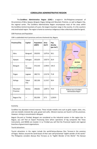
  • 1. CORDILLERA ADMINISTRATIVE REGION The Cordillera Administrative Region (CAR) is a region in the Philippines composed of the provinces of Abra, Apayao, Benguet, Ifugao, Kalinga and Mountain Province, as well as Baguio City, the regional center. The Cordillera Administrative Region encompasses most of the areas within the Cordillera Central mountains of Luzon, the largest mountain range in the country. It is the country's only land-locked region. The region is home to numerous indigenous tribes collectively called the Igorot. CAR Provinces and Population CAR is subdivided into 6 provinces and one chartered city, Baguio. Province/City Capital Population Area Pop. (2007) (km²) density (per km²) Abra Bangued 230,953 3,975.6 58.1 Apayao Kabugao 103,633 3,927.9 26.4 Benguet La 372,533 2,599.4 143.3 Trinidad Ifugao Lagawe 180,711 2,517.8 71.8 Kalinga Tabuk 182,326 3,119.7 58.4 City Mountain Bontoc 148,661 2,097.3 70.9 Political map of Cordillera Province Administrative Region Baguio City — 301,926 57.5 5,250.9 Economy Cordillera has abundant mineral reserves. These include metallic ores such as gold, copper, silver, zinc, and non-metallic minerals like sand, gravel and sulfur. Mineral reserves are found in all the provinces. However, mining is concentrated in Benguet. Baguio City and La Trinidad, Benguet are considered as the industrial centers in the region due. In Baguio, you will find an Export Processing Zone where operations of big companies like Texas Instruments, and MOOG are located. In La Trinidad you will find the Provincial Capitol and regional branches of government organizations. Tourist attractions Tourist attractions in the region include the world-famous Banaue Rice Terraces in the province of Ifugao. Nations around the world boast of their own self-proclaimed "eighth wonder of the world." The Philippines considers Banaue Rice Terraces as its "Eighth Wonder of the World." The Banaue
  • 2. terraces, ancient sprawling man-made structures from 2,000 to 6,000 years old, are a UNESCO World Heritage Site. They are part of the Rice Terraces of the Philippine Cordilleras, widely found in the provinces of Apayao, Benguet, Ifugao, Kalinga, and Mountain Province. Natural attractions of the region include the Sumaguing Cave in Sagada and the mummy caves of Benguet and Mt. Province. There are four National Parks: Cassamata Hill, Mount Pulag, the highest mountain in Luzon, and second highest mountain in the Philippines, following Mount Apo of Davao, with an elevation of 2,922 meters above mean sea level, Mt. Data, and Balbalasang-Balbalan, located in the province of Kalinga. Kalinga also offers world-class white water rafting along the Chico River. The summer capital of the Philippines is Baguio, within the Cordillera Administrative Region. The Banaue Rice Terraces (Tagalog: Hagdan-hagdang Palayan ng Banawe) also called Payew, are 2000- year old terraces that were carved into the mountains of Ifugao in the Philippines by ancestors of the indigenous people. The Rice Terraces are commonly referred to by Filipinos as the "Eighth Wonder of the World". It is commonly thought that the terraces were built with minimal equipment, largely by hand. The terraces are located approximately 1500 meters (5000 ft) above sea level and cover 10,360 square kilometers (about 4000 square miles) of mountainside. They are fed by an ancient irrigation system from the rainforests above the terraces. It is said that if the steps are put end to end it would encircle half the globe. Culture The Cordillera region is known for its unique musical instruments including the gangsa kalinga, nose flute, bamboo flute, buzzer, bangibang, tongatong, diwdiw-as, saggeypo, and bamboo zither. The region also has various festivals. They include: Panagbenga / Baguio Flower Festival which is celebrated in February. The festival focuses on Baguio as the Flower Garden City of the North. Highlights include flower exhibits, lectures, garden tours, floral competition and a parade of floats. Adivay festival in Benguet which means "coming together of people to celebrate" is celebrated every month of November. The month-long activities highlights the Agro-industrial and trade fair which showcase the different products of Benguet. Ullalim Festival/ in Kalinga which is celebrated every February 14. It is in celebration of the founding anniversary of the province and the Peace acts calledBodong. It is the poetic expression of the heroic exploits, romance, joys, successes as well as tribulations, and the way of life of the Kalingas from birth to death. The Festival highlights the weaved clothes (laga) exhibits, world class coffee beans and other products of Kalinga.
  • 3. LANG-AY Festival in Mountain Province celebrated every April 7. This is a week-long agro-industrial trade, tourism and cultural fair with tribal dances and songs. Lang-ay is a native term which describes the tradition of the people of Mountain Province to celebrate festivities, share happiness, foster family solidarity, hospitality and nurture friendship - all with a toast of home-brewed wine. Banaue Imbayah festival which is celebrated every 4 years. It is a three-day festival from December 5 to 8 consisting of a parade portraying the evolution of the Ifugao culture followed by ethnic games. Tabuk Matagoan Festival which features G-String marathon (runners wear G-String only), cultural dances and songs. The festival showcases the different products of tabuk coming from the different parts of Kalinga such as the aromatic Kalinga coffee. Abra (province) Abra is a landlocked province of the Philippines in the Cordillera Administrative Region in Luzon. Its capital is Bangued, and it borders Ilocos Norteand Apayao on the north, Ilocos Sur and Mountain Province on the south, Ilocos Norte and Ilocos Sur on the west, and Kalinga, and Apayao on the east. Demographics Abra's inhabitants are mostly descendants of Ilocano settlers and members of the Tingguian tribe. As of 2007, the population of the province is 230,953. The predominant languages are Ilocano and Itneg. Based on the 2000 census survey, the majority of the province population is Ilocano 71.9%. Other ethnic groups living in the province are the Tinguian 18.7%, Ibanag 4.5%, Isneg 3.2% and Tagalog 0.4%. History The first inhabitants of Abra were the ancestors of the Bontocs and the Ifugaos. These inhabitants eventually left to settle in the old Mountain Province. Other early inhabitants were the Tingguians, or Itnegs, as they are also known. The Ilocos came to trade with the tinguians but eventually they saw the province to be very good so they invaded and the tinguians were forced to go to the mountains. In 1598 a Spanish garrison was established in Bangued to protect the Ilocanos who converted to Christianity from Tingguian raids. During the British Occupation of the Philippines, Gabriela Silang and her army fled to Abra from Ilocos and continued the revolt begun by her slain husband, Diego Silang. She was captured and hung by the Spanish in 1763. In 1818 the Ilocos region, including Abra, was divided into Ilocos Norte and Ilocos Sur. In 1846 Abra was created[4] as a political-military province with Lepanto as a sub-province. It remained so until the arrival of the Americans in 1899. In 1908 the Philippine Commission once again in annexed Abra to Ilocos Sur in an attempt to resolve Abra's financial difficulties. But on March 9, 1917, the Philippine Assembly re-established Abra as a province. In 1942, the Japanese forces occupied the Philippines and entered Abra. In 1945, the liberation in Abra in Northern Luzon by the Philippine Commonwealth forces and the local Cordilleran guerrillas against the Japanese during the Battle of Abra at the end the Second World War. The revolutionary Marxist priest, Conrado Balweg, who fought for the rights of the Cordillera tribes, began his crusade in Abra. After successfully negotiating a peace accord with Balweg's group in 1987, the Philippine government created the Cordillera Administrative Region, which includes Abra. Physical Abra is hemmed in by the towering mountain ranges of the Ilocos in the west and the Cordillera Central in the east. It has an extremely rugged terrain, with mountains and hills rising along its perimeter and interior. The plains are drained by the Abra River, which flows northward from Mt. Data in the Mountain Province.
  • 4. Economy As of 1990, there were 743 cottage industries in Abra, of which 208 are registered with the Department of Trade and Industry. 59% are engaged in bamboo and rattan craft making, both leading industries in the area. In 1992, the natural dye industry, together with loom weaving and embroidery, was revived by former Governor Ma. Zita Claustro-Valera, the first woman governor of Abra. Abra's economy is agriculture-based. Its major crops are rice, corn, and root crops; and commercial produce are coffee, tobacco, and coconut. Extensive grassland and pasture areas are used for livestock production. Apayao Apayao is a landlocked province of the Philippines in the Cordillera Administrative Region in Luzon. Its administrative capital is Luna and founding capital Kabugao. It borders Cagayan to the north and east, Abra and Ilocos Norte to the west, and Kalinga to the south. Prior to 1995, Kalinga and Apayao comprised a single province named Kalinga-Apayao, until they were split into two to better service the needs of individual native tribes in the provinces. Economy Apayao is devoted to agricultural production, particularly food and industrial crops such as palay, corn, coffee, root crops and vegetables. Main fruits produce are lanzones, citrus, bananas and pineapples. Rice production totals 42,602 metric tons annually, as food crops totals 96,542 metric tons. Economic activity is also based on livestock and poultry breeding such as swine, carabao, cattle, goat and sheep. Other additional investment includes manufacturing, food processing, furniture, crafts and house wares making. History Although Apayao was among the earliest areas penetrated by the Spaniards in the Cordilleras, the region, inhabited by the Isneg tribe, remained largely outside Spanish control until late in the 19th century. As early as 1610, the Dominican friars established a mission in what is now the town ofPudtol. In 1684, the friars again made vain attempts to convert the people and established a church in what is now Kabugao. The ruins of the early churches in Pudtol and Kabugao still stand as mute testimony to the failed attempts to occupy Apayao. The Spanish authorities were then able to establish the comandancias of Apayao and Cabugaoan in 1891, which covered the western and eastern portions of what is now Apayao. The comandancias, however, failed to bring total control and the Spanish government only maintained a loose hold over the area. The Americans established the Mountain Province on August 13, 1908, with the enactment of Act No. 1876. Apayao, along with Amburayan,Benguet, Bontoc, Ifugao, Kalinga, and Lepanto, became sub- provinces of this new province. Before this, Apayao had been a part of Cagayanprovince. In 1942, Japanese Imperial forces entered Apayao, starting a three-year occupation of the province during the Second World War. Local Filipino troops of the 1st, 2nd, 12th, 15th and 16th Infantry Division of the Philippine Commonwealth Army and the military forces of the USAFIP-NL 11th and 66th Infantry Regiment, supported by the Cordilleran guerrillas, drove out the Japanese in 1945. After almost 60 years, on June 18, 1966, the huge Mountain Province was split into four provinces with the enactment of Republic Act No. 4695. The four provinces were Benguet, Bontoc (renamed Mountain Province), Kalinga-Apayao and Ifugao. Kalinga-Apayao, along with Ifugao, became one of the provinces of the Cagayan Valley region in 1972.
  • 5. On July 15, 1987, the Cordillera Administrative Region was established and Kalinga-Apayao was made one of its provinces. Finally, on February 14, 1995, Kalinga-Apayao was split into two distinct provinces with the passage of Republic Act No. 7878. The merged outlines of Apayao and Kalinga resemble a bust of a man akin to former President Ferdinand Marcos (looking toward his home province,Ilocos Norte) whom the media called as the "Great Profile" during the Marcos Era. Demographics Based on the 2000 census survey, half of the population is Ilocano 50.82% and almost 1/3 of the population is Isnag 29.95%. Other ethnic groups living in the province are the Malaueg 3.69%, Isneg3.48%, Kalinga 3.08%, Ibaloi 1.01%, Kankana-ey 1.24% and Bontok 1.04%. Benguet ɡet] Benguet [beŋˈ is a landlocked province of the Philippines in the Cordillera Administrative Region in Luzon. Its capital is La Trinidad and borders, clockwise from the south, Pangasinan, La Union, Ilocos Sur, Mountain Province, Ifugao, and Nueva Vizcaya. Baguio, a popular tourist destination in the country, is located in the interior of the province, however, the city is independent of the province. Demographics Based on the May 2000 census, Benguet has a total population of 330,129, which makes it the most populous province in the region. This figure is up by 16,296 from 313,833 persons recorded in the 1995 census, giving an annual growth rate of 1.09% during the 5-year period—much, much lower than the national average of 2.43%. If this growth rate were maintained, Benguet would double its population in approximately 64 years. The province registered at 63,123 households, an increase of 4,588 households over the 1990 figure. This gave an average household size of 5.2 persons, a little higher than the national average of 4.99. Benguet is the homeland of several tribes, collectively referred to as the Igorot. Two of them, the Ibaloi in the southeast and the Kankana-ey in the northwest, are the dominant tribes of Benguet. In the 2000 census, 43% of the household population were Kankana-ey. About 29.2% were Ibaloi and 13.4% were Ilocano. Other ethnic groups included Ikalahan (3.7%) and Tagalog (2.4%). Languages Most of the tribes in Benguet have their own languages. The Ibaloi tribe speak Ibaloy, which is similar to Pangasinan. The Kankana-ey tribe speak have their own language, which is related to the Bontoc language. Many inhabitants also speak Ilocano, Tagalog, and English for trade and commerce. Economy Agriculture, mining, and tourism are the major industries in Benguet. Because of its temperate climate and high altitude, Benguet is an ideal place for producing vegetables. Benguet is often called the Salad Bowl of the Philippines. During February 2007, Benguet suffered crop damage due to freezing temperatures in the area, reaching as low as 5 Celsius and even lower in some areas, and important crops like cabbages were damaged. Major crops include potatoes, Baguio beans, peas, strawberries, cabbage, lettuce, and carrots. Other agricultural-related activities are monggoprocessing, fruit preservation, peanut brittle manufacturing, broom making, basket weaving, and flower growing. Apisang (scientific name: Pittosporum resiniferum), a plant endemic to the Philippines, is also being grown in Kapangan and Kibungan towns as a potential alternative source of fuel and energy, rivaling the overhyped jatropha biofuel plant. Mining is another major industry of Benguet, which is one of the country's leading gold producers. The Benguet Corporation one of the Philippines largest diversified conglomerates was founded to exploit mines in Benguet Province. Other mineral deposits are silver, copper, pyrite, and limestone. Silversmithing is a large industry in Benguet, and many entrepreneurs sell silver works at lower prices in Baguio City, compared to Manila. In 2006 alone revenues from mining reached a
  • 6. stunning four billion pesos, and yet this figure comes from just two-Lepanto Consolidated Mining Corporation and Philex Mines- of the many mining firms operating in the province. Nevertheless, the province's mining vigor has never translated into better quality of life of the Benguet people, simply because a bulk of the mining firm's taxes are not paid directly to the province. The two mining corporations, like many others around the country, have principal offices in the City of Makati, a set-up that makes Makati the prime mining tax beneficiary. The presence of Baguio City in Benguet draws a large number of tourists from the lowlands. Often, people who go to Baguio also explore the province, especially the strawberry and vegetable plantations in La Trinidad. Ifugao Ifugao is a landlocked province of the Philippines in the Cordillera Administrative Region in Luzon. Covering a total land area of 262,820 hectares, the province of Ifugao is located in a mountainous region characterized by rugged terrain, river valleys, and massive forests. Its capital is Lagaweand borders Benguet to the west, Mountain Province to the north, Isabela to the east, and Nueva Vizcaya to the south. It is named after the term "i-pugo" which means "i" (from/people) and "pugo" (hill), thus people of the hill. The Rice Terraces of the Philippine Cordilleras and Banaue Rice Terraces are the main tourist attractions in the province. These 2000-year-old terraces were carved into the mountains, without the aid of machinery, to provide level steps where the natives can plant rice. In 1995, they were declared a UNESCO World Heritage Site. Mountain tribes in Northern Luzon Traveling to the northern part of the island Luzon will bring you not only to beautiful landscapes with amazing rice terraces. It will bring you also to the regions with remote villages and colorful and traditional living upland tribal communities. Their ancestors constructed the fascinating rice terraces with the perfect working irrigation systems. These mountain tribes still distinguish themselves by their specific cultural expression and their skills. They have skills in making bowls, baskets, weapons and clothing. It was the Ifugao people who built up the rice terraces. They are still living and working as in the past. In the past the Ifugao were feared head-hunters, just as other tribes in the mountainous regions of northern Luzon. The war-dance (the bangibang) is one of the cultural remnants of the time of tribal conflict. This dance is traditionally held on the walls of the rice terraces by the men, equipped with spears, axes and wooden shields and a headdress made of leaves. People and culture The People of Ifugao are not called "IGOROTS" but are called IFUGAOS. Ifugaos are different from any other tribe in the cordilleras ranging from culture, tradition, language, and idealism. There have been no Ifugao beggar recorded in history. Some neighboring tribes of the Ifugaos tries to annex or connects themselves with Ifugao so as to share fame the ifugao people are experiencing. Rice culture Ifugao culture revolves around the rice, which is considered a prestige crop. There is an elaborate and complex array of rice culture feasts inextricably linked with taboos and intricate agricultural rites, from rice cultivation to rice consumption. Harvest season calls for grandiose thanksgiving feasts, while the concluding harvest rites "tungo" or "tungul" (the day of rest) entail a strict taboo of any agricultural work. Partaking of the rice wine (bayah), rice cakes, and moma (mixture of several herbs, powdered snail shell and betel nut/ arecoline: and acts as a chewing gum to the ifugaos) is an indelible practice during the festivities and ritual activities.
  • 7. Kalinga Kalinga (Tagalog pronunciation: [kɐˈ liŋɐ]) is a landlocked province of the Philippines in the Cordillera Administrative Region in Luzon. Its capital isTabuk and borders Mountain Province to the south, Abra to the west, Isabela to the east, Cagayan to the northeast, and Apayao to the north. Prior to 1995, Kalinga and Apayao used to be a single province named Kalinga-Apayao, until they were split into two to better service the needs of individual native tribes in the provinces. Geography Political Kalinga is subdivided into 1 city and 7 municipalities. Tabuk was proclaimed a component city in 2007, but in November 2008 the Supreme Court of the Philippines ruled that its cityhood was unconstitutional. However, Tabuk had its city status reinstated by the Supreme Court on December 22, 2009. City  Tabuk Municipalities  Balbalan  Rizal (Liwan)  Lubuagan  Tanudan  Pasil  Tinglayan  Pinukpuk The topography of Kalinga province is rugged and sloping with mountain peaks ranging from 1,500 to 2,500 meters in height. The province’s geographic feature on the western portion is characterized by sharp crested interlinking peaks of steep slopes, isolated flatlands, plateaus and valleys. The eastern portion is generally rolling and gradually sloping foothills. The province is drained mainly by the Chico River with headwater originating from Mt. Province and empties into the Cagayan River.The Chico River has several tributaries: Bunog River in Tinglayan in the south, the Tanudan and Biga Rivers in the east, Pasil River in the middle, Mabaca and Saltan Rivers in the north. Several small lakes can also be found in Kalinga. These water resources if to be tapped could provide abundant sources for power generation, fishing, irrigation and for domestic use, but would destroy rice terraces, villages, livelihoods, and complete indigenous cultures. The province enjoys an average temperature ranging from 17 to 22 degrees Celsius and Type 3 weather patterns. The dry season extends from November to April. The rest of the year is considered rainy. The heaviest rains usually occur in the months of July to October. Large portion of the lower regions of the province are open grassland suitable for pasture, but the highlands have extensive areas of tropical rainforest and at higher elevation in the west, pine. Rizal and Tabuk with their flatlands are the biggest rice producers. Next in rice production are the mountainous areas – the rice terraces of Balbalan, Lubuagan, Pasil, Pinukpuk, Tinglayan, and Tanudan. Culture There are many sub tribes in the province. The strong sense of tribal membership and filial loyalty results in frequent tribal unrest and occasional outright war. Due to the mountainous terrain and warrior-culture of the people, the Kalingas were able to maintain their culture despite the attempted occupation of the Spaniards, Japanese, and Americans. Unknown to many, the last stand of President Emilio Aguinaldo (First President of the Philippines) was in this province, in Lubuagan, which he proclaimed the national capital, and where the Aguinaldo museum commemorates him and those events. The people of Kalinga are the most extensive rice farmers of the Cordillera peoples, having been blessed with some of the most suitable land for both wet and dry rice farming. Like the Ifugaos, the Kalingas are
  • 8. one of the extensive terrace builders in the country. The Kalingas are also skilled potters with pot making concentrated in the lower Chico River Valley. They are also excellent in basket and loom weaving and metal works. Demographics Based on the 2000 census survey, 64.4% of the population are Kalinga and Ilocanos are 24% of the province population. Other ethnic groups living in the province are the Kankana- ey 2.5%, Ibontoc 1.6%, Tagalog 1.3% and Applai 1%. Mountain Province Mountain Province (Filipino:Lalawigang Bulubundukin) is a landlocked province of the Philippines in the Cordillera Administrative Region in Luzon. Its capital is Bontoc and borders, clockwise from the south, Ifugao, Benguet, Ilocos Sur, Abra, Kalinga, and Isabela. Mountain Province is sometimes incorrectly named Mountain in some foreign references. The name is also incorrectly shortened by locals to Mt. Province, which in turn is read by native Anglophones as "Mount Province". The province was named so for being in the Cordillera Central mountain range found in the upper realms of Luzon island. Mountain Province was also the name of the historical province that included most of the current Cordillera provinces. This old province was established by the Americans in 1908 and was later split in 1966 into Mountain Province, Benguet, Kalinga, Apayao and Ifugao. Mountain province is known for its Mummy caves which contain naturally mummified bodies which probably became so due to the humid atmosphere. The hanging Coffins are also found in the province, these are literally coffins hanging on to the branches of trees, many tourists claim there is no foul odor, the bodies were probably mummified by the atmosphere according to theory. Demographics Based on the 2000 census survey, 52% of the population are Kankana-ey. Other ethnic groups living in the province are the Balangao 13.6%, Ibontoc12%, and other ethnicity compromise about 21.6% of the province's population.[1] Baguio The City of Baguio (Ilokano: Ciudad ti Baguio; Filipino: Lungsod ng Baguio) is a highly urbanized city in northern Luzon in the Philippines. Baguio City was established by Americans in 1900 at the site of an Ibaloi village known as Kafagway. Baguio City was designated by the Philippine Commission as the Summer Capital of the Philippines on June 1, 1903 and incorporated as a city by the Philippine Assembly on September 1, 1909. Baguio is the seat of government of the Cordillera Administrative Region. The name of the city is derived from the word bagiw in Ibaloi, the indigenous language of the Benguet Region, meaning 'moss'. The city is at an altitude of approximately 1500 meters (5100 ft) in the Luzon tropical pine forests ecoregion conducive to the growth of mossy plants and orchids. Baguio City has become the center of business and commerce as well as the center of education in the entire Northern Luzon. History The region around Baguio was first settled primarily by the Ibaloi's and the kankanaey's. In the nearby town of La Trinidad, Benguet, Spaniards established a commandante or military garrison, although Kafagway, as Baguio was once known, was barely touched. In 1901 Japanese and Filipino workers hired by the Americans built Kennon Road, the first road directly connecting Kafagway with the lowlands of Pangasinan. Before this, the only road to Kafagway was Naguilian Road. On September 1, 1909 Baguio was declared a chartered city. The famous American architect Daniel Burnham, one of the earliest successful modern city planners, laid a meticulous plan for the city in 1904. His plan was, nevertheless, realized only to a small extent, primarily due to growth of the city well beyond its initial planned population of 25,000 people. The Americans earlier declared Baguio the Summer Capital of the
  • 9. Philippines on July 1, 1903 and The American Residence as the residence of the American governor- general to escape Manila's summer heat. They further developed Baguio, building parks and public structures such as Wright Park in honor of Governor General Luke E. Wright,Burnham Park in honor of Baguio city planner Daniel Burnham, Governor Pack Road, and Session Road. Burnham Park is an urban park located at the heart of the City of Baguio, in the Philippines. It was named after the American architect and urban planner, Daniel Hudson Burnham who laid the plans for the city. Several stretch of roads around the park lead to Camp John Hay, a former recreational base of the United States Armed Forces in the Philippines. It is a scenic park overlooking Mount Kabuyao, the tallest mountain in the Baguio region. Baguio is the site of the formal surrender of General Tomoyuki Yamashita and Vice Admiral Okochi. It is where they gave up the entire Imperial Japanese Armed Forces to American authorities at the High Commissioner's Residence (now the United States Ambassador's Residence) in Camp John Hay on September 3, 1945, marking the end of World War II. A very strong (Ms = 7.8)[3] earthquake destroyed most of Baguio on July 16, 1990. A significant number of buildings and infrastructure were damaged, major highways were temporarily severed, and a number of houses were leveled or severely shaken with a significant loss of life. Some of the fallen buildings were built on or near fault lines. Baguio City was rebuilt, however, with the aid from the national government and various international donors like Japan, Singapore and other countries. Around May 2003, a petition initiated by Dion Fernandez to declare Baguio a heritage zone was circulated on the Internet and national print media, gaining more than 10,000 signatures. The petition calls upon unspecified officials to create the Zone prior to the Baguio centennial in 2009. In May 2005, the Heritage Conservation Society (HCS) submitted to the Baguio City Council a proposed Special Heritage Bill drafted by HCS Trustee Ivan Henares. It has been approved on second reading but is being opposed by a group of businessmen. Geography and climate Geography Baguio City is located some 1,500 meters above sea level, nestled within the Cordillera Central mountain range in northern Luzon. The city is enclosed by the province of Benguet. It covers a small area of 57.5 square kilometers. Most of the developed part of the city is built on uneven, hilly terrain of the northern section. When Daniel Burnham plotted the plans for the city, he made the City Hall as a reference point where the city limits extend 8.2 kilometers from east to west and 7.2 kilometers from north to south. It is the highest major Philippine city in terms of elevation. Climate Baguio City features a subtropical highland climate under the Koppen climate classification. The city is known for its mild climate. It is because of this that Baguio is nicknamed the "Summer Capital of the Philippines". Owing to its high elevation, the temperature in the city is 8 degrees Celsius lower compared to the average temperature of the rest of the country.[4] Average temperature ranges from 15 to 23 degrees Celsius. It is usually lower during the late and early months of the year. The lowest recorded temperature was 6.3 degrees Celsius on January 18, 1961. This is in contrast to the all-time
  • 10. high of 30.4 degrees Celsius recorded on March 15, 1988 during the 1988 El Niño season.[5] Baguio seldom exceeds 26 degrees Celsius even during the warmest part of the year. Like many other cities with a subtropical highland climate, Baguio sees noticeably less precipitation during its dry season. However, the city has an extraordinary amount of precipitation during the rainy season, with the months of July and August having on average more than 1,000 mm of rain. Baguio averages over 4500 mm of precipitation annually. Government Like most Philippine cities, Baguio is governed by a mayor, vice mayor, and twelve (12) councilors. However, being a highly-urbanized city with its own charter, it is not subject to the jurisdiction of Benguet province, of which it was formerly a part.