
Recomendados
Recomendados
Mais conteúdo relacionado
Semelhante a geoSDI-Overview-092009
Semelhante a geoSDI-Overview-092009 (20)
Último
Último (20)
geoSDI-Overview-092009
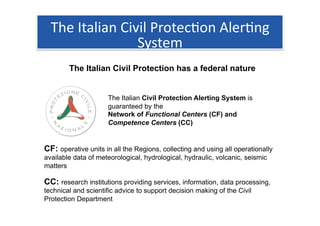
- 1. The Italian Civil Protec1on Aler1ng System The Italian Civil Protection has a federal nature The Italian Civil Protection Alerting System is guaranteed by the Network of Functional Centers (CF) and Competence Centers (CC) CF: operative units in all the Regions, collecting and using all operationally available data of meteorological, hydrological, hydraulic, volcanic, seismic matters CC: research institutions providing services, information, data processing, technical and scientific advice to support decision making of the Civil Protection Department
- 2. Tradi1onal way to manage data Storage / Database You can work with data only by (local/remote) DIRECT ACCESS TO FILE Hundreds of mimetypes (DXF, TIFF, ECW, JPG, PNG, DEM, CSV, SHP, KML …)
- 3. The new Standard The Open Geospatial Consortium, Inc.® (OGC) is a non-profit, international, voluntary consensus standards organization that is leading the development of standards for geospatial and location based services. WMS OGC Open Web Services allow web clients to (Web Map Service) WCS Query and Receive geographic (Web Coverage Service) WFS information (Web Feature Service) … in the form of image, vector, or coverage data.
- 4. Open Web Services With OGC web services you can WMS WCS WFS Query and Receive geographic CSW informa1on VIA INTERNET using standards Desktop Clients / Web Clients
- 5. geoSDI
- 6. The geoSDI Programme geoSDI is a Programme coordinated by the Italian Civil Protection Department • For implemeting the Civil Protection National Spatial Data Infrastructure • According to the provisions of the INSPIRE Directive • Using open source software applications. http://www.geosdi.org It is developed by the Institute for the Methodologies of Environmental Analysis (IMAA) of the Italian National Research Council (CNR) with the collaboration of most of the national civil and military institutions concerned.
- 7. The geoSDI Project geoSDI is also the name of a complete solution for: • Pre-processing data for creating geoSpatial DataStores • Managing and providing OGC Web Services (Server Side Components) • Use OGC Web Services (Client Side Components)
- 8. Data Work Flow • Civil and Military Ins1tu1ons collect data with their own sensors and elaborate them to have geospa1al products • Geospa1al data and products are stored with back‐end geoSDI components for crea1ng OWS services in each node of the federate network • OWS services are based on the stored data and products • The C.P.Dept. and the other involved ins1tu1ons can request and work with the whole pool of OWS available Quantum Gis uDig Google Earth gvSIG
- 9. geoSDI for the C.P.Dept. The Network of CF and CC share geographic information using geoSDI Na1onal, Regional geoSDI ERA and Local authori1es Front‐End OGC (Client Side) Data Production Web Services Providing geoSDI Back‐End (Server Side) Any OGC compliant Client Quantum Gis uDig Google Earth gvSIG Any authority can use geospa1al services from Any authority is a geospa1al data provider the whole federa1on through geoSDI ERA or using the geoSDI back‐end other applica1ons
- 10. Recent geoSDI cases: the Abruzzo Earthquake C.P.Dept Partners produce data rela1ve to the earthquake And share them as OGC Web Services Using the geoSDI Back‐End • Orthophoto • Satellite images • Meteorological products • Interferometry images • Seismic sensors The geoSDI ERA webGIS applicaCon allows to • Damage assessment work with all the geographic infrma1on shared • … between the Federate Organiza1ons
- 11. Recent geoSDI cases: GeoSpa2al Support for the G8 Italian Civil and Military ins1tu1ons used geoSDI components to share geospa1al services concerning the G8 Summit Area
- 12. Some Screenshot Abruzzo Earthquake area of interest and Civil Protec1on structures
- 13. Some Screenshot Orthophoto post‐earthquake (look at the tends!!) and regional technical Map
- 14. Some Screenshot Data from seismic sensors
- 15. Some Screenshot Data from seismic sensors (WFS related info request)
- 16. Some Screenshot Data from seismic sensors (WFS related info request)
- 17. Some Screenshot Landslide phenomena
- 18. Some Screenshot Damaged Buildings
- 19. Some Screenshot Seismic sensor and terrain deforma1on from satellite image processing
- 20. Some Screenshot Map of the Hydrogeological risk in the G8 Area