SlideShare a Scribd company logo
1 of 9
Download to read offline
Convert AutoCAD .dwg files to .shp files:
Making a CAD .dwg file readable in GIS, georeferencing it to
the existing .shp files and converting it to a .shp file.
Part 1: Opening and Georeferencing a .dwg file in ArcMap
1. Start with ArcMap and a shapefile of the area you are trying to match to
your .dwg drawing.
You will need to know the exact coordinates of two points on this existing
.shp file so you can “stretch” or adjust the CAD drawing to match these two
points.
2. You will likely need the full version of ArcGIS (ArcMap) and not the
educational trial version as you will need to utilize the Georeferencing tool.
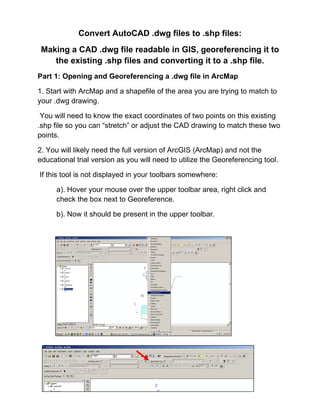
If this tool is not displayed in your toolbars somewhere:
a). Hover your mouse over the upper toolbar area, right click and
check the box next to Georeference.
b). Now it should be present in the upper toolbar.
3. Add the .dwg file just as you would add any other .shp file.
You will get a message box that tells you that you can add the drawing, but
it is not projected. Click OK.
4. Go to the Layer tool (of the Georeferencing toolbar) and select the
polyline, point or polygon option in the drop down menu. (This selection
depends on what you are georeferencing. In this tutorial we are working
with polygons.)
5. In the ArcMap Layers display, select your .dwg file. Make sure your map
is zoomed to about the area where you want to fit your .dwg file.
In the Georeferencing toolbar, select Fit to Display.
This will bring the .dwg immediately over the existing .shp file, though they
will not match up yet…but at least you can see it's in the neighborhood.
Now you are ready to georeference the .dwg file.
6. Click on the icon in the Georeferencing toolbar that has two little x’s, one
green and one red…connected by a small line.
You will use this tool to match two points on the .dwg with two points on the
.shp file.
7. In this tutorial there is a shapefile with two points that correspond with
two corner points of polygons on the .dwg file.
Once you select the tool, your mouse will be a crosshair:
a).Click on the first point to line up on the .dwg layer.
b).Click on the point that matches on the shapefile.
(Zoom in and pan as needed to get more accurate with selecting
these points.)
c). Repeat this with the other points. Ideally, you would do this for two
or more points at opposite corners of the drawing. Less than two can
warp or distort the CAD drawing and reduce the accuracy.
8. Once you have all your points selected with the crosshair tool, select
“Update Display” from the Georeferencing dropdown list.
9. You may want to zoom in on the points you used to align the CAD file
and insure they are lined up. Repeat steps 6-8 until you are satisfied with
the alignment of your .dwg with the rest of your .shp files.
Note: You will notice on the example that
ArcMap imported all the layer types that existed
on the .dwg file. If there are layers you do not
want, click on the box with a plus sign next to the
.dwg listing in the ArcMap Layer display.
Uncheck the CAD layers you do not want. In this
case, the Annotation layer includes the text from
CAD. Uncheck to turn off the text.
Part 2: Convert a .dwg file to a .shp file.
1.Right click on the layer within the .dwg file you want to convert.
Select “Data”. Select “Export Data”.
2. In the “Export Data” window, the default to Export is “All Features”. You
should not have to change any of the other settings except for a place to
save the new file.
Select the folder icon.
Browse to where you want to save the new shapefile.
Name the shapefile. Select Save.
Select OK in the “Export Data” window.
3. A window will open to ask if you would like to add the exported data to
the map as a layer. Select Yes.
Your new shapefile will open onto the map. Now you may remove the .dwg
file from the Layer display.

More Related Content

What's hot

Proctor compaction test
Proctor compaction testProctor compaction test
Proctor compaction testKHK karimi
 
Classification of Pavement Markings (PART -2).pptx
Classification of Pavement Markings (PART -2).pptxClassification of Pavement Markings (PART -2).pptx
Classification of Pavement Markings (PART -2).pptxSHUBHAM SHARMA
 
IRJET- Potential of Natural Bio-Polymers In Stabilization of Soil
IRJET- Potential of Natural Bio-Polymers In Stabilization of SoilIRJET- Potential of Natural Bio-Polymers In Stabilization of Soil
IRJET- Potential of Natural Bio-Polymers In Stabilization of SoilIRJET Journal
 
Negotiated contracts
Negotiated contractsNegotiated contracts
Negotiated contractsSHUBHAM SINGH
 
Subgrade soil test, by Micotol
Subgrade soil test, by MicotolSubgrade soil test, by Micotol
Subgrade soil test, by MicotolMicotol
 
Rotary intersection by ravindra c
 Rotary intersection by ravindra c Rotary intersection by ravindra c
Rotary intersection by ravindra cŔąvî Bøňđ
 
Types of failure in rigid pavements
Types of failure in rigid pavementsTypes of failure in rigid pavements
Types of failure in rigid pavementsAglaia Connect
 
Block 11 blending gradations 13
Block 11 blending gradations 13Block 11 blending gradations 13
Block 11 blending gradations 13Chris Yarnell
 
PENETRATION TEST ON BITUMINOUS MATERIALS.
PENETRATION TEST ON BITUMINOUS MATERIALS.PENETRATION TEST ON BITUMINOUS MATERIALS.
PENETRATION TEST ON BITUMINOUS MATERIALS.Sayed Sajid H.Zidani
 
Vacuum consolidation method worldwide practice and the lastest improvement ...
Vacuum consolidation method   worldwide practice and the lastest improvement ...Vacuum consolidation method   worldwide practice and the lastest improvement ...
Vacuum consolidation method worldwide practice and the lastest improvement ...John Tran
 
Site Surveying Report 2 (Traversing)
Site Surveying Report 2 (Traversing)Site Surveying Report 2 (Traversing)
Site Surveying Report 2 (Traversing)Haziq1511
 
Theodolite angle measurement
Theodolite angle measurementTheodolite angle measurement
Theodolite angle measurementMujeeb Muji
 
L2 Highway planning and development Unit 1.1
L2 Highway planning and development Unit 1.1  L2 Highway planning and development Unit 1.1
L2 Highway planning and development Unit 1.1 Sachin PatiL
 
Chapter 4 earth work and quantities new
Chapter 4 earth work and quantities newChapter 4 earth work and quantities new
Chapter 4 earth work and quantities newBashaFayissa1
 
BITUMINOUS PAVING MIXES PPT
BITUMINOUS PAVING MIXES PPTBITUMINOUS PAVING MIXES PPT
BITUMINOUS PAVING MIXES PPTNischay N Gowda
 
Viscosity test of bitumen
Viscosity test of bitumenViscosity test of bitumen
Viscosity test of bitumenAmrit pandit
 

What's hot (20)

Presentation 1
Presentation 1Presentation 1
Presentation 1
 
Proctor compaction test
Proctor compaction testProctor compaction test
Proctor compaction test
 
Classification of Pavement Markings (PART -2).pptx
Classification of Pavement Markings (PART -2).pptxClassification of Pavement Markings (PART -2).pptx
Classification of Pavement Markings (PART -2).pptx
 
IRJET- Potential of Natural Bio-Polymers In Stabilization of Soil
IRJET- Potential of Natural Bio-Polymers In Stabilization of SoilIRJET- Potential of Natural Bio-Polymers In Stabilization of Soil
IRJET- Potential of Natural Bio-Polymers In Stabilization of Soil
 
Negotiated contracts
Negotiated contractsNegotiated contracts
Negotiated contracts
 
Superpavemixdesign
Superpavemixdesign Superpavemixdesign
Superpavemixdesign
 
Subgrade soil test, by Micotol
Subgrade soil test, by MicotolSubgrade soil test, by Micotol
Subgrade soil test, by Micotol
 
Rotary intersection by ravindra c
 Rotary intersection by ravindra c Rotary intersection by ravindra c
Rotary intersection by ravindra c
 
Types of failure in rigid pavements
Types of failure in rigid pavementsTypes of failure in rigid pavements
Types of failure in rigid pavements
 
Block 11 blending gradations 13
Block 11 blending gradations 13Block 11 blending gradations 13
Block 11 blending gradations 13
 
PENETRATION TEST ON BITUMINOUS MATERIALS.
PENETRATION TEST ON BITUMINOUS MATERIALS.PENETRATION TEST ON BITUMINOUS MATERIALS.
PENETRATION TEST ON BITUMINOUS MATERIALS.
 
Vacuum consolidation method worldwide practice and the lastest improvement ...
Vacuum consolidation method   worldwide practice and the lastest improvement ...Vacuum consolidation method   worldwide practice and the lastest improvement ...
Vacuum consolidation method worldwide practice and the lastest improvement ...
 
Site Surveying Report 2 (Traversing)
Site Surveying Report 2 (Traversing)Site Surveying Report 2 (Traversing)
Site Surveying Report 2 (Traversing)
 
SLUMP TEST AND VEE-BEE TEST
SLUMP TEST AND VEE-BEE TEST SLUMP TEST AND VEE-BEE TEST
SLUMP TEST AND VEE-BEE TEST
 
Theodolite angle measurement
Theodolite angle measurementTheodolite angle measurement
Theodolite angle measurement
 
L2 Highway planning and development Unit 1.1
L2 Highway planning and development Unit 1.1  L2 Highway planning and development Unit 1.1
L2 Highway planning and development Unit 1.1
 
Chapter 4 earth work and quantities new
Chapter 4 earth work and quantities newChapter 4 earth work and quantities new
Chapter 4 earth work and quantities new
 
BITUMINOUS PAVING MIXES PPT
BITUMINOUS PAVING MIXES PPTBITUMINOUS PAVING MIXES PPT
BITUMINOUS PAVING MIXES PPT
 
Road
RoadRoad
Road
 
Viscosity test of bitumen
Viscosity test of bitumenViscosity test of bitumen
Viscosity test of bitumen
 

Viewers also liked

Koreksi geometrik peta (arc gis) registrasi
Koreksi geometrik peta (arc gis) registrasiKoreksi geometrik peta (arc gis) registrasi
Koreksi geometrik peta (arc gis) registrasifikrul islamy
 
Prospectus FPIK Brawijaya university (concept 2012)
Prospectus FPIK Brawijaya university  (concept 2012)Prospectus FPIK Brawijaya university  (concept 2012)
Prospectus FPIK Brawijaya university (concept 2012)fikrul islamy
 
Secrets of supercomputing
Secrets of supercomputingSecrets of supercomputing
Secrets of supercomputingfikrul islamy
 
Akar persamaan2 metnum
Akar persamaan2 metnumAkar persamaan2 metnum
Akar persamaan2 metnumfikrul islamy
 
Bab 3 bangun_datar_dan_bangun_ruang
Bab 3 bangun_datar_dan_bangun_ruangBab 3 bangun_datar_dan_bangun_ruang
Bab 3 bangun_datar_dan_bangun_ruangEka Nuryani
 
KELILING DAN LUAS LINGKARAN (Neni Susanti)
KELILING DAN LUAS LINGKARAN (Neni Susanti)KELILING DAN LUAS LINGKARAN (Neni Susanti)
KELILING DAN LUAS LINGKARAN (Neni Susanti)Neni Susanti
 

Viewers also liked (9)

Koreksi geometrik peta (arc gis) registrasi
Koreksi geometrik peta (arc gis) registrasiKoreksi geometrik peta (arc gis) registrasi
Koreksi geometrik peta (arc gis) registrasi
 
Module net cdf4
Module net cdf4 Module net cdf4
Module net cdf4
 
SIM
SIMSIM
SIM
 
Prospectus FPIK Brawijaya university (concept 2012)
Prospectus FPIK Brawijaya university  (concept 2012)Prospectus FPIK Brawijaya university  (concept 2012)
Prospectus FPIK Brawijaya university (concept 2012)
 
Secrets of supercomputing
Secrets of supercomputingSecrets of supercomputing
Secrets of supercomputing
 
Akar persamaan2 metnum
Akar persamaan2 metnumAkar persamaan2 metnum
Akar persamaan2 metnum
 
Python arch wiki
Python   arch wikiPython   arch wiki
Python arch wiki
 
Bab 3 bangun_datar_dan_bangun_ruang
Bab 3 bangun_datar_dan_bangun_ruangBab 3 bangun_datar_dan_bangun_ruang
Bab 3 bangun_datar_dan_bangun_ruang
 
KELILING DAN LUAS LINGKARAN (Neni Susanti)
KELILING DAN LUAS LINGKARAN (Neni Susanti)KELILING DAN LUAS LINGKARAN (Neni Susanti)
KELILING DAN LUAS LINGKARAN (Neni Susanti)
 

Similar to Convert an auto cad file to a shapefile and georeferencing

Introduction to ArcGIS 10.1
Introduction to ArcGIS 10.1Introduction to ArcGIS 10.1
Introduction to ArcGIS 10.1Claudio Montoni
 
Publishing geoprocessing-services-tutorial
Publishing geoprocessing-services-tutorialPublishing geoprocessing-services-tutorial
Publishing geoprocessing-services-tutorialSebastian Correa Gimenez
 
Soil and Water Assessment Tool Procedure
Soil and Water Assessment Tool ProcedureSoil and Water Assessment Tool Procedure
Soil and Water Assessment Tool ProcedureKEFA FEYE
 
Arc Gis Traininng.pptx
Arc Gis Traininng.pptxArc Gis Traininng.pptx
Arc Gis Traininng.pptxImran khan
 
Cgc Make Your Own Gis
Cgc Make Your Own GisCgc Make Your Own Gis
Cgc Make Your Own GistprattHWDSB
 
RS and GIS TW- 1&2.pdf
RS and GIS TW- 1&2.pdfRS and GIS TW- 1&2.pdf
RS and GIS TW- 1&2.pdfSatishKhadse3
 
Global mapper
Global mapperGlobal mapper
Global mapperupn
 
map design by ArcGIS program
map design by ArcGIS programmap design by ArcGIS program
map design by ArcGIS programAlmoutaz Alsaeed
 
Basic commands of ArcGIS
Basic commands of ArcGISBasic commands of ArcGIS
Basic commands of ArcGISKU Leuven
 
Setting up your DUSP ArcGIS Environment
Setting up your DUSP ArcGIS EnvironmentSetting up your DUSP ArcGIS Environment
Setting up your DUSP ArcGIS EnvironmentDUSPviz
 
Intro to ArcGIS ModelBuilder
Intro to ArcGIS ModelBuilderIntro to ArcGIS ModelBuilder
Intro to ArcGIS ModelBuilderDUSPviz
 
Gis arc map& georeferencing-arcgis
Gis arc map& georeferencing-arcgisGis arc map& georeferencing-arcgis
Gis arc map& georeferencing-arcgisAshok Peddi
 
Cgc Introduction Gis
Cgc Introduction GisCgc Introduction Gis
Cgc Introduction GistprattHWDSB
 
Introduction to-arc map
Introduction to-arc mapIntroduction to-arc map
Introduction to-arc mapAshok Peddi
 
Auto cad 2007-tutorial
Auto cad 2007-tutorialAuto cad 2007-tutorial
Auto cad 2007-tutorialSyed Javeed
 
Nycct GIS_primer tutorial
Nycct  GIS_primer tutorialNycct  GIS_primer tutorial
Nycct GIS_primer tutorialNYCCTfab
 

Similar to Convert an auto cad file to a shapefile and georeferencing (20)

Introduction to ArcGIS 10.1
Introduction to ArcGIS 10.1Introduction to ArcGIS 10.1
Introduction to ArcGIS 10.1
 
Publishing geoprocessing-services-tutorial
Publishing geoprocessing-services-tutorialPublishing geoprocessing-services-tutorial
Publishing geoprocessing-services-tutorial
 
GIS practicals
GIS  practicals GIS  practicals
GIS practicals
 
Soil and Water Assessment Tool Procedure
Soil and Water Assessment Tool ProcedureSoil and Water Assessment Tool Procedure
Soil and Water Assessment Tool Procedure
 
Arc Gis Traininng.pptx
Arc Gis Traininng.pptxArc Gis Traininng.pptx
Arc Gis Traininng.pptx
 
Cgc Make Your Own Gis
Cgc Make Your Own GisCgc Make Your Own Gis
Cgc Make Your Own Gis
 
RS and GIS TW- 1&2.pdf
RS and GIS TW- 1&2.pdfRS and GIS TW- 1&2.pdf
RS and GIS TW- 1&2.pdf
 
Global mapper
Global mapperGlobal mapper
Global mapper
 
map design by ArcGIS program
map design by ArcGIS programmap design by ArcGIS program
map design by ArcGIS program
 
Ex32018.pdf
Ex32018.pdfEx32018.pdf
Ex32018.pdf
 
Get the Sheet out of here! Plan production for jobs due yesterday
Get the Sheet out of here! Plan production for jobs due yesterdayGet the Sheet out of here! Plan production for jobs due yesterday
Get the Sheet out of here! Plan production for jobs due yesterday
 
Basic commands of ArcGIS
Basic commands of ArcGISBasic commands of ArcGIS
Basic commands of ArcGIS
 
Setting up your DUSP ArcGIS Environment
Setting up your DUSP ArcGIS EnvironmentSetting up your DUSP ArcGIS Environment
Setting up your DUSP ArcGIS Environment
 
Intro to ArcGIS ModelBuilder
Intro to ArcGIS ModelBuilderIntro to ArcGIS ModelBuilder
Intro to ArcGIS ModelBuilder
 
Gis arc map& georeferencing-arcgis
Gis arc map& georeferencing-arcgisGis arc map& georeferencing-arcgis
Gis arc map& georeferencing-arcgis
 
Cgc Introduction Gis
Cgc Introduction GisCgc Introduction Gis
Cgc Introduction Gis
 
Introduction to-arc map
Introduction to-arc mapIntroduction to-arc map
Introduction to-arc map
 
High res cartographic modeling lab
High res cartographic modeling labHigh res cartographic modeling lab
High res cartographic modeling lab
 
Auto cad 2007-tutorial
Auto cad 2007-tutorialAuto cad 2007-tutorial
Auto cad 2007-tutorial
 
Nycct GIS_primer tutorial
Nycct  GIS_primer tutorialNycct  GIS_primer tutorial
Nycct GIS_primer tutorial
 

More from fikrul islamy

Kemas & eclogite #GEOLOGI
Kemas & eclogite #GEOLOGI Kemas & eclogite #GEOLOGI
Kemas & eclogite #GEOLOGI fikrul islamy
 
PERMODELAN TSUNAMI UNTUK PENENTUAN ZONA MITIGASI DAN ANALISIS DAMPAK TERHADAP...
PERMODELAN TSUNAMI UNTUK PENENTUAN ZONA MITIGASI DAN ANALISIS DAMPAK TERHADAP...PERMODELAN TSUNAMI UNTUK PENENTUAN ZONA MITIGASI DAN ANALISIS DAMPAK TERHADAP...
PERMODELAN TSUNAMI UNTUK PENENTUAN ZONA MITIGASI DAN ANALISIS DAMPAK TERHADAP...fikrul islamy
 
Lirik & chord lagu mix 1
Lirik & chord lagu mix 1Lirik & chord lagu mix 1
Lirik & chord lagu mix 1fikrul islamy
 
Lirik & chord lagu mix 3
Lirik & chord lagu mix  3Lirik & chord lagu mix  3
Lirik & chord lagu mix 3fikrul islamy
 
Teknologi gis dan analisis spasial di zona pesisir manajemen
Teknologi gis dan analisis spasial di zona pesisir manajemenTeknologi gis dan analisis spasial di zona pesisir manajemen
Teknologi gis dan analisis spasial di zona pesisir manajemenfikrul islamy
 
Pendekatan unt-membangun-sistem
Pendekatan unt-membangun-sistemPendekatan unt-membangun-sistem
Pendekatan unt-membangun-sistemfikrul islamy
 
Koreksi geometrik peta (arc gis) registrasi
Koreksi geometrik peta (arc gis) registrasiKoreksi geometrik peta (arc gis) registrasi
Koreksi geometrik peta (arc gis) registrasifikrul islamy
 
Bangun datar dan bangun datar
Bangun datar dan bangun datarBangun datar dan bangun datar
Bangun datar dan bangun datarfikrul islamy
 
Pengolahan sst satelit modis
Pengolahan sst satelit modisPengolahan sst satelit modis
Pengolahan sst satelit modisfikrul islamy
 
Coastal zone management ruang pesisir
Coastal zone management ruang pesisirCoastal zone management ruang pesisir
Coastal zone management ruang pesisirfikrul islamy
 
Peta dan-penggunaanya
Peta dan-penggunaanyaPeta dan-penggunaanya
Peta dan-penggunaanyafikrul islamy
 
Algoritma dan flowchart
Algoritma dan flowchartAlgoritma dan flowchart
Algoritma dan flowchartfikrul islamy
 
Teknologi gis dan analisis spasial di zona pesisir manajemen
Teknologi gis dan analisis spasial di zona pesisir manajemenTeknologi gis dan analisis spasial di zona pesisir manajemen
Teknologi gis dan analisis spasial di zona pesisir manajemenfikrul islamy
 
Secrets of supercomputing
Secrets of supercomputingSecrets of supercomputing
Secrets of supercomputingfikrul islamy
 

More from fikrul islamy (20)

sedimen transport
sedimen transportsedimen transport
sedimen transport
 
Marine mammals
Marine mammalsMarine mammals
Marine mammals
 
Kemas & eclogite #GEOLOGI
Kemas & eclogite #GEOLOGI Kemas & eclogite #GEOLOGI
Kemas & eclogite #GEOLOGI
 
PERMODELAN TSUNAMI UNTUK PENENTUAN ZONA MITIGASI DAN ANALISIS DAMPAK TERHADAP...
PERMODELAN TSUNAMI UNTUK PENENTUAN ZONA MITIGASI DAN ANALISIS DAMPAK TERHADAP...PERMODELAN TSUNAMI UNTUK PENENTUAN ZONA MITIGASI DAN ANALISIS DAMPAK TERHADAP...
PERMODELAN TSUNAMI UNTUK PENENTUAN ZONA MITIGASI DAN ANALISIS DAMPAK TERHADAP...
 
Lirik & chord lagu mix 1
Lirik & chord lagu mix 1Lirik & chord lagu mix 1
Lirik & chord lagu mix 1
 
Lirik & chord lagu mix 3
Lirik & chord lagu mix  3Lirik & chord lagu mix  3
Lirik & chord lagu mix 3
 
Teknologi gis dan analisis spasial di zona pesisir manajemen
Teknologi gis dan analisis spasial di zona pesisir manajemenTeknologi gis dan analisis spasial di zona pesisir manajemen
Teknologi gis dan analisis spasial di zona pesisir manajemen
 
Quali tas movie
Quali tas movieQuali tas movie
Quali tas movie
 
Pendekatan unt-membangun-sistem
Pendekatan unt-membangun-sistemPendekatan unt-membangun-sistem
Pendekatan unt-membangun-sistem
 
Koreksi geometrik peta (arc gis) registrasi
Koreksi geometrik peta (arc gis) registrasiKoreksi geometrik peta (arc gis) registrasi
Koreksi geometrik peta (arc gis) registrasi
 
Bangun datar dan bangun datar
Bangun datar dan bangun datarBangun datar dan bangun datar
Bangun datar dan bangun datar
 
Pengolahan sst satelit modis
Pengolahan sst satelit modisPengolahan sst satelit modis
Pengolahan sst satelit modis
 
Coastal zone management ruang pesisir
Coastal zone management ruang pesisirCoastal zone management ruang pesisir
Coastal zone management ruang pesisir
 
Peta dan-penggunaanya
Peta dan-penggunaanyaPeta dan-penggunaanya
Peta dan-penggunaanya
 
Peta dan-demografi
Peta dan-demografiPeta dan-demografi
Peta dan-demografi
 
Pergerakan lempeng
Pergerakan lempengPergerakan lempeng
Pergerakan lempeng
 
Algoritma dan flowchart
Algoritma dan flowchartAlgoritma dan flowchart
Algoritma dan flowchart
 
Handout kartografi
Handout kartografiHandout kartografi
Handout kartografi
 
Teknologi gis dan analisis spasial di zona pesisir manajemen
Teknologi gis dan analisis spasial di zona pesisir manajemenTeknologi gis dan analisis spasial di zona pesisir manajemen
Teknologi gis dan analisis spasial di zona pesisir manajemen
 
Secrets of supercomputing
Secrets of supercomputingSecrets of supercomputing
Secrets of supercomputing
 

Recently uploaded

INTRODUCTION TO CATHOLIC CHRISTOLOGY.pptx
INTRODUCTION TO CATHOLIC CHRISTOLOGY.pptxINTRODUCTION TO CATHOLIC CHRISTOLOGY.pptx
INTRODUCTION TO CATHOLIC CHRISTOLOGY.pptxHumphrey A Beña
 
call girls in Kamla Market (DELHI) 🔝 >༒9953330565🔝 genuine Escort Service 🔝✔️✔️
call girls in Kamla Market (DELHI) 🔝 >༒9953330565🔝 genuine Escort Service 🔝✔️✔️call girls in Kamla Market (DELHI) 🔝 >༒9953330565🔝 genuine Escort Service 🔝✔️✔️
call girls in Kamla Market (DELHI) 🔝 >༒9953330565🔝 genuine Escort Service 🔝✔️✔️9953056974 Low Rate Call Girls In Saket, Delhi NCR
 
Transaction Management in Database Management System
Transaction Management in Database Management SystemTransaction Management in Database Management System
Transaction Management in Database Management SystemChristalin Nelson
 
Procuring digital preservation CAN be quick and painless with our new dynamic...
Procuring digital preservation CAN be quick and painless with our new dynamic...Procuring digital preservation CAN be quick and painless with our new dynamic...
Procuring digital preservation CAN be quick and painless with our new dynamic...Jisc
 
USPS® Forced Meter Migration - How to Know if Your Postage Meter Will Soon be...
USPS® Forced Meter Migration - How to Know if Your Postage Meter Will Soon be...USPS® Forced Meter Migration - How to Know if Your Postage Meter Will Soon be...
USPS® Forced Meter Migration - How to Know if Your Postage Meter Will Soon be...Postal Advocate Inc.
 
Grade 9 Quarter 4 Dll Grade 9 Quarter 4 DLL.pdf
Grade 9 Quarter 4 Dll Grade 9 Quarter 4 DLL.pdfGrade 9 Quarter 4 Dll Grade 9 Quarter 4 DLL.pdf
Grade 9 Quarter 4 Dll Grade 9 Quarter 4 DLL.pdfJemuel Francisco
 
Barangay Council for the Protection of Children (BCPC) Orientation.pptx
Barangay Council for the Protection of Children (BCPC) Orientation.pptxBarangay Council for the Protection of Children (BCPC) Orientation.pptx
Barangay Council for the Protection of Children (BCPC) Orientation.pptxCarlos105
 
Keynote by Prof. Wurzer at Nordex about IP-design
Keynote by Prof. Wurzer at Nordex about IP-designKeynote by Prof. Wurzer at Nordex about IP-design
Keynote by Prof. Wurzer at Nordex about IP-designMIPLM
 
Science 7 Quarter 4 Module 2: Natural Resources.pptx
Science 7 Quarter 4 Module 2: Natural Resources.pptxScience 7 Quarter 4 Module 2: Natural Resources.pptx
Science 7 Quarter 4 Module 2: Natural Resources.pptxMaryGraceBautista27
 
Culture Uniformity or Diversity IN SOCIOLOGY.pptx
Culture Uniformity or Diversity IN SOCIOLOGY.pptxCulture Uniformity or Diversity IN SOCIOLOGY.pptx
Culture Uniformity or Diversity IN SOCIOLOGY.pptxPoojaSen20
 
How to Add Barcode on PDF Report in Odoo 17
How to Add Barcode on PDF Report in Odoo 17How to Add Barcode on PDF Report in Odoo 17
How to Add Barcode on PDF Report in Odoo 17Celine George
 
ENGLISH 7_Q4_LESSON 2_ Employing a Variety of Strategies for Effective Interp...
ENGLISH 7_Q4_LESSON 2_ Employing a Variety of Strategies for Effective Interp...ENGLISH 7_Q4_LESSON 2_ Employing a Variety of Strategies for Effective Interp...
ENGLISH 7_Q4_LESSON 2_ Employing a Variety of Strategies for Effective Interp...JhezDiaz1
 
ACC 2024 Chronicles. Cardiology. Exam.pdf
ACC 2024 Chronicles. Cardiology. Exam.pdfACC 2024 Chronicles. Cardiology. Exam.pdf
ACC 2024 Chronicles. Cardiology. Exam.pdfSpandanaRallapalli
 
Like-prefer-love -hate+verb+ing & silent letters & citizenship text.pdf
Like-prefer-love -hate+verb+ing & silent letters & citizenship text.pdfLike-prefer-love -hate+verb+ing & silent letters & citizenship text.pdf
Like-prefer-love -hate+verb+ing & silent letters & citizenship text.pdfMr Bounab Samir
 
Global Lehigh Strategic Initiatives (without descriptions)
Global Lehigh Strategic Initiatives (without descriptions)Global Lehigh Strategic Initiatives (without descriptions)
Global Lehigh Strategic Initiatives (without descriptions)cama23
 
AMERICAN LANGUAGE HUB_Level2_Student'sBook_Answerkey.pdf
AMERICAN LANGUAGE HUB_Level2_Student'sBook_Answerkey.pdfAMERICAN LANGUAGE HUB_Level2_Student'sBook_Answerkey.pdf
AMERICAN LANGUAGE HUB_Level2_Student'sBook_Answerkey.pdfphamnguyenenglishnb
 
MULTIDISCIPLINRY NATURE OF THE ENVIRONMENTAL STUDIES.pptx
MULTIDISCIPLINRY NATURE OF THE ENVIRONMENTAL STUDIES.pptxMULTIDISCIPLINRY NATURE OF THE ENVIRONMENTAL STUDIES.pptx
MULTIDISCIPLINRY NATURE OF THE ENVIRONMENTAL STUDIES.pptxAnupkumar Sharma
 
Choosing the Right CBSE School A Comprehensive Guide for Parents
Choosing the Right CBSE School A Comprehensive Guide for ParentsChoosing the Right CBSE School A Comprehensive Guide for Parents
Choosing the Right CBSE School A Comprehensive Guide for Parentsnavabharathschool99
 

Recently uploaded (20)

INTRODUCTION TO CATHOLIC CHRISTOLOGY.pptx
INTRODUCTION TO CATHOLIC CHRISTOLOGY.pptxINTRODUCTION TO CATHOLIC CHRISTOLOGY.pptx
INTRODUCTION TO CATHOLIC CHRISTOLOGY.pptx
 
call girls in Kamla Market (DELHI) 🔝 >༒9953330565🔝 genuine Escort Service 🔝✔️✔️
call girls in Kamla Market (DELHI) 🔝 >༒9953330565🔝 genuine Escort Service 🔝✔️✔️call girls in Kamla Market (DELHI) 🔝 >༒9953330565🔝 genuine Escort Service 🔝✔️✔️
call girls in Kamla Market (DELHI) 🔝 >༒9953330565🔝 genuine Escort Service 🔝✔️✔️
 
Transaction Management in Database Management System
Transaction Management in Database Management SystemTransaction Management in Database Management System
Transaction Management in Database Management System
 
Procuring digital preservation CAN be quick and painless with our new dynamic...
Procuring digital preservation CAN be quick and painless with our new dynamic...Procuring digital preservation CAN be quick and painless with our new dynamic...
Procuring digital preservation CAN be quick and painless with our new dynamic...
 
USPS® Forced Meter Migration - How to Know if Your Postage Meter Will Soon be...
USPS® Forced Meter Migration - How to Know if Your Postage Meter Will Soon be...USPS® Forced Meter Migration - How to Know if Your Postage Meter Will Soon be...
USPS® Forced Meter Migration - How to Know if Your Postage Meter Will Soon be...
 
Grade 9 Quarter 4 Dll Grade 9 Quarter 4 DLL.pdf
Grade 9 Quarter 4 Dll Grade 9 Quarter 4 DLL.pdfGrade 9 Quarter 4 Dll Grade 9 Quarter 4 DLL.pdf
Grade 9 Quarter 4 Dll Grade 9 Quarter 4 DLL.pdf
 
Barangay Council for the Protection of Children (BCPC) Orientation.pptx
Barangay Council for the Protection of Children (BCPC) Orientation.pptxBarangay Council for the Protection of Children (BCPC) Orientation.pptx
Barangay Council for the Protection of Children (BCPC) Orientation.pptx
 
Keynote by Prof. Wurzer at Nordex about IP-design
Keynote by Prof. Wurzer at Nordex about IP-designKeynote by Prof. Wurzer at Nordex about IP-design
Keynote by Prof. Wurzer at Nordex about IP-design
 
Science 7 Quarter 4 Module 2: Natural Resources.pptx
Science 7 Quarter 4 Module 2: Natural Resources.pptxScience 7 Quarter 4 Module 2: Natural Resources.pptx
Science 7 Quarter 4 Module 2: Natural Resources.pptx
 
Culture Uniformity or Diversity IN SOCIOLOGY.pptx
Culture Uniformity or Diversity IN SOCIOLOGY.pptxCulture Uniformity or Diversity IN SOCIOLOGY.pptx
Culture Uniformity or Diversity IN SOCIOLOGY.pptx
 
Model Call Girl in Tilak Nagar Delhi reach out to us at 🔝9953056974🔝
Model Call Girl in Tilak Nagar Delhi reach out to us at 🔝9953056974🔝Model Call Girl in Tilak Nagar Delhi reach out to us at 🔝9953056974🔝
Model Call Girl in Tilak Nagar Delhi reach out to us at 🔝9953056974🔝
 
How to Add Barcode on PDF Report in Odoo 17
How to Add Barcode on PDF Report in Odoo 17How to Add Barcode on PDF Report in Odoo 17
How to Add Barcode on PDF Report in Odoo 17
 
ENGLISH 7_Q4_LESSON 2_ Employing a Variety of Strategies for Effective Interp...
ENGLISH 7_Q4_LESSON 2_ Employing a Variety of Strategies for Effective Interp...ENGLISH 7_Q4_LESSON 2_ Employing a Variety of Strategies for Effective Interp...
ENGLISH 7_Q4_LESSON 2_ Employing a Variety of Strategies for Effective Interp...
 
YOUVE GOT EMAIL_FINALS_EL_DORADO_2024.pptx
YOUVE GOT EMAIL_FINALS_EL_DORADO_2024.pptxYOUVE GOT EMAIL_FINALS_EL_DORADO_2024.pptx
YOUVE GOT EMAIL_FINALS_EL_DORADO_2024.pptx
 
ACC 2024 Chronicles. Cardiology. Exam.pdf
ACC 2024 Chronicles. Cardiology. Exam.pdfACC 2024 Chronicles. Cardiology. Exam.pdf
ACC 2024 Chronicles. Cardiology. Exam.pdf
 
Like-prefer-love -hate+verb+ing & silent letters & citizenship text.pdf
Like-prefer-love -hate+verb+ing & silent letters & citizenship text.pdfLike-prefer-love -hate+verb+ing & silent letters & citizenship text.pdf
Like-prefer-love -hate+verb+ing & silent letters & citizenship text.pdf
 
Global Lehigh Strategic Initiatives (without descriptions)
Global Lehigh Strategic Initiatives (without descriptions)Global Lehigh Strategic Initiatives (without descriptions)
Global Lehigh Strategic Initiatives (without descriptions)
 
AMERICAN LANGUAGE HUB_Level2_Student'sBook_Answerkey.pdf
AMERICAN LANGUAGE HUB_Level2_Student'sBook_Answerkey.pdfAMERICAN LANGUAGE HUB_Level2_Student'sBook_Answerkey.pdf
AMERICAN LANGUAGE HUB_Level2_Student'sBook_Answerkey.pdf
 
MULTIDISCIPLINRY NATURE OF THE ENVIRONMENTAL STUDIES.pptx
MULTIDISCIPLINRY NATURE OF THE ENVIRONMENTAL STUDIES.pptxMULTIDISCIPLINRY NATURE OF THE ENVIRONMENTAL STUDIES.pptx
MULTIDISCIPLINRY NATURE OF THE ENVIRONMENTAL STUDIES.pptx
 
Choosing the Right CBSE School A Comprehensive Guide for Parents
Choosing the Right CBSE School A Comprehensive Guide for ParentsChoosing the Right CBSE School A Comprehensive Guide for Parents
Choosing the Right CBSE School A Comprehensive Guide for Parents
 

Convert an auto cad file to a shapefile and georeferencing

  • 1. Convert AutoCAD .dwg files to .shp files: Making a CAD .dwg file readable in GIS, georeferencing it to the existing .shp files and converting it to a .shp file. Part 1: Opening and Georeferencing a .dwg file in ArcMap 1. Start with ArcMap and a shapefile of the area you are trying to match to your .dwg drawing. You will need to know the exact coordinates of two points on this existing .shp file so you can “stretch” or adjust the CAD drawing to match these two points. 2. You will likely need the full version of ArcGIS (ArcMap) and not the educational trial version as you will need to utilize the Georeferencing tool. If this tool is not displayed in your toolbars somewhere: a). Hover your mouse over the upper toolbar area, right click and check the box next to Georeference. b). Now it should be present in the upper toolbar.
  • 2. 3. Add the .dwg file just as you would add any other .shp file. You will get a message box that tells you that you can add the drawing, but it is not projected. Click OK. 4. Go to the Layer tool (of the Georeferencing toolbar) and select the polyline, point or polygon option in the drop down menu. (This selection depends on what you are georeferencing. In this tutorial we are working with polygons.)
  • 3. 5. In the ArcMap Layers display, select your .dwg file. Make sure your map is zoomed to about the area where you want to fit your .dwg file. In the Georeferencing toolbar, select Fit to Display. This will bring the .dwg immediately over the existing .shp file, though they will not match up yet…but at least you can see it's in the neighborhood. Now you are ready to georeference the .dwg file.
  • 4. 6. Click on the icon in the Georeferencing toolbar that has two little x’s, one green and one red…connected by a small line. You will use this tool to match two points on the .dwg with two points on the .shp file. 7. In this tutorial there is a shapefile with two points that correspond with two corner points of polygons on the .dwg file. Once you select the tool, your mouse will be a crosshair: a).Click on the first point to line up on the .dwg layer. b).Click on the point that matches on the shapefile. (Zoom in and pan as needed to get more accurate with selecting these points.)
  • 5. c). Repeat this with the other points. Ideally, you would do this for two or more points at opposite corners of the drawing. Less than two can warp or distort the CAD drawing and reduce the accuracy. 8. Once you have all your points selected with the crosshair tool, select “Update Display” from the Georeferencing dropdown list.
  • 6. 9. You may want to zoom in on the points you used to align the CAD file and insure they are lined up. Repeat steps 6-8 until you are satisfied with the alignment of your .dwg with the rest of your .shp files. Note: You will notice on the example that ArcMap imported all the layer types that existed on the .dwg file. If there are layers you do not want, click on the box with a plus sign next to the .dwg listing in the ArcMap Layer display. Uncheck the CAD layers you do not want. In this case, the Annotation layer includes the text from CAD. Uncheck to turn off the text.
  • 7. Part 2: Convert a .dwg file to a .shp file. 1.Right click on the layer within the .dwg file you want to convert. Select “Data”. Select “Export Data”. 2. In the “Export Data” window, the default to Export is “All Features”. You should not have to change any of the other settings except for a place to save the new file. Select the folder icon.
  • 8. Browse to where you want to save the new shapefile. Name the shapefile. Select Save. Select OK in the “Export Data” window. 3. A window will open to ask if you would like to add the exported data to the map as a layer. Select Yes.
  • 9. Your new shapefile will open onto the map. Now you may remove the .dwg file from the Layer display.