SlideShare uma empresa Scribd logo
1 de 13
Baixar para ler offline
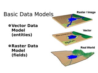
Basic Data Models

  Vector Data
  Model
  (entities)

  Raster Data
  Model
  (fields)
Raster Data Models
  Establishes a pattern of similar grids
  or cells over a geographic area
  The location of each cell is defined by
  its row and column indices
  The value assigned to a cell either
  reflects    the    dominant     feature
  (attribute) at that grid space or
  indicates the presence of a preferred
  feature in case where two or more
  features are present within a single
  grid space
Raster Data Models
  Basic unit in a raster is a cell (or grid
  or pixel)
  Analytically more powerful than the
  vector based GIS
Raster Data Model
3


     5
10
               +               2


                         4
                                                5
                    10             =
                                            9
                                       20
     Direct calculations using raster layers
Comparison between raster and vector
                     Raster    Vector
 Data collection      Rapid     Slow
 Data volume          Large     Small
 Graphic treatment   Average    Good
 Data structure      Simple    Complex
 Geometrical          Low       High
 accuracy
 Analysis in          Poor      Good
 network
 Area analysis        Good     Average
 Generalization      Simple    Complex
Attribute Data
Raster data formats
                             (http://www.gdal.org/formats_list.html)
Arc/Info ASCII Grid , Arc/Info Binary Grid (.adf) , AIRSAR Polarimetric ,
  Microsoft Windows Device Independent Bitmap (.bmp) , BSB Nautical Chart
  Format (.kap) , VTP Binary Terrain Format (.bt) , CEOS (Spot for instance),
  First Generation USGS DOQ (.doq) , DODS / OPeNDAP , New Labelled USGS
  DOQ (.doq) , Military Elevation Data (.dt0, .dt1) , ERMapper Compressed
  Wavelets (.ecw) , ESRI .hdr Labelled , ENVI .hdr Labelled Raster ,
  Envisat Image Product (.n1) , EOSAT FAST Format , FITS (.fits) , Graphics
  Interchange Format (.gif) , Arc/Info Binary Grid (.adf) , GRASS Rasters ,
  TIFF / GeoTIFF (.tif) , Hierarchical Data Format Release 4 (HDF4) ,
  Erdas Imagine (.img) , Atlantis MFF2e , Image Display and Analysis
  (WinDisp) , ILWIS Raster Map (.mpr,.mpl) , Japanese DEM (.mem) , JPEG JFIF
  (.jpg) , JPEG2000 (.jp2, .j2k) , JPEG2000 (.jp2, .j2k) , JPEG2000 (.jp2,
  .j2k) , NOAA Polar Orbiter Level 1b Data Set (AVHRR) , Erdas 7.x .LAN
  and .GIS , In Memory Raster , Atlantis MFF , Multi-resolution Seamless Image
  Database , Meteosat Second Generation , NDF , NITF , NetCDF , OGDI Bridge
  , PCI .aux Labelled , PCI Geomatics Database File , Portable Network
  Graphics (.png) , PCRaster (.map) , Netpbm (.ppm,.pgm) , RadarSat2 XML
  (product.xml) , USGS SDTS DEM (*CATD.DDF) , Raster Matrix Format (*.rsw, .mtw)
  , SAR CEOS , USGS ASCII DEM (.dem) , X11 Pixmap (.xpm)
Creating digital datasets
    by manual input
Georeferencing
●   all spatial data in a common frame of
    reference
●   common coordinate system is plane,
    orthogonal cartesian coordinates
●   referenced with ground and field surveys
    or GPS
●   In GRASS
    –   i.group, i.target, i.points, i.rectify
Northing


           Conformal
           transformation
           X =c 1 ax− by
           Y =c 2 ayby
                            Easting
Raster

Mais conteúdo relacionado

Mais procurados

Arc Geographic Information System (GIS) Digital Elevation Models (DEM).
Arc Geographic Information System (GIS) Digital Elevation Models (DEM).Arc Geographic Information System (GIS) Digital Elevation Models (DEM).
Arc Geographic Information System (GIS) Digital Elevation Models (DEM).Uday Kumar Shil
 
Surface Representations using GIS AND Topographical Mapping
Surface Representations using GIS AND Topographical MappingSurface Representations using GIS AND Topographical Mapping
Surface Representations using GIS AND Topographical MappingNAXA-Developers
 
Getting started with GIS
Getting started with GISGetting started with GIS
Getting started with GISEsri India
 
Introduction to GIS systems
Introduction to GIS systemsIntroduction to GIS systems
Introduction to GIS systemsVivek Srivastava
 
GIS and Mapping Software Introduction
GIS and Mapping Software IntroductionGIS and Mapping Software Introduction
GIS and Mapping Software IntroductionMEASURE Evaluation
 
Geographic Information System for Egyptian Railway System(GIS)
Geographic Information System for Egyptian Railway System(GIS)Geographic Information System for Egyptian Railway System(GIS)
Geographic Information System for Egyptian Railway System(GIS)Ismail El Gayar
 
Data Models - GIS I
Data Models - GIS IData Models - GIS I
Data Models - GIS IJohn Reiser
 
Coordinate systems, datum & map projections
Coordinate systems, datum & map projectionsCoordinate systems, datum & map projections
Coordinate systems, datum & map projectionsKU Leuven
 
An introduction to geographic information systems (gis) m goulbourne 2007
An introduction to geographic information systems (gis)   m goulbourne 2007An introduction to geographic information systems (gis)   m goulbourne 2007
An introduction to geographic information systems (gis) m goulbourne 2007Michelle Goulbourne @ DiaMind Health
 
Basic of gis concept and theories
Basic of gis concept and theoriesBasic of gis concept and theories
Basic of gis concept and theoriesMohsin Siddique
 
Introduction to arc gis
Introduction to arc gisIntroduction to arc gis
Introduction to arc gisMohamed Hamed
 

Mais procurados (20)

Arc Geographic Information System (GIS) Digital Elevation Models (DEM).
Arc Geographic Information System (GIS) Digital Elevation Models (DEM).Arc Geographic Information System (GIS) Digital Elevation Models (DEM).
Arc Geographic Information System (GIS) Digital Elevation Models (DEM).
 
Arcgis training day_1
Arcgis training day_1Arcgis training day_1
Arcgis training day_1
 
Surface Representations using GIS AND Topographical Mapping
Surface Representations using GIS AND Topographical MappingSurface Representations using GIS AND Topographical Mapping
Surface Representations using GIS AND Topographical Mapping
 
Getting started with GIS
Getting started with GISGetting started with GIS
Getting started with GIS
 
Introduction to GIS systems
Introduction to GIS systemsIntroduction to GIS systems
Introduction to GIS systems
 
GIS and Mapping Software Introduction
GIS and Mapping Software IntroductionGIS and Mapping Software Introduction
GIS and Mapping Software Introduction
 
GIS Data Quality
GIS Data QualityGIS Data Quality
GIS Data Quality
 
A short introduction to GIS
A short introduction to GISA short introduction to GIS
A short introduction to GIS
 
History of GIS.pptx
History of GIS.pptxHistory of GIS.pptx
History of GIS.pptx
 
Introduction to GIS
Introduction to GISIntroduction to GIS
Introduction to GIS
 
Types of GIS Data
Types of GIS DataTypes of GIS Data
Types of GIS Data
 
Geographic Information System for Egyptian Railway System(GIS)
Geographic Information System for Egyptian Railway System(GIS)Geographic Information System for Egyptian Railway System(GIS)
Geographic Information System for Egyptian Railway System(GIS)
 
Introduction to GIS
Introduction to GISIntroduction to GIS
Introduction to GIS
 
Data Models - GIS I
Data Models - GIS IData Models - GIS I
Data Models - GIS I
 
Coordinate systems, datum & map projections
Coordinate systems, datum & map projectionsCoordinate systems, datum & map projections
Coordinate systems, datum & map projections
 
An introduction to geographic information systems (gis) m goulbourne 2007
An introduction to geographic information systems (gis)   m goulbourne 2007An introduction to geographic information systems (gis)   m goulbourne 2007
An introduction to geographic information systems (gis) m goulbourne 2007
 
Basic of gis concept and theories
Basic of gis concept and theoriesBasic of gis concept and theories
Basic of gis concept and theories
 
Introduction to arc gis
Introduction to arc gisIntroduction to arc gis
Introduction to arc gis
 
GIS data structure
GIS data structureGIS data structure
GIS data structure
 
Four data models in GIS
Four data models in GISFour data models in GIS
Four data models in GIS
 

Destaque

Data models in geographical information system(GIS)
Data models in geographical information system(GIS)Data models in geographical information system(GIS)
Data models in geographical information system(GIS)Pramoda Raj
 
Raster and vector
Raster and vectorRaster and vector
Raster and vectorleeanne123
 
Vector graphics and raster graphics
Vector graphics and raster graphicsVector graphics and raster graphics
Vector graphics and raster graphicsstephlizahawkins123
 
Raster Vs. Vector Presentation1
Raster Vs. Vector Presentation1Raster Vs. Vector Presentation1
Raster Vs. Vector Presentation1cdoeberl
 
Vectors
VectorsVectors
Vectorseliseb
 
Vector & raster graphic
Vector & raster graphicVector & raster graphic
Vector & raster graphicKhang-Ling Loh
 
Topology presentation
Topology  presentationTopology  presentation
Topology presentationJobaida Nahar
 
Introduction to Vectors
Introduction to VectorsIntroduction to Vectors
Introduction to VectorsM.T.H Group
 
Spatial vs non spatial
Spatial vs non spatialSpatial vs non spatial
Spatial vs non spatialSumant Diwakar
 
Chemical bonding
Chemical bondingChemical bonding
Chemical bondingPramoda Raj
 
raster data model
raster data modelraster data model
raster data modelRiya Gupta
 
Tours les jours2
Tours les jours2Tours les jours2
Tours les jours2chanpinqi
 
Rastar Capabilities
Rastar CapabilitiesRastar Capabilities
Rastar Capabilitiesbsattree
 

Destaque (20)

Topology in GIS
Topology in GISTopology in GIS
Topology in GIS
 
Vectors and Rasters
Vectors and RastersVectors and Rasters
Vectors and Rasters
 
GIS Data Types
GIS Data TypesGIS Data Types
GIS Data Types
 
Data models in geographical information system(GIS)
Data models in geographical information system(GIS)Data models in geographical information system(GIS)
Data models in geographical information system(GIS)
 
Raster and vector
Raster and vectorRaster and vector
Raster and vector
 
Vector graphics and raster graphics
Vector graphics and raster graphicsVector graphics and raster graphics
Vector graphics and raster graphics
 
Raster Vs. Vector Presentation1
Raster Vs. Vector Presentation1Raster Vs. Vector Presentation1
Raster Vs. Vector Presentation1
 
Vectors
VectorsVectors
Vectors
 
Vector & raster graphic
Vector & raster graphicVector & raster graphic
Vector & raster graphic
 
Topology presentation
Topology  presentationTopology  presentation
Topology presentation
 
Introduction to Vectors
Introduction to VectorsIntroduction to Vectors
Introduction to Vectors
 
Spatial vs non spatial
Spatial vs non spatialSpatial vs non spatial
Spatial vs non spatial
 
Vectors
VectorsVectors
Vectors
 
Vectors
Vectors Vectors
Vectors
 
Chemical bonding
Chemical bondingChemical bonding
Chemical bonding
 
raster data model
raster data modelraster data model
raster data model
 
Bb geodatabase
Bb geodatabaseBb geodatabase
Bb geodatabase
 
Tours les jours2
Tours les jours2Tours les jours2
Tours les jours2
 
Rastar Capabilities
Rastar CapabilitiesRastar Capabilities
Rastar Capabilities
 
Spatial Data Model
Spatial Data ModelSpatial Data Model
Spatial Data Model
 

Semelhante a Raster

Conceptual models of real world geographical phenomena (epm107_2007)
Conceptual models of real world geographical phenomena (epm107_2007)Conceptual models of real world geographical phenomena (epm107_2007)
Conceptual models of real world geographical phenomena (epm107_2007)esambale
 
Raster data model
Raster data modelRaster data model
Raster data modelPramoda Raj
 
Raster data model
Raster data modelRaster data model
Raster data modelPramoda Raj
 
Scattered gis handbook
Scattered gis handbookScattered gis handbook
Scattered gis handbookWaleed Liaqat
 
FME Lightning Talk: Raster
FME Lightning Talk: RasterFME Lightning Talk: Raster
FME Lightning Talk: RasterSafe Software
 
FME 2012 World Tour - Lightning Talk on Rasters
FME 2012 World Tour - Lightning Talk on RastersFME 2012 World Tour - Lightning Talk on Rasters
FME 2012 World Tour - Lightning Talk on RastersIMGS
 
Practical data science_public
Practical data science_publicPractical data science_public
Practical data science_publicLong Nguyen
 
Stockage, manipulation et analyse de données matricielles avec PostGIS Raster
Stockage, manipulation et analyse de données matricielles avec PostGIS RasterStockage, manipulation et analyse de données matricielles avec PostGIS Raster
Stockage, manipulation et analyse de données matricielles avec PostGIS RasterACSG Section Montréal
 
Lect 5 data models-gis
Lect 5 data models-gisLect 5 data models-gis
Lect 5 data models-gisRehana Jamal
 
introduction to geographical information system
introduction to geographical information systemintroduction to geographical information system
introduction to geographical information systemDrVenkateswarluGogan1
 
UG6thSem_major_GIS Data Structures.pptx DR P DAS.1.pptx
UG6thSem_major_GIS Data Structures.pptx DR P DAS.1.pptxUG6thSem_major_GIS Data Structures.pptx DR P DAS.1.pptx
UG6thSem_major_GIS Data Structures.pptx DR P DAS.1.pptxNancyVerma72
 
Modelo de dados vetorial e matricial - slides
Modelo de dados vetorial e matricial - slidesModelo de dados vetorial e matricial - slides
Modelo de dados vetorial e matricial - slidesLuzianeRibeiroIndjai
 
Vector and Raster Data data model
Vector and Raster Data data modelVector and Raster Data data model
Vector and Raster Data data modelCalcutta University
 
33286 gis%20 lecture%20six-1
33286 gis%20 lecture%20six-133286 gis%20 lecture%20six-1
33286 gis%20 lecture%20six-1Hisham Ibnuqaiyim
 
spatial databases ADBMS ppt
spatial databases ADBMS pptspatial databases ADBMS ppt
spatial databases ADBMS pptRitaThakkar1
 
Skills portfolio
Skills portfolioSkills portfolio
Skills portfolioyeboyerp
 

Semelhante a Raster (20)

Conceptual models of real world geographical phenomena (epm107_2007)
Conceptual models of real world geographical phenomena (epm107_2007)Conceptual models of real world geographical phenomena (epm107_2007)
Conceptual models of real world geographical phenomena (epm107_2007)
 
Gis Concepts 2/5
Gis Concepts 2/5Gis Concepts 2/5
Gis Concepts 2/5
 
Raster data model
Raster data modelRaster data model
Raster data model
 
Raster data model
Raster data modelRaster data model
Raster data model
 
GIS & Raster
GIS & RasterGIS & Raster
GIS & Raster
 
Scattered gis handbook
Scattered gis handbookScattered gis handbook
Scattered gis handbook
 
FME Lightning Talk: Raster
FME Lightning Talk: RasterFME Lightning Talk: Raster
FME Lightning Talk: Raster
 
FME 2012 World Tour - Lightning Talk on Rasters
FME 2012 World Tour - Lightning Talk on RastersFME 2012 World Tour - Lightning Talk on Rasters
FME 2012 World Tour - Lightning Talk on Rasters
 
Practical data science_public
Practical data science_publicPractical data science_public
Practical data science_public
 
Understanding raster
Understanding rasterUnderstanding raster
Understanding raster
 
Stockage, manipulation et analyse de données matricielles avec PostGIS Raster
Stockage, manipulation et analyse de données matricielles avec PostGIS RasterStockage, manipulation et analyse de données matricielles avec PostGIS Raster
Stockage, manipulation et analyse de données matricielles avec PostGIS Raster
 
Lect 5 data models-gis
Lect 5 data models-gisLect 5 data models-gis
Lect 5 data models-gis
 
Geographical Information System (GIS)
Geographical Information System (GIS)Geographical Information System (GIS)
Geographical Information System (GIS)
 
introduction to geographical information system
introduction to geographical information systemintroduction to geographical information system
introduction to geographical information system
 
UG6thSem_major_GIS Data Structures.pptx DR P DAS.1.pptx
UG6thSem_major_GIS Data Structures.pptx DR P DAS.1.pptxUG6thSem_major_GIS Data Structures.pptx DR P DAS.1.pptx
UG6thSem_major_GIS Data Structures.pptx DR P DAS.1.pptx
 
Modelo de dados vetorial e matricial - slides
Modelo de dados vetorial e matricial - slidesModelo de dados vetorial e matricial - slides
Modelo de dados vetorial e matricial - slides
 
Vector and Raster Data data model
Vector and Raster Data data modelVector and Raster Data data model
Vector and Raster Data data model
 
33286 gis%20 lecture%20six-1
33286 gis%20 lecture%20six-133286 gis%20 lecture%20six-1
33286 gis%20 lecture%20six-1
 
spatial databases ADBMS ppt
spatial databases ADBMS pptspatial databases ADBMS ppt
spatial databases ADBMS ppt
 
Skills portfolio
Skills portfolioSkills portfolio
Skills portfolio
 

Mais de esambale

Open data initiatives
Open data initiativesOpen data initiatives
Open data initiativesesambale
 
Contributing to OpenStreetMap (OSMPH)
Contributing to OpenStreetMap (OSMPH)Contributing to OpenStreetMap (OSMPH)
Contributing to OpenStreetMap (OSMPH)esambale
 
About osmph
About osmphAbout osmph
About osmphesambale
 
Map design
Map designMap design
Map designesambale
 
Geoladies 20140609
Geoladies 20140609Geoladies 20140609
Geoladies 20140609esambale
 
DepEd's Schools Mapping Initiative
DepEd's Schools Mapping InitiativeDepEd's Schools Mapping Initiative
DepEd's Schools Mapping Initiativeesambale
 
State of OpenStreetMap Indonesia
State of OpenStreetMap IndonesiaState of OpenStreetMap Indonesia
State of OpenStreetMap Indonesiaesambale
 
Using OSM, QGIS, and InaSAFE for Contingency Plan in Indonesia
Using OSM, QGIS, and InaSAFE for Contingency Plan in Indonesia Using OSM, QGIS, and InaSAFE for Contingency Plan in Indonesia
Using OSM, QGIS, and InaSAFE for Contingency Plan in Indonesia esambale
 
Participatory mapping and LGU decision support tools for Disaster Risk Reduct...
Participatory mapping and LGU decision support tools for Disaster Risk Reduct...Participatory mapping and LGU decision support tools for Disaster Risk Reduct...
Participatory mapping and LGU decision support tools for Disaster Risk Reduct...esambale
 
InaSAFE Development in the Philippines
InaSAFE Development in the Philippines InaSAFE Development in the Philippines
InaSAFE Development in the Philippines esambale
 
Maperitive
MaperitiveMaperitive
Maperitiveesambale
 
OpenStreetMap QA tools
OpenStreetMap QA toolsOpenStreetMap QA tools
OpenStreetMap QA toolsesambale
 
My GPS Stories
My GPS StoriesMy GPS Stories
My GPS Storiesesambale
 
OSM-Philippines and the Yolanda Crisis Mapping Response
OSM-Philippines and the Yolanda Crisis Mapping ResponseOSM-Philippines and the Yolanda Crisis Mapping Response
OSM-Philippines and the Yolanda Crisis Mapping Responseesambale
 
Free GEO Culture and OpenStreetMap
Free GEO Culture and OpenStreetMapFree GEO Culture and OpenStreetMap
Free GEO Culture and OpenStreetMapesambale
 
ESSC OSM-PH WB project
ESSC OSM-PH WB projectESSC OSM-PH WB project
ESSC OSM-PH WB projectesambale
 
Philippine Geospatial Forum Presentation 20130311
Philippine Geospatial Forum Presentation 20130311Philippine Geospatial Forum Presentation 20130311
Philippine Geospatial Forum Presentation 20130311esambale
 
OSM SFD2012
OSM SFD2012OSM SFD2012
OSM SFD2012esambale
 
FOSS4G 2011 Osaka
FOSS4G 2011 OsakaFOSS4G 2011 Osaka
FOSS4G 2011 Osakaesambale
 
foss4g 2011 tokyo
foss4g 2011 tokyofoss4g 2011 tokyo
foss4g 2011 tokyoesambale
 

Mais de esambale (20)

Open data initiatives
Open data initiativesOpen data initiatives
Open data initiatives
 
Contributing to OpenStreetMap (OSMPH)
Contributing to OpenStreetMap (OSMPH)Contributing to OpenStreetMap (OSMPH)
Contributing to OpenStreetMap (OSMPH)
 
About osmph
About osmphAbout osmph
About osmph
 
Map design
Map designMap design
Map design
 
Geoladies 20140609
Geoladies 20140609Geoladies 20140609
Geoladies 20140609
 
DepEd's Schools Mapping Initiative
DepEd's Schools Mapping InitiativeDepEd's Schools Mapping Initiative
DepEd's Schools Mapping Initiative
 
State of OpenStreetMap Indonesia
State of OpenStreetMap IndonesiaState of OpenStreetMap Indonesia
State of OpenStreetMap Indonesia
 
Using OSM, QGIS, and InaSAFE for Contingency Plan in Indonesia
Using OSM, QGIS, and InaSAFE for Contingency Plan in Indonesia Using OSM, QGIS, and InaSAFE for Contingency Plan in Indonesia
Using OSM, QGIS, and InaSAFE for Contingency Plan in Indonesia
 
Participatory mapping and LGU decision support tools for Disaster Risk Reduct...
Participatory mapping and LGU decision support tools for Disaster Risk Reduct...Participatory mapping and LGU decision support tools for Disaster Risk Reduct...
Participatory mapping and LGU decision support tools for Disaster Risk Reduct...
 
InaSAFE Development in the Philippines
InaSAFE Development in the Philippines InaSAFE Development in the Philippines
InaSAFE Development in the Philippines
 
Maperitive
MaperitiveMaperitive
Maperitive
 
OpenStreetMap QA tools
OpenStreetMap QA toolsOpenStreetMap QA tools
OpenStreetMap QA tools
 
My GPS Stories
My GPS StoriesMy GPS Stories
My GPS Stories
 
OSM-Philippines and the Yolanda Crisis Mapping Response
OSM-Philippines and the Yolanda Crisis Mapping ResponseOSM-Philippines and the Yolanda Crisis Mapping Response
OSM-Philippines and the Yolanda Crisis Mapping Response
 
Free GEO Culture and OpenStreetMap
Free GEO Culture and OpenStreetMapFree GEO Culture and OpenStreetMap
Free GEO Culture and OpenStreetMap
 
ESSC OSM-PH WB project
ESSC OSM-PH WB projectESSC OSM-PH WB project
ESSC OSM-PH WB project
 
Philippine Geospatial Forum Presentation 20130311
Philippine Geospatial Forum Presentation 20130311Philippine Geospatial Forum Presentation 20130311
Philippine Geospatial Forum Presentation 20130311
 
OSM SFD2012
OSM SFD2012OSM SFD2012
OSM SFD2012
 
FOSS4G 2011 Osaka
FOSS4G 2011 OsakaFOSS4G 2011 Osaka
FOSS4G 2011 Osaka
 
foss4g 2011 tokyo
foss4g 2011 tokyofoss4g 2011 tokyo
foss4g 2011 tokyo
 

Último

Transcript: New from BookNet Canada for 2024: BNC CataList - Tech Forum 2024
Transcript: New from BookNet Canada for 2024: BNC CataList - Tech Forum 2024Transcript: New from BookNet Canada for 2024: BNC CataList - Tech Forum 2024
Transcript: New from BookNet Canada for 2024: BNC CataList - Tech Forum 2024BookNet Canada
 
What is Artificial Intelligence?????????
What is Artificial Intelligence?????????What is Artificial Intelligence?????????
What is Artificial Intelligence?????????blackmambaettijean
 
TeamStation AI System Report LATAM IT Salaries 2024
TeamStation AI System Report LATAM IT Salaries 2024TeamStation AI System Report LATAM IT Salaries 2024
TeamStation AI System Report LATAM IT Salaries 2024Lonnie McRorey
 
Digital Identity is Under Attack: FIDO Paris Seminar.pptx
Digital Identity is Under Attack: FIDO Paris Seminar.pptxDigital Identity is Under Attack: FIDO Paris Seminar.pptx
Digital Identity is Under Attack: FIDO Paris Seminar.pptxLoriGlavin3
 
unit 4 immunoblotting technique complete.pptx
unit 4 immunoblotting technique complete.pptxunit 4 immunoblotting technique complete.pptx
unit 4 immunoblotting technique complete.pptxBkGupta21
 
SIP trunking in Janus @ Kamailio World 2024
SIP trunking in Janus @ Kamailio World 2024SIP trunking in Janus @ Kamailio World 2024
SIP trunking in Janus @ Kamailio World 2024Lorenzo Miniero
 
DevoxxFR 2024 Reproducible Builds with Apache Maven
DevoxxFR 2024 Reproducible Builds with Apache MavenDevoxxFR 2024 Reproducible Builds with Apache Maven
DevoxxFR 2024 Reproducible Builds with Apache MavenHervé Boutemy
 
The Role of FIDO in a Cyber Secure Netherlands: FIDO Paris Seminar.pptx
The Role of FIDO in a Cyber Secure Netherlands: FIDO Paris Seminar.pptxThe Role of FIDO in a Cyber Secure Netherlands: FIDO Paris Seminar.pptx
The Role of FIDO in a Cyber Secure Netherlands: FIDO Paris Seminar.pptxLoriGlavin3
 
Time Series Foundation Models - current state and future directions
Time Series Foundation Models - current state and future directionsTime Series Foundation Models - current state and future directions
Time Series Foundation Models - current state and future directionsNathaniel Shimoni
 
"Debugging python applications inside k8s environment", Andrii Soldatenko
"Debugging python applications inside k8s environment", Andrii Soldatenko"Debugging python applications inside k8s environment", Andrii Soldatenko
"Debugging python applications inside k8s environment", Andrii SoldatenkoFwdays
 
Generative AI for Technical Writer or Information Developers
Generative AI for Technical Writer or Information DevelopersGenerative AI for Technical Writer or Information Developers
Generative AI for Technical Writer or Information DevelopersRaghuram Pandurangan
 
Dev Dives: Streamline document processing with UiPath Studio Web
Dev Dives: Streamline document processing with UiPath Studio WebDev Dives: Streamline document processing with UiPath Studio Web
Dev Dives: Streamline document processing with UiPath Studio WebUiPathCommunity
 
The Ultimate Guide to Choosing WordPress Pros and Cons
The Ultimate Guide to Choosing WordPress Pros and ConsThe Ultimate Guide to Choosing WordPress Pros and Cons
The Ultimate Guide to Choosing WordPress Pros and ConsPixlogix Infotech
 
How AI, OpenAI, and ChatGPT impact business and software.
How AI, OpenAI, and ChatGPT impact business and software.How AI, OpenAI, and ChatGPT impact business and software.
How AI, OpenAI, and ChatGPT impact business and software.Curtis Poe
 
Advanced Computer Architecture – An Introduction
Advanced Computer Architecture – An IntroductionAdvanced Computer Architecture – An Introduction
Advanced Computer Architecture – An IntroductionDilum Bandara
 
The Fit for Passkeys for Employee and Consumer Sign-ins: FIDO Paris Seminar.pptx
The Fit for Passkeys for Employee and Consumer Sign-ins: FIDO Paris Seminar.pptxThe Fit for Passkeys for Employee and Consumer Sign-ins: FIDO Paris Seminar.pptx
The Fit for Passkeys for Employee and Consumer Sign-ins: FIDO Paris Seminar.pptxLoriGlavin3
 
Unraveling Multimodality with Large Language Models.pdf
Unraveling Multimodality with Large Language Models.pdfUnraveling Multimodality with Large Language Models.pdf
Unraveling Multimodality with Large Language Models.pdfAlex Barbosa Coqueiro
 
Nell’iperspazio con Rocket: il Framework Web di Rust!
Nell’iperspazio con Rocket: il Framework Web di Rust!Nell’iperspazio con Rocket: il Framework Web di Rust!
Nell’iperspazio con Rocket: il Framework Web di Rust!Commit University
 
What is DBT - The Ultimate Data Build Tool.pdf
What is DBT - The Ultimate Data Build Tool.pdfWhat is DBT - The Ultimate Data Build Tool.pdf
What is DBT - The Ultimate Data Build Tool.pdfMounikaPolabathina
 
Developer Data Modeling Mistakes: From Postgres to NoSQL
Developer Data Modeling Mistakes: From Postgres to NoSQLDeveloper Data Modeling Mistakes: From Postgres to NoSQL
Developer Data Modeling Mistakes: From Postgres to NoSQLScyllaDB
 

Último (20)

Transcript: New from BookNet Canada for 2024: BNC CataList - Tech Forum 2024
Transcript: New from BookNet Canada for 2024: BNC CataList - Tech Forum 2024Transcript: New from BookNet Canada for 2024: BNC CataList - Tech Forum 2024
Transcript: New from BookNet Canada for 2024: BNC CataList - Tech Forum 2024
 
What is Artificial Intelligence?????????
What is Artificial Intelligence?????????What is Artificial Intelligence?????????
What is Artificial Intelligence?????????
 
TeamStation AI System Report LATAM IT Salaries 2024
TeamStation AI System Report LATAM IT Salaries 2024TeamStation AI System Report LATAM IT Salaries 2024
TeamStation AI System Report LATAM IT Salaries 2024
 
Digital Identity is Under Attack: FIDO Paris Seminar.pptx
Digital Identity is Under Attack: FIDO Paris Seminar.pptxDigital Identity is Under Attack: FIDO Paris Seminar.pptx
Digital Identity is Under Attack: FIDO Paris Seminar.pptx
 
unit 4 immunoblotting technique complete.pptx
unit 4 immunoblotting technique complete.pptxunit 4 immunoblotting technique complete.pptx
unit 4 immunoblotting technique complete.pptx
 
SIP trunking in Janus @ Kamailio World 2024
SIP trunking in Janus @ Kamailio World 2024SIP trunking in Janus @ Kamailio World 2024
SIP trunking in Janus @ Kamailio World 2024
 
DevoxxFR 2024 Reproducible Builds with Apache Maven
DevoxxFR 2024 Reproducible Builds with Apache MavenDevoxxFR 2024 Reproducible Builds with Apache Maven
DevoxxFR 2024 Reproducible Builds with Apache Maven
 
The Role of FIDO in a Cyber Secure Netherlands: FIDO Paris Seminar.pptx
The Role of FIDO in a Cyber Secure Netherlands: FIDO Paris Seminar.pptxThe Role of FIDO in a Cyber Secure Netherlands: FIDO Paris Seminar.pptx
The Role of FIDO in a Cyber Secure Netherlands: FIDO Paris Seminar.pptx
 
Time Series Foundation Models - current state and future directions
Time Series Foundation Models - current state and future directionsTime Series Foundation Models - current state and future directions
Time Series Foundation Models - current state and future directions
 
"Debugging python applications inside k8s environment", Andrii Soldatenko
"Debugging python applications inside k8s environment", Andrii Soldatenko"Debugging python applications inside k8s environment", Andrii Soldatenko
"Debugging python applications inside k8s environment", Andrii Soldatenko
 
Generative AI for Technical Writer or Information Developers
Generative AI for Technical Writer or Information DevelopersGenerative AI for Technical Writer or Information Developers
Generative AI for Technical Writer or Information Developers
 
Dev Dives: Streamline document processing with UiPath Studio Web
Dev Dives: Streamline document processing with UiPath Studio WebDev Dives: Streamline document processing with UiPath Studio Web
Dev Dives: Streamline document processing with UiPath Studio Web
 
The Ultimate Guide to Choosing WordPress Pros and Cons
The Ultimate Guide to Choosing WordPress Pros and ConsThe Ultimate Guide to Choosing WordPress Pros and Cons
The Ultimate Guide to Choosing WordPress Pros and Cons
 
How AI, OpenAI, and ChatGPT impact business and software.
How AI, OpenAI, and ChatGPT impact business and software.How AI, OpenAI, and ChatGPT impact business and software.
How AI, OpenAI, and ChatGPT impact business and software.
 
Advanced Computer Architecture – An Introduction
Advanced Computer Architecture – An IntroductionAdvanced Computer Architecture – An Introduction
Advanced Computer Architecture – An Introduction
 
The Fit for Passkeys for Employee and Consumer Sign-ins: FIDO Paris Seminar.pptx
The Fit for Passkeys for Employee and Consumer Sign-ins: FIDO Paris Seminar.pptxThe Fit for Passkeys for Employee and Consumer Sign-ins: FIDO Paris Seminar.pptx
The Fit for Passkeys for Employee and Consumer Sign-ins: FIDO Paris Seminar.pptx
 
Unraveling Multimodality with Large Language Models.pdf
Unraveling Multimodality with Large Language Models.pdfUnraveling Multimodality with Large Language Models.pdf
Unraveling Multimodality with Large Language Models.pdf
 
Nell’iperspazio con Rocket: il Framework Web di Rust!
Nell’iperspazio con Rocket: il Framework Web di Rust!Nell’iperspazio con Rocket: il Framework Web di Rust!
Nell’iperspazio con Rocket: il Framework Web di Rust!
 
What is DBT - The Ultimate Data Build Tool.pdf
What is DBT - The Ultimate Data Build Tool.pdfWhat is DBT - The Ultimate Data Build Tool.pdf
What is DBT - The Ultimate Data Build Tool.pdf
 
Developer Data Modeling Mistakes: From Postgres to NoSQL
Developer Data Modeling Mistakes: From Postgres to NoSQLDeveloper Data Modeling Mistakes: From Postgres to NoSQL
Developer Data Modeling Mistakes: From Postgres to NoSQL
 

Raster

  • 1. Basic Data Models Vector Data Model (entities) Raster Data Model (fields)
  • 2. Raster Data Models Establishes a pattern of similar grids or cells over a geographic area The location of each cell is defined by its row and column indices The value assigned to a cell either reflects the dominant feature (attribute) at that grid space or indicates the presence of a preferred feature in case where two or more features are present within a single grid space
  • 3. Raster Data Models Basic unit in a raster is a cell (or grid or pixel) Analytically more powerful than the vector based GIS
  • 4.
  • 6. 3 5 10 + 2 4 5 10 = 9 20 Direct calculations using raster layers
  • 7. Comparison between raster and vector Raster Vector Data collection Rapid Slow Data volume Large Small Graphic treatment Average Good Data structure Simple Complex Geometrical Low High accuracy Analysis in Poor Good network Area analysis Good Average Generalization Simple Complex
  • 9. Raster data formats (http://www.gdal.org/formats_list.html) Arc/Info ASCII Grid , Arc/Info Binary Grid (.adf) , AIRSAR Polarimetric , Microsoft Windows Device Independent Bitmap (.bmp) , BSB Nautical Chart Format (.kap) , VTP Binary Terrain Format (.bt) , CEOS (Spot for instance), First Generation USGS DOQ (.doq) , DODS / OPeNDAP , New Labelled USGS DOQ (.doq) , Military Elevation Data (.dt0, .dt1) , ERMapper Compressed Wavelets (.ecw) , ESRI .hdr Labelled , ENVI .hdr Labelled Raster , Envisat Image Product (.n1) , EOSAT FAST Format , FITS (.fits) , Graphics Interchange Format (.gif) , Arc/Info Binary Grid (.adf) , GRASS Rasters , TIFF / GeoTIFF (.tif) , Hierarchical Data Format Release 4 (HDF4) , Erdas Imagine (.img) , Atlantis MFF2e , Image Display and Analysis (WinDisp) , ILWIS Raster Map (.mpr,.mpl) , Japanese DEM (.mem) , JPEG JFIF (.jpg) , JPEG2000 (.jp2, .j2k) , JPEG2000 (.jp2, .j2k) , JPEG2000 (.jp2, .j2k) , NOAA Polar Orbiter Level 1b Data Set (AVHRR) , Erdas 7.x .LAN and .GIS , In Memory Raster , Atlantis MFF , Multi-resolution Seamless Image Database , Meteosat Second Generation , NDF , NITF , NetCDF , OGDI Bridge , PCI .aux Labelled , PCI Geomatics Database File , Portable Network Graphics (.png) , PCRaster (.map) , Netpbm (.ppm,.pgm) , RadarSat2 XML (product.xml) , USGS SDTS DEM (*CATD.DDF) , Raster Matrix Format (*.rsw, .mtw) , SAR CEOS , USGS ASCII DEM (.dem) , X11 Pixmap (.xpm)
  • 10. Creating digital datasets by manual input
  • 11. Georeferencing ● all spatial data in a common frame of reference ● common coordinate system is plane, orthogonal cartesian coordinates ● referenced with ground and field surveys or GPS ● In GRASS – i.group, i.target, i.points, i.rectify
  • 12. Northing Conformal transformation X =c 1 ax− by Y =c 2 ayby Easting