POWERPOINT Summary PART I of the 2012 Atlantic hurricane and tropical storm season
•Download as PPT, PDF•
1 like•520 views

POWERPOINT Summary PART I of the 2012 Atlantic hurricane and tropical storm season * Actual Storms Exceeded The Forecast * Forecast: 15 Named Storms With 4-8 Becoming Hurricanes Powerpoint presentation courtesy of Dr Walter Hays, Global Alliance for Disaster Reduction

Recommended
More Related Content
What's hot
What's hot (20)
Viewers also liked
Viewers also liked (20)
Similar to POWERPOINT Summary PART I of the 2012 Atlantic hurricane and tropical storm season
Similar to POWERPOINT Summary PART I of the 2012 Atlantic hurricane and tropical storm season (20)
More from Professor Eric K. Noji, M.D., MPH, DTMH(Lon), FRCP(UK)hon
More from Professor Eric K. Noji, M.D., MPH, DTMH(Lon), FRCP(UK)hon (20)
POWERPOINT Summary PART I of the 2012 Atlantic hurricane and tropical storm season
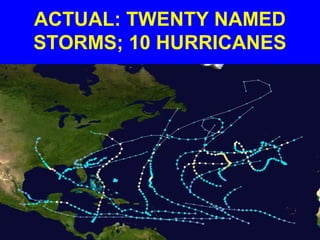
- 1. ACTUAL: TWENTY NAMED STORMS; 10 HURRICANES
- 2. ACTUAL STORMS EXCEEDED THE FORECAST FORECAST: 15 NAMED STORMS WITH 4-8 BECOMING HURRICANES
- 3. NAMED STORMS IN 2012 • ALBERTO - Tropical storm; May 19 • BERYL - Tropical storm; May 27 • CHRIS – Hurricane; June 21 • DEBBY – Tropical storm; June 23 • ERNESTO –Hurricane; Aug 3 • FLORENCE –Tropical storm: Aug 5 • GORDON –Hurricane, August 16
- 4. NAMED STORMS FOR 2012 • HELENE –Tropical Storm, Aug. 19 • ISAAC – Hurricane, August 21 • JOYCE –Tropical Storm, Aug. 25 • KIRK –Tropical Storm. Aug. 27 • LESLIE –Hurricane, Sept. 5 • MICHAEL –Hurricane, Sept. 5 • NADINE – Hurricane, Sept. 12
- 5. NAMED STORMS IN 2012 • OSCAR – Tropical Storm; Oct. 4 • PATTY – Tropical Storm; Oct. 11 • RAFAEL – Hurricane; October 12 • SANDY– Hurricane; October 22 • TONY – Tropical Storm; Oct. 24 • VALERIE– Did not happen • WILLIAM – Did not happen
- 6. TROPICAL STORM ALBERTO --- FIRST STORM OF 2012 SEASON FORMS OFF SOUTH CAROLINA COAST May 19-21, 2012
- 7. ALBERTO ARRIVED 2 WEEKS BEFORE THE 2012 SEASON BEGAN Located about 140 miles east-southeast of Charleston, SC, Alberto had sustained winds of 100 kph (60 mph) As expected, Alberto turned northward and brought rain to the east coast for several days.
- 8. ALBERTO: MAY 19, 2012
- 9. ALBERTO: MAY 20, 2012
- 10. ALBERTO’S POSITION: MAY 20-21 On Sunday, Alberto was 120 miles south of Cape Fear, NC with sustained winds of 83 kph (50 mph) On Monday, Alberto began to turn eastward, indicating that it will likely stay in the Atlantic Ocean and die there.
- 11. SURF BOARDING IN MIAMI THANKS TO ALBERTO: MAY 21, 2012
- 12. TROPICAL STORM BERYL --- SECOND STORM OF 2012 SEASON FORMED OFF NORTH FLORIDA COAST May 27-28, 2012
- 13. BERYL: MAY 28, 2012
- 14. BERYL’S POSITION: MAY 28 Early on Monday morning (12:10 AM), Tropical Storm Beryl made landfall near Jacksonville Beach, FL with near- hurricane winds of 115 kph (70 mph). A rain-maker, Beryl, dumped 10-20 cm (4-8 inches) of rain; a welcome relief for the drought-stricken region. Beryl weakened quickly
- 15. BERYL: A RAINMAKER Beryl became a rainmaker as it weakened and moved northward along the USA’s east coast, complicating the Memorial Day holiday traffic.
- 17. TROPICAL STORM CHRIS --- BECAME FIRST HURRICANE OF 2012 SEASON NO THREAT TO LAND DURING SHORT LIFE June 21, 2012
- 18. HURRICANE CHRIS • Chris had 120 kph (75 mph) winds and was located about 625 miles (1005 km) southeast of Cape Race, Newfound- land, Canada. • It was moving to the northeast at 32 kph (20 mph) with a minimum central pressure of 987 millibars.
- 19. CHRIS: FIRST HURRICANE OF 2012 SEASON
- 20. CHRIS (NO THREAT TO LAND), AND THE PRE-DEBBY DEPRESSION
- 21. TROPICAL STORM DEBBY --- FOURTH STORM OF 2012 SEASON FORMED IN GULF SOUTHWEST OF FLORIDA FIRST TIME IN HISTORY FOR FOUR NAMED STORMS BEFORE JULY 1ST June 23, 2012
- 22. DEBBY: DIRECTION AND INTENSITY UNCERTAIN: JUNE 23
- 23. DEBBY: ANTICIPATORY ACTIONS; JUNE 24 • Debby expected to become a CAT I hurricane • Storm warnings issued from Texas to Florida • Oil rigs in gulf of Mexico begin to shut down production and plan evacuations • Coastal States begin to implement emergency response plans
- 24. DEBBY: DIRECTION AND INTENSITY STILL UNCERTAIN: JUNE 24
- 25. On June 24th, Debby dumped up to 60 cm (24 inches) of rain on parts of Florida and spawned some isolated tornadoes The center of the storm continued to be essentially stationary, increasing the likelihood of being a big rainmaker
- 26. DEBBY CAN’T DECIDE: THE PRE- FERRED MODEL 10 AM JUNE 24
- 27. DEBBY FINALLY DECIDES: IT’S EAST, NOT WEST; JUNE 25
- 28. FLORIDA’S GOVERNOR, RICK SCOTT, DECLARES STATE OF EMERGENCY MONDAY, JUNE 25
- 29. DEBBY: FLOODING IN CEDAR KEY, FLORIDA: JUNE 25
- 30. DEBBY: FLOODING; JUNE 25
- 31. DEBBY: FLOODING; JUNE 25
- 32. DEBBY: FLOODING IN CLEARWATER, FL; JUNE 25
- 33. Tuesday, June 26 Debby, barely a tropical storm, finally made landfall Tuesday afternoon near Steinhatchee in the Big Bend area, with a 60 cm (2 foot) storm surge and sustained winds near 66 kph (40 mph).
- 34. INITIAL IMPACTS IN FLORIDA • Four straight days of rain • The storm left 29,000 people without power across the central and northern parts of the state. • Mandatory evacuation ordered for 14,000 to 20,000 people living between the Anclote and Pithlachascotee Rivers.
- 35. INITIAL IMPACTS IN FLORIDA • The capital, Tallahassee, was cutoff from Jacksonville due to flooding of the Interstate Highway • Debby was expected to bring another 10-20 cm (4 to 8 inches) of rain as it moved across Florida, possibly strengthening again after reaching the Atlantic Ocean
- 36. Wednesday, June 27 Debby is expected to cross the state and head into the Atlantic on Wednesday afternoon.
- 37. JULY 14 NOTE:: Experts are now saying that 2012 is turning out to be an EL NINO YEAR (i.e., a warmer Pacific and a cooler Atlantic than was the case in 2011)
- 38. A QUIET PERIOD JULY 8 – AUGUST 2
- 39. TROPICAL STORM ERNESTO --- FIFTH STORM OF 2012 SEASON SPEEDING TOWARDS THE CARIBBEAN The storm is centered about 90 miles (145 kilometers) west of St. Lucia. And moving west near 21 mph (34 kph). August 3, 2012
- 40. TROPICAL STORM FLORENCE --- SIXTH STORM OF 2012 SEASON FORMED IN EASTERN ATLANTIC The storm, which was moving westward and 515 miles (830 km) west of the southernmost Cape Verde Islands, died quickly August 5, 2012.
- 41. TS ERNESTO’S LOCATION AUGUST 3, 2012
- 42. TS ERNESTO’S PROJECTED PATH: AUGUST 4, 2012
- 43. TS ERNESTO BECAME HURRICANE NEAR HONDURAS: AUG 6
- 44. Ernesto was a weak hurricane when it made its first landfall late Tuesday (Aug. 7) near the cruise ship port of Mahahual in Yucatan,
- 45. Ernesto’s second landfall on Thursday (Aug 9) was as a “Rainmaker” near the Mexican oil port city of Coatzacoalcos Three people killed
- 46. WHAT HAPPENED AFTER LANDFALL? • Heavy rains continued into Friday night as Ernesto’s winds declined quickly to 40 mph (65 kph). .
- 47. VERA CRUZ: FLOODING FROM ERNESTO AUG 10
- 48. TROPICAL STORM GORDON --- SEVENTH STORM OF 2012 SEASON FORMED IN EASTERN ATLANTIC The storm is moving westward at present. August 16, 2012.
- 49. TS GORDON: AUG 16
- 50. TROPICAL STORM GORDON --- EIGHTH STORM OF 2012 SEASON FORMED IN EASTERN ATLANTIC The storm is moving westward at present. August 16, 2012.
- 51. TROPICAL STORM--HURRICANE ISAAC --- NINETH STORM OF 2012 SEASON HEADING FOR CARIBBEAN AND POSSIBLY FLORIDA The storm could affect the Republican National Convention August 21, 2012.
- 52. ISAAC: FROM TS ON AUG, 21 TO HURRICANE ON AUG. 26
- 53. CAT I HURRICANE ISAAC, A HUGE RAINMAKER, WAS DEVASTATING ALONG THE GULF COAST, AND ESPECIALLY IN LOUISIANA SEE SEPARATE FILE
- 54. TS JOYCE: AUG 25
- 55. TS KIRK: SEPT. 1
- 56. LESLIE: FROM A TS ON SEPT 3 TO HURRICANE ON SEPT 5
- 57. ISAAC COULD HAVE RETURNED AS TS NADINE, BUT DIDN’T
- 58. The 2012 season is lagging behind past seasons: By Sept. 5, 2005, we had three major hurricanes (Dennis, Emily, and Katrina),and by Sept. 5, 2011, we had one major hurricane (Katia). This year, we have had none.
- 59. 2012’S CUMMULATIVE IMPACTS 320 DEATHS ECONOMIC LOSSES: ESTIMATED AT $68 BILLION +