SlideShare uma empresa Scribd logo
1 de 17
Baixar para ler offline
International collaboration on open source
scientific software: latest developments in
goGPS positioning engine
Eugenio Realini
Daisuke Yoshida
Hirofumi Hayashi
Venkatesh Raghavan

RISH, Kyoto University
GSCC, Osaka City University
Applied Technology Co.,Ltd
GSCC, Osaka City University

FOSS4G 2013 Osaka
7 November 2013
GPS “raw data”(observations, orbits, …)
If we have:
- satellite positions
- satellite-receiver distances
- precise time

1
11
10

H e ig h t [ k m ]

32

24

28

8

we can estimate:
- receiver position/velocity
- atmospheric parameters
-…

19

20

8

6
7
4
2
0
12

and we can do research:
- positioning accuracy improvement
- deformation monitoring
- atmospheric water vapor retrieval
-…

10
10

8

6
N o rth [k m ]

5
4

2

0

0
E a s t [k m ]
From GPS to GNSS
GPS is not the only positioning system available
Other countries apart from US are building global (or regional)
satellite systems

GNSS Global Navigation Satellite System
GLONASS

BeiDou

Russia

China

Global

Galileo
Europe

QZSS
Japan

IRNSS
India

Regional
GNSS “raw data”(observations, orbits, …)
Standard consumer grade (low-cost) receiver:
- GNSS observations are processed within the receiver
- User can access only the processing result (e.g. coordinates)

GNSS observations

Coordinates
and ancillary data

Only visualization!
GNSS “raw data”(observations, orbits, …)
By accessing raw data, we can perform advanced analyses, e.g.
- improving the positioning accuracy by relative positioning
- study and monitor the atmosphere
- …

Raw
data
Receivers providing “raw data”
GNSS receivers generally provide raw data formatted according to
proprietary binary protocols.
Often these protocols are available to customers (or even public).

Almost all geodetic
(survey grade) receivers
(dual-frequency or
single-frequency)

~ $3,000 – $30,000

A few low-cost
(consumer grade) receivers
(single-frequency)

~ $100 – $500
Low-cost raw data logger prototype
ENVLoggerRPi

-

developed at Osaka City University
u-blox LEA-6T module (GPS raw data)
environmental sensors (T, P, RH, CO2)
logging data on microSD card
Raspberry Pi (credit card-sized Linux computer)
Power-over-Ethernet
Configurable (text file on SD card)
open source firmware
GNSS processing software
Commercial

Academic
GAMIT/GLOBK

TGO/TTC (Trimble)
LGO (Leica)

Bernese

RTNet
Topcon Tools (Topcon) (GPS Solutions)
Justin (JAVAD)

Bold = source code provided

GIPSY/OASIS II
Java

goGPS

MATLAB

RTKLIB/GpsTools
gLAB

Free and Open Source Software
(FOSS)
goGPS MATLAB

- Real-time and post-processing

- developed in MATLAB 7.6+

- works on both Windows and UNIX

- GUIs available

- single-frequency (L1) positioning
goGPS MATLAB downloads

(Apr 2009 – Oct 2013)
Collaborative environment
http://www.gogps-project.org/
MATLAB

Java

http://sourceforge.net/projects/gogps/

Version control systems:

SVN

http://code.google.com/p/gogps/

Mercurial
goGPS international network
(2012)

Cryms

http://www.cryms.com

Note: institution/company names are only
indicative of goGPS contributors’ affiliations,
NOT official endorsements of the project

Universidad de Jaén
http://www.ujaen.es

goGPS
Polytechnic of Milan

http://www.apptec.co.jp

OSGEO JP

http://www.polimi.it

http://www.osgeo.jp

GReD

Osaka City University

http://www.g-red.eu/

Galileian Plus

Applied Technology

http://www.galileianplus.it

http://www.osaka-cu.ac.jp

Volunteers
(open source)

Kyoto University (RISH)
http://www.rish.kyoto-u.ac.jp
Latest developments (during 2013)
• EGNOS (SBAS) support
code contributed by:
Giuliano Sironi, Politecnico di Milano, Italy
Antonio Herrera Olmo, Universidad de Jaén, Spain

• Integer phase ambiguity resolution by LAMBDA method
code contributed by:
Hendy F. Suhandri, Universität Stuttgart, Germany
Andrea Nardo, Curtin University, Australia

• Multi-GNSS support (also by using low-cost receivers by NVS)
GPS, GLONASS, Galileo, BeiDou, QZSS
code contributed by:
(myself), Kyoto University, Japan (with knowledge support from Andrea Nardo)
Daisuke Yoshida, Osaka City University, Japan
EGNOS (SBAS) support
Accuracy improved to < 1 m in
stand-alone mode (i.e. without a
base station)

SBAS: Satellite-Based
Augmentation System
(geostationary systems)
Integer ambiguity resolution by
LAMBDA method
Static test results:
•u-blox AEK-4T receiver (low-cost)
•geodetic base station (~60 m baseline)

Accuracy:
< 1 cm

Example application: deformation monitoring with multiple low-cost receivers
Multi-GNSS support
increased number of available
satellites

improved positioning capabilities,
esp. in urban environments

source: goGPS plot
source: http://www.multignss.asia/campaign.html
http://www.gogps-project.org

Mais conteúdo relacionado

Mais procurados

2005-04-01 Combined Aerosol Trajectory Tool, CATT:Status Report on Tools Deve...
2005-04-01 Combined Aerosol Trajectory Tool, CATT:Status Report on Tools Deve...2005-04-01 Combined Aerosol Trajectory Tool, CATT:Status Report on Tools Deve...
2005-04-01 Combined Aerosol Trajectory Tool, CATT:Status Report on Tools Deve...
Rudolf Husar
 
Geographica: A Benchmark for Geospatial RDF Stores - ISWC 2013
Geographica: A Benchmark for Geospatial RDF Stores - ISWC 2013Geographica: A Benchmark for Geospatial RDF Stores - ISWC 2013
Geographica: A Benchmark for Geospatial RDF Stores - ISWC 2013
Kostis Kyzirakos
 
20041015 Combined Aerosol Trajectory Tool, CATT Status Report on Tools Develo...
20041015 Combined Aerosol Trajectory Tool, CATT Status Report on Tools Develo...20041015 Combined Aerosol Trajectory Tool, CATT Status Report on Tools Develo...
20041015 Combined Aerosol Trajectory Tool, CATT Status Report on Tools Develo...
Rudolf Husar
 
TGS Arcis- Canada Arcis Processing Services Brochure
TGS Arcis- Canada Arcis Processing Services BrochureTGS Arcis- Canada Arcis Processing Services Brochure
TGS Arcis- Canada Arcis Processing Services Brochure
TGS
 
LTTng (EclipseCon 2010)
LTTng (EclipseCon 2010)LTTng (EclipseCon 2010)
LTTng (EclipseCon 2010)
Fchouinard
 
SFScon 21 - Silvia Franceschi Andrea Antonello - Smash a customizable cross-p...
SFScon 21 - Silvia Franceschi Andrea Antonello - Smash a customizable cross-p...SFScon 21 - Silvia Franceschi Andrea Antonello - Smash a customizable cross-p...
SFScon 21 - Silvia Franceschi Andrea Antonello - Smash a customizable cross-p...
South Tyrol Free Software Conference
 

Mais procurados (18)

The GRASS GIS software (with QGIS) - GIS Seminar
The GRASS GIS software (with QGIS) - GIS SeminarThe GRASS GIS software (with QGIS) - GIS Seminar
The GRASS GIS software (with QGIS) - GIS Seminar
 
Prompt
PromptPrompt
Prompt
 
2016-A-3
2016-A-32016-A-3
2016-A-3
 
Seismic QC & Filtering with Geostatistics
Seismic QC & Filtering with GeostatisticsSeismic QC & Filtering with Geostatistics
Seismic QC & Filtering with Geostatistics
 
2005-04-01 Combined Aerosol Trajectory Tool, CATT:Status Report on Tools Deve...
2005-04-01 Combined Aerosol Trajectory Tool, CATT:Status Report on Tools Deve...2005-04-01 Combined Aerosol Trajectory Tool, CATT:Status Report on Tools Deve...
2005-04-01 Combined Aerosol Trajectory Tool, CATT:Status Report on Tools Deve...
 
0412 Catt Report
0412 Catt Report0412 Catt Report
0412 Catt Report
 
Geographica: A Benchmark for Geospatial RDF Stores - ISWC 2013
Geographica: A Benchmark for Geospatial RDF Stores - ISWC 2013Geographica: A Benchmark for Geospatial RDF Stores - ISWC 2013
Geographica: A Benchmark for Geospatial RDF Stores - ISWC 2013
 
Working together with SURF Raymond Oonk Annette Langedijk SURF
Working together with SURF Raymond Oonk Annette Langedijk SURFWorking together with SURF Raymond Oonk Annette Langedijk SURF
Working together with SURF Raymond Oonk Annette Langedijk SURF
 
20041015 Combined Aerosol Trajectory Tool, CATT Status Report on Tools Develo...
20041015 Combined Aerosol Trajectory Tool, CATT Status Report on Tools Develo...20041015 Combined Aerosol Trajectory Tool, CATT Status Report on Tools Develo...
20041015 Combined Aerosol Trajectory Tool, CATT Status Report on Tools Develo...
 
040715 Catt Report Pics
040715 Catt Report Pics040715 Catt Report Pics
040715 Catt Report Pics
 
Where in the world is Franz Kafka? | Will LaForest, Confluent
Where in the world is Franz Kafka? | Will LaForest, ConfluentWhere in the world is Franz Kafka? | Will LaForest, Confluent
Where in the world is Franz Kafka? | Will LaForest, Confluent
 
Usa rca 62_1rg43_sch
Usa rca 62_1rg43_schUsa rca 62_1rg43_sch
Usa rca 62_1rg43_sch
 
Geo_DC Meetup talk: Mapping a marathon
Geo_DC Meetup talk: Mapping a marathonGeo_DC Meetup talk: Mapping a marathon
Geo_DC Meetup talk: Mapping a marathon
 
TGS Arcis- Canada Arcis Processing Services Brochure
TGS Arcis- Canada Arcis Processing Services BrochureTGS Arcis- Canada Arcis Processing Services Brochure
TGS Arcis- Canada Arcis Processing Services Brochure
 
TGS Arcis Canada Processing Services brochure
TGS Arcis Canada Processing Services brochureTGS Arcis Canada Processing Services brochure
TGS Arcis Canada Processing Services brochure
 
20130520 sar-anuphao-products-final-s
20130520 sar-anuphao-products-final-s20130520 sar-anuphao-products-final-s
20130520 sar-anuphao-products-final-s
 
LTTng (EclipseCon 2010)
LTTng (EclipseCon 2010)LTTng (EclipseCon 2010)
LTTng (EclipseCon 2010)
 
SFScon 21 - Silvia Franceschi Andrea Antonello - Smash a customizable cross-p...
SFScon 21 - Silvia Franceschi Andrea Antonello - Smash a customizable cross-p...SFScon 21 - Silvia Franceschi Andrea Antonello - Smash a customizable cross-p...
SFScon 21 - Silvia Franceschi Andrea Antonello - Smash a customizable cross-p...
 

Destaque

Gps methodology cut
Gps methodology cutGps methodology cut
Gps methodology cut
Atique Ahmed
 
How GPS works
How GPS worksHow GPS works
How GPS works
Amit Garg
 

Destaque (11)

Gps methodology cut
Gps methodology cutGps methodology cut
Gps methodology cut
 
Seeking the candidate technology to drive the Automated Vehicles market
Seeking the candidate technology to drive the Automated Vehicles marketSeeking the candidate technology to drive the Automated Vehicles market
Seeking the candidate technology to drive the Automated Vehicles market
 
Essential parameters of space borne oscillators for satellite based augmentat...
Essential parameters of space borne oscillators for satellite based augmentat...Essential parameters of space borne oscillators for satellite based augmentat...
Essential parameters of space borne oscillators for satellite based augmentat...
 
Filter-Type Fault Detection and Exclusion (FDE) on Multi-Frequency GNSS Receiver
Filter-Type Fault Detection and Exclusion (FDE) on Multi-Frequency GNSS ReceiverFilter-Type Fault Detection and Exclusion (FDE) on Multi-Frequency GNSS Receiver
Filter-Type Fault Detection and Exclusion (FDE) on Multi-Frequency GNSS Receiver
 
Master Thesis Final Presentation: Ionosphere monitoring in GBAS using Dual Fr...
Master Thesis Final Presentation: Ionosphere monitoring in GBAS using Dual Fr...Master Thesis Final Presentation: Ionosphere monitoring in GBAS using Dual Fr...
Master Thesis Final Presentation: Ionosphere monitoring in GBAS using Dual Fr...
 
DFMC SBAS Receiver Development
DFMC SBAS Receiver DevelopmentDFMC SBAS Receiver Development
DFMC SBAS Receiver Development
 
goGPS (March 2010)
goGPS (March 2010)goGPS (March 2010)
goGPS (March 2010)
 
Gbas
GbasGbas
Gbas
 
How GPS works
How GPS worksHow GPS works
How GPS works
 
Design of column base plates anchor bolt
Design of column base plates anchor boltDesign of column base plates anchor bolt
Design of column base plates anchor bolt
 
Global positioning System
Global positioning SystemGlobal positioning System
Global positioning System
 

Semelhante a goGPS (November 2013)

Mapping, GIS and geolocating data in Java
Mapping, GIS and geolocating data in JavaMapping, GIS and geolocating data in Java
Mapping, GIS and geolocating data in Java
Joachim Van der Auwera
 
Innova Presentation Gb01 02 10
Innova Presentation Gb01 02 10Innova Presentation Gb01 02 10
Innova Presentation Gb01 02 10
Andrea Di Pasquale
 

Semelhante a goGPS (November 2013) (20)

Field Data Collecting, Processing and Sharing: Using web Service Technologies
Field Data Collecting, Processing and Sharing: Using web Service TechnologiesField Data Collecting, Processing and Sharing: Using web Service Technologies
Field Data Collecting, Processing and Sharing: Using web Service Technologies
 
Open Source GIS
Open Source GISOpen Source GIS
Open Source GIS
 
New way for GIS Development(Gaia3D)
New way for  GIS Development(Gaia3D)New way for  GIS Development(Gaia3D)
New way for GIS Development(Gaia3D)
 
150810 ilts workshop_handson_presentation
150810 ilts workshop_handson_presentation150810 ilts workshop_handson_presentation
150810 ilts workshop_handson_presentation
 
OpenGeoData Italia - Roma - Simone Cortesi | Maurizio Napolitano | openstreet...
OpenGeoData Italia - Roma - Simone Cortesi | Maurizio Napolitano | openstreet...OpenGeoData Italia - Roma - Simone Cortesi | Maurizio Napolitano | openstreet...
OpenGeoData Italia - Roma - Simone Cortesi | Maurizio Napolitano | openstreet...
 
Raster data in GeoServer and GeoTools: Achievements, issues and future devel...
Raster data in GeoServer and GeoTools:  Achievements, issues and future devel...Raster data in GeoServer and GeoTools:  Achievements, issues and future devel...
Raster data in GeoServer and GeoTools: Achievements, issues and future devel...
 
Mapping, GIS and geolocating data in Java @ JAX London
Mapping, GIS and geolocating data in Java @ JAX LondonMapping, GIS and geolocating data in Java @ JAX London
Mapping, GIS and geolocating data in Java @ JAX London
 
Java Tech & Tools | Mapping, GIS and Geolocating Data in Java | Joachim Van d...
Java Tech & Tools | Mapping, GIS and Geolocating Data in Java | Joachim Van d...Java Tech & Tools | Mapping, GIS and Geolocating Data in Java | Joachim Van d...
Java Tech & Tools | Mapping, GIS and Geolocating Data in Java | Joachim Van d...
 
Open source based software ‘gxt’ mangosystem
Open source based software ‘gxt’ mangosystemOpen source based software ‘gxt’ mangosystem
Open source based software ‘gxt’ mangosystem
 
OSGeo Live Lightening Overview
OSGeo Live Lightening OverviewOSGeo Live Lightening Overview
OSGeo Live Lightening Overview
 
Mapping, GIS and geolocating data in Java
Mapping, GIS and geolocating data in JavaMapping, GIS and geolocating data in Java
Mapping, GIS and geolocating data in Java
 
Toolchain for real-time simulations: GSN-MeteoIO-GEOtop
Toolchain for real-time simulations: GSN-MeteoIO-GEOtopToolchain for real-time simulations: GSN-MeteoIO-GEOtop
Toolchain for real-time simulations: GSN-MeteoIO-GEOtop
 
Comparison of Mobile GIS applications
Comparison of Mobile GIS applicationsComparison of Mobile GIS applications
Comparison of Mobile GIS applications
 
Phnom penh mapping meetup #15
Phnom penh mapping meetup #15Phnom penh mapping meetup #15
Phnom penh mapping meetup #15
 
Integrating PostGIS in Web Applications
Integrating PostGIS in Web ApplicationsIntegrating PostGIS in Web Applications
Integrating PostGIS in Web Applications
 
FOS Desktop GIS
FOS Desktop GISFOS Desktop GIS
FOS Desktop GIS
 
Innova Presentation Gb01 02 10
Innova Presentation Gb01 02 10Innova Presentation Gb01 02 10
Innova Presentation Gb01 02 10
 
FreeGIS.net, INSPIRE, Open Source Software and OGC standards
FreeGIS.net, INSPIRE, Open Source Software and OGC standardsFreeGIS.net, INSPIRE, Open Source Software and OGC standards
FreeGIS.net, INSPIRE, Open Source Software and OGC standards
 
Gdal introduction
Gdal introductionGdal introduction
Gdal introduction
 
Bcs Talk Notes
Bcs Talk NotesBcs Talk Notes
Bcs Talk Notes
 

Último

+971581248768>> SAFE AND ORIGINAL ABORTION PILLS FOR SALE IN DUBAI AND ABUDHA...
+971581248768>> SAFE AND ORIGINAL ABORTION PILLS FOR SALE IN DUBAI AND ABUDHA...+971581248768>> SAFE AND ORIGINAL ABORTION PILLS FOR SALE IN DUBAI AND ABUDHA...
+971581248768>> SAFE AND ORIGINAL ABORTION PILLS FOR SALE IN DUBAI AND ABUDHA...
?#DUbAI#??##{{(☎️+971_581248768%)**%*]'#abortion pills for sale in dubai@
 

Último (20)

Apidays New York 2024 - The value of a flexible API Management solution for O...
Apidays New York 2024 - The value of a flexible API Management solution for O...Apidays New York 2024 - The value of a flexible API Management solution for O...
Apidays New York 2024 - The value of a flexible API Management solution for O...
 
Mastering MySQL Database Architecture: Deep Dive into MySQL Shell and MySQL R...
Mastering MySQL Database Architecture: Deep Dive into MySQL Shell and MySQL R...Mastering MySQL Database Architecture: Deep Dive into MySQL Shell and MySQL R...
Mastering MySQL Database Architecture: Deep Dive into MySQL Shell and MySQL R...
 
Strategies for Landing an Oracle DBA Job as a Fresher
Strategies for Landing an Oracle DBA Job as a FresherStrategies for Landing an Oracle DBA Job as a Fresher
Strategies for Landing an Oracle DBA Job as a Fresher
 
AWS Community Day CPH - Three problems of Terraform
AWS Community Day CPH - Three problems of TerraformAWS Community Day CPH - Three problems of Terraform
AWS Community Day CPH - Three problems of Terraform
 
A Beginners Guide to Building a RAG App Using Open Source Milvus
A Beginners Guide to Building a RAG App Using Open Source MilvusA Beginners Guide to Building a RAG App Using Open Source Milvus
A Beginners Guide to Building a RAG App Using Open Source Milvus
 
TrustArc Webinar - Unlock the Power of AI-Driven Data Discovery
TrustArc Webinar - Unlock the Power of AI-Driven Data DiscoveryTrustArc Webinar - Unlock the Power of AI-Driven Data Discovery
TrustArc Webinar - Unlock the Power of AI-Driven Data Discovery
 
Exploring the Future Potential of AI-Enabled Smartphone Processors
Exploring the Future Potential of AI-Enabled Smartphone ProcessorsExploring the Future Potential of AI-Enabled Smartphone Processors
Exploring the Future Potential of AI-Enabled Smartphone Processors
 
ICT role in 21st century education and its challenges
ICT role in 21st century education and its challengesICT role in 21st century education and its challenges
ICT role in 21st century education and its challenges
 
Data Cloud, More than a CDP by Matt Robison
Data Cloud, More than a CDP by Matt RobisonData Cloud, More than a CDP by Matt Robison
Data Cloud, More than a CDP by Matt Robison
 
How to Troubleshoot Apps for the Modern Connected Worker
How to Troubleshoot Apps for the Modern Connected WorkerHow to Troubleshoot Apps for the Modern Connected Worker
How to Troubleshoot Apps for the Modern Connected Worker
 
Artificial Intelligence Chap.5 : Uncertainty
Artificial Intelligence Chap.5 : UncertaintyArtificial Intelligence Chap.5 : Uncertainty
Artificial Intelligence Chap.5 : Uncertainty
 
FWD Group - Insurer Innovation Award 2024
FWD Group - Insurer Innovation Award 2024FWD Group - Insurer Innovation Award 2024
FWD Group - Insurer Innovation Award 2024
 
Axa Assurance Maroc - Insurer Innovation Award 2024
Axa Assurance Maroc - Insurer Innovation Award 2024Axa Assurance Maroc - Insurer Innovation Award 2024
Axa Assurance Maroc - Insurer Innovation Award 2024
 
Powerful Google developer tools for immediate impact! (2023-24 C)
Powerful Google developer tools for immediate impact! (2023-24 C)Powerful Google developer tools for immediate impact! (2023-24 C)
Powerful Google developer tools for immediate impact! (2023-24 C)
 
+971581248768>> SAFE AND ORIGINAL ABORTION PILLS FOR SALE IN DUBAI AND ABUDHA...
+971581248768>> SAFE AND ORIGINAL ABORTION PILLS FOR SALE IN DUBAI AND ABUDHA...+971581248768>> SAFE AND ORIGINAL ABORTION PILLS FOR SALE IN DUBAI AND ABUDHA...
+971581248768>> SAFE AND ORIGINAL ABORTION PILLS FOR SALE IN DUBAI AND ABUDHA...
 
Emergent Methods: Multi-lingual narrative tracking in the news - real-time ex...
Emergent Methods: Multi-lingual narrative tracking in the news - real-time ex...Emergent Methods: Multi-lingual narrative tracking in the news - real-time ex...
Emergent Methods: Multi-lingual narrative tracking in the news - real-time ex...
 
Polkadot JAM Slides - Token2049 - By Dr. Gavin Wood
Polkadot JAM Slides - Token2049 - By Dr. Gavin WoodPolkadot JAM Slides - Token2049 - By Dr. Gavin Wood
Polkadot JAM Slides - Token2049 - By Dr. Gavin Wood
 
Automating Google Workspace (GWS) & more with Apps Script
Automating Google Workspace (GWS) & more with Apps ScriptAutomating Google Workspace (GWS) & more with Apps Script
Automating Google Workspace (GWS) & more with Apps Script
 
presentation ICT roal in 21st century education
presentation ICT roal in 21st century educationpresentation ICT roal in 21st century education
presentation ICT roal in 21st century education
 
Real Time Object Detection Using Open CV
Real Time Object Detection Using Open CVReal Time Object Detection Using Open CV
Real Time Object Detection Using Open CV
 

goGPS (November 2013)

  • 1. International collaboration on open source scientific software: latest developments in goGPS positioning engine Eugenio Realini Daisuke Yoshida Hirofumi Hayashi Venkatesh Raghavan RISH, Kyoto University GSCC, Osaka City University Applied Technology Co.,Ltd GSCC, Osaka City University FOSS4G 2013 Osaka 7 November 2013
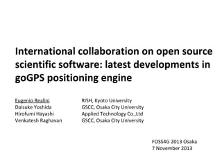
  • 2. GPS “raw data”(observations, orbits, …) If we have: - satellite positions - satellite-receiver distances - precise time 1 11 10 H e ig h t [ k m ] 32 24 28 8 we can estimate: - receiver position/velocity - atmospheric parameters -… 19 20 8 6 7 4 2 0 12 and we can do research: - positioning accuracy improvement - deformation monitoring - atmospheric water vapor retrieval -… 10 10 8 6 N o rth [k m ] 5 4 2 0 0 E a s t [k m ]
  • 3. From GPS to GNSS GPS is not the only positioning system available Other countries apart from US are building global (or regional) satellite systems GNSS Global Navigation Satellite System GLONASS BeiDou Russia China Global Galileo Europe QZSS Japan IRNSS India Regional
  • 4. GNSS “raw data”(observations, orbits, …) Standard consumer grade (low-cost) receiver: - GNSS observations are processed within the receiver - User can access only the processing result (e.g. coordinates) GNSS observations Coordinates and ancillary data Only visualization!
  • 5. GNSS “raw data”(observations, orbits, …) By accessing raw data, we can perform advanced analyses, e.g. - improving the positioning accuracy by relative positioning - study and monitor the atmosphere - … Raw data
  • 6. Receivers providing “raw data” GNSS receivers generally provide raw data formatted according to proprietary binary protocols. Often these protocols are available to customers (or even public). Almost all geodetic (survey grade) receivers (dual-frequency or single-frequency) ~ $3,000 – $30,000 A few low-cost (consumer grade) receivers (single-frequency) ~ $100 – $500
  • 7. Low-cost raw data logger prototype ENVLoggerRPi - developed at Osaka City University u-blox LEA-6T module (GPS raw data) environmental sensors (T, P, RH, CO2) logging data on microSD card Raspberry Pi (credit card-sized Linux computer) Power-over-Ethernet Configurable (text file on SD card) open source firmware
  • 8. GNSS processing software Commercial Academic GAMIT/GLOBK TGO/TTC (Trimble) LGO (Leica) Bernese RTNet Topcon Tools (Topcon) (GPS Solutions) Justin (JAVAD) Bold = source code provided GIPSY/OASIS II Java goGPS MATLAB RTKLIB/GpsTools gLAB Free and Open Source Software (FOSS)
  • 9. goGPS MATLAB - Real-time and post-processing - developed in MATLAB 7.6+ - works on both Windows and UNIX - GUIs available - single-frequency (L1) positioning
  • 10. goGPS MATLAB downloads (Apr 2009 – Oct 2013)
  • 12. goGPS international network (2012) Cryms http://www.cryms.com Note: institution/company names are only indicative of goGPS contributors’ affiliations, NOT official endorsements of the project Universidad de Jaén http://www.ujaen.es goGPS Polytechnic of Milan http://www.apptec.co.jp OSGEO JP http://www.polimi.it http://www.osgeo.jp GReD Osaka City University http://www.g-red.eu/ Galileian Plus Applied Technology http://www.galileianplus.it http://www.osaka-cu.ac.jp Volunteers (open source) Kyoto University (RISH) http://www.rish.kyoto-u.ac.jp
  • 13. Latest developments (during 2013) • EGNOS (SBAS) support code contributed by: Giuliano Sironi, Politecnico di Milano, Italy Antonio Herrera Olmo, Universidad de Jaén, Spain • Integer phase ambiguity resolution by LAMBDA method code contributed by: Hendy F. Suhandri, Universität Stuttgart, Germany Andrea Nardo, Curtin University, Australia • Multi-GNSS support (also by using low-cost receivers by NVS) GPS, GLONASS, Galileo, BeiDou, QZSS code contributed by: (myself), Kyoto University, Japan (with knowledge support from Andrea Nardo) Daisuke Yoshida, Osaka City University, Japan
  • 14. EGNOS (SBAS) support Accuracy improved to < 1 m in stand-alone mode (i.e. without a base station) SBAS: Satellite-Based Augmentation System (geostationary systems)
  • 15. Integer ambiguity resolution by LAMBDA method Static test results: •u-blox AEK-4T receiver (low-cost) •geodetic base station (~60 m baseline) Accuracy: < 1 cm Example application: deformation monitoring with multiple low-cost receivers
  • 16. Multi-GNSS support increased number of available satellites improved positioning capabilities, esp. in urban environments source: goGPS plot source: http://www.multignss.asia/campaign.html