

Recommended
More Related Content
What's hot
What's hot (20)
Viewers also liked
Viewers also liked (20)
Similar to Ocean circulation
Similar to Ocean circulation (20)
More from Dedy Aslam
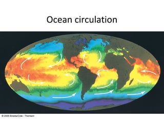
Ocean circulation
- 2. What are ocean currents? • Mass movement or flow of ocean water • Two types of major currents – Surface currents – Deep ocean currents / thermohaline circulation.
- 3. Surface currents • Surface currents move water horizontally – parallel to the Earth’s surface extend to approximately 100-150m depth (depending on strength of winds) • Two external forces influence the World Ocean generating ocean currents - gravitation and the energy flux from the sun. • Gravitation includes tidal forces resulting from the interaction of water mass with the moon and the sun, and rotation of the Earth.. • The radiation flux from the sun results in wind stress, heating and cooling of the ocean surface, and evaporation and precipitation of water. • A complex process of interaction between these forces results in a complex and variable pattern of ocean circulation
- 4. 1. What drives ocean currents? The amount of heat radiation is of maximum at the equator. The cold air at the poles is denser than the warm air at the equator; hence, air pressure at sea level is higher at the poles than at the equator. The high air pressure in the poles moves towards the equator. IoE 184 - The Basics of Satellite Oceanography. 1. The Basic Concepts of Oceanography
- 5. Current Generation • Wind acting on the surface of the water, causes a partial transfer of kinetic energy from the wind to the water. • Wind-driven currents decline with depth, and are generally limited by the permanent pycnocline – 100 to 200 m – but in some cases they may go as deep as 1000 m. • The southeast trades and the northeast trades cause a general westward current. • The westerlies cause a general eastward current. • Because of the continents, these currents are interrupted. A westward current becomes a southward current in the southern hemisphere, and a northward current in the northern hemisphere. • Eastward currents are forced to turn north in the southern hemisphere, and south in the northern hemisphere.
- 6. Winds on a NON-rotating earth flow north-south In fluid and gases pressure gradients produce flow from regions of high pressure to regions of low pressure. If the earth were not rotating, the response to these pressure gradients would be direct and simple. IoE 184 - The Basics of Satellite Oceanography. 1. The Basic Concepts of Oceanography
- 7. 1. What drives ocean currents? The rotation of the Earth modifies the pattern of atmospheric circulation. As air moves toward the equator, the rotation of the earth shifts ocean and land eastward under it. The result is "easterly" winds (Polar Easterlies and Trade winds). Traveling from the equator to the pole air in the upper atmospheric layer cools. About 30ºN and 30ºS the air becomes dense enough to fall back to earth surface, forming two Hadley cells of atmospheric circulation. Similar cells are created between the poles and 60º latitude. The zones between 30º and 60º are called Ferrel cells, where "westerly" winds dominate. IoE 184 - The Basics of Satellite Oceanography. 1. The Basic Concepts of Oceanography
- 8. Global wind pattern The global pattern of winds cause the major ocean currents in the surface layer.
- 9. The movement of water as influenced by the Coriolis Surface Currents effect and gravity. • Controlled by three factors – Global winds – Coriolis Effect – Continental Deflections Global Winds cause surface currents to flow in the direction the wind is blowing. The Coriolis effect is the shifting of winds and surface currents caused by Earth’s rotation. The Coriolis effect creates clock-wise gyre in northern hemisphere and anti- clockwise in southern hemisphere. Continental Deflections Shape of continents change the direction of current flow
- 10. Wind driven circulation • About 10% of the water is moved by surface currents • Surface Currents occur at upper 400 m. • The currents move above the pycnocline. • Surface currents are primarily driven by the wind and wind friction • Move fast relative to thermohaline circulation (1 to 2 m/s) • Reflect global wind patterns and Coriolis effect! • The pycnocline separates the surface layer from the deep thermohaline circulation.
- 11. Gyre Formation • Two great circular currents (gyres) are formed, one the northern hemisphere and one on the southern hemisphere, in both the Atlantic and the Pacific. winds • When the wind acts on water in the open ocean for a long time, the resultant currents are about 1-3% of the wind speed. • Ocean currents are massive. They can persist currents for long times, even if the winds are light or even against them.
- 12. Current gyres • Gyres are large circular-moving loops of water – Subtropical gyres • Five main gyres (one in each ocean basin): – North Pacific – South Pacific – North Atlantic – South Atlantic – Indian • Generally 4 currents in each gyre • Centered at about 30º north or south latitude
- 13. – Subpolar gyres • Smaller and fewer than subtropical gyres • Generally 2 currents in each gyre • Centered at about 60º north or south latitude • Rotate in the opposite direction of adjoining subtropical gyres
- 14. • Western boundary currents – These are narrow, deep, • fast currents found at the western boundaries of ocean basins. – The Gulf Stream – The Japan Current – The Brazil Current – The Agulhas Current – The Eastern Australian Current
- 15. • Eastern boundary currents – These currents are cold,shallow and broad, and their boundaries are not well defined – The Canary Current – The Benguela Current – The California Current – The West Australian Current – The Peru Current
- 16. Major Currents of the World Ocean
- 17. Ekman spiral • Wind flows over surface and creates drag on water • Wind driven flow is deflected to right in N hemisphere by Coriolis effect • Water flows at only about 3% of the speed of the driving wind. • Current flows at 45o to the right of the wind direction in the northern hemisphere • But, only the surface feels the wind • Each layer down only feels the layer above so is deflected based on the layer above • Each layer down moves more slowly than the layer above
- 18. •Wind creates a drag on surface waters and successive layers exert drag on each successive layer below. •Each layer is subject to Coriolis deflection
- 20. Ekman flow • Wind exerts frictional drag on water causing a thin layer of water to move – Transfer of momentum is not efficient; induced current is about 2% of wind speed – Coriolis force causes water to veer right or left of wind • As the surface layer of water begins to move, it exerts frictional drag on the layer below • And so on, each layer moving slower and deflected relative to the layer above • Produces a pattern of decreased speed with depth and increased angle between flow and wind direction with depth (Ekman spiral)
- 21. Flow in Ekman layer • Surface current typically 20-40o to wind direction • Average or net flow of water in Ekman layer is 90o to wind • Average or net flow in Ekman layer is the drift current • Thickness of Ekman layer is approximately 100m
- 22. Fig. 5-1
- 23. Coastal upwelling Northern hemisphere
- 24. Coastal downwelling Northern hemisphere
- 26. Pressure gradients develop in the ocean because the sea surface is warped into broad mounds and depressions with a relief of about one meter. • Mounds on the ocean’s surface are caused by converging currents, places where water sinks. • Depressions on the ocean;s surface are caused by diverging currents, places from where water rises. • Water flowing down pressure gradients on the ocean’s irregular surface are deflected by the Coriolis effect. The amount of deflection is a function of latitude and current speed.
- 27. In the center of gyres water piles up (converges) upper ~100 m Fig. 5-3 (a) Ekman spiral Fig. 5-3 (b) Ekman transport
- 28. Downwelling of water Creation of geostrophic currents as a result of the pressure gradient Upwelling of deep water to replace surface water in areas of divergence - e.g., along the equator
- 29. Consequences of Ekman transport • At the center of the gyres: – Convergence – Water tends to pile up • Convergence is associated with downwelling • At the edge of continents, divergence occurs • Divergence is associated with upwelling
- 30. Consequences of Ekman transport, Coriolis, and gravity • Ekman transport causes water to pile up in the middle of gyres • Gravity then acts to force it down • Coriolis act in the opposite direction as gravity • The forces balance, and flow tends to occur parallel to the topographic contours • This is called geostrophic flow
- 31. Geostrophy – a frictionless balance between the pressure gradient And the Coriolis acceleration – generates currents that move Around the ‘hill’
- 32. Measured average topography of the North Atlantic (red-high)
- 33. Permanent convergences and divergences Convergences - downwelling – 5 major permanent zones of convergence ∼ tropical convergence at equator ∼ N. subtropical convergence –30° to 40° N and S ∼ S. subtropical convergence –mark the center of the gyres ∼ Antarctic convergence at 50º S ∼ Arctic convergence at 50º N Divergences - upwelling – 3 major permanent zones of divergence ∼ N. tropical divergence ∼ S. tropical divergence ∼ Antarctic divergence
- 34. Upwelling and downwelling • Vertical movement of water – Upwelling = movement of deep water to surface • Brings cold, nutrient-rich water to surface • Produces high productivities and abundant marine life – Downwelling = movement of surface water down • Moves warm, nutrient-depleted surface water down
- 35. Review of horizontal wind driven circulation upwelling downwelling downwelling upwelling downwelling downwelling upwelling
- 37. Areas of upwelling – coastal upwelling has seasonality (as do winds)
- 39. May global wind induced upwelling
- 40. Deep-Ocean Circulation • Throughout most of the oceans, the layers form three principle zones: the surface zone ( the mixed layer), the pycnocline zone, and the deep zone. • Deep ocean currents are known as thermohaline circulation • Thermohaline circulation is a density driven flow of water generated by differences in salinity or temperature. • Water at the surface is exposed to changes in salinity through evaporation or precipitation and in temperature through cooling or heating. • Based upon depth, surface water masses can be broadly classified as Central waters (from 0 to 1 km), Intermediate waters (from 1 to 2 km), and Deep and bottom waters (greater than 2 km).
- 41. • Once water sinks and becomes isolated from the atmosphere, its salinity and temperature are largely set for an extended period of time up to 1000 years. • In the polar/subpolar regions the climate is cold and the sea-water is frozen. When the water freeze only pure water turns into ice and increases the salinity and density. • The major thermohaline currents form the high density water sink in the polar or subpolar regions and flow mainly equatorward, their outward flow is confined between the continents. • Thermohaline circulation occurs below the pycnocline • It involves 90% of all ocean water • It moves slowly
- 42. Density of surface waters Pacific Deep North Atlantic Waters Deep Waters Antarctic Intermediate Antarctic Waters Bottom Waters
- 43. Buoyancy driven circulation Precipitation Evaporation Precipitation Evaporation (cold winds) Heating Cooling Dense water sinks
- 44. Vertical section of the Atlantic North Pole South Pole
- 45. • The Atlantic Ocean has the most complex ocean stratification containing the following layers: Antarctic Bottom Water, Antarctic Deep Water, North Atlantic Deep Water, Arctic Intermediate Water, and Mediterranean Intermediate Water.
- 46. Atlantic Ocean subsurface water masses
- 47. Pacific Ocean • The Pacific Ocean has a less complex stratification, is weakly layered, displays sluggish circulation and is remarkably uniform below 2000m Indian Ocean • The Indian Ocean has the simplest stratification consisting of Common Water, Antarctic Intermediate Water, and Red Sea Intermediate Water.
- 48. Labeling the world oceans Water Masses TS Diagrams
- 49. SUMMARY of Water Masses in the Atlantic • AABW densest and deepest Sea ice forms ==> salt • NADW second, fills most of deep Atlantic Salty water moving north • MOW saltiest but not as dense - sits with other water masses at medium depths Evaporation ==> VERY salty
- 50. Review of horizontal wind driven circulation Vertical section
- 51. A model of the vertical overturning circulation
- 52. REGIONAL TYPES CIRCULATION Anti-estuarine and estuarine circulation in basins with excess evaporation and with excess precipitation, respectively, The arid basin (A) is characterized by downwelling, hence low fertility and high oxygen content. The estuarine basin (B) is characterized by upwelling and salinity stratification, hence high fertility and low oxygen content. The geographic names above the graph give three examples each for anti- estuarine and estuarine circulation Fig.7.12 Anti-estuarine and estuarine circulation in basins with excess evaporation and with excess precipitation, respectively, The arid basin (A) is characterized by downwelling, hence low fertility and high oxygen content. The estuarine basin (B) is characterized by upwelling and salinity stratification, hence high fertility and low oxygen content. The geographic names above the graph give three examples each for anti-estuarine and estuarine circulation
- 53. Estuary Types Circulation • Where river flow is strong, and tidal currents weak, salt- wedge type estuaries are favored • A partially mixed estuary where river flow and tidal mixing are about equal. Most estuaries are of this type. Low density water mass flow toward the sea and the high density water flow towards the land Estuary circulations are found in the humid areas: fjiord and estuary.
- 54. Anti-estuary circulation • Mediterranean type circulation • High salinity water mass as a result of evaporation in isolated sea. • High salinity water mass flows outwards to open ocean and the low density water from open ocean flow into the isolated sea. • For example: Mediterranea- Gibraltar- Atlantic Persian Gulf- Hormuz Strait- Indian Ocean Red Sea – Bab el Mandeb- Indian Ocean
- 55. The outflow of Mediterranean Water