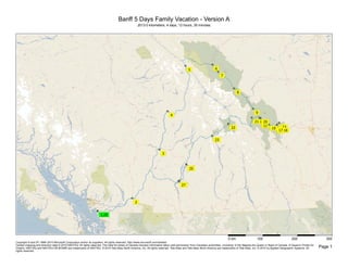
(Strip Maps) Banff 5 Days Family Vacation - Version A
- 1. Banff 5 Days Family Vacation - Version A
2013.0 kilometers; 4 days, 12 hours, 35 minutes
0 km 100 200 300
Copyright © and (P) 1988–2010 Microsoft Corporation and/or its suppliers. All rights reserved. http://www.microsoft.com/streets/
Certain mapping and direction data © 2010 NAVTEQ. All rights reserved. The Data for areas of Canada includes information taken with permission from Canadian authorities, including: © Her Majesty the Queen in Right of Canada, © Queen's Printer for
Ontario. NAVTEQ and NAVTEQ ON BOARD are trademarks of NAVTEQ. © 2010 Tele Atlas North America, Inc. All rights reserved. Tele Atlas and Tele Atlas North America are trademarks of Tele Atlas, Inc. © 2010 by Applied Geographic Systems. All Page 1
rights reserved.
- 2. DAY 1
7:00 AM 0.0 km 1 Depart White Rock on Merklin St (North) for 0.8
km
7:01 AM 0.8 km Turn RIGHT (East) onto 16 Ave [N Bluff Rd] for 4.5
km
7:07 AM 5.3 km Keep STRAIGHT onto 16 Ave for 6.4 km
7:14 AM 11.8 km Keep STRAIGHT onto 16 Ave [N Bluff Rd] for 0.8 km
7:15 AM 12.5 km Keep STRAIGHT onto 16 Ave for 10.5 km
7:25 AM 23.0 km Turn LEFT (North) onto Hwy-13 [264 St] for 3.1 km
7:28 AM 26.2 km Turn RIGHT (East) onto Hwy-1A [Fraser Hwy] for 8.3
km
7:37 AM 34.5 km Take Ramp (RIGHT) onto TC-1 [Trans Canada Hwy]
for 87.0 km towards HWY-1 E / Hope
8:32 AM 121.6 km At exit 170, keep RIGHT onto Ramp for 0.3 km
towards HWY-1 E / Trans Canada Hwy East / Cache
Creek / Hope / Prince George
8:32 AM 121.9 km Keep LEFT to stay on Ramp for 70 m towards HWY-1
/ Trans Canada Hwy / Kamloops / Cache Creek /
Town Centre
8:33 AM 121.9 km Bear LEFT (North-East) onto TC-1 [Flood-Hope Rd]
for 0.9 km
8:34 AM 122.9 km Turn RIGHT (East) onto Wallace St for 0.4 km
8:35 AM 123.2 km 2 Arrive Memorial Park, Hope
9:20 AM 123.2 km Depart Memorial Park, Hope on Wallace St (East) for
0.4 km
9:20 AM 123.6 km Turn RIGHT (South) onto 6th Ave for 0.6 km
9:22 AM 124.2 km Turn LEFT (East) onto Kawkawa Lake Rd for 2.8 km
9:25 AM 127.1 km Turn RIGHT (South) onto Othello Rd for 6.3 km
9:30 AM 133.3 km Road name changes to Local road(s) for 90 m
9:30 AM 133.4 km Turn RIGHT (East) onto Local road(s) for 0.4 km
9:31 AM 133.8 km Bear LEFT (West) onto Local road(s) for 30 m
9:31 AM 133.8 km Take Ramp (RIGHT) onto Hwy-5 [Coquihalla Hwy] for
185.6 km towards HWY-5 N
11:11 AM 319.5 km At exit 368, keep RIGHT onto Ramp for 0.1 km
towards HWY-5A S / Hillside Ave. / Merritt
0 km 50
Copyright © and (P) 1988–2010 Microsoft Corporation and/or its suppliers. All rights reserved. http://www.microsoft.com/streets/
Certain mapping and direction data © 2010 NAVTEQ. All rights reserved. The Data for areas of Canada includes information taken with permission from Canadian authorities, including: © Her Majesty the Queen in Right of Canada, © Queen's Printer for
Ontario. NAVTEQ and NAVTEQ ON BOARD are trademarks of NAVTEQ. © 2010 Tele Atlas North America, Inc. All rights reserved. Tele Atlas and Tele Atlas North America are trademarks of Tele Atlas, Inc. © 2010 by Applied Geographic Systems. All Page 2
rights reserved.
- 3. 11:11 AM 319.6 km Turn LEFT (North) onto Hwy-5A [Hillside Way] for 0.1
km
11:11 AM 319.7 km Road name changes to Hillside Way for 0.1 km
11:12 AM 319.8 km Turn LEFT (West) onto Trans Canada Hwy W for 40
m
11:12 AM 319.9 km 3 Arrive Aberdeen Mall, Kamloops
12:42 PM 319.9 km Depart Aberdeen Mall, Kamloops on Local road(s)
(East) for 50 m
12:43 PM 319.9 km Bear RIGHT (South) onto Hillside Way for 0.1 km
12:43 PM 320.0 km Road name changes to Hwy-5A [Hillside Way] for 0.1
km
12:44 PM 320.2 km Take Ramp (LEFT) onto Hwy-5 [Hwy-97] for 5.0 km
towards HWY-97 / HWY-1 / Trans Canada Hwy /
Salmon Arm / City Centre
12:48 PM 325.1 km At exit 374, keep RIGHT onto Ramp for 0.7 km
towards HWY-5 N / Jasper
12:48 PM 325.8 km Road name changes to Hwy-5 [Yellowhead Hwy] for
123.2 km
1:59 PM 418.8 km Refuel before here (last refuel was 418.8 kilometers
ago)
2:19 PM 449.0 km Turn LEFT (North) onto Clearwater Valley Rd for 0.2
km
2:20 PM 449.2 km 4 Arrive Near Spahats Creek Falls
3:20 PM 449.2 km Depart Near Spahats Creek Falls on Clearwater
Valley Rd (South) for 0.2 km
3:20 PM 449.4 km Turn LEFT (East) onto Hwy-5 [Yellowhead Hwy] for
195.7 km
5:28 PM 645.1 km 5 Arrive Ramada Hotel, Valemount
** Arrival earlier than specified 6:00 PM arrival time **
End of day
DAY 2
7:30 AM 645.1 km Depart Ramada Hotel, Valemount on Hwy-5
[Yellowhead Hwy] (North) for 19.3 km
Check your departure time; the next stop is in a
different time zone.
0 km 20 40 60 80
Copyright © and (P) 1988–2010 Microsoft Corporation and/or its suppliers. All rights reserved. http://www.microsoft.com/streets/
Certain mapping and direction data © 2010 NAVTEQ. All rights reserved. The Data for areas of Canada includes information taken with permission from Canadian authorities, including: © Her Majesty the Queen in Right of Canada, © Queen's Printer for
Ontario. NAVTEQ and NAVTEQ ON BOARD are trademarks of NAVTEQ. © 2010 Tele Atlas North America, Inc. All rights reserved. Tele Atlas and Tele Atlas North America are trademarks of Tele Atlas, Inc. © 2010 by Applied Geographic Systems. All Page 3
rights reserved.
- 4. 7:43 AM 664.4 km Bear RIGHT (East) onto TC-16 [Trans Canada Hwy]
for 101.3 km
8:32 AM 741.0 km Entering Alberta
8:53 AM 765.7 km Turn RIGHT (South) onto Hwy-93 [Icefields Pkwy] for
1.8 km
8:55 AM 767.5 km Turn RIGHT (West) onto Local road(s) for 0.7 km
8:56 AM 768.2 km Bear RIGHT (West) onto Local road(s) for 2.4 km
8:57 AM 770.6 km Bear RIGHT (West) onto Local road(s) for 0.8 km
Check local time; this stop is in a different time zone.
9:00 AM 771.4 km Bear LEFT (South-West) onto Local road(s) for 30 m
9:00 AM 771.4 km 6 Arrive Jasper Tramway
11:00 AM 771.4 km Depart Jasper Tramway on Local road(s) (North-East)
for 30 m
11:00 AM 771.4 km Bear RIGHT (East) onto Local road(s) for 0.8 km
11:02 AM 772.2 km Bear LEFT (East) onto Local road(s) for 2.4 km
11:04 AM 774.6 km Bear LEFT (East) onto Local road(s) for 0.7 km
11:05 AM 775.3 km Turn RIGHT (South) onto Hwy-93 [Icefields Pkwy] for
4.9 km
11:10 AM 780.2 km Turn RIGHT (South-West) onto Hwy-93A for 23.7 km
11:28 AM 803.9 km Turn LEFT (West) onto Local road(s) for 0.1 km
11:29 AM 804.1 km 7 Arrive Athabasca Falls
12:29 PM 804.1 km Depart Athabasca Falls on Local road(s) (East) for
0.1 km
12:29 PM 804.2 km Turn LEFT (North-East) onto Hwy-93A for 0.3 km
12:30 PM 804.5 km Turn RIGHT (South) onto Hwy-93 [Icefields Pkwy] for
71.6 km
1:08 PM 853.4 km Refuel before here (last refuel was 434.6 kilometers
ago)
1:29 PM 876.1 km Turn LEFT (North) onto Local road(s) for 50 m
1:29 PM 876.1 km 8 Arrive Columbia Icefield Tour
4:29 PM 876.1 km Depart Columbia Icefield Tour on Local road(s)
(South) for 40 m
0 km 20 40 60
Copyright © and (P) 1988–2010 Microsoft Corporation and/or its suppliers. All rights reserved. http://www.microsoft.com/streets/
Certain mapping and direction data © 2010 NAVTEQ. All rights reserved. The Data for areas of Canada includes information taken with permission from Canadian authorities, including: © Her Majesty the Queen in Right of Canada, © Queen's Printer for
Ontario. NAVTEQ and NAVTEQ ON BOARD are trademarks of NAVTEQ. © 2010 Tele Atlas North America, Inc. All rights reserved. Tele Atlas and Tele Atlas North America are trademarks of Tele Atlas, Inc. © 2010 by Applied Geographic Systems. All Page 4
rights reserved.
- 5. 4:30 PM 876.2 km Turn LEFT (East) onto Hwy-93 [Icefields Pkwy] for
90.3 km
5:48 PM 966.4 km Turn RIGHT (South-West) onto Local road(s) for 0.4
km
5:50 PM 966.8 km Bear LEFT (South) onto Local road(s) for 0.8 km
5:51 PM 967.6 km 9 Arrive Bow Lake
6:21 PM 967.6 km Depart Bow Lake on Local road(s) (North) for 0.8 km
6:23 PM 968.3 km Bear RIGHT (North) onto Local road(s) for 0.4 km
6:24 PM 968.7 km Turn RIGHT (East) onto Hwy-93 [Icefields Pkwy] for
35.4 km
6:52 PM 1004.1 km Keep RIGHT onto Ramp for 0.4 km towards HWY-1 /
SR-1 / Trans Canada Hwy East / Lake Louise
6:52 PM 1004.5 km Road name changes to Hwy-93 [TC-1] for 2.3 km
6:54 PM 1006.8 km Bear RIGHT (South) onto Ramp for 0.3 km towards
Bow Valley Parkway / Promenade de la Vallee Bow /
Lake Louise / Lac Louise
6:54 PM 1007.2 km Turn RIGHT (West) onto Chemin Lake Louise [Lake
Louise Dr] for 4.0 km
7:01 PM 1011.2 km 10 Arrive Fairmont Chateau Lake Louise [111 Lake
Louise Dr, Lake Louise AB T0L, Canada, Tel: +1
(403) 522-3511]
** Warning: Missed 7:00 PM arrival time **
End of day
DAY 3
10:30 AM 1011.2 km Depart Fairmont Chateau Lake Louise [111 Lake
Louise Dr, Lake Louise AB T0L, Canada, Tel: +1 (403)
522-3511] on Chemin Lake Louise [Lake Louise Dr]
(East) for 1.8 km
10:32 AM 1013.0 km Turn RIGHT (South) onto Moraine Lake Rd for 12.2
km
10:50 AM 1025.2 km Road name changes to Local road(s) for 0.8 km
10:51 AM 1026.0 km 11 Arrive Moraine Lake
11:31 AM 1026.0 km Depart Moraine Lake on Local road(s) (North) for 0.8
km
11:33 AM 1026.8 km Road name changes to Moraine Lake Rd for 12.2 km
0 km 10 20 30
Copyright © and (P) 1988–2010 Microsoft Corporation and/or its suppliers. All rights reserved. http://www.microsoft.com/streets/
Certain mapping and direction data © 2010 NAVTEQ. All rights reserved. The Data for areas of Canada includes information taken with permission from Canadian authorities, including: © Her Majesty the Queen in Right of Canada, © Queen's Printer for
Ontario. NAVTEQ and NAVTEQ ON BOARD are trademarks of NAVTEQ. © 2010 Tele Atlas North America, Inc. All rights reserved. Tele Atlas and Tele Atlas North America are trademarks of Tele Atlas, Inc. © 2010 by Applied Geographic Systems. All Page 5
rights reserved.
- 6. 11:50 AM 1039.0 km Turn RIGHT (East) onto Chemin Lake Louise [Lake
Louise Dr] for 2.2 km
11:55 AM 1041.1 km Take Ramp (RIGHT) onto Hwy-93 [TC-1] for 25.0 km
towards HWY-1 E / HWY-93 S / Trans Canada Hwy
East / Radium Hot Springs / Banff / Sources
Thermales Radium
12:14 PM 1066.1 km Road name changes to TC-1 [Trans Canada Hwy] for
33.9 km
12:39 PM 1100.0 km Keep RIGHT onto Ramp for 0.2 km towards Banff
12:40 PM 1100.2 km Keep LEFT to stay on Ramp for 90 m
12:40 PM 1100.3 km Turn LEFT (North) onto Banff Ave for 0.5 km
12:40 PM 1100.8 km Road name changes to Minnewanka Loop for 6.6 km
12:51 PM 1107.4 km Turn RIGHT (South-East) onto Local road(s) for 80 m
12:51 PM 1107.5 km Turn RIGHT (South) onto Local road(s) for 0.5 km
12:52 PM 1108.0 km 12 Arrive Two Jack Lake
1:22 PM 1108.0 km Depart Two Jack Lake on Local road(s) (North) for
0.5 km
1:23 PM 1108.4 km Turn LEFT (West) onto Local road(s) for 80 m
1:24 PM 1108.5 km Turn RIGHT (East) onto Minnewanka Loop for 0.9 km
1:26 PM 1109.5 km Turn RIGHT (East) onto Local road(s) for 6.9 km
1:39 PM 1116.4 km 13 Arrive Lake Minnewanka
2:09 PM 1116.4 km Depart Lake Minnewanka on Local road(s) (West) for
6.9 km
2:22 PM 1123.3 km Turn RIGHT (North-West) onto Minnewanka Loop for
6.8 km
2:32 PM 1130.1 km Road name changes to Banff Ave for 5.2 km
2:40 PM 1135.4 km Turn LEFT (East) onto Buffalo St for 1.3 km
2:43 PM 1136.6 km Bear RIGHT (South-East) onto Local road(s) for 30 m
2:43 PM 1136.7 km 14 Arrive Tunnel Mountain Road
5:13 PM 1136.7 km Depart Tunnel Mountain Road on Local road(s)
(North-West) for 30 m
5:13 PM 1136.7 km Bear LEFT (West) onto Buffalo St for 1.3 km
5:15 PM 1138.0 km Turn LEFT (South) onto Banff Ave for 0.3 km
0 km 10 20
Copyright © and (P) 1988–2010 Microsoft Corporation and/or its suppliers. All rights reserved. http://www.microsoft.com/streets/
Certain mapping and direction data © 2010 NAVTEQ. All rights reserved. The Data for areas of Canada includes information taken with permission from Canadian authorities, including: © Her Majesty the Queen in Right of Canada, © Queen's Printer for
Ontario. NAVTEQ and NAVTEQ ON BOARD are trademarks of NAVTEQ. © 2010 Tele Atlas North America, Inc. All rights reserved. Tele Atlas and Tele Atlas North America are trademarks of Tele Atlas, Inc. © 2010 by Applied Geographic Systems. All Page 6
rights reserved.
- 7. 5:16 PM 1138.2 km Turn LEFT (East) onto Mountain Ave for 0.2 km
5:17 PM 1138.4 km Bear LEFT (South-East) onto Spray Ave for 0.9 km
5:19 PM 1139.3 km Turn LEFT (East) onto Local road(s) for 0.1 km
5:19 PM 1139.4 km 15 Arrive Bow Fall + Fairmont-Banff Springs [Banff
AB T1L, Canada, Tel: +1 (403) 762-2211]
6:19 PM 1139.4 km Depart Bow Fall + Fairmont-Banff Springs [Banff AB
T1L, Canada, Tel: +1 (403) 762-2211] on Local
road(s) (North) for 0.1 km
6:19 PM 1139.5 km Turn RIGHT (North-West) onto Spray Ave for 0.9 km
6:21 PM 1140.3 km Bear RIGHT (North) onto Mountain Ave for 0.2 km
6:22 PM 1140.5 km Turn RIGHT (North) onto Banff Ave for 1.4 km
6:25 PM 1141.9 km 16 At The Fox Hotel & Suites in Banff (Check-in),
stay on Banff Ave (East) for 0.7 km
** Warning: Missed 5:30 PM arrival time **
6:26 PM 1142.6 km 17 At Banff National Park, stay on Banff Ave (West)
for 0.7 km
6:27 PM 1143.4 km 18 Arrive The Fox Hotel
** Arrival earlier than specified 9:30 PM arrival time **
End of day
DAY 4
7:00 AM 1143.4 km Depart The Fox Hotel on Banff Ave (West) for 0.6 km
7:00 AM 1143.9 km Turn RIGHT (West) onto Elk St for 0.5 km
7:02 AM 1144.4 km Road name changes to Railway Ave for 0.2 km
7:02 AM 1144.6 km Turn RIGHT (North) onto Mt Norquay Rd for 1.0 km
7:04 AM 1145.6 km Take Ramp (LEFT) onto TC-1 [Trans Canada Hwy] for
5.5 km towards HWY-1 / Trans Canada Hwy / Lake
Louise
7:08 AM 1151.1 km Keep RIGHT onto Ramp for 0.3 km towards HWY-1A
/ Promenade de la Vallée Bow / Bow Valley Parkway
7:09 AM 1151.4 km Bear RIGHT (North-West) onto Hwy-1A [Bow Valley
Pkwy] for 17.6 km
7:26 AM 1169.0 km Turn RIGHT (North-East) onto Local road(s) for 20 m
7:27 AM 1169.0 km Bear LEFT (North) onto Local road(s) for 30 m
0 km 2 4 6 8 10
Copyright © and (P) 1988–2010 Microsoft Corporation and/or its suppliers. All rights reserved. http://www.microsoft.com/streets/
Certain mapping and direction data © 2010 NAVTEQ. All rights reserved. The Data for areas of Canada includes information taken with permission from Canadian authorities, including: © Her Majesty the Queen in Right of Canada, © Queen's Printer for
Ontario. NAVTEQ and NAVTEQ ON BOARD are trademarks of NAVTEQ. © 2010 Tele Atlas North America, Inc. All rights reserved. Tele Atlas and Tele Atlas North America are trademarks of Tele Atlas, Inc. © 2010 by Applied Geographic Systems. All Page 7
rights reserved.
- 8. 7:27 AM 1169.0 km 19 Arrive Johnston Canyon (51.24621°N
115.84147°W)
8:57 AM 1169.0 km Depart Johnston Canyon (51.24621°N 115.84147°W)
on Local road(s) (South) for 30 m
8:57 AM 1169.0 km Bear RIGHT (South-West) onto Local road(s) for 20
m
8:58 AM 1169.1 km Turn RIGHT (North-West) onto Hwy-1A [Bow Valley
Pkwy] for 7.3 km
9:06 AM 1176.3 km Turn RIGHT (North-West) onto Ramp for 0.4 km
towards SR-1 W / HWY-1 W / Trans Canada Hwy
West / Lake Louise
9:06 AM 1176.7 km Road name changes to Hwy-93 [TC-1] for 24.6 km
9:24 AM 1201.3 km Keep RIGHT onto Ramp for 0.5 km towards
Promenade de la Vallee Bow / Bow Valley Parkway /
Lac Louise / Lake Louise
9:25 AM 1201.8 km 20 Arrive Lake Louise Ski Area
10:55 AM 1201.8 km Depart Lake Louise Ski Area on Ramp (North) for 0.4
km towards HWY-93 N / HWY-1 W / Trans Canada
Hwy West / Field / Jasper
10:55 AM 1202.2 km Merge onto Hwy-93 [TC-1] for 2.3 km
10:57 AM 1204.5 km Road name changes to TC-1 [Trans Canada Hwy] for
24.6 km
11:02 AM 1211.3 km Entering British Columbia
11:16 AM 1229.1 km Turn RIGHT (West) onto Local road(s) for 9.9 km
11:24 AM 1239.0 km 21 Arrive Emerald Lake
12:24 PM 1239.0 km Depart Emerald Lake on Local road(s) (West) for 9.9
km
Check your departure time; the next stop is in a
different time zone.
12:33 PM 1248.9 km Turn RIGHT (South) onto TC-1 [Trans Canada Hwy]
for 131.1 km
1:00 PM 1281.1 km Refuel before here (last refuel was 427.8 kilometers
ago)
Check local time; this stop is in a different time zone.
2:16 PM 1380.0 km Turn LEFT (South-East) onto Local road(s) for 90 m
0 km 20 40 60
Copyright © and (P) 1988–2010 Microsoft Corporation and/or its suppliers. All rights reserved. http://www.microsoft.com/streets/
Certain mapping and direction data © 2010 NAVTEQ. All rights reserved. The Data for areas of Canada includes information taken with permission from Canadian authorities, including: © Her Majesty the Queen in Right of Canada, © Queen's Printer for
Ontario. NAVTEQ and NAVTEQ ON BOARD are trademarks of NAVTEQ. © 2010 Tele Atlas North America, Inc. All rights reserved. Tele Atlas and Tele Atlas North America are trademarks of Tele Atlas, Inc. © 2010 by Applied Geographic Systems. All Page 8
rights reserved.
- 9. 2:17 PM 1380.1 km 22 Arrive Rogers Pass
2:37 PM 1380.1 km Depart Rogers Pass on Local road(s) (North-West)
for 90 m
2:37 PM 1380.2 km Turn LEFT (South-West) onto TC-1 [Trans Canada
Hwy] for 65.6 km
3:28 PM 1445.8 km Turn LEFT (South-West) onto Townley St for 0.8 km
3:30 PM 1446.6 km Turn RIGHT (North-West) onto Local road(s) for 0.5
km
3:31 PM 1447.1 km Road name changes to Tamarac St for 0.3 km
3:32 PM 1447.4 km Road name changes to Track St (E) for 1.2 km
3:35 PM 1448.5 km 23 Arrive Revelstoke Railway Museum [719 Track St
W, Revelstoke BC V0E, Canada, Tel: +1 (250)
837-6060]
4:35 PM 1448.5 km Depart Revelstoke Railway Museum [719 Track St W,
Revelstoke BC V0E, Canada, Tel: +1 (250) 837-6060]
on Track St W (North) for 0.3 km
4:35 PM 1448.8 km Turn LEFT (South-West) onto Long Ave, then
immediately turn RIGHT (North-West) onto Victoria
Rd W for 1.4 km
4:38 PM 1450.1 km Turn LEFT (South-West) onto Hwy-23 [TC-1] for 1.0
km
4:40 PM 1451.1 km Keep STRAIGHT onto TC-1 [Trans Canada Hwy] for
69.7 km
5:29 PM 1520.8 km Turn LEFT (South) onto Hwy-97A for 28.2 km
5:52 PM 1549.0 km Turn LEFT (South) onto Enderby-Grindrod Rd for 9.1
km
5:59 PM 1558.1 km Bear RIGHT (West) onto Enderby-Mabel Lake Rd for
10 m
6:00 PM 1558.1 km Road name changes to Cliff Ave for 0.5 km
6:01 PM 1558.6 km Turn LEFT (South) onto Hwy-97A [George St] for 26.5
km
6:22 PM 1585.1 km Road name changes to Hwy-97 for 8.9 km
6:30 PM 1594.0 km 24 Arrive Best Western (3914 32nd St, Vernon BC)
** Arrival earlier than specified 7:00 PM arrival time **
End of day
0 km 20 40 60
Copyright © and (P) 1988–2010 Microsoft Corporation and/or its suppliers. All rights reserved. http://www.microsoft.com/streets/
Certain mapping and direction data © 2010 NAVTEQ. All rights reserved. The Data for areas of Canada includes information taken with permission from Canadian authorities, including: © Her Majesty the Queen in Right of Canada, © Queen's Printer for
Ontario. NAVTEQ and NAVTEQ ON BOARD are trademarks of NAVTEQ. © 2010 Tele Atlas North America, Inc. All rights reserved. Tele Atlas and Tele Atlas North America are trademarks of Tele Atlas, Inc. © 2010 by Applied Geographic Systems. All Page 9
rights reserved.
- 10. DAY 5
10:00 AM 1594.0 km Depart Best Western (3914 32nd St, Vernon BC) on
39th Ave (East) for 0.5 km
10:00 AM 1594.5 km Turn RIGHT (South) onto 27th St for 0.7 km
10:02 AM 1595.2 km 25 Arrive Justice Park, Vernon BC
10:42 AM 1595.2 km Depart Justice Park, Vernon BC on 30th Ave (West)
for 0.3 km
10:42 AM 1595.5 km Turn LEFT (South) onto 30th St for 0.3 km
10:43 AM 1595.8 km Turn RIGHT (West) onto Hwy-6 [25th Ave] for 0.2 km
10:44 AM 1596.0 km Turn LEFT (South) onto Hwy-97 [32nd St] for 57.2 km
11:35 AM 1653.2 km Turn LEFT (South) onto Boucherie Rd for 4.0 km
11:41 AM 1657.2 km 26 Arrive Qyails' Gate (Winery Restaurant)
12:56 PM 1657.2 km Depart Qyails' Gate (Winery Restaurant) on
Boucherie Rd (South-West) for 0.7 km
12:57 PM 1657.9 km Turn RIGHT (West) onto Mission Hill Rd for 1.1 km
12:59 PM 1659.0 km 27 Arrive Mission Hill Family Estate Winery (Winery
Tour)
3:44 PM 1659.0 km Depart Mission Hill Family Estate Winery (Winery
Tour) on Ridge Blvd (North-West) for 0.7 km
3:45 PM 1659.7 km Turn LEFT (West) onto Vineyard Dr for 0.5 km
3:47 PM 1660.2 km Turn RIGHT (North) onto E Boundary Rd for 1.1 km
3:49 PM 1661.3 km Turn LEFT (West) onto Daimler Dr for 0.5 km
3:50 PM 1661.8 km Turn LEFT (South) onto Hwy-97 [Hwy-97 S] for 7.5
km
3:57 PM 1669.3 km Keep RIGHT onto Ramp for 0.8 km towards
HWY-97C W / Merritt / Kamloops / Hope
3:58 PM 1670.1 km Road name changes to Hwy-97C [Okanagan Conn]
for 81.4 km
4:11 PM 1694.2 km Refuel before here (last refuel was 413.1 kilometers
ago)
4:41 PM 1751.6 km Keep STRAIGHT onto Hwy-5A [Hwy-97C] for 23.7 km
4:58 PM 1775.2 km Take Ramp (LEFT) onto Hwy-5 [Coquihalla Hwy] for
109.4 km towards HWY-5 TOLL
0 km 20 40 60 80
Copyright © and (P) 1988–2010 Microsoft Corporation and/or its suppliers. All rights reserved. http://www.microsoft.com/streets/
Certain mapping and direction data © 2010 NAVTEQ. All rights reserved. The Data for areas of Canada includes information taken with permission from Canadian authorities, including: © Her Majesty the Queen in Right of Canada, © Queen's Printer for
Ontario. NAVTEQ and NAVTEQ ON BOARD are trademarks of NAVTEQ. © 2010 Tele Atlas North America, Inc. All rights reserved. Tele Atlas and Tele Atlas North America are trademarks of Tele Atlas, Inc. © 2010 by Applied Geographic Systems. All Page 10
rights reserved.
- 11. 5:58 PM 1884.7 km At exit 177, road name changes to Hwy-3 [Crowsnest
Hwy] for 6.5 km towards HWY-3 W / Vancouver /
Hope
6:02 PM 1891.2 km Road name changes to TC-1 [Trans Canada Hwy] for
86.5 km
6:57 PM 1977.7 km At exit 83, keep RIGHT onto Ramp for 0.3 km
towards Fraser Hwy / Mt Lehman Rd / Abbotsford
Airport
6:57 PM 1978.0 km Take Ramp (LEFT) onto Hwy-1A [Fraser Hwy] for 8.8
km towards Fraser Hwy West / Abbotsford Airport
7:06 PM 1986.8 km Turn LEFT (South) onto Hwy-13 [264 St] for 3.1 km
7:09 PM 1990.0 km Turn RIGHT (West) onto 16 Ave for 10.5 km
7:20 PM 2000.5 km Keep STRAIGHT onto 16 Ave [N Bluff Rd] for 0.8 km
7:20 PM 2001.3 km Keep STRAIGHT onto 16 Ave for 6.4 km
7:28 PM 2007.7 km Keep STRAIGHT onto 16 Ave [N Bluff Rd] for 4.5 km
7:33 PM 2012.2 km Turn LEFT (South) onto Merklin St for 0.8 km
7:35 PM 2013.0 km 28 Arrive White Rock
** Arrival earlier than specified 8:00 PM arrival time **
0 km 20 40
Copyright © and (P) 1988–2010 Microsoft Corporation and/or its suppliers. All rights reserved. http://www.microsoft.com/streets/
Certain mapping and direction data © 2010 NAVTEQ. All rights reserved. The Data for areas of Canada includes information taken with permission from Canadian authorities, including: © Her Majesty the Queen in Right of Canada, © Queen's Printer for
Ontario. NAVTEQ and NAVTEQ ON BOARD are trademarks of NAVTEQ. © 2010 Tele Atlas North America, Inc. All rights reserved. Tele Atlas and Tele Atlas North America are trademarks of Tele Atlas, Inc. © 2010 by Applied Geographic Systems. All Page 11
rights reserved.
- 12. Route summary
Total journey cost $279.40
Driving distance 2013.0 kilometers
Trip duration 4 days, 12 hours, 35 minutes
Driving time 1 day, 2 hours, 8 minutes
Crow's flight distance between all stops 1513.7 kilometers
Route segment details
From To Method Distance Driving time
White Rock Memorial Park, Hope Quickest 123.2 kilometers 1 hour, 35 minutes
Memorial Park, Hope Aberdeen Mall, Kamloops Quickest 196.7 kilometers 1 hour, 52 minutes
Aberdeen Mall, Kamloops Near Spahats Creek Falls Quickest 129.3 kilometers 1 hour, 37 minutes
Near Spahats Creek Falls Ramada Hotel, Valemount Quickest 195.9 kilometers 2 hours, 8 minutes
Ramada Hotel, Valemount Jasper Tramway Quickest 126.3 kilometers 1 hour, 30 minutes
Jasper Tramway Athabasca Falls Quickest 32.7 kilometers 28 minutes
Athabasca Falls Columbia Icefield Tour Quickest 72.1 kilometers 1 hour
Columbia Icefield Tour Bow Lake Quickest 91.4 kilometers 1 hour, 21 minutes
Bow Lake Fairmont Chateau Lake Louise Quickest 43.6 kilometers 39 minutes
Fairmont Chateau Lake Louise Moraine Lake Quickest 14.8 kilometers 21 minutes
Moraine Lake Two Jack Lake Quickest 82.0 kilometers 1 hour, 20 minutes
Two Jack Lake Lake Minnewanka Quickest 8.4 kilometers 16 minutes
Lake Minnewanka Tunnel Mountain Road Quickest 20.3 kilometers 34 minutes
Tunnel Mountain Road Bow Fall + Fairmont-Banff Sp... Quickest 2.7 kilometers 6 minutes
Bow Fall + Fairmont-Banff Sp... The Fox Hotel & Suites in Ba... Quickest 2.5 kilometers 5 minutes
The Fox Hotel & Suites in Ba... Banff National Park Quickest 0.7 kilometers 1 minute
Banff National Park The Fox Hotel Quickest 0.7 kilometers 1 minute
The Fox Hotel Johnston Canyon (51.24621°... Quickest 25.6 kilometers 27 minutes
Johnston Canyon (51.24621°... Lake Louise Ski Area Quickest 32.8 kilometers 27 minutes
Lake Louise Ski Area Emerald Lake Quickest 37.3 kilometers 29 minutes
Emerald Lake Rogers Pass Quickest 141.0 kilometers 1 hour, 52 minutes
Rogers Pass Revelstoke Railway Museum Quickest 68.5 kilometers 58 minutes
Revelstoke Railway Museum Best Western (3914 32nd St, ... Quickest 145.5 kilometers 1 hour, 55 minutes
Best Western (3914 32nd St, ... Justice Park, Vernon BC Quickest 1.2 kilometers 2 minutes
Justice Park, Vernon BC Qyails' Gate (Winery Restaur... Quickest 62.0 kilometers 59 minutes
Qyails' Gate (Winery Restaur... Mission Hill Family Estate Wi... Quickest 1.8 kilometers 2 minutes
Mission Hill Family Estate Wi... White Rock Quickest 354.0 kilometers 3 hours, 50 minutes
Distance by state/province
State/Province Distance Driving time
Alberta 452.1 kilometers 7 hours, 14 minutes
British Columbia 1541.6 kilometers 18 hours, 17 minutes
Copyright © and (P) 1988–2010 Microsoft Corporation and/or its suppliers. All rights reserved. http://www.microsoft.com/streets/
Certain mapping and direction data © 2010 NAVTEQ. All rights reserved. The Data for areas of Canada includes information taken with permission from Canadian authorities, including: © Her Majesty the Queen in Right of Canada, © Queen's Printer for
Ontario. NAVTEQ and NAVTEQ ON BOARD are trademarks of NAVTEQ. © 2010 Tele Atlas North America, Inc. All rights reserved. Tele Atlas and Tele Atlas North America are trademarks of Tele Atlas, Inc. © 2010 by Applied Geographic Systems. All Page 12
rights reserved.
![DAY 1
7:00 AM 0.0 km 1 Depart White Rock on Merklin St (North) for 0.8
km
7:01 AM 0.8 km Turn RIGHT (East) onto 16 Ave [N Bluff Rd] for 4.5
km
7:07 AM 5.3 km Keep STRAIGHT onto 16 Ave for 6.4 km
7:14 AM 11.8 km Keep STRAIGHT onto 16 Ave [N Bluff Rd] for 0.8 km
7:15 AM 12.5 km Keep STRAIGHT onto 16 Ave for 10.5 km
7:25 AM 23.0 km Turn LEFT (North) onto Hwy-13 [264 St] for 3.1 km
7:28 AM 26.2 km Turn RIGHT (East) onto Hwy-1A [Fraser Hwy] for 8.3
km
7:37 AM 34.5 km Take Ramp (RIGHT) onto TC-1 [Trans Canada Hwy]
for 87.0 km towards HWY-1 E / Hope
8:32 AM 121.6 km At exit 170, keep RIGHT onto Ramp for 0.3 km
towards HWY-1 E / Trans Canada Hwy East / Cache
Creek / Hope / Prince George
8:32 AM 121.9 km Keep LEFT to stay on Ramp for 70 m towards HWY-1
/ Trans Canada Hwy / Kamloops / Cache Creek /
Town Centre
8:33 AM 121.9 km Bear LEFT (North-East) onto TC-1 [Flood-Hope Rd]
for 0.9 km
8:34 AM 122.9 km Turn RIGHT (East) onto Wallace St for 0.4 km
8:35 AM 123.2 km 2 Arrive Memorial Park, Hope
9:20 AM 123.2 km Depart Memorial Park, Hope on Wallace St (East) for
0.4 km
9:20 AM 123.6 km Turn RIGHT (South) onto 6th Ave for 0.6 km
9:22 AM 124.2 km Turn LEFT (East) onto Kawkawa Lake Rd for 2.8 km
9:25 AM 127.1 km Turn RIGHT (South) onto Othello Rd for 6.3 km
9:30 AM 133.3 km Road name changes to Local road(s) for 90 m
9:30 AM 133.4 km Turn RIGHT (East) onto Local road(s) for 0.4 km
9:31 AM 133.8 km Bear LEFT (West) onto Local road(s) for 30 m
9:31 AM 133.8 km Take Ramp (RIGHT) onto Hwy-5 [Coquihalla Hwy] for
185.6 km towards HWY-5 N
11:11 AM 319.5 km At exit 368, keep RIGHT onto Ramp for 0.1 km
towards HWY-5A S / Hillside Ave. / Merritt
0 km 50
Copyright © and (P) 1988–2010 Microsoft Corporation and/or its suppliers. All rights reserved. http://www.microsoft.com/streets/
Certain mapping and direction data © 2010 NAVTEQ. All rights reserved. The Data for areas of Canada includes information taken with permission from Canadian authorities, including: © Her Majesty the Queen in Right of Canada, © Queen's Printer for
Ontario. NAVTEQ and NAVTEQ ON BOARD are trademarks of NAVTEQ. © 2010 Tele Atlas North America, Inc. All rights reserved. Tele Atlas and Tele Atlas North America are trademarks of Tele Atlas, Inc. © 2010 by Applied Geographic Systems. All Page 2
rights reserved.](data:image/gif;base64,R0lGODlhAQABAIAAAAAAAP///yH5BAEAAAAALAAAAAABAAEAAAIBRAA7)