SlideShare uma empresa Scribd logo
1 de 28
Why Maps? Maps are undoubtedly one of the best ways to show how the contour of Plaquemine changed as the Mississippi River increased in size. It was not until after the high water of 1927 that the U. S. Government took over and tamed the Mississippi River. In 1930 the levee was moved for the last time. The following maps illustrate the shrinkage of Plaquemine as it is swallowed up by the mighty Mississippi.  It is important to remember that as land was lost to the river, lives were affected. People lost their homes and their businesses.
Land Grant Map of 1830 This map of 1830 shows the original land grants for the surrounding area. Antoine Rodriguez, Jean Franchbois, and Joseph Devillier’s grants made up what is now Plaquemine.
Map of 1884 Charles H. Dickerson’s map shows Plaquemine’s position relative to the Mississippi River.
Aerial Photograph of Previous Map
Between the years 1854 and 1930, the Mississippi River devoured over two blocks of Plaquemine. This was due to cave-ins, not to levee breakage. When the river was high, the sandbars located on the east side of the river caused the swift current of the Mississippi River to push against the levee on the Plaquemine side. This pressure washed away the dirt under the levee. When the river fell at the base of the levee, the levee would collapse or cave-in. Because of the large amount of dirt falling into the river, the levee could not be repaired but had to be moved to more solid ground.  The next picture shows you one such cave-in. In November of 1897 the cave-in in front of the Roth McWilliams Building on Bank Street was approximately 140 feet deep and 210 feet long.
Levee Cave-In
Northeastern Section of Plaquemine, La. in 1854 This is a small section from the official 1854 map of Plaquemine. Note that land from Seminary Street  to the river was consumed by the Mississippi River  between 1854 and 1930. Seminary St .
Map of 1885 These buildings, along with many others, were eventually consumed by the Mississippi River.
Map of 1891 Shown are the only buildings on the east side of Bank Street that remained inside the levee. The other buildings located on the east side of Bank Street were lost to the river.
Map of 1895 By 1895 all of the buildings located on the east side of Bank Street were lost to the river.
Map of 1898 This 1898 map shows the position of the levee after the river continued to swallow up more of Plaquemine.  Houses on the west side of Bank Street which were saved by the previous position of the levee are now lost. Dr. Charles Clement’s home on Bank Street was still protected.
Buildings Left Behind When the Levee Was Relocated in 1898 (Zenon Labauve, first mayor of Plaquemine, mansion 1838) (The first bank in Plaquemine) (Famous Roth McWilliams Bldg..)
Repairing the Levee Near Dr. Charles Clement’s Home
The Former Home of Dr. Charles Clement Located on Bank Street  At the time of this photograph, the levee was located on the side and front of the house.
The New Levee after the Cave-in of the Old Levee (circa 1912) The white house on the right side is the former home of Dr. Charles Clement. Between 1912 and 1916 the levee was moved again, and the place where the house was is now in the river.
This map of 1916 shows the levee after having been moved because of a cave-in. The river has consumed most of the property between Bank and Seminary Streets including the home that Dr. Charles Clement built in the late 1830’s.
Map of 1930 This map shows the position of the levee after being moved for the last time.  The east side of Seminary Street is now at the edge of the levee. Seminary Street
Seminary Street (circa 1900) Buildings line both the east and west side of the street.
Seminary Street 1998 Levee’s edge forms the east side of Seminary Street.
Irishtown, A Suburb of Plaquemine in the 1880’s This area, which was originally located north of the lock, is now in the Mississippi River.
Close Up of Irishtown
Original Site of Irishtown Original Area Between Seminary And Bank Street
Aerial View Looking Toward Mississippi River Original  site of Irishtown Originally part of Bank Street
Map Showing Fort Constructed by Union Soldiers in 1864 (Located at the End of Fort Street, Now in the River)
The Following Three Aerial Photographs of Plaquemine Were Taken Between 1935 and 1940


Mais conteúdo relacionado

Mais procurados

Mais procurados (20)

Railroads & Tramways - Part-3
Railroads & Tramways - Part-3Railroads & Tramways - Part-3
Railroads & Tramways - Part-3
 
Private
PrivatePrivate
Private
 
About the American Indian Movement
About the American Indian MovementAbout the American Indian Movement
About the American Indian Movement
 
Quilliams Creek walking tour
Quilliams Creek walking tourQuilliams Creek walking tour
Quilliams Creek walking tour
 
FDR and the New Deal Notes
FDR and the New Deal NotesFDR and the New Deal Notes
FDR and the New Deal Notes
 
Hoover dam
Hoover damHoover dam
Hoover dam
 
Chatsworth Timeline
Chatsworth TimelineChatsworth Timeline
Chatsworth Timeline
 
Chatsworth Homesteaders Part 1, California
Chatsworth Homesteaders Part 1, CaliforniaChatsworth Homesteaders Part 1, California
Chatsworth Homesteaders Part 1, California
 
Wood river valley's hot springs resorts by John Lundin, 2015
Wood river valley's hot springs resorts by John Lundin, 2015Wood river valley's hot springs resorts by John Lundin, 2015
Wood river valley's hot springs resorts by John Lundin, 2015
 
Child labor presentation
Child labor presentationChild labor presentation
Child labor presentation
 
Babe ruth
Babe ruthBabe ruth
Babe ruth
 
Plessy v. Ferguson
Plessy v. FergusonPlessy v. Ferguson
Plessy v. Ferguson
 
AfH Design Awards Winner 2015 Best New Building - The Lane Fox REMEO Respirat...
AfH Design Awards Winner 2015 Best New Building - The Lane Fox REMEO Respirat...AfH Design Awards Winner 2015 Best New Building - The Lane Fox REMEO Respirat...
AfH Design Awards Winner 2015 Best New Building - The Lane Fox REMEO Respirat...
 
Exploring Burk Run Terrace
Exploring Burk Run TerraceExploring Burk Run Terrace
Exploring Burk Run Terrace
 
Kate sheppard
Kate sheppardKate sheppard
Kate sheppard
 
Stoney Point History
Stoney Point HistoryStoney Point History
Stoney Point History
 
Windshield Survey
Windshield SurveyWindshield Survey
Windshield Survey
 
Unit 3 Powerpoint the Progressive Era
Unit 3 Powerpoint the Progressive EraUnit 3 Powerpoint the Progressive Era
Unit 3 Powerpoint the Progressive Era
 
Great depression
Great depressionGreat depression
Great depression
 
Chatsworth Lake Manor, California
Chatsworth Lake Manor, CaliforniaChatsworth Lake Manor, California
Chatsworth Lake Manor, California
 

Semelhante a Maps

Carmans River History
Carmans River HistoryCarmans River History
Carmans River Historyddomingo56
 
Reunion45
Reunion45Reunion45
Reunion45cwd0926
 
Croydon Canal Talk
Croydon Canal TalkCroydon Canal Talk
Croydon Canal Talkforesthill
 
Sellersville x3
Sellersville x3Sellersville x3
Sellersville x3Ax318960
 
Oscar Schoup
Oscar SchoupOscar Schoup
Oscar SchoupAx318960
 
HISTORY OF RICHMOND’S IRON TRIANGLE
HISTORY OF RICHMOND’S IRON TRIANGLEHISTORY OF RICHMOND’S IRON TRIANGLE
HISTORY OF RICHMOND’S IRON TRIANGLEJeffrey Callen, Ph.D.
 
The Haunted Mansion of Hunts Point
The Haunted Mansion of Hunts PointThe Haunted Mansion of Hunts Point
The Haunted Mansion of Hunts PointPaul DeRienzo
 
Civil war road to secession
Civil war road to secessionCivil war road to secession
Civil war road to secessiontexana
 
Revised 18th century sherborn
Revised 18th century sherbornRevised 18th century sherborn
Revised 18th century sherbornlryan61
 
Classic New York City Slideshow
Classic New York City SlideshowClassic New York City Slideshow
Classic New York City SlideshowAlyssa Prince
 
Panama & los anegles
Panama & los aneglesPanama & los anegles
Panama & los aneglestazw6
 
Panama & los anegles
Panama & los aneglesPanama & los anegles
Panama & los aneglestazw6
 
Panama & los anegles
Panama & los aneglesPanama & los anegles
Panama & los aneglestazw6
 
Panama & los anegles
Panama & los aneglesPanama & los anegles
Panama & los aneglestazw6
 

Semelhante a Maps (20)

Carmans River History
Carmans River HistoryCarmans River History
Carmans River History
 
Floods
FloodsFloods
Floods
 
Reunion45
Reunion45Reunion45
Reunion45
 
Croydon Canal Talk
Croydon Canal TalkCroydon Canal Talk
Croydon Canal Talk
 
Bath
BathBath
Bath
 
Sellersville x3
Sellersville x3Sellersville x3
Sellersville x3
 
Oscar Schoup
Oscar SchoupOscar Schoup
Oscar Schoup
 
HISTORY OF RICHMOND’S IRON TRIANGLE
HISTORY OF RICHMOND’S IRON TRIANGLEHISTORY OF RICHMOND’S IRON TRIANGLE
HISTORY OF RICHMOND’S IRON TRIANGLE
 
The Haunted Mansion of Hunts Point
The Haunted Mansion of Hunts PointThe Haunted Mansion of Hunts Point
The Haunted Mansion of Hunts Point
 
Drainage in New Orleans
Drainage in New OrleansDrainage in New Orleans
Drainage in New Orleans
 
Drainage in New Orleans
Drainage in New OrleansDrainage in New Orleans
Drainage in New Orleans
 
Civil war road to secession
Civil war road to secessionCivil war road to secession
Civil war road to secession
 
65-67 Ramona Street
65-67 Ramona Street65-67 Ramona Street
65-67 Ramona Street
 
History of washington DC
History of washington DCHistory of washington DC
History of washington DC
 
Revised 18th century sherborn
Revised 18th century sherbornRevised 18th century sherborn
Revised 18th century sherborn
 
Classic New York City Slideshow
Classic New York City SlideshowClassic New York City Slideshow
Classic New York City Slideshow
 
Panama & los anegles
Panama & los aneglesPanama & los anegles
Panama & los anegles
 
Panama & los anegles
Panama & los aneglesPanama & los anegles
Panama & los anegles
 
Panama & los anegles
Panama & los aneglesPanama & los anegles
Panama & los anegles
 
Panama & los anegles
Panama & los aneglesPanama & los anegles
Panama & los anegles
 

Mais de blaineas

Mais de blaineas (12)

Sugar
SugarSugar
Sugar
 
Schools
SchoolsSchools
Schools
 
River
RiverRiver
River
 
Religion
ReligionReligion
Religion
 
Railroad
RailroadRailroad
Railroad
 
Parish
ParishParish
Parish
 
Opening
OpeningOpening
Opening
 
Lock
LockLock
Lock
 
Floats
FloatsFloats
Floats
 
Fires
FiresFires
Fires
 
Churches
ChurchesChurches
Churches
 
Banks
BanksBanks
Banks
 

Maps

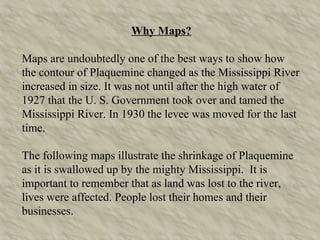
  • 1. Why Maps? Maps are undoubtedly one of the best ways to show how the contour of Plaquemine changed as the Mississippi River increased in size. It was not until after the high water of 1927 that the U. S. Government took over and tamed the Mississippi River. In 1930 the levee was moved for the last time. The following maps illustrate the shrinkage of Plaquemine as it is swallowed up by the mighty Mississippi. It is important to remember that as land was lost to the river, lives were affected. People lost their homes and their businesses.
  • 2. Land Grant Map of 1830 This map of 1830 shows the original land grants for the surrounding area. Antoine Rodriguez, Jean Franchbois, and Joseph Devillier’s grants made up what is now Plaquemine.
  • 3. Map of 1884 Charles H. Dickerson’s map shows Plaquemine’s position relative to the Mississippi River.
  • 4. Aerial Photograph of Previous Map
  • 5. Between the years 1854 and 1930, the Mississippi River devoured over two blocks of Plaquemine. This was due to cave-ins, not to levee breakage. When the river was high, the sandbars located on the east side of the river caused the swift current of the Mississippi River to push against the levee on the Plaquemine side. This pressure washed away the dirt under the levee. When the river fell at the base of the levee, the levee would collapse or cave-in. Because of the large amount of dirt falling into the river, the levee could not be repaired but had to be moved to more solid ground. The next picture shows you one such cave-in. In November of 1897 the cave-in in front of the Roth McWilliams Building on Bank Street was approximately 140 feet deep and 210 feet long.
  • 7. Northeastern Section of Plaquemine, La. in 1854 This is a small section from the official 1854 map of Plaquemine. Note that land from Seminary Street to the river was consumed by the Mississippi River between 1854 and 1930. Seminary St .
  • 8. Map of 1885 These buildings, along with many others, were eventually consumed by the Mississippi River.
  • 9. Map of 1891 Shown are the only buildings on the east side of Bank Street that remained inside the levee. The other buildings located on the east side of Bank Street were lost to the river.
  • 10. Map of 1895 By 1895 all of the buildings located on the east side of Bank Street were lost to the river.
  • 11. Map of 1898 This 1898 map shows the position of the levee after the river continued to swallow up more of Plaquemine. Houses on the west side of Bank Street which were saved by the previous position of the levee are now lost. Dr. Charles Clement’s home on Bank Street was still protected.
  • 12. Buildings Left Behind When the Levee Was Relocated in 1898 (Zenon Labauve, first mayor of Plaquemine, mansion 1838) (The first bank in Plaquemine) (Famous Roth McWilliams Bldg..)
  • 13. Repairing the Levee Near Dr. Charles Clement’s Home
  • 14. The Former Home of Dr. Charles Clement Located on Bank Street At the time of this photograph, the levee was located on the side and front of the house.
  • 15. The New Levee after the Cave-in of the Old Levee (circa 1912) The white house on the right side is the former home of Dr. Charles Clement. Between 1912 and 1916 the levee was moved again, and the place where the house was is now in the river.
  • 16. This map of 1916 shows the levee after having been moved because of a cave-in. The river has consumed most of the property between Bank and Seminary Streets including the home that Dr. Charles Clement built in the late 1830’s.
  • 17. Map of 1930 This map shows the position of the levee after being moved for the last time. The east side of Seminary Street is now at the edge of the levee. Seminary Street
  • 18. Seminary Street (circa 1900) Buildings line both the east and west side of the street.
  • 19. Seminary Street 1998 Levee’s edge forms the east side of Seminary Street.
  • 20. Irishtown, A Suburb of Plaquemine in the 1880’s This area, which was originally located north of the lock, is now in the Mississippi River.
  • 21. Close Up of Irishtown
  • 22. Original Site of Irishtown Original Area Between Seminary And Bank Street
  • 23. Aerial View Looking Toward Mississippi River Original site of Irishtown Originally part of Bank Street
  • 24. Map Showing Fort Constructed by Union Soldiers in 1864 (Located at the End of Fort Street, Now in the River)
  • 25. The Following Three Aerial Photographs of Plaquemine Were Taken Between 1935 and 1940
  • 26.  
  • 27.  
  • 28.