

Recomendados
Mais conteúdo relacionado
Destaque
Destaque (9)
Semelhante a Automatics Unmanned underwater vehicile for mountain lake
Semelhante a Automatics Unmanned underwater vehicile for mountain lake (20)
Último
Último (20)
Automatics Unmanned underwater vehicile for mountain lake
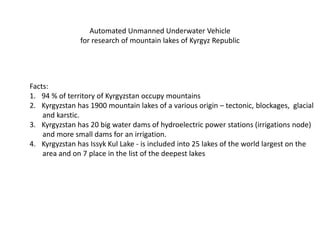
- 1. Automated Unmanned Underwater Vehicle for research of mountain lakes of Kyrgyz Republic Facts: 1. 94 % of territory of Kyrgyzstan occupy mountains 2. Kyrgyzstan has 1900 mountain lakes of a various origin – tectonic, blockages, glacial and karstic. 3. Kyrgyzstan has 20 big water dams of hydroelectric power stations (irrigations node) and more small dams for an irrigation. 4. Kyrgyzstan has Issyk Kul Lake - is included into 25 lakes of the world largest on the area and on 7 place in the list of the deepest lakes
- 2. Issyk Kul Lake The water volume is equal 1738 km ³, the area of a mirror of water — 6236 km ², extent of a coastal line — 688 km, average depth — 278 m, the greatest depth almost in 2,5 times more and equals 702 m. Extent of Issyk Kul from the West on the east is equal 182 km, and from the south on the north — 58 km
- 3. Lake Mertsbaher— mountain Ice- blockages lake, east part of central Tjan-Shan between ridges of Tengri-Tag and Sarydzhaz. Lies in merge of northern and southern branch of a glacier of Inylchek and eats thawing of waters. The lake has been open by expedition under the direction of German geographer Mertsbaher in 1903. It was generated in the termination of a small glacial age (XIX century). Has two pools, 400 m. divided in the height Bottom, the most part of lake from the south is limited by glacial "dam". Annually (twice a year, during the summer and winter period) the bottom part breaks in a river Inylchek valley, completely loses the waters, dumping them within 2-7 days on subglacial channels. Speed of dump can exceed 1000 m ³/s.
- 4. Mounts Lakes
- 5. Toctogul Hydropower station dam The station water basin — takes the second place in Central Asia, has next sizes: the length — 65 km, the mirror area — 284,3 km ², the maximum depth — 120 m. Full capacity of the Toktogulsky water basin makes 19,5 km ³, useful — 14 km ³.
- 6. At imposing of factors of the abundance of water, the raised summer temperatures of deposits and seismic activity break of lakes leading to occurrence mud flow is possible
- 7. Threat of blasting of a dam by terrorists Sample photo from Croatians dams Peruco
- 8. Petrov Lake (Centnera Gold mining company) Control of pollution of technological reservoirs of the mining companies
- 9. Automated Unmanned Underwater Vehicle
- 10. Necessary parameters Constructions - Small weight no more 40kg - Depth of immersing 200m - Delivery in the disassembled condition - An independent power of land station - The replaceable complete set of the equipment - Possibility completely independent work - Distance of leaving from maintenance station(cable variant) 500m - Possibility of independent work from land station - Low temperatures environment - Low atmospheric pressure (high mountains)
- 11. Functions - Possibility of sampling of water and ground - Viewing of objects in the muddy water environment - Definition of ground currents - Installation of control sensor at the bottom dam - Clearing of local places of pollution - Sealing of ground leaking of water - Control of infrasonic seismic waves in water - Ultrasonic definition of density of ground deposits and silt - Capture of biotests - Video supervision
- 12. Power for high mountains UUV Solar batteries Micro hydroelectric power plant Fuel Cell Micro windelectric power plant
- 13. Communications for high mountains UUV VHF telemetry transmitter Satellite modem Radio relay station of tropospheric communication