SlideShare uma empresa Scribd logo
1 de 5
Baixar para ler offline
Rivers of South America
 Name of        Length/ Source/Mouth            Countries in   Major cities along                   Remarks
the River                                          which           the river
                                                  flowing
Amazon          Length: 6800 km                 Brazil         Manaus is the largest •2nd longest river in the world
                                                Peru           city along the R. •Largest river in the world according
                Source:   Mt. Mismi in          Colombia       Amazon (Brazil)       to discharge
                Southern   Peru    (also                                             •Largest drainage basin the world
                known as Nevado Mismi)                                               •Important tributaries are Branco, Rio
                                                                                     Negro, Japura, Apurimac, Madeira,
                Mouth: Atlantic Ocean                                                Pastaza, Napo, Putumayo, Tapajos,
                                                                                     Xingu etc.
                                                                                     •Largest tributary is R. Madeira
Orinoco         Length: 2140 km                 Venezuela      Ciudad Bolivar in • Amazon River Dolphin and Orinoco
                                                Colombia       Venezuela             Piranha can be found in this river.
                Source: W. slopes of the                                             • Orinoco Crocodile is also found in
                Parima Mountains along                                               the river.
                the border between                                                   •There is a natural canal called
                Venezuela and Brazil.                                                Casiquiare Canal which joins the Rio
                                                                                     Negro river, a tributary of Amazon.
                Mouth: Atlantic Ocean                                                •Important tributaries of the river
                                                                                     are Apure, Caroni, Meta, Caura,
                                                                                     Arauca etc.
                                                                                     •Volume wise it is the world’s third
                                                                                     largest river.
Parana          Length: 1090 km                 Brazil         (In Argentina)        • Important tributaries is R. Salado
                                                Paraguay       Rosario, Santa Fe,    •It is the second longest South
                Source: it is formed by the     Argentina      Parana, Resistencia, American River
                union of two rivers,                           Corrientes            • The Itaipu Dam on this river is the
                Paranaiba River & Grande                                             world’s second largest HEP power
                River both occurring in                        (In Brazil)           station in the world.
                Brazil.                                        Sao Paulo,            • For a certain stretch the river forms
                                                               Santos, Araguari      the natural boundary between
                Mouth: Atlantic      Ocean                                           Paraguay & Argentina
                (Rio de la Plata)
Paraguay        Length: 2621 km                 Paraguay       (In Paraguay)          • Important shipping corridor for the
                                                Brazil         Asuncion Concepcion    land locked countries like Bolivia &
                Source:    Mato     Grosso      Argentina      (In Argentina)         Paraguay.
                Region (Brazil)                 Bolivia        Formosa                • There are no dams or HEP projects
                                                                                      located on the rivers.
                Mouth: falls into R. Parana                                           •Fishing is an important economic
                                                                                      activity done in this river.
                                                                                      • The main tributaries are Pilcomayo,
                                                                                      Apa, Negro, Barmejo & Miranda.
Rio de     la   Length: 290 km                  Argentina      Buenos Aires           • It is an estuary where fresh water
Plata                                           Uruguay                               and saline water get mixed
                Source: confluence of                                                 • The La Plata drainage basin is the
                Paraná & Paraguay river                                               continent’s second largest drainage
                                                                                      basin after Amazon
                Mouth:    South     Atlantic                                          • Main tributaries are Uruguay,
                Ocean                                                                 Paraguay and Parana.
                                                                                      •Most of the population of Argentina
                                                                                      & Uruguay are found around this
                                                                                      river.
Magdalena   Length: 1540 km             Colombia         Neiva                     • Main river of Colombia
                                                         Honda                     •Main tributaries are San Jorge, Cesar
            Source: Colombian Massif                     El Dorado                 & Cauca
                                                         Girardot
            Mouth: Atlantic ocean                        Puerto Boyacá
Sao         Length: 2830 km             Brazil           Pirapora                  • Discovered by Amerigo Vespucci
Francisco                                                Bom Jesus da Lapa         • Main tributaries are Grande,
            Source: Canastra Mt.                         Sao Francisco             Paraopeba, Paracatu, Corrente etc
            Range (Brazil)                               Juazeizo                  • Sobradinho reservoir is located on
                                                         Petrolina                 this river which is one of the largest
            Mouth: Atlantic Ocean                                                  artificial lakes in the world.
Tocantins   Length: 2640 km             Brazil                                     • The main tributary is Araguaia. The
                                                                                   other tributaries are Rio das Mortes,
            Source: Pirenues district                                              Paranatinga, Maranhao etc.
            of Brazil                                                              •The famous Tucurui HEP project in
                                                                                   Brazil is located on this river.
            Mouth: Atlantic Ocean


                                                             Rivers of North America

                                                   Name of        Length/                         Remarks
                                                     the       Source/Mouth
                                                    River

                                                 St.          Length: 1197 km       • Forms a part of boundary between
                                                 Lawrence                           USA & Canada
                                                              Source: L. Ontario    • It consists of several lakes, islands
                                                                                    and manmade canals
                                                              Mouth:    Atlantic
                                                                                    • It is the main drainage of the Great
                                                              Ocean (Gulf of St.
                                                                                    Lake Region
                                                              Lawrence)
                                                                                    • It connects the Great Lake region
                                                                                    with Atlantic Ocean
                                                                                    • It falls into the Gulf of St, Lawrence,
                                                                                    which is considered as the world’s
                   Rivers of South America
                                                                                    largest estuary.
                                                                                    • It is the 2nd largest river of Canada
                                                                                    •The main tributaries of the river are
                                                                                    Ottawa, Saguenay, Manicouagan,
                                                                                    Saint-Maurice etc.
                                                                                    • It is an important route of USA-
                                                                                    Canada trade.
                                                                                    • The main cities found along the
                                                                                    river are Quebec City, Montreal,
                                                                                    Cornwall, Brokeville, Cape Vincent
                                                                                    (New York) etc.
Name of the   Length/Source/Mouth                                         Remarks
    River

Mackenzie       Length: 4241 km              • It is the largest and longest river of Canada
                Source: Great Slave Lake     • some important tributaries of the river are Kakisa, Jean Marie,
                in Canada (NW Territories)   Liard, Arctic Red River, Great Bear, Peel, Athabasca, Peace etc
                Mouth:     Arctic   Ocean    • The river is navigable in summer and rest of the year it is used as
                (Beaufort Sea)               frozen roads.
                                             • The main cities found along this river are Fort Simpson, Fort Good
                                             Hope & Inuvik.
                                             • It terms of discharge is ranks second in the continent and fourth in
                                             the world.
Yukon           Length: 3187 km              • The important tributaries of the river are Teslin, Pelly, Takhini,
                Source: Llewellyn Glacier,   Porcupine, Stewart etc.
                British Columbia, Canada     • Fishing is an important activity in this river. It is well know for
                Mouth: Berring Sea           fishing of Salmon.
                                             • It is one of the largest salmon reserves of the world.
                                             • Important towns found along the river are Fort Yukon, Circle,
                                             Dawson, Whitehorse, Carmacks etc.
Churchill       Length: 1609 km              • The main tributary of the river is Beaver River
                Source: Churchill Lake,      • Churchill in Manitoba is the largest city located along the river. It is
                Saskatchewan, Canada         known as the ‘Polar Bear capital of the World’.
                Mouth: Hudson Bay            • Large-scale Fishing is done in this river.
Fraser          Length: 1375 km              • The main tributaries of the river are Pitt, Harrison, Thompson, Stein,
                Source: Canadian Rockies,    Robson, Moose, Nechako, Brunette etc
                British Columbia, Canada     • A 270 km long canyon has been curved by the river, which is known
                Mouth: Strait of Georgia,    as Fraser Canyon.
                Vancouver, Canada            •Moran Canyon Dam project has been proposed on this river.
                                             • The main cities along this river are Chilliwack, Abbotsford & New
                                             Westminster
Columbia             Length: 2000 km                 • Important tributaries of this river are Beaver, Snake, kettle,
                     Source:     Columbia    Lake,   Okanogan, Yakima, and Spillimacheen etc.
                     British Columbia, Canada        • There is a Columbia River Treaty between US & Canada for the
                     Mouth: Pacific Ocean            successful flood control & maximization if HEP generation
                                                     • Some cities located along the river are Northport, Bridgeport,
                                                     Arlington, Roosevelt, Lyle, Columbia City, Prescott etc.
                                                     • The Grand Coulee Dam on this river is the largest electric power
                                                     producing facility in USA. The Dam is a product of Columbia Basin
                                                     Project.
                                                     • Fishing is an important economic activity in this river.
Colorado             Length: 2334 km                 • Some important tributaries of the river are Green River, San Juan
                     Source: Rocky Mountain          River, Paria River, Little Colorado, Virgin River etc.
                     National Park, Colorado, USA    • Hoover Dam, Parker Dam, Davis Dam & Glen Canyon Dam are the
                     Mouth: Gulf of California       two important dam situated across the river.
                                                     • The important cities located along the river are Page, Moab,
                                                     Boulder City, Glenwood Springs, Yuma, Las Vegas, McCoy etc.
                                                     • From its source to the Confluence of Green river it is known as
                                                     Grand River.
                                                     • The city of Moab in the north bank of the river is known for its
                                                     Uranium reserve.
Rio Grande           Length: 3051 km                 • A part of this river forms the natural boundary between US &
                     Source: San Juan Mountain,      Mexico.
                     Colorado, USA                   • The important tributaries are San Juan River, Pecos, Rio Chama, Rio
                     Mouth: Gulf of Mexico           Conchos, Rio Salado etc.
                                                     • The cities located along the river are Nuevo Laredo, El Paso,
                                                     Laredo, Juarez etc
Mississippi          Length: 3734 km                 • Largest river system of the continent.
                     Source: L. Itasca, Minnesota,   • Important tributaries are Arkansas, Red River, Ohio, & Missouri etc.
                     USA                             • Important cities located along the river are Baton Rouge, Memphis,
                     Mouth: Gulf of Mexico           Cape Girardeau, Hannibal, Minneapolis & Rock Island.
  Tributaries of     Missouri                        • It rises from the Centennial Mountains, Montana, USA
 Mississippi River                                   • It is 3767 km long.
                                                     • The important cities located along the river are Bismarck, Omaha,
                                                     Kansas City, St. Louis, Great Fall etc.
                                                     • Longest tributary of Mississippi, (even longer than Mississippi)
                     Ohio                            • Largest tributary of Mississippi.
                                                     • The cities of Pittsburgh, Cincinnati, New Albany, Henderson,
                                                     Petersburg are situated along this river
                                                     • The source of the river is the Allegheny River in Pennsylvania.
                                                     • It is 1579 km long.
                     Arkansas                        • 2nd longest tributary of Mississippi River
                                                     • Rises from the Rocky Mountain, Colorado, USA
                                                     •It is 2350 km long
                                                     • Important cities located along the river are Tulsa, Little Rock, Pine
                                                     Bluff, Pueblo etc.
                     Red river                       • It rises from the state of Oklahoma.
                                                     • It is 2189 km long
                                                     • Elmer, Denison, Texarkana are the main cities located along the
                                                     river.
Rivers of south americaa & north america

Mais conteúdo relacionado

Mais procurados

The amazon rainforest
The amazon rainforestThe amazon rainforest
The amazon rainforestSarmad Khan
 
Discuss Any One Achievement And Failure Of Major Rural Development With Case ...
Discuss Any One Achievement And Failure Of Major Rural Development With Case ...Discuss Any One Achievement And Failure Of Major Rural Development With Case ...
Discuss Any One Achievement And Failure Of Major Rural Development With Case ...RAJKUMARPOREL
 
50427872 narmada-dam-talhah-ppt[1]
50427872 narmada-dam-talhah-ppt[1]50427872 narmada-dam-talhah-ppt[1]
50427872 narmada-dam-talhah-ppt[1]sachindk
 
Physical features of india
Physical features of indiaPhysical features of india
Physical features of indiaArtsUday
 
FLAURA AND FAUNA OF ARUNACHAL PRADESH P.P.T.
FLAURA AND FAUNA OF ARUNACHAL PRADESH P.P.T.FLAURA AND FAUNA OF ARUNACHAL PRADESH P.P.T.
FLAURA AND FAUNA OF ARUNACHAL PRADESH P.P.T.anilyadav611
 
River interlinking
River interlinkingRiver interlinking
River interlinkingVikas Kumar
 
South Asia Physical
South Asia PhysicalSouth Asia Physical
South Asia PhysicalAlison Kurtz
 
Water conflicts in India
Water conflicts in IndiaWater conflicts in India
Water conflicts in IndiaManar Ramadan
 
Zero hunger
Zero hungerZero hunger
Zero hungerJebaKani
 
Poverty around the world
Poverty around the worldPoverty around the world
Poverty around the worldUsama Furqan
 
INDUS WATER TREATY.
INDUS WATER TREATY.INDUS WATER TREATY.
INDUS WATER TREATY.Komal Tiwari
 

Mais procurados (20)

The amazon rainforest
The amazon rainforestThe amazon rainforest
The amazon rainforest
 
Discuss Any One Achievement And Failure Of Major Rural Development With Case ...
Discuss Any One Achievement And Failure Of Major Rural Development With Case ...Discuss Any One Achievement And Failure Of Major Rural Development With Case ...
Discuss Any One Achievement And Failure Of Major Rural Development With Case ...
 
South america
South americaSouth america
South america
 
Narmada bachao andolan
Narmada bachao andolanNarmada bachao andolan
Narmada bachao andolan
 
50427872 narmada-dam-talhah-ppt[1]
50427872 narmada-dam-talhah-ppt[1]50427872 narmada-dam-talhah-ppt[1]
50427872 narmada-dam-talhah-ppt[1]
 
Geography of south asia
Geography of south asiaGeography of south asia
Geography of south asia
 
Poverty in india
Poverty in indiaPoverty in india
Poverty in india
 
Corruption in india
Corruption in indiaCorruption in india
Corruption in india
 
Physical features of india
Physical features of indiaPhysical features of india
Physical features of india
 
FLAURA AND FAUNA OF ARUNACHAL PRADESH P.P.T.
FLAURA AND FAUNA OF ARUNACHAL PRADESH P.P.T.FLAURA AND FAUNA OF ARUNACHAL PRADESH P.P.T.
FLAURA AND FAUNA OF ARUNACHAL PRADESH P.P.T.
 
Andhra Pradesh
Andhra PradeshAndhra Pradesh
Andhra Pradesh
 
River interlinking
River interlinkingRiver interlinking
River interlinking
 
MGNREGA
MGNREGAMGNREGA
MGNREGA
 
South Asia Physical
South Asia PhysicalSouth Asia Physical
South Asia Physical
 
GENDER BUDGETING
GENDER BUDGETINGGENDER BUDGETING
GENDER BUDGETING
 
Water conflicts in India
Water conflicts in IndiaWater conflicts in India
Water conflicts in India
 
India superpower
India superpowerIndia superpower
India superpower
 
Zero hunger
Zero hungerZero hunger
Zero hunger
 
Poverty around the world
Poverty around the worldPoverty around the world
Poverty around the world
 
INDUS WATER TREATY.
INDUS WATER TREATY.INDUS WATER TREATY.
INDUS WATER TREATY.
 

Destaque

Geography of europe1
Geography of europe1Geography of europe1
Geography of europe1Arijit Sarkar
 
Lecture 3 physiography, geography and climate of l.a
Lecture 3  physiography, geography and climate of l.aLecture 3  physiography, geography and climate of l.a
Lecture 3 physiography, geography and climate of l.aArijit Sarkar
 
Phases of the Moon
Phases of the MoonPhases of the Moon
Phases of the Moonkmacdevitt
 
презентацияд. к. ушинский
презентацияд. к. ушинскийпрезентацияд. к. ушинский
презентацияд. к. ушинскийvd23
 
故事與遊戲:好鼻師怎麼變成桌遊
故事與遊戲:好鼻師怎麼變成桌遊故事與遊戲:好鼻師怎麼變成桌遊
故事與遊戲:好鼻師怎麼變成桌遊A-Yue Liu
 
5 basic swedish massage technique
5 basic swedish massage technique5 basic swedish massage technique
5 basic swedish massage techniqueMassage Tutor
 
AWSA GUIDE ON 5 BASIC MASSAGE STROKES (DOH)
AWSA GUIDE ON 5 BASIC MASSAGE STROKES (DOH)AWSA GUIDE ON 5 BASIC MASSAGE STROKES (DOH)
AWSA GUIDE ON 5 BASIC MASSAGE STROKES (DOH)Benjamin Eugenio Jr
 
Africa PowerPoint Map, Africa Map PPT
Africa PowerPoint Map, Africa Map PPTAfrica PowerPoint Map, Africa Map PPT
Africa PowerPoint Map, Africa Map PPTAndy Robs
 
Physical geography of africa i
Physical geography of africa iPhysical geography of africa i
Physical geography of africa iJean L. Moore
 
Africa physical features powerpoint
Africa physical features powerpointAfrica physical features powerpoint
Africa physical features powerpointsonyameverett
 
All about North America
All about North AmericaAll about North America
All about North Americashaikamardayen
 
3.1 North American Geography
3.1 North American Geography3.1 North American Geography
3.1 North American GeographySandy Anthony
 
Geography of North America
Geography of North AmericaGeography of North America
Geography of North AmericaNirmal Roshan
 
Africa’s Landforms
Africa’s LandformsAfrica’s Landforms
Africa’s Landformsmontathomas
 
South America - Intro PPT
South America - Intro PPTSouth America - Intro PPT
South America - Intro PPTMatthew Lawhead
 

Destaque (20)

Davos
DavosDavos
Davos
 
Geography of europe1
Geography of europe1Geography of europe1
Geography of europe1
 
Lecture 3 physiography, geography and climate of l.a
Lecture 3  physiography, geography and climate of l.aLecture 3  physiography, geography and climate of l.a
Lecture 3 physiography, geography and climate of l.a
 
Phases of the Moon
Phases of the MoonPhases of the Moon
Phases of the Moon
 
презентацияд. к. ушинский
презентацияд. к. ушинскийпрезентацияд. к. ушинский
презентацияд. к. ушинский
 
South america project
South america projectSouth america project
South america project
 
North america
North americaNorth america
North america
 
故事與遊戲:好鼻師怎麼變成桌遊
故事與遊戲:好鼻師怎麼變成桌遊故事與遊戲:好鼻師怎麼變成桌遊
故事與遊戲:好鼻師怎麼變成桌遊
 
5 basic swedish massage technique
5 basic swedish massage technique5 basic swedish massage technique
5 basic swedish massage technique
 
AWSA GUIDE ON 5 BASIC MASSAGE STROKES (DOH)
AWSA GUIDE ON 5 BASIC MASSAGE STROKES (DOH)AWSA GUIDE ON 5 BASIC MASSAGE STROKES (DOH)
AWSA GUIDE ON 5 BASIC MASSAGE STROKES (DOH)
 
Africa PowerPoint Map, Africa Map PPT
Africa PowerPoint Map, Africa Map PPTAfrica PowerPoint Map, Africa Map PPT
Africa PowerPoint Map, Africa Map PPT
 
Physical geography of africa i
Physical geography of africa iPhysical geography of africa i
Physical geography of africa i
 
Africa physical features powerpoint
Africa physical features powerpointAfrica physical features powerpoint
Africa physical features powerpoint
 
All about North America
All about North AmericaAll about North America
All about North America
 
3.1 North American Geography
3.1 North American Geography3.1 North American Geography
3.1 North American Geography
 
South america
South  americaSouth  america
South america
 
Geography of North America
Geography of North AmericaGeography of North America
Geography of North America
 
Rivers in Africa
Rivers in AfricaRivers in Africa
Rivers in Africa
 
Africa’s Landforms
Africa’s LandformsAfrica’s Landforms
Africa’s Landforms
 
South America - Intro PPT
South America - Intro PPTSouth America - Intro PPT
South America - Intro PPT
 

Semelhante a Rivers of south americaa & north america

Ferrolterra rivers trabajo ingles final
Ferrolterra rivers trabajo ingles finalFerrolterra rivers trabajo ingles final
Ferrolterra rivers trabajo ingles finalIESCAComenius
 
The Amazon River By Steven Green 97 2003 Powerpoint
The Amazon River By Steven Green  97 2003 PowerpointThe Amazon River By Steven Green  97 2003 Powerpoint
The Amazon River By Steven Green 97 2003 Powerpointyear 6 DBIS
 
South American Geography
South American GeographySouth American Geography
South American GeographyDonald Johnson
 
Amiah presentation amazon media
Amiah presentation amazon mediaAmiah presentation amazon media
Amiah presentation amazon mediaPatty Fesser
 

Semelhante a Rivers of south americaa & north america (8)

Physical Geography Latin America
Physical Geography Latin AmericaPhysical Geography Latin America
Physical Geography Latin America
 
Ferrolterra rivers trabajo ingles final
Ferrolterra rivers trabajo ingles finalFerrolterra rivers trabajo ingles final
Ferrolterra rivers trabajo ingles final
 
Ferrol and surroundings rivers
Ferrol and surroundings rivers Ferrol and surroundings rivers
Ferrol and surroundings rivers
 
The Amazon River By Steven Green 97 2003 Powerpoint
The Amazon River By Steven Green  97 2003 PowerpointThe Amazon River By Steven Green  97 2003 Powerpoint
The Amazon River By Steven Green 97 2003 Powerpoint
 
South American Geography
South American GeographySouth American Geography
South American Geography
 
La physical-features reading2
La physical-features reading2La physical-features reading2
La physical-features reading2
 
Amiah presentation amazon media
Amiah presentation amazon mediaAmiah presentation amazon media
Amiah presentation amazon media
 
Rivers by dyron ellul 3.02
Rivers by dyron ellul 3.02Rivers by dyron ellul 3.02
Rivers by dyron ellul 3.02
 

Mais de Arijit Sarkar

Mais de Arijit Sarkar (16)

Objective current affairs april 2011
Objective current affairs april 2011Objective current affairs april 2011
Objective current affairs april 2011
 
April Current Affairs...
April Current Affairs...April Current Affairs...
April Current Affairs...
 
Wdr 2011 overview 0
Wdr 2011 overview 0Wdr 2011 overview 0
Wdr 2011 overview 0
 
Drainage of india
Drainage of indiaDrainage of india
Drainage of india
 
Drainage of india
Drainage of indiaDrainage of india
Drainage of india
 
North america
North americaNorth america
North america
 
Europe
EuropeEurope
Europe
 
Geography of europe1
Geography of europe1Geography of europe1
Geography of europe1
 
Regionalism and regional arrangements
Regionalism and regional arrangementsRegionalism and regional arrangements
Regionalism and regional arrangements
 
Permutation and combination
Permutation and combinationPermutation and combination
Permutation and combination
 
Maoist insurgency
Maoist insurgencyMaoist insurgency
Maoist insurgency
 
Ibsa
IbsaIbsa
Ibsa
 
Global terrorism
Global terrorismGlobal terrorism
Global terrorism
 
Organizations
OrganizationsOrganizations
Organizations
 
Disarmament
DisarmamentDisarmament
Disarmament
 
Geography of europe1
Geography of europe1Geography of europe1
Geography of europe1
 

Rivers of south americaa & north america

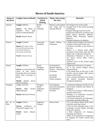
  • 1. Rivers of South America Name of Length/ Source/Mouth Countries in Major cities along Remarks the River which the river flowing Amazon Length: 6800 km Brazil Manaus is the largest •2nd longest river in the world Peru city along the R. •Largest river in the world according Source: Mt. Mismi in Colombia Amazon (Brazil) to discharge Southern Peru (also •Largest drainage basin the world known as Nevado Mismi) •Important tributaries are Branco, Rio Negro, Japura, Apurimac, Madeira, Mouth: Atlantic Ocean Pastaza, Napo, Putumayo, Tapajos, Xingu etc. •Largest tributary is R. Madeira Orinoco Length: 2140 km Venezuela Ciudad Bolivar in • Amazon River Dolphin and Orinoco Colombia Venezuela Piranha can be found in this river. Source: W. slopes of the • Orinoco Crocodile is also found in Parima Mountains along the river. the border between •There is a natural canal called Venezuela and Brazil. Casiquiare Canal which joins the Rio Negro river, a tributary of Amazon. Mouth: Atlantic Ocean •Important tributaries of the river are Apure, Caroni, Meta, Caura, Arauca etc. •Volume wise it is the world’s third largest river. Parana Length: 1090 km Brazil (In Argentina) • Important tributaries is R. Salado Paraguay Rosario, Santa Fe, •It is the second longest South Source: it is formed by the Argentina Parana, Resistencia, American River union of two rivers, Corrientes • The Itaipu Dam on this river is the Paranaiba River & Grande world’s second largest HEP power River both occurring in (In Brazil) station in the world. Brazil. Sao Paulo, • For a certain stretch the river forms Santos, Araguari the natural boundary between Mouth: Atlantic Ocean Paraguay & Argentina (Rio de la Plata) Paraguay Length: 2621 km Paraguay (In Paraguay) • Important shipping corridor for the Brazil Asuncion Concepcion land locked countries like Bolivia & Source: Mato Grosso Argentina (In Argentina) Paraguay. Region (Brazil) Bolivia Formosa • There are no dams or HEP projects located on the rivers. Mouth: falls into R. Parana •Fishing is an important economic activity done in this river. • The main tributaries are Pilcomayo, Apa, Negro, Barmejo & Miranda. Rio de la Length: 290 km Argentina Buenos Aires • It is an estuary where fresh water Plata Uruguay and saline water get mixed Source: confluence of • The La Plata drainage basin is the Paraná & Paraguay river continent’s second largest drainage basin after Amazon Mouth: South Atlantic • Main tributaries are Uruguay, Ocean Paraguay and Parana. •Most of the population of Argentina & Uruguay are found around this river.
  • 2. Magdalena Length: 1540 km Colombia Neiva • Main river of Colombia Honda •Main tributaries are San Jorge, Cesar Source: Colombian Massif El Dorado & Cauca Girardot Mouth: Atlantic ocean Puerto Boyacá Sao Length: 2830 km Brazil Pirapora • Discovered by Amerigo Vespucci Francisco Bom Jesus da Lapa • Main tributaries are Grande, Source: Canastra Mt. Sao Francisco Paraopeba, Paracatu, Corrente etc Range (Brazil) Juazeizo • Sobradinho reservoir is located on Petrolina this river which is one of the largest Mouth: Atlantic Ocean artificial lakes in the world. Tocantins Length: 2640 km Brazil • The main tributary is Araguaia. The other tributaries are Rio das Mortes, Source: Pirenues district Paranatinga, Maranhao etc. of Brazil •The famous Tucurui HEP project in Brazil is located on this river. Mouth: Atlantic Ocean Rivers of North America Name of Length/ Remarks the Source/Mouth River St. Length: 1197 km • Forms a part of boundary between Lawrence USA & Canada Source: L. Ontario • It consists of several lakes, islands and manmade canals Mouth: Atlantic • It is the main drainage of the Great Ocean (Gulf of St. Lake Region Lawrence) • It connects the Great Lake region with Atlantic Ocean • It falls into the Gulf of St, Lawrence, which is considered as the world’s Rivers of South America largest estuary. • It is the 2nd largest river of Canada •The main tributaries of the river are Ottawa, Saguenay, Manicouagan, Saint-Maurice etc. • It is an important route of USA- Canada trade. • The main cities found along the river are Quebec City, Montreal, Cornwall, Brokeville, Cape Vincent (New York) etc.
  • 3. Name of the Length/Source/Mouth Remarks River Mackenzie Length: 4241 km • It is the largest and longest river of Canada Source: Great Slave Lake • some important tributaries of the river are Kakisa, Jean Marie, in Canada (NW Territories) Liard, Arctic Red River, Great Bear, Peel, Athabasca, Peace etc Mouth: Arctic Ocean • The river is navigable in summer and rest of the year it is used as (Beaufort Sea) frozen roads. • The main cities found along this river are Fort Simpson, Fort Good Hope & Inuvik. • It terms of discharge is ranks second in the continent and fourth in the world. Yukon Length: 3187 km • The important tributaries of the river are Teslin, Pelly, Takhini, Source: Llewellyn Glacier, Porcupine, Stewart etc. British Columbia, Canada • Fishing is an important activity in this river. It is well know for Mouth: Berring Sea fishing of Salmon. • It is one of the largest salmon reserves of the world. • Important towns found along the river are Fort Yukon, Circle, Dawson, Whitehorse, Carmacks etc. Churchill Length: 1609 km • The main tributary of the river is Beaver River Source: Churchill Lake, • Churchill in Manitoba is the largest city located along the river. It is Saskatchewan, Canada known as the ‘Polar Bear capital of the World’. Mouth: Hudson Bay • Large-scale Fishing is done in this river. Fraser Length: 1375 km • The main tributaries of the river are Pitt, Harrison, Thompson, Stein, Source: Canadian Rockies, Robson, Moose, Nechako, Brunette etc British Columbia, Canada • A 270 km long canyon has been curved by the river, which is known Mouth: Strait of Georgia, as Fraser Canyon. Vancouver, Canada •Moran Canyon Dam project has been proposed on this river. • The main cities along this river are Chilliwack, Abbotsford & New Westminster
  • 4. Columbia Length: 2000 km • Important tributaries of this river are Beaver, Snake, kettle, Source: Columbia Lake, Okanogan, Yakima, and Spillimacheen etc. British Columbia, Canada • There is a Columbia River Treaty between US & Canada for the Mouth: Pacific Ocean successful flood control & maximization if HEP generation • Some cities located along the river are Northport, Bridgeport, Arlington, Roosevelt, Lyle, Columbia City, Prescott etc. • The Grand Coulee Dam on this river is the largest electric power producing facility in USA. The Dam is a product of Columbia Basin Project. • Fishing is an important economic activity in this river. Colorado Length: 2334 km • Some important tributaries of the river are Green River, San Juan Source: Rocky Mountain River, Paria River, Little Colorado, Virgin River etc. National Park, Colorado, USA • Hoover Dam, Parker Dam, Davis Dam & Glen Canyon Dam are the Mouth: Gulf of California two important dam situated across the river. • The important cities located along the river are Page, Moab, Boulder City, Glenwood Springs, Yuma, Las Vegas, McCoy etc. • From its source to the Confluence of Green river it is known as Grand River. • The city of Moab in the north bank of the river is known for its Uranium reserve. Rio Grande Length: 3051 km • A part of this river forms the natural boundary between US & Source: San Juan Mountain, Mexico. Colorado, USA • The important tributaries are San Juan River, Pecos, Rio Chama, Rio Mouth: Gulf of Mexico Conchos, Rio Salado etc. • The cities located along the river are Nuevo Laredo, El Paso, Laredo, Juarez etc Mississippi Length: 3734 km • Largest river system of the continent. Source: L. Itasca, Minnesota, • Important tributaries are Arkansas, Red River, Ohio, & Missouri etc. USA • Important cities located along the river are Baton Rouge, Memphis, Mouth: Gulf of Mexico Cape Girardeau, Hannibal, Minneapolis & Rock Island. Tributaries of Missouri • It rises from the Centennial Mountains, Montana, USA Mississippi River • It is 3767 km long. • The important cities located along the river are Bismarck, Omaha, Kansas City, St. Louis, Great Fall etc. • Longest tributary of Mississippi, (even longer than Mississippi) Ohio • Largest tributary of Mississippi. • The cities of Pittsburgh, Cincinnati, New Albany, Henderson, Petersburg are situated along this river • The source of the river is the Allegheny River in Pennsylvania. • It is 1579 km long. Arkansas • 2nd longest tributary of Mississippi River • Rises from the Rocky Mountain, Colorado, USA •It is 2350 km long • Important cities located along the river are Tulsa, Little Rock, Pine Bluff, Pueblo etc. Red river • It rises from the state of Oklahoma. • It is 2189 km long • Elmer, Denison, Texarkana are the main cities located along the river.