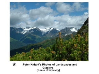
2. The smallest scale of glaciation: Niche glaciers and ice aprons in the Grand Tetons, Wyoming, USA. Small glaciers such as these are often the most sensitive to local climate change. Niche glaciers
3. The summit ice cap of the volcano, Cotopaxi, Ecuador The ice cap extends further on one side of the mountain. The side of the mountain facing the moisture-bearing winds has higher snowfall and hence more extensive glaciation. The deep channels carved by meltwater and by volcanic mudflows (lahars) caused by melting of snow and ice during eruptions.
22. Match the following features to the numbers on the diagram. Arête; Hanging Valley; Corrie (or Cirque); 'U' Shaped Valley; Alluvial Fan; Pyramidal Peak; Corrie Lochan (or Tarn); Misfit Stream; Ribbon Lake; Truncated Spur; Screes.
23. 1 is a Pyramidal Peak because it has steep, triangular faces divided by sharp ridges or arêtes. 2 is an Arête , because it is a sharp ridge between corries. 3 is a Corrie or Cirque , because it is an armchair shaped hollow with steep back and sides. 4 is a Corrie Lochan or Tarn , because water has gathered in the hollow in the floor of the corrie. 5 is an Alluvial Fan , because it is a fan shaped pile of rock remains (alluvium) washed down by the stream and piled up where the steep valley side meets the valley floor. 6 is a Ribbon Lake , because it is a long narrow lake in a part of the valley cut deeper by the glacier. 7 is a Truncated Spur , because the ridge has been cut off sharply by the ice that flowed down the main valley. 8 is a Misfit Stream , because it is far too small to have cut the valley. 9 is a Hanging Valley , because the valley floor is much higher than the floor of the main valley. 10 is a 'U' Shaped Valley , because it has steep sides and a nearly flat floor. (The other side of the valley is missing in this cut-away
25. 1 is a Terminal Moraine. A hummocky ridge of unsorted stones, boulders and clays dumped by the glacier at the furthest point it reached 2 is a Drumlin. A long, rounded mound of till, moulded under the flowing ice. Its narrower end points in the direction that the ice was moving. They usually occur in groups (swarms). 3 is a Kettle. A water filled hollow left when a block of ice in the till or outwash melted to leave a hollow. 4 is an Esker. A long, winding ridge of sands and gravels left by a stream which ran in an ice tunnel under the melting glacier. 5 is Till (Ground Moraine or Boulder Clay). A mixture of broken rocks and clay plastered over the bedrock under the base of the glacier. 6 is an Outwash Plain. A nearly flat expanse of sorted sands and gravels washed out of the glacier and carried beyond the terminal moraine. 7 is Sorted sands and gravels. The meltwaters washed these away from the glacier, rounding off angular stones and depositing them in layers. Largest first, smallest last (sorting).