Station area plan jan 2013
•Transferir como PPT, PDF•
0 gostou•425 visualizações

The document provides guidelines for creating Station Area Plans (SAPs) to promote smart growth near transit stations. A SAP focuses development within a half mile of a transit station. They integrate land use and transit and create compact, walkable neighborhoods. SAPs are needed due to changing demographics, population growth, and limits on road capacity. The Sierra Club created guidelines to educate on building livable communities by focusing on compact development, community benefits, pedestrian access, transportation options, and green buildings. The guidelines include a scoring system to evaluate SAP proposals.

Recomendados
Recomendados
Mais conteúdo relacionado
Semelhante a Station area plan jan 2013
Semelhante a Station area plan jan 2013 (20)
Mais de Adina Levin
Mais de Adina Levin (20)
Station area plan jan 2013
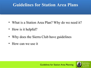
- 1. Guidelines for Station Area Plans Guidelines for Station Area Plans • What is a Station Area Plan? Why do we need it? • How is it helpful? • Why does the Sierra Club have guidelines • How can we use it Guidelines for Station Area Planning
- 2. Guidelines for Station Area Plans Guidelines for Station Area Plans What is a SAP What is a Station Area Plan? Smart growth: • Integrate land use and transit Guidelines for Station Area Planning
- 3. Guidelines for Station Area Plans Guidelines for Station Area Plans What is a SAP What is a Station Area Plan? Smart growth: • Integrate land use and transit • Compact, walkable, mixed-use neighborhood • 1/2 mile radius of a transit station. Guidelines for Station Area Planning
- 4. Guidelines for Station Area Plans Guidelines for Station Area Plans Why do we need it Changing demographics + Growth of our population Guidelines for Station Area Planning
- 5. Guidelines for Station Area Plans Guidelines for Station Area Plans Why do we need it Senior Tsunami • in less than 20 years, 1/4 of the adult population of our county will be over 65. • Many will be non- drivers Guidelines for Station Area Planning
- 6. Guidelines for Station Area Plans Guidelines for Station Area Plans Why do we need it Young people: singles, couples without children, Guidelines for Station Area Planning
- 7. Guidelines for Station Area Plans Guidelines for Station Area Plans Why do we need it More people are electing to remain single as a lifestyle Guidelines for Station Area Planning
- 8. Guidelines for Station Area Plans Guidelines for Station Area Plans And our workforce needs to live near jobs Guidelines for Station Area Planning
- 9. Guidelines for Station Area Plans Guidelines for Station Area Plans Why do we need it Changing demographics + Growth of our population Freeways are at capacity + Need healthier lifestyles Guidelines for Station Area Planning
- 10. Guidelines for Station Area Plans Guidelines for Station Area Plans How it is helpful to do an SAP? State Law requires towns to meet SB 375 and AB 32 • climate change • green house gas emissions Bay Area Air Quality Management District (BAAQMD! • new clean air standards So…… Association of Bay Area Governments: • Reduce auto use • Modify land-use to support TRANSIT •JOBS- HOUSING balance is goal Guidelines for Station Area Planning
- 11. Guidelines for Station Area Plans Guidelines for Station Area Plans Menlo Park Station Area Plan • >1% of Menlo Park • Create housing for new demographic • Create vibrant economic town center • Support transit with compact development and mix of uses Guidelines for Station Area Planning
- 12. Guidelines for Station Area Plans Guidelines for Station Area Plans Why does Sierra Club have Guidelines? Guidelines for Station Area Planning
- 13. Guidelines for Station Area Plans Guidelines for Station Area Plans Why does Sierra Club have Guidelines? • Guidelines for Station Area Plans (SAP) for cities • Guidelines for Transit Oriented Development (TOD) for developers Guidelines for Station Area Planning
- 14. Guidelines for Station Area Plans Guidelines for Station Area Plans WHAT ARE THESE GUIDELINES? Focus on FIVE issues • Compact growth • Community benefits • Pedestrian top priority • Transportation options: walk bike, shuttles, buses, transit passes, car share, bike share, TDM, etc. • Green buildings and site Guidelines for Station Area Planning
- 15. Guidelines for Station Area Plans Guidelines for Station Area Plans How can we use it? • Educate City officials • Educate the client • Educate the public • Meet state law • While preserving neighborhooods Guidelines for Station Area Planning
- 16. 1. Urban Form 1. Urban Form A. Compact Development A. Compact Development Use highest score Guidelines for Station Area Planning
- 17. 1. Urban Form 1. Urban Form B. Affordability B. Affordability Use highest score Guidelines for Station Area Planning
- 18. 2. Community & Economic Benefits- 2. Community & Economic Benefits- A. Household Trips Accommodated A. Household Trips Accommodated 1 2 3 4 5 76-80 81-85 86-90 91-95 96-100 pts. pts. pts. pts. pts. www.walkscore.com Use highest score Guidelines for Station Area Planning
- 19. 2. Community & Economic Benefits- 2. Community & Economic Benefits- B. Additional Community & Economic Benefits – 1 point each B. Additional Community & Economic Benefits – 1 point each ….to create a vibrant neighborhood • “A Sense of Place” • Prioritize existing local businesses • State-of-the-Art Telecommunications facilities • Safe Routes to Schools • Upgraded parks • Access to Open Space • Daycare facilities • Bike facilities & Complete Streets • Electric Car charging spots • Car Share within 3 blocks 10 possible points Guidelines for Station Area Planning
- 20. 2. Additional Community & Economic Benefits 2. Additional Community & Economic Benefits EXAMPLE: Fruitvale Transit Village at BART, Oakland EXAMPLE: Fruitvale Transit Village at BART, Oakland Features: • Public Plaza • Farmers Market • Retail & Restaurants • Office Space How many points would it get? Guidelines for Station Area Planning
- 21. 2. Additional Community & Economic Benefits 2. Additional Community & Economic Benefits EXAMPLE: Fruitvale Transit Village at BART, Oakland EXAMPLE: Fruitvale Transit Village at BART, Oakland Features: • Public Plaza • Farmers Market • Retail & Restaurants • Office Space • Library • Child Care Facility • Health Clinic • <20% national chains • Local Festivals How many points would it get? Guidelines for Station Area Planning
- 22. 3. Pedestrian Priority 3. Pedestrian Priority EXAMPLE: CASTRO STREET, MOUNTAIN VIEW EXAMPLE: CASTRO STREET, MOUNTAIN VIEW • Auto traffic is slowed • Wide active sidewalk • Train station nearby • On bus route • SENSE of PLACE • Elegant street details • No chain stores • Mid block crossings • Mid block “Paseos” Guidelines for Station Area Planning
- 23. 3. Pedestrian Priority EXAMPLE: CASTRO STREET, MOUNTAIN VIEW • Auto traffic is slowed • Wide active sidewalk • Train station near • On bus route • SENSE of PLACE • Elegant street details • No chain stores • Mid block crossings • Mid block “Paseos” Guidelines for Station Area Planning
- 24. 4. Transportation Alternatives 1 point each 1 1 1 1 1 Each street Auto L.O.S. Equal modal Congestion Streets used priority rated not used splits priority pricing for for uses e.g. parking plaza Guidelines for Station Area Planning
- 25. 4. More Transportation Alternatives 1 point each 1 1 1 1 1 Free transit Bike Share Free Access to Bicycle pass within Shuttle buses bike and ped boulevards provided 3 blocks trails Guidelines for Station Area Planning
- 26. 5. Energy & Resource Efficiency 5. Energy & Resource Efficiency Green Building – Use highest Score Green Building – Use highest Score Guidelines for Station Area Planning
- 27. 5. Additional Energy Efficiency features 5. Additional Energy Efficiency features One Point each One Point each 1 1 1 1 1 Low Impact Restored FSC certified De- Other Develop- natural or recycled constructed innovations ment services wood used at up to 75% (e.g.greywater) (e.g.creeks) 75% Guidelines for Station Area Planning
- 28. 5. Energy & Resource Efficient 5. Energy & Resource Efficient Example: California Academy of Sciences, San Francisco Example: California Academy of Sciences, San Francisco Reducing the carbon footprint and Preserving the natural world. Guidelines for Station Area Planning
- 29. Guidelines Scorecard Guidelines Scorecard The process used to review projects & make recommendations The process used to review projects & make recommendations Maximum possible score: 75 1. Compact Urban Form & Affordability 10 2. Community & Economic Benefits 30 3. Pedestrian Priority 5 4. Transportation Alternatives 15 5. Energy & Resource Efficiency 10 6. Other Features not listed 5 Min. Passing Grade is 30-35 however Goal 50 is: Guidelines for Station Area Planning
- 30. Guidelines created by: Guidelines created by: Sustainable Land Use Committee Sierra Club Loma Prieta Chapter The Guidelines and Scorecard are tools for A vibrant livable “Station Area Plan” Guidelines for Station Area Planning
Notas do Editor
- On October 7, 2008, the U.S. Green Building Council awarded the Academy a Platinum-level LEED certification.
- Kind of a lot of text for a slide... any thoughts? This is just a first attempt at "The Goal"