SlideShare uma empresa Scribd logo
1 de 65
DISTRICT PLAN
                                   (Rashtriya Sam Vikas Yojana)
                                    Backward District Initiatives
       OBJECTIVE
Ø PREPARATION OF THREE
  YEARS MASTER PLAN


           BASIS
SWOT          * Strength           Ø Preparation of Location Map
ANALYSIS      * Weaknesses
              * Opportunities      Ø Natural Resources Mapping
              * Threat
                                   Ø Human Resources Mapping

         STEPS                     Ø Infrastructure and Amenities Mapping
                                   Ø Database of Special Economic Activities
    Resource Inventory               Strengths, Weaknesses, Opportunities,
                                     Threats and identification of critical gaps

   Strength of the District        Ø Association Map of Resources,
                                     Infrastructure, Gaps, Priorities and Models
Identification of Critical Areas


Schemes to fill up these Gaps
1.   Preparation of Location Map
2.   Data and Mapping of population, density, socio-economic indicators
                                              socio-
3.   Natural Resources Mapping
     i)     Landuse/Land
            Landuse/Land Cover
     ii)    Forest
     iii)   Drainage (Rivers and Streams)
     iv)    Water Resources (Reservoirs, Lakes, Tanks, etc.)
                                                       etc.
     v)     Soil
     vi)    Slope
     vii) Geomorphology/ hyderogeomorphology
          Geomorphology/hyderogeomorphology
     viii) Geology
4. Human Resources Mapping
    i)     Population Distribution
•   ii)    Literacy
•   iii)   Educational Levels
•   iv) Technical Education/ Skilled Manpower Reserves
•   v)     Population in the working age group
•   vi)    Unemployment/Underemployment
•   vii) Poverty (BPL)
5. Infrastructure and Amenities Mapping
    i)     Roads/Connectivity
    ii)    Railways
    iii)   Telecommunication
    iv)    Irrigation
    v)     Agricultural Implements
    vi)    Credit Facilities
    vii)   Seeds/HYV/Fertilizer/Pesticide Distribution or Sale Centre/Shop
    viii) Hospitals and Health Centres
    ix)    Other Health Facilities
    x)     Schools and Educational Centres
    xi)    Vocational/Training Institute (Polytechnic/ITI)
    xii)   Research Institute
    xiii) Housing
    xiv) Electricity
    xv) Access to Safe Drinking Water Facility
    xvi) Toilet
    xvii) Environmental Health
6. Database of NGOs and Self Help Groups
7. Database of Special Economic Activities of the District
8. Strengths, Weaknesses, Opportunities, Threats & identification of critical gaps
•   i)     Strengths and Weaknesses
•   ii)    Areas of Special Attention
•   iii)   Identification and Distribution of Target Areas/Groups or Communities
•   iv)    Identification of Lead Sectors/ Sick Sectors
•   v)     Critical Gaps
9. Association Map of Resources, Infrastructure, Gaps,
                      Priorities and Models
i)    Land and Water Management (Check Dams, Revitalization of Traditional
      Water Structures, Small Lift Irrigation Projects, Mini-Diversion Weirs, etc.
                                                        Mini-                 etc.
ii)   Health Infrastructure (Location of PHC, Sub-Centres, ANM, Anganwadi
                                              Sub-Centres,
      Centres strengthen Health Care System for proper Preventive, Promotive
      and Curative Health Care, Institutional Deliveries and Medical Assistance
      at Birth.
         Birth.
iii) Educational Infrastructure at proper location
iv) Vocational Training Centres (Projection and Location for Job Market and
    Self Employment)
v) Increase in Income by agriculture and allied activities through the
   identification of agriculture and horticulture practices, dry land farming,
   improving yields from dairying, animal husbandry, pisciculture, etc,
                                                             pisciculture,
   veterinary and credit and market facilities (Suggestion for suitable lands,
   areas, etc.)
          etc.
vi) Filling critical gaps in above areas
Village Information System (VIS)
“The Village Information System (VIS) is an
integrated system of Spatial and Non Spatial
Database and Customized GIS Softwares to generate
and integrate comprehensive information on all
aspects of development at Village, Panchayat, Block,
District and State Level administrative units using
Space Technology to help formulate a proper
development strategy in order to meet the service
gaps and strengthen overall rural development.”
VIEW OF NAMKUM BLOCK FROM SATELLITE
NAMKUM BLOCK
                                                     M
                                             GEOMORP
                                                   PHOLOGY
                                                                200
                                                                  04
                                                                         c   k
                                                                   . B lo
                                                              e C.D
                                                         Kank


                                                                                               Ang
                                                                                                                                   N


                                                                                                  ara
                                                                                                                              W        E


                                                                                                   C.
                                                                                                      D.
                                                                                                         Bl
                                                                                                           ck                      S


                                                                                                            o
                              ck
                           Blo
                        D.
                      C.
                    n ia
                  Ra
             ck
        Bl o
    . D.
   C
  rra
Ka


                                                                                                        Index
                                                                                                                DENUDATIONAL HILL
                                                                                                                HIL L TOP WEATHERED


                                                                                                 ck
                                                                                              lo
                                                                                                                INSELBERG


                                                                                             .B
                                                                                           .D
                                                                                                                INTERMONTANE VALLEY


                                                                                          C
                                                                                        u
                                                                                                                LATERITIC PLAIN MODERATE


                                                                                      nd
                                                                                     Bu
                                                                                                                PEDIMENT INSELBERG COMPLEX
                                                                                                                PL ATEAU MODERATELY DISSECTED
                                                                                                                PL ATEAU WEATHERED MODERATE
                                                                                                                PL ATEAU WEATHERED SHALLOW
                                                                                                                RESERVOIR
                                   K hunti C.D. Bloc k
                                                                                                                RESIDUAL HILL
                                                                                                                RIVER
                                                                                                                STRUCTURAL HILL
                                                                  Kilo
                                                                     ometers                                    VALLEY
                                         5                             0         5                              VALLEY FILL SHALLOW
                                                                                                                VALLEY GULLY
Iirs district plan1
Iirs district plan1
Iirs district plan1
Iirs district plan1
Iirs district plan1
Iirs district plan1
Iirs district plan1
Iirs district plan1
Iirs district plan1
Iirs district plan1
Iirs district plan1
Iirs district plan1
Iirs district plan1
Iirs district plan1
Iirs district plan1
Iirs district plan1
Iirs district plan1
Iirs district plan1
Iirs district plan1
Iirs district plan1
Iirs district plan1
Iirs district plan1
Iirs district plan1
Iirs district plan1
Iirs district plan1
Iirs district plan1
Iirs district plan1
Iirs district plan1
Iirs district plan1
Iirs district plan1
Iirs district plan1
Iirs district plan1
Iirs district plan1
Iirs district plan1
Iirs district plan1
Iirs district plan1
Iirs district plan1
Iirs district plan1
Iirs district plan1
Iirs district plan1
Iirs district plan1
Iirs district plan1
Iirs district plan1
Iirs district plan1
Iirs district plan1
Iirs district plan1
Iirs district plan1
Iirs district plan1
Iirs district plan1
Iirs district plan1
Iirs district plan1
Iirs district plan1
Iirs district plan1
Iirs district plan1

Mais conteúdo relacionado

Mais de Tushar Dholakia

Iirs Institutions-Geospatial services in India
Iirs Institutions-Geospatial services in IndiaIirs Institutions-Geospatial services in India
Iirs Institutions-Geospatial services in IndiaTushar Dholakia
 
Iirs Artificial Naural network based Urban growth Modeling
Iirs Artificial Naural network based Urban growth ModelingIirs Artificial Naural network based Urban growth Modeling
Iirs Artificial Naural network based Urban growth ModelingTushar Dholakia
 
Iirs remote sensing data policy (RSDP)
Iirs remote sensing data policy (RSDP)Iirs remote sensing data policy (RSDP)
Iirs remote sensing data policy (RSDP)Tushar Dholakia
 
Iirs Role of Remote sensing and GIS in Ground water studies
Iirs Role of Remote sensing and GIS in Ground water studiesIirs Role of Remote sensing and GIS in Ground water studies
Iirs Role of Remote sensing and GIS in Ground water studiesTushar Dholakia
 
Iirs Remote sensing and GIS application in Agricultur- Indian Experience
Iirs Remote sensing and GIS application in Agricultur- Indian ExperienceIirs Remote sensing and GIS application in Agricultur- Indian Experience
Iirs Remote sensing and GIS application in Agricultur- Indian ExperienceTushar Dholakia
 
Iirs Remote sensing application in Urban Planning
Iirs Remote sensing application in Urban PlanningIirs Remote sensing application in Urban Planning
Iirs Remote sensing application in Urban PlanningTushar Dholakia
 
Iirs- Opensources software solutions and Data services for Domain
Iirs- Opensources software solutions and Data services for DomainIirs- Opensources software solutions and Data services for Domain
Iirs- Opensources software solutions and Data services for DomainTushar Dholakia
 
effective use of consultant
effective use of consultanteffective use of consultant
effective use of consultantTushar Dholakia
 
LARGE SCALE INSTALLATION OF SUBSURFACE DRAINAGE SYSTEM
LARGE SCALE INSTALLATION OF SUBSURFACE DRAINAGE SYSTEM LARGE SCALE INSTALLATION OF SUBSURFACE DRAINAGE SYSTEM
LARGE SCALE INSTALLATION OF SUBSURFACE DRAINAGE SYSTEM Tushar Dholakia
 
Panam Project Presentation
Panam Project PresentationPanam Project Presentation
Panam Project PresentationTushar Dholakia
 
Design Aspects of Gates of Dam
Design Aspects of Gates of DamDesign Aspects of Gates of Dam
Design Aspects of Gates of DamTushar Dholakia
 
Scope and prospects of micro irrigation
Scope and prospects of micro irrigationScope and prospects of micro irrigation
Scope and prospects of micro irrigationTushar Dholakia
 
Rule level & gate operation
Rule level & gate operationRule level & gate operation
Rule level & gate operationTushar Dholakia
 
Agriculture of Gujarat State- Green Revolution
Agriculture of Gujarat State- Green RevolutionAgriculture of Gujarat State- Green Revolution
Agriculture of Gujarat State- Green RevolutionTushar Dholakia
 
Micro Irrigation in Gujarat
Micro Irrigation in Gujarat Micro Irrigation in Gujarat
Micro Irrigation in Gujarat Tushar Dholakia
 
Dam safety & Safety Devices
Dam safety & Safety DevicesDam safety & Safety Devices
Dam safety & Safety DevicesTushar Dholakia
 

Mais de Tushar Dholakia (20)

Iirs Institutions-Geospatial services in India
Iirs Institutions-Geospatial services in IndiaIirs Institutions-Geospatial services in India
Iirs Institutions-Geospatial services in India
 
Iirs Artificial Naural network based Urban growth Modeling
Iirs Artificial Naural network based Urban growth ModelingIirs Artificial Naural network based Urban growth Modeling
Iirs Artificial Naural network based Urban growth Modeling
 
Iirs remote sensing data policy (RSDP)
Iirs remote sensing data policy (RSDP)Iirs remote sensing data policy (RSDP)
Iirs remote sensing data policy (RSDP)
 
Iirs Role of Remote sensing and GIS in Ground water studies
Iirs Role of Remote sensing and GIS in Ground water studiesIirs Role of Remote sensing and GIS in Ground water studies
Iirs Role of Remote sensing and GIS in Ground water studies
 
Iirs gps dmc 2010
Iirs gps dmc 2010Iirs gps dmc 2010
Iirs gps dmc 2010
 
Iirs - Overview of GIS
Iirs - Overview of GISIirs - Overview of GIS
Iirs - Overview of GIS
 
Iirs Remote sensing and GIS application in Agricultur- Indian Experience
Iirs Remote sensing and GIS application in Agricultur- Indian ExperienceIirs Remote sensing and GIS application in Agricultur- Indian Experience
Iirs Remote sensing and GIS application in Agricultur- Indian Experience
 
Iirs Remote sensing application in Urban Planning
Iirs Remote sensing application in Urban PlanningIirs Remote sensing application in Urban Planning
Iirs Remote sensing application in Urban Planning
 
Iirs- Opensources software solutions and Data services for Domain
Iirs- Opensources software solutions and Data services for DomainIirs- Opensources software solutions and Data services for Domain
Iirs- Opensources software solutions and Data services for Domain
 
effective use of consultant
effective use of consultanteffective use of consultant
effective use of consultant
 
Nashik photos
Nashik photosNashik photos
Nashik photos
 
LARGE SCALE INSTALLATION OF SUBSURFACE DRAINAGE SYSTEM
LARGE SCALE INSTALLATION OF SUBSURFACE DRAINAGE SYSTEM LARGE SCALE INSTALLATION OF SUBSURFACE DRAINAGE SYSTEM
LARGE SCALE INSTALLATION OF SUBSURFACE DRAINAGE SYSTEM
 
Panam Project Presentation
Panam Project PresentationPanam Project Presentation
Panam Project Presentation
 
Design Aspects of Gates of Dam
Design Aspects of Gates of DamDesign Aspects of Gates of Dam
Design Aspects of Gates of Dam
 
Scope and prospects of micro irrigation
Scope and prospects of micro irrigationScope and prospects of micro irrigation
Scope and prospects of micro irrigation
 
Rule level & gate operation
Rule level & gate operationRule level & gate operation
Rule level & gate operation
 
Irrigation Efficiency
Irrigation EfficiencyIrrigation Efficiency
Irrigation Efficiency
 
Agriculture of Gujarat State- Green Revolution
Agriculture of Gujarat State- Green RevolutionAgriculture of Gujarat State- Green Revolution
Agriculture of Gujarat State- Green Revolution
 
Micro Irrigation in Gujarat
Micro Irrigation in Gujarat Micro Irrigation in Gujarat
Micro Irrigation in Gujarat
 
Dam safety & Safety Devices
Dam safety & Safety DevicesDam safety & Safety Devices
Dam safety & Safety Devices
 

Último

How to Add Barcode on PDF Report in Odoo 17
How to Add Barcode on PDF Report in Odoo 17How to Add Barcode on PDF Report in Odoo 17
How to Add Barcode on PDF Report in Odoo 17Celine George
 
MULTIDISCIPLINRY NATURE OF THE ENVIRONMENTAL STUDIES.pptx
MULTIDISCIPLINRY NATURE OF THE ENVIRONMENTAL STUDIES.pptxMULTIDISCIPLINRY NATURE OF THE ENVIRONMENTAL STUDIES.pptx
MULTIDISCIPLINRY NATURE OF THE ENVIRONMENTAL STUDIES.pptxAnupkumar Sharma
 
Full Stack Web Development Course for Beginners
Full Stack Web Development Course  for BeginnersFull Stack Web Development Course  for Beginners
Full Stack Web Development Course for BeginnersSabitha Banu
 
ECONOMIC CONTEXT - PAPER 1 Q3: NEWSPAPERS.pptx
ECONOMIC CONTEXT - PAPER 1 Q3: NEWSPAPERS.pptxECONOMIC CONTEXT - PAPER 1 Q3: NEWSPAPERS.pptx
ECONOMIC CONTEXT - PAPER 1 Q3: NEWSPAPERS.pptxiammrhaywood
 
Inclusivity Essentials_ Creating Accessible Websites for Nonprofits .pdf
Inclusivity Essentials_ Creating Accessible Websites for Nonprofits .pdfInclusivity Essentials_ Creating Accessible Websites for Nonprofits .pdf
Inclusivity Essentials_ Creating Accessible Websites for Nonprofits .pdfTechSoup
 
HỌC TỐT TIẾNG ANH 11 THEO CHƯƠNG TRÌNH GLOBAL SUCCESS ĐÁP ÁN CHI TIẾT - CẢ NĂ...
HỌC TỐT TIẾNG ANH 11 THEO CHƯƠNG TRÌNH GLOBAL SUCCESS ĐÁP ÁN CHI TIẾT - CẢ NĂ...HỌC TỐT TIẾNG ANH 11 THEO CHƯƠNG TRÌNH GLOBAL SUCCESS ĐÁP ÁN CHI TIẾT - CẢ NĂ...
HỌC TỐT TIẾNG ANH 11 THEO CHƯƠNG TRÌNH GLOBAL SUCCESS ĐÁP ÁN CHI TIẾT - CẢ NĂ...Nguyen Thanh Tu Collection
 
Incoming and Outgoing Shipments in 3 STEPS Using Odoo 17
Incoming and Outgoing Shipments in 3 STEPS Using Odoo 17Incoming and Outgoing Shipments in 3 STEPS Using Odoo 17
Incoming and Outgoing Shipments in 3 STEPS Using Odoo 17Celine George
 
INTRODUCTION TO CATHOLIC CHRISTOLOGY.pptx
INTRODUCTION TO CATHOLIC CHRISTOLOGY.pptxINTRODUCTION TO CATHOLIC CHRISTOLOGY.pptx
INTRODUCTION TO CATHOLIC CHRISTOLOGY.pptxHumphrey A Beña
 
What is Model Inheritance in Odoo 17 ERP
What is Model Inheritance in Odoo 17 ERPWhat is Model Inheritance in Odoo 17 ERP
What is Model Inheritance in Odoo 17 ERPCeline George
 
Procuring digital preservation CAN be quick and painless with our new dynamic...
Procuring digital preservation CAN be quick and painless with our new dynamic...Procuring digital preservation CAN be quick and painless with our new dynamic...
Procuring digital preservation CAN be quick and painless with our new dynamic...Jisc
 
ISYU TUNGKOL SA SEKSWLADIDA (ISSUE ABOUT SEXUALITY
ISYU TUNGKOL SA SEKSWLADIDA (ISSUE ABOUT SEXUALITYISYU TUNGKOL SA SEKSWLADIDA (ISSUE ABOUT SEXUALITY
ISYU TUNGKOL SA SEKSWLADIDA (ISSUE ABOUT SEXUALITYKayeClaireEstoconing
 
Keynote by Prof. Wurzer at Nordex about IP-design
Keynote by Prof. Wurzer at Nordex about IP-designKeynote by Prof. Wurzer at Nordex about IP-design
Keynote by Prof. Wurzer at Nordex about IP-designMIPLM
 
ACC 2024 Chronicles. Cardiology. Exam.pdf
ACC 2024 Chronicles. Cardiology. Exam.pdfACC 2024 Chronicles. Cardiology. Exam.pdf
ACC 2024 Chronicles. Cardiology. Exam.pdfSpandanaRallapalli
 
Roles & Responsibilities in Pharmacovigilance
Roles & Responsibilities in PharmacovigilanceRoles & Responsibilities in Pharmacovigilance
Roles & Responsibilities in PharmacovigilanceSamikshaHamane
 
Judging the Relevance and worth of ideas part 2.pptx
Judging the Relevance  and worth of ideas part 2.pptxJudging the Relevance  and worth of ideas part 2.pptx
Judging the Relevance and worth of ideas part 2.pptxSherlyMaeNeri
 
Karra SKD Conference Presentation Revised.pptx
Karra SKD Conference Presentation Revised.pptxKarra SKD Conference Presentation Revised.pptx
Karra SKD Conference Presentation Revised.pptxAshokKarra1
 
Q4 English4 Week3 PPT Melcnmg-based.pptx
Q4 English4 Week3 PPT Melcnmg-based.pptxQ4 English4 Week3 PPT Melcnmg-based.pptx
Q4 English4 Week3 PPT Melcnmg-based.pptxnelietumpap1
 
Grade 9 Q4-MELC1-Active and Passive Voice.pptx
Grade 9 Q4-MELC1-Active and Passive Voice.pptxGrade 9 Q4-MELC1-Active and Passive Voice.pptx
Grade 9 Q4-MELC1-Active and Passive Voice.pptxChelloAnnAsuncion2
 

Último (20)

How to Add Barcode on PDF Report in Odoo 17
How to Add Barcode on PDF Report in Odoo 17How to Add Barcode on PDF Report in Odoo 17
How to Add Barcode on PDF Report in Odoo 17
 
MULTIDISCIPLINRY NATURE OF THE ENVIRONMENTAL STUDIES.pptx
MULTIDISCIPLINRY NATURE OF THE ENVIRONMENTAL STUDIES.pptxMULTIDISCIPLINRY NATURE OF THE ENVIRONMENTAL STUDIES.pptx
MULTIDISCIPLINRY NATURE OF THE ENVIRONMENTAL STUDIES.pptx
 
Full Stack Web Development Course for Beginners
Full Stack Web Development Course  for BeginnersFull Stack Web Development Course  for Beginners
Full Stack Web Development Course for Beginners
 
ECONOMIC CONTEXT - PAPER 1 Q3: NEWSPAPERS.pptx
ECONOMIC CONTEXT - PAPER 1 Q3: NEWSPAPERS.pptxECONOMIC CONTEXT - PAPER 1 Q3: NEWSPAPERS.pptx
ECONOMIC CONTEXT - PAPER 1 Q3: NEWSPAPERS.pptx
 
Raw materials used in Herbal Cosmetics.pptx
Raw materials used in Herbal Cosmetics.pptxRaw materials used in Herbal Cosmetics.pptx
Raw materials used in Herbal Cosmetics.pptx
 
Inclusivity Essentials_ Creating Accessible Websites for Nonprofits .pdf
Inclusivity Essentials_ Creating Accessible Websites for Nonprofits .pdfInclusivity Essentials_ Creating Accessible Websites for Nonprofits .pdf
Inclusivity Essentials_ Creating Accessible Websites for Nonprofits .pdf
 
HỌC TỐT TIẾNG ANH 11 THEO CHƯƠNG TRÌNH GLOBAL SUCCESS ĐÁP ÁN CHI TIẾT - CẢ NĂ...
HỌC TỐT TIẾNG ANH 11 THEO CHƯƠNG TRÌNH GLOBAL SUCCESS ĐÁP ÁN CHI TIẾT - CẢ NĂ...HỌC TỐT TIẾNG ANH 11 THEO CHƯƠNG TRÌNH GLOBAL SUCCESS ĐÁP ÁN CHI TIẾT - CẢ NĂ...
HỌC TỐT TIẾNG ANH 11 THEO CHƯƠNG TRÌNH GLOBAL SUCCESS ĐÁP ÁN CHI TIẾT - CẢ NĂ...
 
FINALS_OF_LEFT_ON_C'N_EL_DORADO_2024.pptx
FINALS_OF_LEFT_ON_C'N_EL_DORADO_2024.pptxFINALS_OF_LEFT_ON_C'N_EL_DORADO_2024.pptx
FINALS_OF_LEFT_ON_C'N_EL_DORADO_2024.pptx
 
Incoming and Outgoing Shipments in 3 STEPS Using Odoo 17
Incoming and Outgoing Shipments in 3 STEPS Using Odoo 17Incoming and Outgoing Shipments in 3 STEPS Using Odoo 17
Incoming and Outgoing Shipments in 3 STEPS Using Odoo 17
 
INTRODUCTION TO CATHOLIC CHRISTOLOGY.pptx
INTRODUCTION TO CATHOLIC CHRISTOLOGY.pptxINTRODUCTION TO CATHOLIC CHRISTOLOGY.pptx
INTRODUCTION TO CATHOLIC CHRISTOLOGY.pptx
 
What is Model Inheritance in Odoo 17 ERP
What is Model Inheritance in Odoo 17 ERPWhat is Model Inheritance in Odoo 17 ERP
What is Model Inheritance in Odoo 17 ERP
 
Procuring digital preservation CAN be quick and painless with our new dynamic...
Procuring digital preservation CAN be quick and painless with our new dynamic...Procuring digital preservation CAN be quick and painless with our new dynamic...
Procuring digital preservation CAN be quick and painless with our new dynamic...
 
ISYU TUNGKOL SA SEKSWLADIDA (ISSUE ABOUT SEXUALITY
ISYU TUNGKOL SA SEKSWLADIDA (ISSUE ABOUT SEXUALITYISYU TUNGKOL SA SEKSWLADIDA (ISSUE ABOUT SEXUALITY
ISYU TUNGKOL SA SEKSWLADIDA (ISSUE ABOUT SEXUALITY
 
Keynote by Prof. Wurzer at Nordex about IP-design
Keynote by Prof. Wurzer at Nordex about IP-designKeynote by Prof. Wurzer at Nordex about IP-design
Keynote by Prof. Wurzer at Nordex about IP-design
 
ACC 2024 Chronicles. Cardiology. Exam.pdf
ACC 2024 Chronicles. Cardiology. Exam.pdfACC 2024 Chronicles. Cardiology. Exam.pdf
ACC 2024 Chronicles. Cardiology. Exam.pdf
 
Roles & Responsibilities in Pharmacovigilance
Roles & Responsibilities in PharmacovigilanceRoles & Responsibilities in Pharmacovigilance
Roles & Responsibilities in Pharmacovigilance
 
Judging the Relevance and worth of ideas part 2.pptx
Judging the Relevance  and worth of ideas part 2.pptxJudging the Relevance  and worth of ideas part 2.pptx
Judging the Relevance and worth of ideas part 2.pptx
 
Karra SKD Conference Presentation Revised.pptx
Karra SKD Conference Presentation Revised.pptxKarra SKD Conference Presentation Revised.pptx
Karra SKD Conference Presentation Revised.pptx
 
Q4 English4 Week3 PPT Melcnmg-based.pptx
Q4 English4 Week3 PPT Melcnmg-based.pptxQ4 English4 Week3 PPT Melcnmg-based.pptx
Q4 English4 Week3 PPT Melcnmg-based.pptx
 
Grade 9 Q4-MELC1-Active and Passive Voice.pptx
Grade 9 Q4-MELC1-Active and Passive Voice.pptxGrade 9 Q4-MELC1-Active and Passive Voice.pptx
Grade 9 Q4-MELC1-Active and Passive Voice.pptx
 

Iirs district plan1

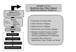
  • 1. DISTRICT PLAN (Rashtriya Sam Vikas Yojana) Backward District Initiatives OBJECTIVE Ø PREPARATION OF THREE YEARS MASTER PLAN BASIS SWOT * Strength Ø Preparation of Location Map ANALYSIS * Weaknesses * Opportunities Ø Natural Resources Mapping * Threat Ø Human Resources Mapping STEPS Ø Infrastructure and Amenities Mapping Ø Database of Special Economic Activities Resource Inventory Strengths, Weaknesses, Opportunities, Threats and identification of critical gaps Strength of the District Ø Association Map of Resources, Infrastructure, Gaps, Priorities and Models Identification of Critical Areas Schemes to fill up these Gaps
  • 2. 1. Preparation of Location Map 2. Data and Mapping of population, density, socio-economic indicators socio- 3. Natural Resources Mapping i) Landuse/Land Landuse/Land Cover ii) Forest iii) Drainage (Rivers and Streams) iv) Water Resources (Reservoirs, Lakes, Tanks, etc.) etc. v) Soil vi) Slope vii) Geomorphology/ hyderogeomorphology Geomorphology/hyderogeomorphology viii) Geology
  • 3. 4. Human Resources Mapping i) Population Distribution • ii) Literacy • iii) Educational Levels • iv) Technical Education/ Skilled Manpower Reserves • v) Population in the working age group • vi) Unemployment/Underemployment • vii) Poverty (BPL)
  • 4. 5. Infrastructure and Amenities Mapping i) Roads/Connectivity ii) Railways iii) Telecommunication iv) Irrigation v) Agricultural Implements vi) Credit Facilities vii) Seeds/HYV/Fertilizer/Pesticide Distribution or Sale Centre/Shop viii) Hospitals and Health Centres ix) Other Health Facilities x) Schools and Educational Centres xi) Vocational/Training Institute (Polytechnic/ITI) xii) Research Institute xiii) Housing xiv) Electricity xv) Access to Safe Drinking Water Facility xvi) Toilet xvii) Environmental Health
  • 5. 6. Database of NGOs and Self Help Groups 7. Database of Special Economic Activities of the District 8. Strengths, Weaknesses, Opportunities, Threats & identification of critical gaps • i) Strengths and Weaknesses • ii) Areas of Special Attention • iii) Identification and Distribution of Target Areas/Groups or Communities • iv) Identification of Lead Sectors/ Sick Sectors • v) Critical Gaps
  • 6. 9. Association Map of Resources, Infrastructure, Gaps, Priorities and Models i) Land and Water Management (Check Dams, Revitalization of Traditional Water Structures, Small Lift Irrigation Projects, Mini-Diversion Weirs, etc. Mini- etc. ii) Health Infrastructure (Location of PHC, Sub-Centres, ANM, Anganwadi Sub-Centres, Centres strengthen Health Care System for proper Preventive, Promotive and Curative Health Care, Institutional Deliveries and Medical Assistance at Birth. Birth. iii) Educational Infrastructure at proper location iv) Vocational Training Centres (Projection and Location for Job Market and Self Employment) v) Increase in Income by agriculture and allied activities through the identification of agriculture and horticulture practices, dry land farming, improving yields from dairying, animal husbandry, pisciculture, etc, pisciculture, veterinary and credit and market facilities (Suggestion for suitable lands, areas, etc.) etc. vi) Filling critical gaps in above areas
  • 7. Village Information System (VIS) “The Village Information System (VIS) is an integrated system of Spatial and Non Spatial Database and Customized GIS Softwares to generate and integrate comprehensive information on all aspects of development at Village, Panchayat, Block, District and State Level administrative units using Space Technology to help formulate a proper development strategy in order to meet the service gaps and strengthen overall rural development.”
  • 8. VIEW OF NAMKUM BLOCK FROM SATELLITE
  • 9.
  • 10.
  • 11. NAMKUM BLOCK M GEOMORP PHOLOGY 200 04 c k . B lo e C.D Kank Ang N ara W E C. D. Bl ck S o ck Blo D. C. n ia Ra ck Bl o . D. C rra Ka Index DENUDATIONAL HILL HIL L TOP WEATHERED ck lo INSELBERG .B .D INTERMONTANE VALLEY C u LATERITIC PLAIN MODERATE nd Bu PEDIMENT INSELBERG COMPLEX PL ATEAU MODERATELY DISSECTED PL ATEAU WEATHERED MODERATE PL ATEAU WEATHERED SHALLOW RESERVOIR K hunti C.D. Bloc k RESIDUAL HILL RIVER STRUCTURAL HILL Kilo ometers VALLEY 5 0 5 VALLEY FILL SHALLOW VALLEY GULLY