SlideShare a Scribd company logo
1 of 1
Download to read offline
692863
692863
693363
693363
693863
693863
694363
694363
694863
694863
695363
695363
695863
695863
696363
696363
4913940
4914440
4914440
4914940
4914940
4915440
4915440
4915940
4915940
4916440
4916440
4916940
4916940
4917440
4917440
4917940
4917940
Shamrock Road
¯
Emily Landfill - Surveyed Data
JMTConsultants
Data Source Information: ArcGIS layers acquired from Geogratis
online.
Elevation data obtained by total station survey
Coordinate system: UTM NAD 83 zone 17
Dislaimer: The locations of the Lagoons,
Mound and Road to lagoons are all approximate.
No benchmarks were used in the creation of this map.
1:20,185
Project Group # 775

More Related Content

What's hot

Meshing and Simplification of High Resolution Urban Surface Data for UAV Path...
Meshing and Simplification of High Resolution Urban Surface Data for UAV Path...Meshing and Simplification of High Resolution Urban Surface Data for UAV Path...
Meshing and Simplification of High Resolution Urban Surface Data for UAV Path...Florian-Michael Adolf
 
OpenStreetMap Brighton 1.0, part1
OpenStreetMap Brighton 1.0, part1OpenStreetMap Brighton 1.0, part1
OpenStreetMap Brighton 1.0, part1mikel_maron
 
Feasibility study presentation
Feasibility study presentationFeasibility study presentation
Feasibility study presentationE'ville Eye
 
Web Based Gis For Land Administration 20090629
Web Based Gis For Land Administration 20090629Web Based Gis For Land Administration 20090629
Web Based Gis For Land Administration 20090629John Reitsma
 
Airborne vehicle detection in dense urban areas using ho g features and dispa...
Airborne vehicle detection in dense urban areas using ho g features and dispa...Airborne vehicle detection in dense urban areas using ho g features and dispa...
Airborne vehicle detection in dense urban areas using ho g features and dispa...Ecway Technologies
 
United Maps - Company Profile and Technology Overview (CN)
United Maps - Company Profile and Technology Overview (CN)United Maps - Company Profile and Technology Overview (CN)
United Maps - Company Profile and Technology Overview (CN)Stefan Knecht
 
Final Drawing Submittal
Final Drawing SubmittalFinal Drawing Submittal
Final Drawing SubmittalBrian Weaver
 
Mapping vehicle emissions through streets and intersections application of ...
Mapping vehicle emissions through streets and intersections   application of ...Mapping vehicle emissions through streets and intersections   application of ...
Mapping vehicle emissions through streets and intersections application of ...Institute for Transport Studies (ITS)
 
MiPlEx - Online Task Planning for Exploration Tasks in Urban Terrain
MiPlEx - Online Task Planning for Exploration Tasks in Urban TerrainMiPlEx - Online Task Planning for Exploration Tasks in Urban Terrain
MiPlEx - Online Task Planning for Exploration Tasks in Urban TerrainFlorian-Michael Adolf
 
El programa Galileo de la Agencia Espacial Europea
El programa Galileo de la Agencia Espacial EuropeaEl programa Galileo de la Agencia Espacial Europea
El programa Galileo de la Agencia Espacial EuropeaAMETIC
 
4 gis applications mon map
4   gis applications mon map4   gis applications mon map
4 gis applications mon mapGeoMedeelel
 
De Santana, Mourão Moura, Marques & Moraes - input2012
De Santana, Mourão Moura, Marques & Moraes - input2012De Santana, Mourão Moura, Marques & Moraes - input2012
De Santana, Mourão Moura, Marques & Moraes - input2012INPUT 2012
 
EDIT GeoTools presentation in TDWG 2009 (Montpellier)
EDIT GeoTools presentation in TDWG 2009 (Montpellier)EDIT GeoTools presentation in TDWG 2009 (Montpellier)
EDIT GeoTools presentation in TDWG 2009 (Montpellier)Pere Roca Ristol
 

What's hot (18)

Meshing and Simplification of High Resolution Urban Surface Data for UAV Path...
Meshing and Simplification of High Resolution Urban Surface Data for UAV Path...Meshing and Simplification of High Resolution Urban Surface Data for UAV Path...
Meshing and Simplification of High Resolution Urban Surface Data for UAV Path...
 
OpenStreetMap Brighton 1.0, part1
OpenStreetMap Brighton 1.0, part1OpenStreetMap Brighton 1.0, part1
OpenStreetMap Brighton 1.0, part1
 
Feasibility study presentation
Feasibility study presentationFeasibility study presentation
Feasibility study presentation
 
UC2014
UC2014UC2014
UC2014
 
Web Based Gis For Land Administration 20090629
Web Based Gis For Land Administration 20090629Web Based Gis For Land Administration 20090629
Web Based Gis For Land Administration 20090629
 
Airborne vehicle detection in dense urban areas using ho g features and dispa...
Airborne vehicle detection in dense urban areas using ho g features and dispa...Airborne vehicle detection in dense urban areas using ho g features and dispa...
Airborne vehicle detection in dense urban areas using ho g features and dispa...
 
United Maps - Company Profile and Technology Overview (CN)
United Maps - Company Profile and Technology Overview (CN)United Maps - Company Profile and Technology Overview (CN)
United Maps - Company Profile and Technology Overview (CN)
 
Final Drawing Submittal
Final Drawing SubmittalFinal Drawing Submittal
Final Drawing Submittal
 
Defining Cambridge
Defining CambridgeDefining Cambridge
Defining Cambridge
 
presentation
presentationpresentation
presentation
 
Mapping vehicle emissions through streets and intersections application of ...
Mapping vehicle emissions through streets and intersections   application of ...Mapping vehicle emissions through streets and intersections   application of ...
Mapping vehicle emissions through streets and intersections application of ...
 
Will There be Space?
Will There be Space?Will There be Space?
Will There be Space?
 
MiPlEx - Online Task Planning for Exploration Tasks in Urban Terrain
MiPlEx - Online Task Planning for Exploration Tasks in Urban TerrainMiPlEx - Online Task Planning for Exploration Tasks in Urban Terrain
MiPlEx - Online Task Planning for Exploration Tasks in Urban Terrain
 
“How QuantCube Technology uses alternative data to create macroeconomic, fina...
“How QuantCube Technology uses alternative data to create macroeconomic, fina...“How QuantCube Technology uses alternative data to create macroeconomic, fina...
“How QuantCube Technology uses alternative data to create macroeconomic, fina...
 
El programa Galileo de la Agencia Espacial Europea
El programa Galileo de la Agencia Espacial EuropeaEl programa Galileo de la Agencia Espacial Europea
El programa Galileo de la Agencia Espacial Europea
 
4 gis applications mon map
4   gis applications mon map4   gis applications mon map
4 gis applications mon map
 
De Santana, Mourão Moura, Marques & Moraes - input2012
De Santana, Mourão Moura, Marques & Moraes - input2012De Santana, Mourão Moura, Marques & Moraes - input2012
De Santana, Mourão Moura, Marques & Moraes - input2012
 
EDIT GeoTools presentation in TDWG 2009 (Montpellier)
EDIT GeoTools presentation in TDWG 2009 (Montpellier)EDIT GeoTools presentation in TDWG 2009 (Montpellier)
EDIT GeoTools presentation in TDWG 2009 (Montpellier)
 

Viewers also liked

Viewers also liked (7)

GeovisMtStHelens2
GeovisMtStHelens2GeovisMtStHelens2
GeovisMtStHelens2
 
DEMFINAL
DEMFINALDEMFINAL
DEMFINAL
 
CasinoMine
CasinoMineCasinoMine
CasinoMine
 
NewfoundlandProject3
NewfoundlandProject3NewfoundlandProject3
NewfoundlandProject3
 
Ontario
OntarioOntario
Ontario
 
GPSvsSurveyFINAL
GPSvsSurveyFINALGPSvsSurveyFINAL
GPSvsSurveyFINAL
 
3DMap
3DMap3DMap
3DMap
 

OverlayedGoogleFINAL
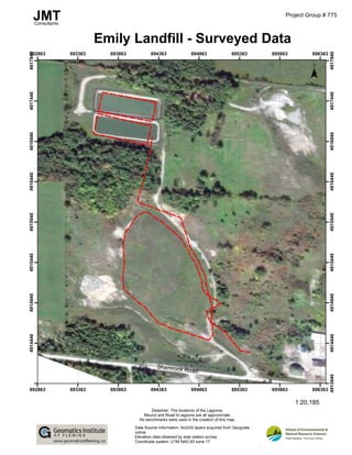