SlideShare a Scribd company logo
1 of 2
Download to read offline
Optical Remote Sensing


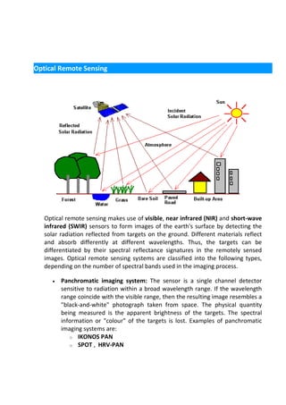
   Optical remote sensing makes use of visible, near infrared (NIR) and short-wave
   infrared (SWIR) sensors to form images of the earth's surface by detecting the
   solar radiation reflected from targets on the ground. Different materials reflect
   and absorb differently at different wavelengths. Thus, the targets can be
   differentiated by their spectral reflectance signatures in the remotely sensed
   images. Optical remote sensing systems are classified into the following types,
   depending on the number of spectral bands used in the imaging process.

      •   Panchromatic imaging system: The sensor is a single channel detector
          sensitive to radiation within a broad wavelength range. If the wavelength
          range coincide with the visible range, then the resulting image resembles a
          "black-and-white" photograph taken from space. The physical quantity
          being measured is the apparent brightness of the targets. The spectral
          information or "colour" of the targets is lost. Examples of panchromatic
          imaging systems are:
             o IKONOS PAN
             o SPOT , HRV-PAN
•   Multispectral imaging system: The sensor is a multichannel detector with
    a few spectral bands. Each channel is sensitive to radiation within a narrow
    wavelength band. The resulting image is a multilayer image which contains
    both the brightness and spectral (colour) information of the targets being
    observed. Examples of multispectral systems are:
        o LANDSAT MSS
        o LANDSAT TM
        o SPOT , HRV-XS
        o IKONOS MS


•   Superspectral Imaging Systems: A superspectral imaging sensor has many
    more spectral channels (typically >10) than a multispectral sensor. The
    bands have narrower bandwidths, enabling the finer spectral
    characteristics of the targets to be captured by the sensor. Examples of
    superspectral systems are:
       o MODIS
       o MERIS


•   Hyperspectral Imaging Systems: A hyperspectral imaging system is also
    known as an "imaging spectrometer". it acquires images in about a
    hundred or more contiguous spectral bands. The precise spectral
    information contained in a hyperspectral image enables better
    characterisation and identification of targets. Hyperspectral images have
    potential applications in such fields as precision agriculture (e.g.
    monitoring the types, health, moisture status and maturity of crops),
    coastal management (e.g. monitoring of phytoplanktons, pollution,
    bathymetry changes). An example of a hyperspectral system is:
       o Hyperion on EO1 satellite

More Related Content

What's hot

Remote Sensing - Fundamentals
Remote Sensing - FundamentalsRemote Sensing - Fundamentals
Remote Sensing - FundamentalsAjay Singh Lodhi
 
Introduction to Remote Sensing- by Wankie Richman
Introduction to Remote Sensing- by Wankie RichmanIntroduction to Remote Sensing- by Wankie Richman
Introduction to Remote Sensing- by Wankie RichmanRichmanWankie
 
Scanners, image resolution, orbit in remote sensing, pk mani
Scanners, image resolution, orbit in remote sensing, pk maniScanners, image resolution, orbit in remote sensing, pk mani
Scanners, image resolution, orbit in remote sensing, pk maniP.K. Mani
 
Sensors for remote sensing
Sensors for remote sensingSensors for remote sensing
Sensors for remote sensingMohsin Siddique
 
Remote Sensing
Remote SensingRemote Sensing
Remote Sensingguest7b3693
 
Basics of remote sensing, pk mani
Basics of remote sensing, pk maniBasics of remote sensing, pk mani
Basics of remote sensing, pk maniP.K. Mani
 
Chapter 5: Remote sensing
Chapter 5: Remote sensingChapter 5: Remote sensing
Chapter 5: Remote sensingShankar Gangaju
 
Optical and infrared remote sensing
Optical and infrared remote sensingOptical and infrared remote sensing
Optical and infrared remote sensingNeha Sharma
 
Lecture for landsat
Lecture for landsatLecture for landsat
Lecture for landsatGeoMedeelel
 
Remote Sensing Platforms and Its types
Remote Sensing Platforms and Its typesRemote Sensing Platforms and Its types
Remote Sensing Platforms and Its typesSenthamizhan M
 
Radar remote sensing, P K MANI
Radar remote sensing, P K MANIRadar remote sensing, P K MANI
Radar remote sensing, P K MANIP.K. Mani
 
Digital image processing
Digital image processingDigital image processing
Digital image processingVandana Verma
 
Remote sensing and image interpretation
Remote sensing and image interpretationRemote sensing and image interpretation
Remote sensing and image interpretationMd. Nazir Hossain
 
Thermal Remote Sensing
Thermal Remote SensingThermal Remote Sensing
Thermal Remote SensingRohit Kumar
 
Passive and active sensors
Passive and active sensorsPassive and active sensors
Passive and active sensorsVivek Srivastava
 
Fundamentals of Remote Sensing
Fundamentals of Remote SensingFundamentals of Remote Sensing
Fundamentals of Remote SensingShah Naseer
 
Digital image processing
Digital image processingDigital image processing
Digital image processinglakhveer singh
 
Remote sensing - Scanners
Remote sensing - ScannersRemote sensing - Scanners
Remote sensing - ScannersPramoda Raj
 

What's hot (20)

Remote Sensing - Fundamentals
Remote Sensing - FundamentalsRemote Sensing - Fundamentals
Remote Sensing - Fundamentals
 
Introduction to Remote Sensing- by Wankie Richman
Introduction to Remote Sensing- by Wankie RichmanIntroduction to Remote Sensing- by Wankie Richman
Introduction to Remote Sensing- by Wankie Richman
 
Scanners, image resolution, orbit in remote sensing, pk mani
Scanners, image resolution, orbit in remote sensing, pk maniScanners, image resolution, orbit in remote sensing, pk mani
Scanners, image resolution, orbit in remote sensing, pk mani
 
Sensors for remote sensing
Sensors for remote sensingSensors for remote sensing
Sensors for remote sensing
 
remote sensing
remote sensingremote sensing
remote sensing
 
Remote Sensing
Remote SensingRemote Sensing
Remote Sensing
 
Basics of remote sensing, pk mani
Basics of remote sensing, pk maniBasics of remote sensing, pk mani
Basics of remote sensing, pk mani
 
Chapter 5: Remote sensing
Chapter 5: Remote sensingChapter 5: Remote sensing
Chapter 5: Remote sensing
 
Optical and infrared remote sensing
Optical and infrared remote sensingOptical and infrared remote sensing
Optical and infrared remote sensing
 
Lecture for landsat
Lecture for landsatLecture for landsat
Lecture for landsat
 
Remote Sensing Platforms and Its types
Remote Sensing Platforms and Its typesRemote Sensing Platforms and Its types
Remote Sensing Platforms and Its types
 
Radar remote sensing, P K MANI
Radar remote sensing, P K MANIRadar remote sensing, P K MANI
Radar remote sensing, P K MANI
 
Remote sensing
Remote sensingRemote sensing
Remote sensing
 
Digital image processing
Digital image processingDigital image processing
Digital image processing
 
Remote sensing and image interpretation
Remote sensing and image interpretationRemote sensing and image interpretation
Remote sensing and image interpretation
 
Thermal Remote Sensing
Thermal Remote SensingThermal Remote Sensing
Thermal Remote Sensing
 
Passive and active sensors
Passive and active sensorsPassive and active sensors
Passive and active sensors
 
Fundamentals of Remote Sensing
Fundamentals of Remote SensingFundamentals of Remote Sensing
Fundamentals of Remote Sensing
 
Digital image processing
Digital image processingDigital image processing
Digital image processing
 
Remote sensing - Scanners
Remote sensing - ScannersRemote sensing - Scanners
Remote sensing - Scanners
 

Similar to Optical remote sensing

Remote sensing - Sensors, Platforms and Satellite orbits
Remote sensing - Sensors, Platforms and Satellite orbitsRemote sensing - Sensors, Platforms and Satellite orbits
Remote sensing - Sensors, Platforms and Satellite orbitsAjay Singh Lodhi
 
Resolution and scanning system
Resolution and scanning systemResolution and scanning system
Resolution and scanning systemAglaia Connect
 
SENSORS AND SCANNERS.pptx
SENSORS AND SCANNERS.pptxSENSORS AND SCANNERS.pptx
SENSORS AND SCANNERS.pptxthanga2
 
RS - Presentation by AP2023.pptx
RS - Presentation by AP2023.pptxRS - Presentation by AP2023.pptx
RS - Presentation by AP2023.pptxDrAbhishekPandey9
 
Basics of Remote Sensing
Basics of Remote SensingBasics of Remote Sensing
Basics of Remote SensingAkash Tikhe
 
Surveying ii ajith sir class4
Surveying ii ajith sir class4Surveying ii ajith sir class4
Surveying ii ajith sir class4SHAMJITH KM
 
Remote Sensing: Meaning, Concept and Components | Geography
Remote Sensing: Meaning, Concept and Components | GeographyRemote Sensing: Meaning, Concept and Components | Geography
Remote Sensing: Meaning, Concept and Components | GeographySrimantaKarak
 
Hyperspectral & Remote Sensing on Remote Sensing and GIS.pptx
Hyperspectral & Remote Sensing on Remote Sensing and GIS.pptxHyperspectral & Remote Sensing on Remote Sensing and GIS.pptx
Hyperspectral & Remote Sensing on Remote Sensing and GIS.pptxKabaliVasudevasu
 
rsbasics-150227022648-conversion-gate01.pptx
rsbasics-150227022648-conversion-gate01.pptxrsbasics-150227022648-conversion-gate01.pptx
rsbasics-150227022648-conversion-gate01.pptxBSuresh26
 
Remote sensing: Its Application & Types
Remote sensing: Its Application & TypesRemote sensing: Its Application & Types
Remote sensing: Its Application & Typesasdfg484362
 
Photoacustic Imaging
Photoacustic ImagingPhotoacustic Imaging
Photoacustic Imagingelmira yazdani
 
RADIOMETRIC RESOLUTION.pptx
RADIOMETRIC RESOLUTION.pptxRADIOMETRIC RESOLUTION.pptx
RADIOMETRIC RESOLUTION.pptxKuki Boruah
 
sources of imges
sources of imgessources of imges
sources of imgesFum Pan Javars
 
DSP FINALs
DSP FINALsDSP FINALs
DSP FINALs1107atlas
 
Remote Sensin
Remote SensinRemote Sensin
Remote Sensinguest7b3693
 
Application of Remote Sensing And GIS ..
Application of Remote Sensing And GIS ..Application of Remote Sensing And GIS ..
Application of Remote Sensing And GIS ..binitaayadv0522
 
Remote sensing
Remote sensingRemote sensing
Remote sensingMohamed Salah
 
Resolution.pptx remote sensing resolution
Resolution.pptx remote sensing resolutionResolution.pptx remote sensing resolution
Resolution.pptx remote sensing resolutionaaravpatel29
 
A Infrared hyperspectral imaging technique for non-invasive cancer detection.
A Infrared hyperspectral imaging technique for non-invasive cancer detection.A Infrared hyperspectral imaging technique for non-invasive cancer detection.
A Infrared hyperspectral imaging technique for non-invasive cancer detection.IJERD Editor
 

Similar to Optical remote sensing (20)

Remote sensing - Sensors, Platforms and Satellite orbits
Remote sensing - Sensors, Platforms and Satellite orbitsRemote sensing - Sensors, Platforms and Satellite orbits
Remote sensing - Sensors, Platforms and Satellite orbits
 
Resolution and scanning system
Resolution and scanning systemResolution and scanning system
Resolution and scanning system
 
SENSORS AND SCANNERS.pptx
SENSORS AND SCANNERS.pptxSENSORS AND SCANNERS.pptx
SENSORS AND SCANNERS.pptx
 
RS - Presentation by AP2023.pptx
RS - Presentation by AP2023.pptxRS - Presentation by AP2023.pptx
RS - Presentation by AP2023.pptx
 
Basics of Remote Sensing
Basics of Remote SensingBasics of Remote Sensing
Basics of Remote Sensing
 
Surveying ii ajith sir class4
Surveying ii ajith sir class4Surveying ii ajith sir class4
Surveying ii ajith sir class4
 
Remote Sensing: Meaning, Concept and Components | Geography
Remote Sensing: Meaning, Concept and Components | GeographyRemote Sensing: Meaning, Concept and Components | Geography
Remote Sensing: Meaning, Concept and Components | Geography
 
Hyperspectral & Remote Sensing on Remote Sensing and GIS.pptx
Hyperspectral & Remote Sensing on Remote Sensing and GIS.pptxHyperspectral & Remote Sensing on Remote Sensing and GIS.pptx
Hyperspectral & Remote Sensing on Remote Sensing and GIS.pptx
 
rsbasics-150227022648-conversion-gate01.pptx
rsbasics-150227022648-conversion-gate01.pptxrsbasics-150227022648-conversion-gate01.pptx
rsbasics-150227022648-conversion-gate01.pptx
 
Remote sensing: Its Application & Types
Remote sensing: Its Application & TypesRemote sensing: Its Application & Types
Remote sensing: Its Application & Types
 
Photoacustic Imaging
Photoacustic ImagingPhotoacustic Imaging
Photoacustic Imaging
 
RADIOMETRIC RESOLUTION.pptx
RADIOMETRIC RESOLUTION.pptxRADIOMETRIC RESOLUTION.pptx
RADIOMETRIC RESOLUTION.pptx
 
sources of imges
sources of imgessources of imges
sources of imges
 
DSP FINALs
DSP FINALsDSP FINALs
DSP FINALs
 
Remote Sensin
Remote SensinRemote Sensin
Remote Sensin
 
Application of Remote Sensing And GIS ..
Application of Remote Sensing And GIS ..Application of Remote Sensing And GIS ..
Application of Remote Sensing And GIS ..
 
Remote sensing
Remote sensingRemote sensing
Remote sensing
 
Resolution.pptx remote sensing resolution
Resolution.pptx remote sensing resolutionResolution.pptx remote sensing resolution
Resolution.pptx remote sensing resolution
 
A Infrared hyperspectral imaging technique for non-invasive cancer detection.
A Infrared hyperspectral imaging technique for non-invasive cancer detection.A Infrared hyperspectral imaging technique for non-invasive cancer detection.
A Infrared hyperspectral imaging technique for non-invasive cancer detection.
 
Remote sensing
Remote sensingRemote sensing
Remote sensing
 

More from Sumant Diwakar

Hydrologic Assessment in a Middle Narmada Basin, India using SWAT Model
Hydrologic Assessment in a Middle Narmada Basin, India using SWAT ModelHydrologic Assessment in a Middle Narmada Basin, India using SWAT Model
Hydrologic Assessment in a Middle Narmada Basin, India using SWAT ModelSumant Diwakar
 
REMOTE SENSING & GIS APPLICATIONS IN WATERSHED MANAGEMENT
REMOTE SENSING & GIS APPLICATIONS IN WATERSHED MANAGEMENT REMOTE SENSING & GIS APPLICATIONS IN WATERSHED MANAGEMENT
REMOTE SENSING & GIS APPLICATIONS IN WATERSHED MANAGEMENT Sumant Diwakar
 
Relation between Ground-based Soil Moisture and Satellite Image-based NDVI
Relation between Ground-based Soil Moisture and Satellite Image-based NDVIRelation between Ground-based Soil Moisture and Satellite Image-based NDVI
Relation between Ground-based Soil Moisture and Satellite Image-based NDVISumant Diwakar
 
Solar irradiation & spectral signature
Solar irradiation & spectral signatureSolar irradiation & spectral signature
Solar irradiation & spectral signatureSumant Diwakar
 
Interaction of EMR with atmosphere and earth surface
Interaction of EMR with atmosphere and earth surfaceInteraction of EMR with atmosphere and earth surface
Interaction of EMR with atmosphere and earth surfaceSumant Diwakar
 
History of remote sensing
History of remote sensingHistory of remote sensing
History of remote sensingSumant Diwakar
 
Electromagnetic radiation
Electromagnetic radiationElectromagnetic radiation
Electromagnetic radiationSumant Diwakar
 
Differential gps (dgps) 09 04-12
Differential gps (dgps) 09 04-12Differential gps (dgps) 09 04-12
Differential gps (dgps) 09 04-12Sumant Diwakar
 
Principle of photogrammetry
Principle of photogrammetryPrinciple of photogrammetry
Principle of photogrammetrySumant Diwakar
 
Digital terrain model
Digital terrain modelDigital terrain model
Digital terrain modelSumant Diwakar
 
Digital orthophoto
Digital orthophotoDigital orthophoto
Digital orthophotoSumant Diwakar
 
Automatic digital terrain modelling
Automatic digital terrain modellingAutomatic digital terrain modelling
Automatic digital terrain modellingSumant Diwakar
 
Aerial photography abraham thomas
Aerial photography abraham thomasAerial photography abraham thomas
Aerial photography abraham thomasSumant Diwakar
 
Aerial photographs and their interpretation
Aerial photographs and their interpretationAerial photographs and their interpretation
Aerial photographs and their interpretationSumant Diwakar
 
Wide field sensor
Wide field sensorWide field sensor
Wide field sensorSumant Diwakar
 

More from Sumant Diwakar (20)

Hydrologic Assessment in a Middle Narmada Basin, India using SWAT Model
Hydrologic Assessment in a Middle Narmada Basin, India using SWAT ModelHydrologic Assessment in a Middle Narmada Basin, India using SWAT Model
Hydrologic Assessment in a Middle Narmada Basin, India using SWAT Model
 
C Programming
C ProgrammingC Programming
C Programming
 
C Programming
C ProgrammingC Programming
C Programming
 
Soil moisture
Soil moistureSoil moisture
Soil moisture
 
REMOTE SENSING & GIS APPLICATIONS IN WATERSHED MANAGEMENT
REMOTE SENSING & GIS APPLICATIONS IN WATERSHED MANAGEMENT REMOTE SENSING & GIS APPLICATIONS IN WATERSHED MANAGEMENT
REMOTE SENSING & GIS APPLICATIONS IN WATERSHED MANAGEMENT
 
Relation between Ground-based Soil Moisture and Satellite Image-based NDVI
Relation between Ground-based Soil Moisture and Satellite Image-based NDVIRelation between Ground-based Soil Moisture and Satellite Image-based NDVI
Relation between Ground-based Soil Moisture and Satellite Image-based NDVI
 
Solar irradiation & spectral signature
Solar irradiation & spectral signatureSolar irradiation & spectral signature
Solar irradiation & spectral signature
 
Interaction of EMR with atmosphere and earth surface
Interaction of EMR with atmosphere and earth surfaceInteraction of EMR with atmosphere and earth surface
Interaction of EMR with atmosphere and earth surface
 
History of remote sensing
History of remote sensingHistory of remote sensing
History of remote sensing
 
Electromagnetic radiation
Electromagnetic radiationElectromagnetic radiation
Electromagnetic radiation
 
Map projection
Map projectionMap projection
Map projection
 
Differential gps (dgps) 09 04-12
Differential gps (dgps) 09 04-12Differential gps (dgps) 09 04-12
Differential gps (dgps) 09 04-12
 
Principle of photogrammetry
Principle of photogrammetryPrinciple of photogrammetry
Principle of photogrammetry
 
Digital terrain model
Digital terrain modelDigital terrain model
Digital terrain model
 
Digital orthophoto
Digital orthophotoDigital orthophoto
Digital orthophoto
 
Automatic digital terrain modelling
Automatic digital terrain modellingAutomatic digital terrain modelling
Automatic digital terrain modelling
 
Aerial photography abraham thomas
Aerial photography abraham thomasAerial photography abraham thomas
Aerial photography abraham thomas
 
Aerial photographs and their interpretation
Aerial photographs and their interpretationAerial photographs and their interpretation
Aerial photographs and their interpretation
 
Wide field sensor
Wide field sensorWide field sensor
Wide field sensor
 
Thematic mapper
Thematic mapperThematic mapper
Thematic mapper
 

Recently uploaded

Man or Manufactured_ Redefining Humanity Through Biopunk Narratives.pptx
Man or Manufactured_ Redefining Humanity Through Biopunk Narratives.pptxMan or Manufactured_ Redefining Humanity Through Biopunk Narratives.pptx
Man or Manufactured_ Redefining Humanity Through Biopunk Narratives.pptxDhatriParmar
 
Mental Health Awareness - a toolkit for supporting young minds
Mental Health Awareness - a toolkit for supporting young mindsMental Health Awareness - a toolkit for supporting young minds
Mental Health Awareness - a toolkit for supporting young mindsPooky Knightsmith
 
Visit to a blind student's school🧑‍🦯🧑‍🦯(community medicine)
Visit to a blind student's school🧑‍🦯🧑‍🦯(community medicine)Visit to a blind student's school🧑‍🦯🧑‍🦯(community medicine)
Visit to a blind student's school🧑‍🦯🧑‍🦯(community medicine)lakshayb543
 
Measures of Position DECILES for ungrouped data
Measures of Position DECILES for ungrouped dataMeasures of Position DECILES for ungrouped data
Measures of Position DECILES for ungrouped dataBabyAnnMotar
 
Blowin' in the Wind of Caste_ Bob Dylan's Song as a Catalyst for Social Justi...
Blowin' in the Wind of Caste_ Bob Dylan's Song as a Catalyst for Social Justi...Blowin' in the Wind of Caste_ Bob Dylan's Song as a Catalyst for Social Justi...
Blowin' in the Wind of Caste_ Bob Dylan's Song as a Catalyst for Social Justi...DhatriParmar
 
Using Grammatical Signals Suitable to Patterns of Idea Development
Using Grammatical Signals Suitable to Patterns of Idea DevelopmentUsing Grammatical Signals Suitable to Patterns of Idea Development
Using Grammatical Signals Suitable to Patterns of Idea Developmentchesterberbo7
 
4.11.24 Poverty and Inequality in America.pptx
4.11.24 Poverty and Inequality in America.pptx4.11.24 Poverty and Inequality in America.pptx
4.11.24 Poverty and Inequality in America.pptxmary850239
 
How to Make a Duplicate of Your Odoo 17 Database
How to Make a Duplicate of Your Odoo 17 DatabaseHow to Make a Duplicate of Your Odoo 17 Database
How to Make a Duplicate of Your Odoo 17 DatabaseCeline George
 
ESP 4-EDITED.pdfmmcncncncmcmmnmnmncnmncmnnjvnnv
ESP 4-EDITED.pdfmmcncncncmcmmnmnmncnmncmnnjvnnvESP 4-EDITED.pdfmmcncncncmcmmnmnmncnmncmnnjvnnv
ESP 4-EDITED.pdfmmcncncncmcmmnmnmncnmncmnnjvnnvRicaMaeCastro1
 
Scientific Writing :Research Discourse
Scientific  Writing :Research  DiscourseScientific  Writing :Research  Discourse
Scientific Writing :Research DiscourseAnita GoswamiGiri
 
ClimART Action | eTwinning Project
ClimART Action    |    eTwinning ProjectClimART Action    |    eTwinning Project
ClimART Action | eTwinning Projectjordimapav
 
Active Learning Strategies (in short ALS).pdf
Active Learning Strategies (in short ALS).pdfActive Learning Strategies (in short ALS).pdf
Active Learning Strategies (in short ALS).pdfPatidar M
 
Congestive Cardiac Failure..presentation
Congestive Cardiac Failure..presentationCongestive Cardiac Failure..presentation
Congestive Cardiac Failure..presentationdeepaannamalai16
 
Beauty Amidst the Bytes_ Unearthing Unexpected Advantages of the Digital Wast...
Beauty Amidst the Bytes_ Unearthing Unexpected Advantages of the Digital Wast...Beauty Amidst the Bytes_ Unearthing Unexpected Advantages of the Digital Wast...
Beauty Amidst the Bytes_ Unearthing Unexpected Advantages of the Digital Wast...DhatriParmar
 
DIFFERENT BASKETRY IN THE PHILIPPINES PPT.pptx
DIFFERENT BASKETRY IN THE PHILIPPINES PPT.pptxDIFFERENT BASKETRY IN THE PHILIPPINES PPT.pptx
DIFFERENT BASKETRY IN THE PHILIPPINES PPT.pptxMichelleTuguinay1
 
Narcotic and Non Narcotic Analgesic..pdf
Narcotic and Non Narcotic Analgesic..pdfNarcotic and Non Narcotic Analgesic..pdf
Narcotic and Non Narcotic Analgesic..pdfPrerana Jadhav
 

Recently uploaded (20)

Man or Manufactured_ Redefining Humanity Through Biopunk Narratives.pptx
Man or Manufactured_ Redefining Humanity Through Biopunk Narratives.pptxMan or Manufactured_ Redefining Humanity Through Biopunk Narratives.pptx
Man or Manufactured_ Redefining Humanity Through Biopunk Narratives.pptx
 
Mental Health Awareness - a toolkit for supporting young minds
Mental Health Awareness - a toolkit for supporting young mindsMental Health Awareness - a toolkit for supporting young minds
Mental Health Awareness - a toolkit for supporting young minds
 
Faculty Profile prashantha K EEE dept Sri Sairam college of Engineering
Faculty Profile prashantha K EEE dept Sri Sairam college of EngineeringFaculty Profile prashantha K EEE dept Sri Sairam college of Engineering
Faculty Profile prashantha K EEE dept Sri Sairam college of Engineering
 
Visit to a blind student's school🧑‍🦯🧑‍🦯(community medicine)
Visit to a blind student's school🧑‍🦯🧑‍🦯(community medicine)Visit to a blind student's school🧑‍🦯🧑‍🦯(community medicine)
Visit to a blind student's school🧑‍🦯🧑‍🦯(community medicine)
 
Measures of Position DECILES for ungrouped data
Measures of Position DECILES for ungrouped dataMeasures of Position DECILES for ungrouped data
Measures of Position DECILES for ungrouped data
 
Blowin' in the Wind of Caste_ Bob Dylan's Song as a Catalyst for Social Justi...
Blowin' in the Wind of Caste_ Bob Dylan's Song as a Catalyst for Social Justi...Blowin' in the Wind of Caste_ Bob Dylan's Song as a Catalyst for Social Justi...
Blowin' in the Wind of Caste_ Bob Dylan's Song as a Catalyst for Social Justi...
 
Using Grammatical Signals Suitable to Patterns of Idea Development
Using Grammatical Signals Suitable to Patterns of Idea DevelopmentUsing Grammatical Signals Suitable to Patterns of Idea Development
Using Grammatical Signals Suitable to Patterns of Idea Development
 
4.11.24 Poverty and Inequality in America.pptx
4.11.24 Poverty and Inequality in America.pptx4.11.24 Poverty and Inequality in America.pptx
4.11.24 Poverty and Inequality in America.pptx
 
How to Make a Duplicate of Your Odoo 17 Database
How to Make a Duplicate of Your Odoo 17 DatabaseHow to Make a Duplicate of Your Odoo 17 Database
How to Make a Duplicate of Your Odoo 17 Database
 
ESP 4-EDITED.pdfmmcncncncmcmmnmnmncnmncmnnjvnnv
ESP 4-EDITED.pdfmmcncncncmcmmnmnmncnmncmnnjvnnvESP 4-EDITED.pdfmmcncncncmcmmnmnmncnmncmnnjvnnv
ESP 4-EDITED.pdfmmcncncncmcmmnmnmncnmncmnnjvnnv
 
INCLUSIVE EDUCATION PRACTICES FOR TEACHERS AND TRAINERS.pptx
INCLUSIVE EDUCATION PRACTICES FOR TEACHERS AND TRAINERS.pptxINCLUSIVE EDUCATION PRACTICES FOR TEACHERS AND TRAINERS.pptx
INCLUSIVE EDUCATION PRACTICES FOR TEACHERS AND TRAINERS.pptx
 
Scientific Writing :Research Discourse
Scientific  Writing :Research  DiscourseScientific  Writing :Research  Discourse
Scientific Writing :Research Discourse
 
ClimART Action | eTwinning Project
ClimART Action    |    eTwinning ProjectClimART Action    |    eTwinning Project
ClimART Action | eTwinning Project
 
Paradigm shift in nursing research by RS MEHTA
Paradigm shift in nursing research by RS MEHTAParadigm shift in nursing research by RS MEHTA
Paradigm shift in nursing research by RS MEHTA
 
Active Learning Strategies (in short ALS).pdf
Active Learning Strategies (in short ALS).pdfActive Learning Strategies (in short ALS).pdf
Active Learning Strategies (in short ALS).pdf
 
Congestive Cardiac Failure..presentation
Congestive Cardiac Failure..presentationCongestive Cardiac Failure..presentation
Congestive Cardiac Failure..presentation
 
Beauty Amidst the Bytes_ Unearthing Unexpected Advantages of the Digital Wast...
Beauty Amidst the Bytes_ Unearthing Unexpected Advantages of the Digital Wast...Beauty Amidst the Bytes_ Unearthing Unexpected Advantages of the Digital Wast...
Beauty Amidst the Bytes_ Unearthing Unexpected Advantages of the Digital Wast...
 
DIFFERENT BASKETRY IN THE PHILIPPINES PPT.pptx
DIFFERENT BASKETRY IN THE PHILIPPINES PPT.pptxDIFFERENT BASKETRY IN THE PHILIPPINES PPT.pptx
DIFFERENT BASKETRY IN THE PHILIPPINES PPT.pptx
 
prashanth updated resume 2024 for Teaching Profession
prashanth updated resume 2024 for Teaching Professionprashanth updated resume 2024 for Teaching Profession
prashanth updated resume 2024 for Teaching Profession
 
Narcotic and Non Narcotic Analgesic..pdf
Narcotic and Non Narcotic Analgesic..pdfNarcotic and Non Narcotic Analgesic..pdf
Narcotic and Non Narcotic Analgesic..pdf
 

Optical remote sensing

  • 1. Optical Remote Sensing Optical remote sensing makes use of visible, near infrared (NIR) and short-wave infrared (SWIR) sensors to form images of the earth's surface by detecting the solar radiation reflected from targets on the ground. Different materials reflect and absorb differently at different wavelengths. Thus, the targets can be differentiated by their spectral reflectance signatures in the remotely sensed images. Optical remote sensing systems are classified into the following types, depending on the number of spectral bands used in the imaging process. • Panchromatic imaging system: The sensor is a single channel detector sensitive to radiation within a broad wavelength range. If the wavelength range coincide with the visible range, then the resulting image resembles a "black-and-white" photograph taken from space. The physical quantity being measured is the apparent brightness of the targets. The spectral information or "colour" of the targets is lost. Examples of panchromatic imaging systems are: o IKONOS PAN o SPOT , HRV-PAN
  • 2. • Multispectral imaging system: The sensor is a multichannel detector with a few spectral bands. Each channel is sensitive to radiation within a narrow wavelength band. The resulting image is a multilayer image which contains both the brightness and spectral (colour) information of the targets being observed. Examples of multispectral systems are: o LANDSAT MSS o LANDSAT TM o SPOT , HRV-XS o IKONOS MS • Superspectral Imaging Systems: A superspectral imaging sensor has many more spectral channels (typically >10) than a multispectral sensor. The bands have narrower bandwidths, enabling the finer spectral characteristics of the targets to be captured by the sensor. Examples of superspectral systems are: o MODIS o MERIS • Hyperspectral Imaging Systems: A hyperspectral imaging system is also known as an "imaging spectrometer". it acquires images in about a hundred or more contiguous spectral bands. The precise spectral information contained in a hyperspectral image enables better characterisation and identification of targets. Hyperspectral images have potential applications in such fields as precision agriculture (e.g. monitoring the types, health, moisture status and maturity of crops), coastal management (e.g. monitoring of phytoplanktons, pollution, bathymetry changes). An example of a hyperspectral system is: o Hyperion on EO1 satellite