SlideShare uma empresa Scribd logo
1 de 2
Baixar para ler offline
Sensors and Their Specifications


Linear Imaging Self-Scanning System I (LISS-I)

       LISS-I (Linear Imaging self Scanner) was a payload for the IRS-1A satellite.
       This camera operated in four spectral bands. It operated in a push-broom
       scanning mode using a CCD array. Each band used 2 CCD's which were
       staggered in the focal plane. It was again used in IRS-1B. It used 7 bit
       quantization, and had a swath of 148 Kms. Images of LISS-I were extensively
       used in forestry, crop acreage, yeild estimation, drought monitoring, flood
       monitoring etc.

Band Details


                           Swath
              Resolution                  Sensor      Spectral Bands       Revisit
                           Width
                 (m)                     Channels          (µm)             Time
                            (km)

                                         LISS-I-1     0.45-0.52 (blue)
                                         LISS-I-2    0.52-0.59 (green)
                 72            148                                             22
                                         LISS-I-3     0.62-0.68 (red)
                                         LISS-I-4   0.77-0.86 (near IR)


       LISS-II was similar to LISS-I, but with higher spatial resolution and smaller
       swath. it was on payload in three satellites : IRS-1A, IRS-1B, IRS-P2.

                   Band          Wavelength Resolution Swath           Revisit
                                   (µm)        (m)     Width            time
                                                        (km)           (days)
               Band 1 (blue)           0.46 to                74
                                                    36.25                 22
                                     0.52                   (145)
              Band 2 (green)           0.52 to                74
                                                    36.25                 22
                                     0.59                   (145)
               Band 3 (red)            0.62 to                74
                                                    36.25                 22
                                     0.68                   (145)
               Band 4 (NIR)            0.77 to                74
                                                    36.25                 22
                                     0.86                   (145)


S K Diwakar
Sensors and Their Specifications


LISS-III

       The LISS-III (Linear Imaging Self Scanning Sensor) sensor is an optical sensor
       working in four spectral bands (green, red, near infrared and short wave
       infrared). It covers a 141km-wide swath with a resolution of 23 meters in all
       spectral bands.

                  Band            Wavelength      Resolution         Swath      Revisit time
                                    (µm)             (m)             Width        (days)
                                                                      (km)
                Band 1            0.52 to 0.59
                                                   23.5               142               5
              (VIS)
                Band 2            0.62 to 0.68
                                                   23.5               142               5
              (VIS)
                Band 3            0.77 to 0.86
                                                   23.5               142               5
              (NIR)
                Band 4            1.55 to 1.7
                                                   70.5               148               5
              (SWIR)


LISS-IV sensor

       LISS-IV can work either in panchromatic or in multispectral mode with the
       same bands as LISS-III (except SWIR). However, the resolution is much
       better (5.8 m). For Resourcesat-1, the swath width varies from 23.9 km in
       multispectral mode to 70.3 km in panchromatic mode. For Resourcesat-2,
       the multispectral swath is enhanced to 70 km. The linear array sensor can
       be steered up to 26 degrees across-track, enabling stereoscopic imaging.

           Mode                       Spectral band   Resolution  Number of Array
               Panchromatic            0.50 – 0.75 µm  58 x 5.8 m        3


                                                                             Number of
           Mode            Band       Spectral band     Resolution
                                                                             Array
           Multispectral      2        0.52 – 0.59 µm     5.8 x 5.8 m
                              3        0.62 – 0.68 µm     5.8 x 5.8 m               1
                              4        0.77 – 0.86 µm     5.8 x 5.8 m


S K Diwakar

Mais conteúdo relacionado

Mais procurados

Microwave remote sensing
Microwave remote sensingMicrowave remote sensing
Microwave remote sensingMohsin Siddique
 
Remote sensing - Sensors, Platforms and Satellite orbits
Remote sensing - Sensors, Platforms and Satellite orbitsRemote sensing - Sensors, Platforms and Satellite orbits
Remote sensing - Sensors, Platforms and Satellite orbitsAjay Singh Lodhi
 
Microwave remote sensing
Microwave remote sensingMicrowave remote sensing
Microwave remote sensingRohit Kumar
 
Chapter 1 (Introduction to remote sensing)
Chapter 1 (Introduction to remote sensing)Chapter 1 (Introduction to remote sensing)
Chapter 1 (Introduction to remote sensing)Shankar Gangaju
 
Introduction to Landsat
Introduction to LandsatIntroduction to Landsat
Introduction to LandsatNizam GIS
 
Chapter 5: Remote sensing
Chapter 5: Remote sensingChapter 5: Remote sensing
Chapter 5: Remote sensingShankar Gangaju
 
Remote Sensing Platforms and Its types
Remote Sensing Platforms and Its typesRemote Sensing Platforms and Its types
Remote Sensing Platforms and Its typesSenthamizhan M
 
Multispectral remote sensing
Multispectral remote sensingMultispectral remote sensing
Multispectral remote sensingDharmendera Meena
 
Thermal Remote Sensing
Thermal Remote SensingThermal Remote Sensing
Thermal Remote SensingRohit Kumar
 
Geo synchronous and Sun synchronous Satellites
Geo synchronous and Sun synchronous SatellitesGeo synchronous and Sun synchronous Satellites
Geo synchronous and Sun synchronous SatellitesTilok Chetri
 
Spectral signatures
Spectral signaturesSpectral signatures
Spectral signaturesKunal Rathod
 
ENERGY INTERACTIONS WITH EARTH SURFACE FEATURES
 ENERGY INTERACTIONS WITH EARTH SURFACE FEATURES  ENERGY INTERACTIONS WITH EARTH SURFACE FEATURES
ENERGY INTERACTIONS WITH EARTH SURFACE FEATURES diponnath
 
Aerial photography.pptx
Aerial photography.pptxAerial photography.pptx
Aerial photography.pptxPramoda Raj
 
Remote Sensing and GIS in Land Use / Land Cover Mapping
Remote Sensing and GIS in Land Use / Land Cover MappingRemote Sensing and GIS in Land Use / Land Cover Mapping
Remote Sensing and GIS in Land Use / Land Cover MappingVenkatKamal1
 
. Atmospheric window and reflectance curve
. Atmospheric window and  reflectance curve. Atmospheric window and  reflectance curve
. Atmospheric window and reflectance curvemarutiChilame
 

Mais procurados (20)

Optical remote sensing
Optical remote sensingOptical remote sensing
Optical remote sensing
 
Microwave remote sensing
Microwave remote sensingMicrowave remote sensing
Microwave remote sensing
 
Remote sensing - Sensors, Platforms and Satellite orbits
Remote sensing - Sensors, Platforms and Satellite orbitsRemote sensing - Sensors, Platforms and Satellite orbits
Remote sensing - Sensors, Platforms and Satellite orbits
 
Microwave remote sensing
Microwave remote sensingMicrowave remote sensing
Microwave remote sensing
 
Chapter 1 (Introduction to remote sensing)
Chapter 1 (Introduction to remote sensing)Chapter 1 (Introduction to remote sensing)
Chapter 1 (Introduction to remote sensing)
 
Introduction to Landsat
Introduction to LandsatIntroduction to Landsat
Introduction to Landsat
 
Landsat
LandsatLandsat
Landsat
 
Chapter 5: Remote sensing
Chapter 5: Remote sensingChapter 5: Remote sensing
Chapter 5: Remote sensing
 
Remote Sensing Platforms and Its types
Remote Sensing Platforms and Its typesRemote Sensing Platforms and Its types
Remote Sensing Platforms and Its types
 
Multispectral remote sensing
Multispectral remote sensingMultispectral remote sensing
Multispectral remote sensing
 
Remote sensing
Remote sensingRemote sensing
Remote sensing
 
Thermal Remote Sensing
Thermal Remote SensingThermal Remote Sensing
Thermal Remote Sensing
 
Geo synchronous and Sun synchronous Satellites
Geo synchronous and Sun synchronous SatellitesGeo synchronous and Sun synchronous Satellites
Geo synchronous and Sun synchronous Satellites
 
Spectral signatures
Spectral signaturesSpectral signatures
Spectral signatures
 
ENERGY INTERACTIONS WITH EARTH SURFACE FEATURES
 ENERGY INTERACTIONS WITH EARTH SURFACE FEATURES  ENERGY INTERACTIONS WITH EARTH SURFACE FEATURES
ENERGY INTERACTIONS WITH EARTH SURFACE FEATURES
 
Aerial photography.pptx
Aerial photography.pptxAerial photography.pptx
Aerial photography.pptx
 
Microwave remote sensing
Microwave remote sensingMicrowave remote sensing
Microwave remote sensing
 
Basic of Geodesy
Basic of GeodesyBasic of Geodesy
Basic of Geodesy
 
Remote Sensing and GIS in Land Use / Land Cover Mapping
Remote Sensing and GIS in Land Use / Land Cover MappingRemote Sensing and GIS in Land Use / Land Cover Mapping
Remote Sensing and GIS in Land Use / Land Cover Mapping
 
. Atmospheric window and reflectance curve
. Atmospheric window and  reflectance curve. Atmospheric window and  reflectance curve
. Atmospheric window and reflectance curve
 

Semelhante a LISS

Remote Sensing and GIS Applications
Remote Sensing and GIS ApplicationsRemote Sensing and GIS Applications
Remote Sensing and GIS ApplicationsHara Bhara Pakistan
 
Present การบูรณาการข้อมูลดาวเทียมสำรวจทรัพยากรในปัจจุบันและอนาคต 140855
Present การบูรณาการข้อมูลดาวเทียมสำรวจทรัพยากรในปัจจุบันและอนาคต 140855Present การบูรณาการข้อมูลดาวเทียมสำรวจทรัพยากรในปัจจุบันและอนาคต 140855
Present การบูรณาการข้อมูลดาวเทียมสำรวจทรัพยากรในปัจจุบันและอนาคต 140855Mongkol Raksapatcharawong
 
1Resolutions of Remote Sensing1. Spatial (what area an.docx
1Resolutions of Remote Sensing1. Spatial (what area an.docx1Resolutions of Remote Sensing1. Spatial (what area an.docx
1Resolutions of Remote Sensing1. Spatial (what area an.docxaulasnilda
 
Platforms of Remote sensing and GIS
Platforms of Remote sensing and GISPlatforms of Remote sensing and GIS
Platforms of Remote sensing and GISMouna Guru
 
Resolution.pptx remote sensing resolution
Resolution.pptx remote sensing resolutionResolution.pptx remote sensing resolution
Resolution.pptx remote sensing resolutionaaravpatel29
 
Introduction to li dar technology advanced remote sensing
Introduction to li dar technology   advanced remote sensingIntroduction to li dar technology   advanced remote sensing
Introduction to li dar technology advanced remote sensingBrightTimeStudio
 
RADIOMETRIC RESOLUTION.pptx
RADIOMETRIC RESOLUTION.pptxRADIOMETRIC RESOLUTION.pptx
RADIOMETRIC RESOLUTION.pptxKuki Boruah
 
How to calculate NDVI using QGIS
How to calculate NDVI using QGISHow to calculate NDVI using QGIS
How to calculate NDVI using QGISGowtham Gollapalli
 
IRJET - Design and Development of an Advanced Multi-Dimensional Ultrasonic Se...
IRJET - Design and Development of an Advanced Multi-Dimensional Ultrasonic Se...IRJET - Design and Development of an Advanced Multi-Dimensional Ultrasonic Se...
IRJET - Design and Development of an Advanced Multi-Dimensional Ultrasonic Se...IRJET Journal
 
Remote sensing-presentaion
Remote sensing-presentaionRemote sensing-presentaion
Remote sensing-presentaionMouna Guru
 

Semelhante a LISS (16)

Wide field sensor
Wide field sensorWide field sensor
Wide field sensor
 
Remote Sensing and GIS Applications
Remote Sensing and GIS ApplicationsRemote Sensing and GIS Applications
Remote Sensing and GIS Applications
 
IRSP6
IRSP6IRSP6
IRSP6
 
Present การบูรณาการข้อมูลดาวเทียมสำรวจทรัพยากรในปัจจุบันและอนาคต 140855
Present การบูรณาการข้อมูลดาวเทียมสำรวจทรัพยากรในปัจจุบันและอนาคต 140855Present การบูรณาการข้อมูลดาวเทียมสำรวจทรัพยากรในปัจจุบันและอนาคต 140855
Present การบูรณาการข้อมูลดาวเทียมสำรวจทรัพยากรในปัจจุบันและอนาคต 140855
 
1Resolutions of Remote Sensing1. Spatial (what area an.docx
1Resolutions of Remote Sensing1. Spatial (what area an.docx1Resolutions of Remote Sensing1. Spatial (what area an.docx
1Resolutions of Remote Sensing1. Spatial (what area an.docx
 
Platforms of Remote sensing and GIS
Platforms of Remote sensing and GISPlatforms of Remote sensing and GIS
Platforms of Remote sensing and GIS
 
IRS Sattellite
IRS SattelliteIRS Sattellite
IRS Sattellite
 
Resolution.pptx remote sensing resolution
Resolution.pptx remote sensing resolutionResolution.pptx remote sensing resolution
Resolution.pptx remote sensing resolution
 
Introduction to li dar technology advanced remote sensing
Introduction to li dar technology   advanced remote sensingIntroduction to li dar technology   advanced remote sensing
Introduction to li dar technology advanced remote sensing
 
RADIOMETRIC RESOLUTION.pptx
RADIOMETRIC RESOLUTION.pptxRADIOMETRIC RESOLUTION.pptx
RADIOMETRIC RESOLUTION.pptx
 
SPOT SENSOR.pdf
SPOT SENSOR.pdfSPOT SENSOR.pdf
SPOT SENSOR.pdf
 
MSS
MSSMSS
MSS
 
;
;;
;
 
How to calculate NDVI using QGIS
How to calculate NDVI using QGISHow to calculate NDVI using QGIS
How to calculate NDVI using QGIS
 
IRJET - Design and Development of an Advanced Multi-Dimensional Ultrasonic Se...
IRJET - Design and Development of an Advanced Multi-Dimensional Ultrasonic Se...IRJET - Design and Development of an Advanced Multi-Dimensional Ultrasonic Se...
IRJET - Design and Development of an Advanced Multi-Dimensional Ultrasonic Se...
 
Remote sensing-presentaion
Remote sensing-presentaionRemote sensing-presentaion
Remote sensing-presentaion
 

Mais de Sumant Diwakar

Hydrologic Assessment in a Middle Narmada Basin, India using SWAT Model
Hydrologic Assessment in a Middle Narmada Basin, India using SWAT ModelHydrologic Assessment in a Middle Narmada Basin, India using SWAT Model
Hydrologic Assessment in a Middle Narmada Basin, India using SWAT ModelSumant Diwakar
 
REMOTE SENSING & GIS APPLICATIONS IN WATERSHED MANAGEMENT
REMOTE SENSING & GIS APPLICATIONS IN WATERSHED MANAGEMENT REMOTE SENSING & GIS APPLICATIONS IN WATERSHED MANAGEMENT
REMOTE SENSING & GIS APPLICATIONS IN WATERSHED MANAGEMENT Sumant Diwakar
 
Relation between Ground-based Soil Moisture and Satellite Image-based NDVI
Relation between Ground-based Soil Moisture and Satellite Image-based NDVIRelation between Ground-based Soil Moisture and Satellite Image-based NDVI
Relation between Ground-based Soil Moisture and Satellite Image-based NDVISumant Diwakar
 
Solar irradiation & spectral signature
Solar irradiation & spectral signatureSolar irradiation & spectral signature
Solar irradiation & spectral signatureSumant Diwakar
 
Optical remote sensing
Optical remote sensingOptical remote sensing
Optical remote sensingSumant Diwakar
 
Interaction of EMR with atmosphere and earth surface
Interaction of EMR with atmosphere and earth surfaceInteraction of EMR with atmosphere and earth surface
Interaction of EMR with atmosphere and earth surfaceSumant Diwakar
 
History of remote sensing
History of remote sensingHistory of remote sensing
History of remote sensingSumant Diwakar
 
Electromagnetic radiation
Electromagnetic radiationElectromagnetic radiation
Electromagnetic radiationSumant Diwakar
 
Differential gps (dgps) 09 04-12
Differential gps (dgps) 09 04-12Differential gps (dgps) 09 04-12
Differential gps (dgps) 09 04-12Sumant Diwakar
 
Principle of photogrammetry
Principle of photogrammetryPrinciple of photogrammetry
Principle of photogrammetrySumant Diwakar
 
Automatic digital terrain modelling
Automatic digital terrain modellingAutomatic digital terrain modelling
Automatic digital terrain modellingSumant Diwakar
 
Aerial photography abraham thomas
Aerial photography abraham thomasAerial photography abraham thomas
Aerial photography abraham thomasSumant Diwakar
 
Aerial photographs and their interpretation
Aerial photographs and their interpretationAerial photographs and their interpretation
Aerial photographs and their interpretationSumant Diwakar
 

Mais de Sumant Diwakar (20)

Hydrologic Assessment in a Middle Narmada Basin, India using SWAT Model
Hydrologic Assessment in a Middle Narmada Basin, India using SWAT ModelHydrologic Assessment in a Middle Narmada Basin, India using SWAT Model
Hydrologic Assessment in a Middle Narmada Basin, India using SWAT Model
 
C Programming
C ProgrammingC Programming
C Programming
 
C Programming
C ProgrammingC Programming
C Programming
 
Soil moisture
Soil moistureSoil moisture
Soil moisture
 
REMOTE SENSING & GIS APPLICATIONS IN WATERSHED MANAGEMENT
REMOTE SENSING & GIS APPLICATIONS IN WATERSHED MANAGEMENT REMOTE SENSING & GIS APPLICATIONS IN WATERSHED MANAGEMENT
REMOTE SENSING & GIS APPLICATIONS IN WATERSHED MANAGEMENT
 
Relation between Ground-based Soil Moisture and Satellite Image-based NDVI
Relation between Ground-based Soil Moisture and Satellite Image-based NDVIRelation between Ground-based Soil Moisture and Satellite Image-based NDVI
Relation between Ground-based Soil Moisture and Satellite Image-based NDVI
 
Solar irradiation & spectral signature
Solar irradiation & spectral signatureSolar irradiation & spectral signature
Solar irradiation & spectral signature
 
Optical remote sensing
Optical remote sensingOptical remote sensing
Optical remote sensing
 
Interaction of EMR with atmosphere and earth surface
Interaction of EMR with atmosphere and earth surfaceInteraction of EMR with atmosphere and earth surface
Interaction of EMR with atmosphere and earth surface
 
History of remote sensing
History of remote sensingHistory of remote sensing
History of remote sensing
 
Electromagnetic radiation
Electromagnetic radiationElectromagnetic radiation
Electromagnetic radiation
 
Map projection
Map projectionMap projection
Map projection
 
Differential gps (dgps) 09 04-12
Differential gps (dgps) 09 04-12Differential gps (dgps) 09 04-12
Differential gps (dgps) 09 04-12
 
Principle of photogrammetry
Principle of photogrammetryPrinciple of photogrammetry
Principle of photogrammetry
 
Digital terrain model
Digital terrain modelDigital terrain model
Digital terrain model
 
Digital orthophoto
Digital orthophotoDigital orthophoto
Digital orthophoto
 
Automatic digital terrain modelling
Automatic digital terrain modellingAutomatic digital terrain modelling
Automatic digital terrain modelling
 
Aerial photography abraham thomas
Aerial photography abraham thomasAerial photography abraham thomas
Aerial photography abraham thomas
 
Aerial photographs and their interpretation
Aerial photographs and their interpretationAerial photographs and their interpretation
Aerial photographs and their interpretation
 
MODIS
MODISMODIS
MODIS
 

Último

Earth Day Presentation wow hello nice great
Earth Day Presentation wow hello nice greatEarth Day Presentation wow hello nice great
Earth Day Presentation wow hello nice greatYousafMalik24
 
DATA STRUCTURE AND ALGORITHM for beginners
DATA STRUCTURE AND ALGORITHM for beginnersDATA STRUCTURE AND ALGORITHM for beginners
DATA STRUCTURE AND ALGORITHM for beginnersSabitha Banu
 
What is Model Inheritance in Odoo 17 ERP
What is Model Inheritance in Odoo 17 ERPWhat is Model Inheritance in Odoo 17 ERP
What is Model Inheritance in Odoo 17 ERPCeline George
 
Inclusivity Essentials_ Creating Accessible Websites for Nonprofits .pdf
Inclusivity Essentials_ Creating Accessible Websites for Nonprofits .pdfInclusivity Essentials_ Creating Accessible Websites for Nonprofits .pdf
Inclusivity Essentials_ Creating Accessible Websites for Nonprofits .pdfTechSoup
 
How to do quick user assign in kanban in Odoo 17 ERP
How to do quick user assign in kanban in Odoo 17 ERPHow to do quick user assign in kanban in Odoo 17 ERP
How to do quick user assign in kanban in Odoo 17 ERPCeline George
 
Full Stack Web Development Course for Beginners
Full Stack Web Development Course  for BeginnersFull Stack Web Development Course  for Beginners
Full Stack Web Development Course for BeginnersSabitha Banu
 
ECONOMIC CONTEXT - LONG FORM TV DRAMA - PPT
ECONOMIC CONTEXT - LONG FORM TV DRAMA - PPTECONOMIC CONTEXT - LONG FORM TV DRAMA - PPT
ECONOMIC CONTEXT - LONG FORM TV DRAMA - PPTiammrhaywood
 
Roles & Responsibilities in Pharmacovigilance
Roles & Responsibilities in PharmacovigilanceRoles & Responsibilities in Pharmacovigilance
Roles & Responsibilities in PharmacovigilanceSamikshaHamane
 
Visit to a blind student's school🧑‍🦯🧑‍🦯(community medicine)
Visit to a blind student's school🧑‍🦯🧑‍🦯(community medicine)Visit to a blind student's school🧑‍🦯🧑‍🦯(community medicine)
Visit to a blind student's school🧑‍🦯🧑‍🦯(community medicine)lakshayb543
 
AMERICAN LANGUAGE HUB_Level2_Student'sBook_Answerkey.pdf
AMERICAN LANGUAGE HUB_Level2_Student'sBook_Answerkey.pdfAMERICAN LANGUAGE HUB_Level2_Student'sBook_Answerkey.pdf
AMERICAN LANGUAGE HUB_Level2_Student'sBook_Answerkey.pdfphamnguyenenglishnb
 
Gas measurement O2,Co2,& ph) 04/2024.pptx
Gas measurement O2,Co2,& ph) 04/2024.pptxGas measurement O2,Co2,& ph) 04/2024.pptx
Gas measurement O2,Co2,& ph) 04/2024.pptxDr.Ibrahim Hassaan
 
Q4 English4 Week3 PPT Melcnmg-based.pptx
Q4 English4 Week3 PPT Melcnmg-based.pptxQ4 English4 Week3 PPT Melcnmg-based.pptx
Q4 English4 Week3 PPT Melcnmg-based.pptxnelietumpap1
 
4.18.24 Movement Legacies, Reflection, and Review.pptx
4.18.24 Movement Legacies, Reflection, and Review.pptx4.18.24 Movement Legacies, Reflection, and Review.pptx
4.18.24 Movement Legacies, Reflection, and Review.pptxmary850239
 
ENGLISH 7_Q4_LESSON 2_ Employing a Variety of Strategies for Effective Interp...
ENGLISH 7_Q4_LESSON 2_ Employing a Variety of Strategies for Effective Interp...ENGLISH 7_Q4_LESSON 2_ Employing a Variety of Strategies for Effective Interp...
ENGLISH 7_Q4_LESSON 2_ Employing a Variety of Strategies for Effective Interp...JhezDiaz1
 
Choosing the Right CBSE School A Comprehensive Guide for Parents
Choosing the Right CBSE School A Comprehensive Guide for ParentsChoosing the Right CBSE School A Comprehensive Guide for Parents
Choosing the Right CBSE School A Comprehensive Guide for Parentsnavabharathschool99
 

Último (20)

Earth Day Presentation wow hello nice great
Earth Day Presentation wow hello nice greatEarth Day Presentation wow hello nice great
Earth Day Presentation wow hello nice great
 
DATA STRUCTURE AND ALGORITHM for beginners
DATA STRUCTURE AND ALGORITHM for beginnersDATA STRUCTURE AND ALGORITHM for beginners
DATA STRUCTURE AND ALGORITHM for beginners
 
YOUVE GOT EMAIL_FINALS_EL_DORADO_2024.pptx
YOUVE GOT EMAIL_FINALS_EL_DORADO_2024.pptxYOUVE GOT EMAIL_FINALS_EL_DORADO_2024.pptx
YOUVE GOT EMAIL_FINALS_EL_DORADO_2024.pptx
 
FINALS_OF_LEFT_ON_C'N_EL_DORADO_2024.pptx
FINALS_OF_LEFT_ON_C'N_EL_DORADO_2024.pptxFINALS_OF_LEFT_ON_C'N_EL_DORADO_2024.pptx
FINALS_OF_LEFT_ON_C'N_EL_DORADO_2024.pptx
 
What is Model Inheritance in Odoo 17 ERP
What is Model Inheritance in Odoo 17 ERPWhat is Model Inheritance in Odoo 17 ERP
What is Model Inheritance in Odoo 17 ERP
 
Inclusivity Essentials_ Creating Accessible Websites for Nonprofits .pdf
Inclusivity Essentials_ Creating Accessible Websites for Nonprofits .pdfInclusivity Essentials_ Creating Accessible Websites for Nonprofits .pdf
Inclusivity Essentials_ Creating Accessible Websites for Nonprofits .pdf
 
How to do quick user assign in kanban in Odoo 17 ERP
How to do quick user assign in kanban in Odoo 17 ERPHow to do quick user assign in kanban in Odoo 17 ERP
How to do quick user assign in kanban in Odoo 17 ERP
 
Full Stack Web Development Course for Beginners
Full Stack Web Development Course  for BeginnersFull Stack Web Development Course  for Beginners
Full Stack Web Development Course for Beginners
 
Model Call Girl in Tilak Nagar Delhi reach out to us at 🔝9953056974🔝
Model Call Girl in Tilak Nagar Delhi reach out to us at 🔝9953056974🔝Model Call Girl in Tilak Nagar Delhi reach out to us at 🔝9953056974🔝
Model Call Girl in Tilak Nagar Delhi reach out to us at 🔝9953056974🔝
 
YOUVE_GOT_EMAIL_PRELIMS_EL_DORADO_2024.pptx
YOUVE_GOT_EMAIL_PRELIMS_EL_DORADO_2024.pptxYOUVE_GOT_EMAIL_PRELIMS_EL_DORADO_2024.pptx
YOUVE_GOT_EMAIL_PRELIMS_EL_DORADO_2024.pptx
 
ECONOMIC CONTEXT - LONG FORM TV DRAMA - PPT
ECONOMIC CONTEXT - LONG FORM TV DRAMA - PPTECONOMIC CONTEXT - LONG FORM TV DRAMA - PPT
ECONOMIC CONTEXT - LONG FORM TV DRAMA - PPT
 
Roles & Responsibilities in Pharmacovigilance
Roles & Responsibilities in PharmacovigilanceRoles & Responsibilities in Pharmacovigilance
Roles & Responsibilities in Pharmacovigilance
 
Visit to a blind student's school🧑‍🦯🧑‍🦯(community medicine)
Visit to a blind student's school🧑‍🦯🧑‍🦯(community medicine)Visit to a blind student's school🧑‍🦯🧑‍🦯(community medicine)
Visit to a blind student's school🧑‍🦯🧑‍🦯(community medicine)
 
AMERICAN LANGUAGE HUB_Level2_Student'sBook_Answerkey.pdf
AMERICAN LANGUAGE HUB_Level2_Student'sBook_Answerkey.pdfAMERICAN LANGUAGE HUB_Level2_Student'sBook_Answerkey.pdf
AMERICAN LANGUAGE HUB_Level2_Student'sBook_Answerkey.pdf
 
Gas measurement O2,Co2,& ph) 04/2024.pptx
Gas measurement O2,Co2,& ph) 04/2024.pptxGas measurement O2,Co2,& ph) 04/2024.pptx
Gas measurement O2,Co2,& ph) 04/2024.pptx
 
LEFT_ON_C'N_ PRELIMS_EL_DORADO_2024.pptx
LEFT_ON_C'N_ PRELIMS_EL_DORADO_2024.pptxLEFT_ON_C'N_ PRELIMS_EL_DORADO_2024.pptx
LEFT_ON_C'N_ PRELIMS_EL_DORADO_2024.pptx
 
Q4 English4 Week3 PPT Melcnmg-based.pptx
Q4 English4 Week3 PPT Melcnmg-based.pptxQ4 English4 Week3 PPT Melcnmg-based.pptx
Q4 English4 Week3 PPT Melcnmg-based.pptx
 
4.18.24 Movement Legacies, Reflection, and Review.pptx
4.18.24 Movement Legacies, Reflection, and Review.pptx4.18.24 Movement Legacies, Reflection, and Review.pptx
4.18.24 Movement Legacies, Reflection, and Review.pptx
 
ENGLISH 7_Q4_LESSON 2_ Employing a Variety of Strategies for Effective Interp...
ENGLISH 7_Q4_LESSON 2_ Employing a Variety of Strategies for Effective Interp...ENGLISH 7_Q4_LESSON 2_ Employing a Variety of Strategies for Effective Interp...
ENGLISH 7_Q4_LESSON 2_ Employing a Variety of Strategies for Effective Interp...
 
Choosing the Right CBSE School A Comprehensive Guide for Parents
Choosing the Right CBSE School A Comprehensive Guide for ParentsChoosing the Right CBSE School A Comprehensive Guide for Parents
Choosing the Right CBSE School A Comprehensive Guide for Parents
 

LISS

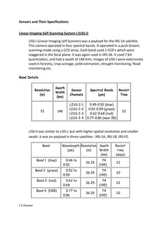
  • 1. Sensors and Their Specifications Linear Imaging Self-Scanning System I (LISS-I) LISS-I (Linear Imaging self Scanner) was a payload for the IRS-1A satellite. This camera operated in four spectral bands. It operated in a push-broom scanning mode using a CCD array. Each band used 2 CCD's which were staggered in the focal plane. It was again used in IRS-1B. It used 7 bit quantization, and had a swath of 148 Kms. Images of LISS-I were extensively used in forestry, crop acreage, yeild estimation, drought monitoring, flood monitoring etc. Band Details Swath Resolution Sensor Spectral Bands Revisit Width (m) Channels (µm) Time (km) LISS-I-1 0.45-0.52 (blue) LISS-I-2 0.52-0.59 (green) 72 148 22 LISS-I-3 0.62-0.68 (red) LISS-I-4 0.77-0.86 (near IR) LISS-II was similar to LISS-I, but with higher spatial resolution and smaller swath. it was on payload in three satellites : IRS-1A, IRS-1B, IRS-P2. Band Wavelength Resolution Swath Revisit (µm) (m) Width time (km) (days) Band 1 (blue) 0.46 to 74 36.25 22 0.52 (145) Band 2 (green) 0.52 to 74 36.25 22 0.59 (145) Band 3 (red) 0.62 to 74 36.25 22 0.68 (145) Band 4 (NIR) 0.77 to 74 36.25 22 0.86 (145) S K Diwakar
  • 2. Sensors and Their Specifications LISS-III The LISS-III (Linear Imaging Self Scanning Sensor) sensor is an optical sensor working in four spectral bands (green, red, near infrared and short wave infrared). It covers a 141km-wide swath with a resolution of 23 meters in all spectral bands. Band Wavelength Resolution Swath Revisit time (µm) (m) Width (days) (km) Band 1 0.52 to 0.59 23.5 142 5 (VIS) Band 2 0.62 to 0.68 23.5 142 5 (VIS) Band 3 0.77 to 0.86 23.5 142 5 (NIR) Band 4 1.55 to 1.7 70.5 148 5 (SWIR) LISS-IV sensor LISS-IV can work either in panchromatic or in multispectral mode with the same bands as LISS-III (except SWIR). However, the resolution is much better (5.8 m). For Resourcesat-1, the swath width varies from 23.9 km in multispectral mode to 70.3 km in panchromatic mode. For Resourcesat-2, the multispectral swath is enhanced to 70 km. The linear array sensor can be steered up to 26 degrees across-track, enabling stereoscopic imaging. Mode Spectral band Resolution Number of Array Panchromatic 0.50 – 0.75 µm 58 x 5.8 m 3 Number of Mode Band Spectral band Resolution Array Multispectral 2 0.52 – 0.59 µm 5.8 x 5.8 m 3 0.62 – 0.68 µm 5.8 x 5.8 m 1 4 0.77 – 0.86 µm 5.8 x 5.8 m S K Diwakar