SlideShare uma empresa Scribd logo
1 de 8
Samantha King
Open Street Map
G.I.S II
In this assignment, I used OpenStreetMap to better understand GIS data types and
models. I located an area on OpenStreetMap that would benefit from editing such as that with
missing features, incorrect labels, and/or incorrect positioning. This assignment is a learning
experience and gave me some exposure to a real-world, multi-user GIS system that is entirely
different than ArcGIS. I have not used any other program other than ArcGIS so I was excited to
see what another program could offer.
I deliberated a lot about which area I wanted to choose because I felt that a lot of students
were going to chose areas very close to Glassboro. I wanted to choose an area that I was very
familiar with so I could look at a map and pick out things that are missing or wrong. I located
an area in which I have lived since I was a sophomore in high school which is Marmora, NJ. I
am very familiar with the surroundings and know nearby towns so this area appealed to me.
Looking at the map I found that improvement could be made on the area that I chose. A lot of
construction had been done and new buildings were put up that were not updated in OSM. The
map below is on OpenStreetMap snapshot of the area that I am focusing on and it was really
interesting to see what the area looked like with a lot of the editing missing. This is the
downtown area that I focused on.
After adding a lot of points and areas that were missing, my map came to look like this for the
area right over the 34th street Bridge from Ocean City. (It is a lot more detailed)
The next map that I have is from Walking Papers and it is what I referred to when I first looked
at the area of Marmora. I focused right off the bridge near the parkway and when tourists first
come into the area. I zoomed into downtown where a lot of construction was done and editing
was needed so I was excited to do so.
This is an area that is right off of Roosevelt Blvd. and when you turn left at the light onto Route
9 South, I found that a lot of the places were not labeled or updated. Below is an area in which I
labeled a construction area where there is now a Shop Rite and other shops/restaurants.
I also noticed that some roads were not edited to be a cul-de-sac in my neighborhood so I took
care of them (denoted by small black dots); and I also noticed that was a body of water denoted
by a small blue box that was not there before.
I then looked down Stagecoach Road below and saw that Caldwell Park needed some updating
and so I added the whole area and added a picnic site along with toilets and water fountains. The
area is now larger and it looks better updated.
The next area that was in dire need of an update was Whipporwhill Campground. This area was
not updated at all. I added the entire campsite along with the RV docks for tourists and people
that actually live there. I also added the campsite amenities and paths that were missing. I added
the parks/recreation and bathrooms that were missing as well. My house is within walking
distance of this area so it was easy for me to record. The image below is what I updated.
Going to the other side of town, I noticed that the schools were labeled in the wrong spot. I
moved the Upper Township Primary School to where it should be. Shown below you can see
where the before and after shots are.
Before
After: I also added the correct recreation area for the schools.
In the next area I looked at, I saw that no one had updated some small things on North Shore Rd.
There is no golf course anymore (it is replaced with a residential neighborhood) and I also added
some cal-de-sacs. Here are some before and after pictures.
Before
After:
In the area a little more North and near the water, I noticed a lot of items were missing due to
construction. I added the marina that was redone, parking, a coastline and some other small
things that are depicted below.
There is also a huge residential area that was redone and is right on the water.
As I started following the map down to the connecting cities of Somers Point and the lower parts
of Ocean City, I noticed a whole lot of construction and buildings had not been updated. I just
wanted to focus on my town of Marmora, NJ; however if there are more users who are looking to
update an area, they can start with the 9th street bridge coming out of Ocean City.
I really enjoyed this assignment as it gave me a ‘hands on’ opportunity to really see how my
town has developed over the years and how maps need updating. I found it fun to see how many
things needed to be added and changed to make the area more up to date. Marmora is not a large
town and I made a lot of updates and changes that will help users who look at the map.

Mais conteúdo relacionado

Mais de Samantha King

Mais de Samantha King (9)

ScoreReport
ScoreReportScoreReport
ScoreReport
 
Map Example 2
Map Example 2Map Example 2
Map Example 2
 
Example Map
Example MapExample Map
Example Map
 
gis2finalpaper
gis2finalpapergis2finalpaper
gis2finalpaper
 
Ideasforreading
IdeasforreadingIdeasforreading
Ideasforreading
 
IEP Review Assignment
IEP Review AssignmentIEP Review Assignment
IEP Review Assignment
 
Six discussions
Six discussionsSix discussions
Six discussions
 
Connor PIA
Connor PIAConnor PIA
Connor PIA
 
Swimming Pic
Swimming PicSwimming Pic
Swimming Pic
 

openstreetmap

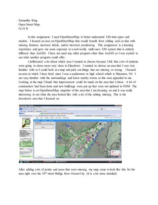
  • 1. Samantha King Open Street Map G.I.S II In this assignment, I used OpenStreetMap to better understand GIS data types and models. I located an area on OpenStreetMap that would benefit from editing such as that with missing features, incorrect labels, and/or incorrect positioning. This assignment is a learning experience and gave me some exposure to a real-world, multi-user GIS system that is entirely different than ArcGIS. I have not used any other program other than ArcGIS so I was excited to see what another program could offer. I deliberated a lot about which area I wanted to choose because I felt that a lot of students were going to chose areas very close to Glassboro. I wanted to choose an area that I was very familiar with so I could look at a map and pick out things that are missing or wrong. I located an area in which I have lived since I was a sophomore in high school which is Marmora, NJ. I am very familiar with the surroundings and know nearby towns so this area appealed to me. Looking at the map I found that improvement could be made on the area that I chose. A lot of construction had been done and new buildings were put up that were not updated in OSM. The map below is on OpenStreetMap snapshot of the area that I am focusing on and it was really interesting to see what the area looked like with a lot of the editing missing. This is the downtown area that I focused on. After adding a lot of points and areas that were missing, my map came to look like this for the area right over the 34th street Bridge from Ocean City. (It is a lot more detailed)
  • 2. The next map that I have is from Walking Papers and it is what I referred to when I first looked at the area of Marmora. I focused right off the bridge near the parkway and when tourists first come into the area. I zoomed into downtown where a lot of construction was done and editing was needed so I was excited to do so.
  • 3. This is an area that is right off of Roosevelt Blvd. and when you turn left at the light onto Route 9 South, I found that a lot of the places were not labeled or updated. Below is an area in which I labeled a construction area where there is now a Shop Rite and other shops/restaurants. I also noticed that some roads were not edited to be a cul-de-sac in my neighborhood so I took care of them (denoted by small black dots); and I also noticed that was a body of water denoted by a small blue box that was not there before.
  • 4. I then looked down Stagecoach Road below and saw that Caldwell Park needed some updating and so I added the whole area and added a picnic site along with toilets and water fountains. The area is now larger and it looks better updated. The next area that was in dire need of an update was Whipporwhill Campground. This area was not updated at all. I added the entire campsite along with the RV docks for tourists and people that actually live there. I also added the campsite amenities and paths that were missing. I added the parks/recreation and bathrooms that were missing as well. My house is within walking distance of this area so it was easy for me to record. The image below is what I updated.
  • 5. Going to the other side of town, I noticed that the schools were labeled in the wrong spot. I moved the Upper Township Primary School to where it should be. Shown below you can see where the before and after shots are. Before After: I also added the correct recreation area for the schools.
  • 6. In the next area I looked at, I saw that no one had updated some small things on North Shore Rd. There is no golf course anymore (it is replaced with a residential neighborhood) and I also added some cal-de-sacs. Here are some before and after pictures. Before
  • 7. After: In the area a little more North and near the water, I noticed a lot of items were missing due to construction. I added the marina that was redone, parking, a coastline and some other small things that are depicted below.
  • 8. There is also a huge residential area that was redone and is right on the water. As I started following the map down to the connecting cities of Somers Point and the lower parts of Ocean City, I noticed a whole lot of construction and buildings had not been updated. I just wanted to focus on my town of Marmora, NJ; however if there are more users who are looking to update an area, they can start with the 9th street bridge coming out of Ocean City. I really enjoyed this assignment as it gave me a ‘hands on’ opportunity to really see how my town has developed over the years and how maps need updating. I found it fun to see how many things needed to be added and changed to make the area more up to date. Marmora is not a large town and I made a lot of updates and changes that will help users who look at the map.