
Recommended
Recommended
More Related Content
Viewers also liked
Viewers also liked (20)
Similar to การจ ดการมาตราส วนแผนท__ map scale management
Similar to การจ ดการมาตราส วนแผนท__ map scale management (20)
Recently uploaded
Recently uploaded (20)
การจ ดการมาตราส วนแผนท__ map scale management
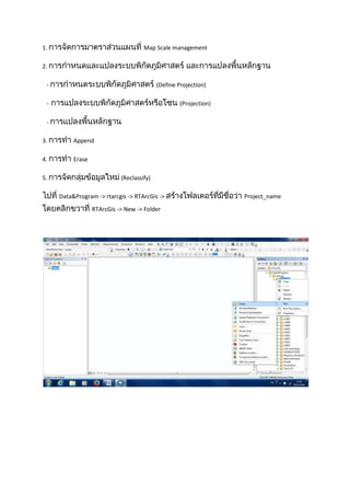
- 1. 1. Map Scale management 2. - (Define Projection) - (Projection) 3. Append 4. Erase 5. (Reclassify) Data&Program -> rtarcgis -> RTArcGis -> RTArcGis -> New -> Folder Project_name
- 2. Copy Lab 11 View -> Data Frame Properties Chaopaya General Project_name Units Meters OK
- 4. Chaopaya -> Properties -> Layer Properties -> Source OK Project Toolboxes -> System Toolboxes -> Data Menagement Tools -> Projection and Transformations -> Define Projection
- 5. Input Dataset or Feature Class Chaopaya -> Coordinate System Select -> Projected Coordinate Systems -> UTM ->WGS1984 -> Northern Hemisphere -> WGS1984UTMZone47N.prj -> OK Projection ( Blank Map -> OK ) New Map File New Document
- 6. LAB 11 -> World -> Country Display Area ArcToolbox -> Data Management Tools ->Feature -> Project ( )
- 7. Project Coordinate System WGS_1984 -> Output Coordinate System > Close Input Dataset Output Dataset country -> Input Project_name -> WGS_1984_UTM_Zone_47N -> Country_UTM -> OK -
- 8. (Maps Scale Management) - (Define Projection) - (Project) Lab 11 -> World -> Province _WGS84UTM47N Bangkok_Indian1975UTM47N Zoom IN -> Display Area Display Area Bangkok_Indian1975UTM47N
- 9. Bangkok_Indian1975UTM47N Frame Properties -> Coordinate System -> Province_WGS84UTM47N ,Z 295 New ( View -> Data -> Select a coordinate System -> Layers -> Transformations GCS_WGS_1984 GCS_WGS_1984 WGS 1984 Convert from Into Parameters -> X 206 GCS_Indian_1975 ,Y 837
- 10. X = 206 Append -206 ) -> OK -> OK -> OK
- 11. Lab 12 -> Data -> Copy ->Lu5038i , Lu5138iv Project_name Display Area ArcToolbox Data Management Tools -> General -> Append
- 12. Append -> NO_TEST -> Target Dataset Input Lu5138iv -> Schema Type Lu5038i -> OK Erase Lab 12 -> Pathum Thani -> WATER SOILS, WATER Zoom In
- 13. ArcToolbox -> Analysis Tools -> Overlay -> Erase Input Feature SOILS -> Output Feature Class Erase Erase Feature Project_name (Reclassify) WATER -> Erase -> Save -> OK
- 14. RTArcGIS -> Prachinburi -> Prachindem 30 m Display Area ArcToolbox -> 3D Analysis Tools -> Raster Reclass -> Reclassify Reclassify
- 15. Input raster Reclassification ( Prachindem 30 m.tif -> Classify -> Reclass field Method ->Manual )-> OK -> OK value ->
- 16. Reclass_tif1 -> Properties -> Symbology -> Add All Values -> OK