

Recomendados
Mais conteúdo relacionado
Mais procurados
Mais procurados (20)
Semelhante a Ilf euregeo 2012 poster 1
Semelhante a Ilf euregeo 2012 poster 1 (20)
Mais de Ricardo Brasil
Mais de Ricardo Brasil (17)
Último
Último (20)
Ilf euregeo 2012 poster 1
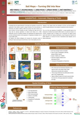
- 1. Soil Maps – Turning Old into New INÊS FONSECA (1); RICARDO BRASIL (1); JORGE ROCHA (1); SÉRGIO FREIRE (2); JOSÉ TENEDÓRIO (2) (1) RISKam, Centre for Geographical Studies, Institute of Geography and Spatial Planning - University of Lisbon, Edf. Fac. Letras, Universidade de Lisboa, Alameda da Universidade, 1600-214 Lisbon, Portugal. i.fonseca@campus.ul.pt (2) Centro de Estudos de Geografia e Planeamento Regional, Faculdade de Ciências Sociais e Humanas da Universidade Nova de Lisboa, Av. De Berna 26-C, 1069-061 Lisbon, Portugal ResearchGrouponEnvironmentalHazardandRiskAssessmentandManagement CentreforGeographicalStudies InstituteofGeographyandSpatialPlanning,UniversityofLisbon www.riskam.org AutoMAPticS – Automatic Mapping of Soils Introduction Knowledge about the spatial distribution of soil types and properties is crucial for the assessment of their ability to support a range of services, from food production, to biodiversity and pollution buffering. Whilst soil surveys have been carried out in many countries, the area coverage and scale of resulting soil maps are far from being ideal for planning applications at national level (Dobos et al., 2006). Additionally, the lack of consistency between soil classifications and legends across countries contributes towards a slow progression in integrating soil datasets, even in Europe (ESBN, 2005). GIS together with artificial intelligence (AI) maximize the information content of existing soil maps by learning the rules that have, more or less explicitly, led to the mapping of soil classes across the landscape, and then use that knowledge to predict the spatial distribution of soil classes or properties at similar resolutions. Thus, one of the main objectives of AutoMAPticS , a project partiallly based on the development of artificial neural network (ANN) models, is to predict soil classes in (i) currently unmapped areas of Portugal, and (ii) harmonise soil legends across regions with distinct soil mapping classifications, using Portuguese and Spanish soil spatial datasets to a) improve the level of transnational data integration and b) assess existing data. Data Constraints Soil map coverage remains incomplete There is a lack of cartographic uniformity between different regions: Scales (1:50000 and 1:100000) Taxonomic Systems (National and International (FAO)) Framework (Physiographic vs Taxonomic) Data Advantages 43% of the area has international standards of soil maps for which a very large number of geo- referenced soil samples were collected There are geo-referenced soil profile data at several sites in the unmapped areas Maps at different scales for the same areas provides the means for a thorough assessment of predicted soil maps Existing Soil Maps Spatial Modelling of Soils Predicted soil types and properties at new locations Artificial Intelligence Geographic Information Systems Old Soil Maps Issues Addressed Input Data Resolution Types of ANN models ANN model parameters Global vs Local ANNs Training Areas Geographical Transferability Fuzziness Existing Soil Maps Digital Elevation Data & derived parameters Lithological Data Land Use Cover New Soil Map Artificial Neural Network References DOBOS E., CARRÉ F., HENGL T., REUTER H.I. & TÓTH G. (2006) Digital Soil Mapping as a Support to Production of Functional Maps. EUR 22123 EN. Office for Official Publications of the European Communities, Luxemburg, 68pp. ESBN (EUROPEAN SOIL BUREAU NETWORK) (2005) Soil Atlas of Europe. European Commission, Office for Official Publications of the European Communities, L-2995 Luxemburg, 128pp.