Recomendados

Recomendados
Mais conteúdo relacionado
Mais procurados
Mais procurados (20)
Destaque
Destaque (9)
Semelhante a GSA POSTER FINAL
Semelhante a GSA POSTER FINAL (20)
GSA POSTER FINAL
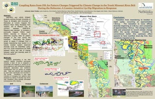
- 1. Coupling Rates from OSL for Pattern Changes Triggered by Climate Change in the Trunk Missouri River Belt During the Holocene: A Counter-Intuitive Up-Dip Migration in Response Abstract: NSF/REU and USGS EDMAP students working through University of Texas at Arlington and University of Nebraska at Lincoln mapped the Missouri River Valley floodplain from Yankton, SD to Missouri City, IA (237km) between 2008-2010. Mapping was intended to compare a previously mapped 100km reach 500km downdip in Missouri to determine coupling rates for pattern changes in the river during the Holocene. Particularly, the project aimed to asses if changes from a largely meandering loop system to a heavily braided system observed downdip could be indentified updip, and if so, could comparisons be made between timing and rate of change between updip and downdip parts of the trunk system? Methods: Students participating in the field research applied consistent techniques whereby a team of two is assigned a quadrangle and mapping is carried out by hand augering to test consistently between lithofacies association and landforms hypothesized from air photos at multiple sites. Data are collected and interpreted by each team individually and recorded in GIS format. Transitions in loop style indicative of changing river patterns were assessed by dating of discrete loop forms near transitions using optically stimulated luminescence (OSL) testing. Author(s): Adam Trimble, Justin Anderson, Chris Hendrix, Rachel Albertson, Diana Flores, David Grasman, Jenna Newman, Vince Egyed, John Patten, Shane Patterson, Michele Kashouh, Dan Carlin & Dr John Holbrook. AKA The Mud Rangers Conclusion: Transition from meandering to braided is rapid updip, occurring at approximately 1.5k.b.p. The transition is more diffuse downdip beginning at 3.5k.b.p. and completing at approximately 1.5k.b.p. The change is basin- wide and presumed to record climate change within the up-dip drainage. Counter to conventional belief, this upstream effect appears to have manifest down-dip first, then complexly migrated up dip. Acknowledgments/References: The 2010 Mud Rangers would like to thank The University of Texas at Arlington’s Dr John Holbrook, The University of Nebraska at Lincoln’s Dr Ron Goble; The National Science Foundation and the USGS as well as the Lewis and Clark Anthropology Group and Google Maps for materials used. We would also like to thank every group of Mud Rangers that paved the way down the Missouri River in previous years. Drill Analyze Collaborate 2010 Mud Ranger Mapping Area Missouri River Basin 0.67ka 1.78ka 1.01ka 6.59ka 7.29ka 6.59ka 0.68ka 1.56ka 4.68ka Transitional Morphology 4a 3.4+/-.1kbp – 1.3+/-.1kbp Meandering Morphology 3 4.4kbp+ - 3.4+/-.1kbp Braided Morphology 4a -4b 3.0 – 1.2 +/-.1kbp Transition Braided Morphology Meandering Morphology Meandering Morphology Braided Morphology 3.49ka 0.46ka 11.2ka 14ka 1.53ka 0.95ka 10.2ka 16.8ka 0.95ka OSL Dates from Point-bars of Meander Loops Morphology 1 Morphology 2 Morphology 3 Morphology 4bMorphology 4a 0.59ka