1. !
!
!
!
!
!
!
!
!
!
!!
!
!
!
!
! !
!
!
!
!
!
!
!
!
!
! !
!
!
!
!
!
!
!
!
!
!
!
!
!
!
!!
!
!
!
!
!
!
!
!
!
!
!
!
!
!
!
!
!!
!
!
!
!!
!
!
!
!
!
!
!
! !
!
!
!
!
!
!
!
!
!
!
!
!
!
!
!
!
!
!
!
!
!
!
!
!
!
! !
!
!
!
!
!
!
!!
!
!
!
!
!
!
!
!
!
!
!
!
!
!
!
!
!
!
!
!
!
!
!
!
!
!
! !
!
!
!
!
!
!
!
!
!
!
!
!
!
!
!
! !
!
!
!!
!
!
!
!
!
!
!
!
!
!
!
!
!
!
!
!
!
!
!
!
!
!
!
!
!
!
!
!
!
!
!
!
!
!
!!
!
!
! !
!
!
!
!
!
!
!
!
!
!
!
!
!
!
!
!
!
! !
!!
!
!
!
!
!
!
!
!
!
!
!
!
!
!
!
!
!
!
!
!
!
!
!
!
!
!
!
!
!
!
!
! !
!
!
!
!
!
!
!
!
!
!
!
!
!
!
!
!
!
!
!
!
!
!
!
!
!
!
!
!
!
!
!
!
!
!
!
!
!
!
!
!
!
!
!
!
!
!
!
!
!!
!
!
!
!
!
!
!
!
!
!
!
!
!
!
!
!
!
!
!
!
!
!
!
!
!
!
!
!
E
E
E
E
E
E
E
E
E
E
E
EE
E
E
E
E
E E
E
E
E
E
E
E
E
E
E
E
E
E
E
E
E
E
EE
E
E
E
E
E
E
E
E
E
E
EE
E
E
E
E
E
E
E
E
E
E
E
EE
E
E
E E
E
E
E
E
E
E
E
E
E
E
E
E
E
E
EE
E
E
E
E
E
E
E
E
E
E
E
E
E
E
E
E
E
E
E
E
E
E
EE
E
E
E
E
E
E
E
EE
E
E
E
E
E
E
E
E
E
E
E
E
E
E
E E
E
E
E
E
E
E
E
E
E
E
E
EE
E
E
E
E
EE
E
E
E
E
E
E
EE
E
E E
E
E
EE
E
E
E
E
E
E
E
E E
E
E
E
E
E
E
E
E
E
E
E
E
E
E
E
E
E
E
E
E
E
E
E
E
E
E E
E
E
E
E
E
E
E
E
E
E
E
E
E
E
E
E
E
E
E
E
E
E
E
E
E
E
E
E
E
E
E
E
E
E
E
E
E
E
E E
E
E
E
E
E
E
E
E
E
E
E
E
E
E
E
E
E
E
E
E
E
E
E
E
E
E
E
E
E
E
E
E
E
EE
E
E
E
E E
E
E
EE
E
E
E
E
E
E
E
E
E
EE
E
E
EE
E
E
E
E
E
E
E E
E
E
E
E
E
E
E
E
E
E
E
E
E
E E
E
E
E
E
E
E
E
E
E
E
E
E
E
E
E
E
E
E
E
E E
E
E
EE
E
E
E
E
E
E
E
E
E
E
E
E
E
E
E
E
E
E
E
E
E
E
E
E
E
E
E
E
E
E
E
E
E
E
EE
E
E
E E
E
E
E
E
E
E
E
E
E
E
E
E
E
E
E
E
E
E
E
E E
EE
E
E
E
E
E
E
E
E
EE
E
E
E
E
E
E
E
E
E
E
E
E
E
E
E
E
E
E
E
E
E
E
E
E E
E
E
E
E
E
E
E
E
E
E
E
E
E
E
E
E
E
E
E
E
E
E
E
E
E
E
E
E
E
E
E
E
E
E
E
E
E
E E EE
E E
E E
E
E
E
E
E
E
E
E
E
E
E
E
E
E
E
E
E
E
E
E
E
E
E
E
E
E
E
E
E
E
E
E
E
E
E
E
E
E
E
E
E
E
E
E
E
E
E
E
E
E
E
E
E
E
E
E
E
E
E
E
E
EE
E E
E
E
E
E
E
E
E
E
E
E
E
E
E
E
E
E
E
E
E
E
E
E
E
E
E
E
E
E
E E
E
E
E
E
EE
E
E
E
E
E
E
E
E
E
E
E
E
E
E
E
E
E
E
E
E
E
E
E
E
E
E
E
E
EE
E
E
E
E
E
E
E
E
E
E
E
E
E
E
E
E
E
E
E
EE
E
E
E
E
E
E
E
E
E
E
E
E
E
EE
EE
E
E E
E
E
E
E
E
E
EE
E
E
E
E
E
E
E
EE
E
E
EE
E
EE
E
E
EE
E
E
E
E
E
E
E
E EE
EE E
E
E
E
E
E
E
E E
E
EE
E
EE
E
EE
E
EE E E
E
E
EEE
EE
E
E
E
E
E
E
E
E
E
E
E E
EE
EE
E
EE
E
E
E
E
E
E
EE
E
E
E E
E
E
E
E
EE E
E E
E
E
E
E E
E
E
E
E
E
E
E
E
E
E
E
E
E E
E
EE
EE
E
E
E
E
E
E
E
E
E
E
E
E
E
E
E
E
E
E
E
E
E
EE
E
E
E
E
E
E
E
E
E
E
E
E
E
E
E
E
E
E
E
E
E
E
E
E
E
E
E
E
E
E
EEEE
EE
E
E
E
E
E
E
E
E
E
E
E
E
E
E
EE E E
E
E
E
E
E
E
E
E
E
EEE
E
EE
E
E E
E
E
E
E
E
E
E
E
E
E
E E
E
E
EE
E
E
E
E
E
E
E
E
E
E
E
E
E
EE
E
E
E
E
E
E
E
E
E
E
E
E
E
E
E
E
EE
E
E
E E
EE
EE
E
E
E
E
E
E
E
E
E
E
E
E
E
E
E
E
E
EE
E
E
EEE
EE
E
E
EE
E
E
E
E
E
E
E
E
E E
E
E
E
E
E
E
E
E
E
E
E
EE
EEE
E
E
E
E
E
E
E
E
E
E
E
E
E
E
E
E
EE
E
E
E E
E
E
E
E
E
EE
EE
E
E
E
E E
E
E
E
E
EE
E
EE
E
E
E
North to
Sacramento
East to
San Andreas
East to
San Andreas
East to
Angels Camp
East to
Oakdale
South to
Modesto
Sims
Station
Henderson
Village
Farmington
Coopers
Corner
Acampo
STANISLAUSCOUNTY
Glenwood
Victor
Turner
Five
Corners
Peters
Dog
Town
Clements
MantecaManteca
StocktonStockton
LodiLodi
WoodbridgeWoodbridge
LockefordLockeford
LindenLinden
MoradaMorada
EscalonEscalon
Collierville
SACRAMENTO COUNTY
Waterloo
Noble Acres
Collegeville
Mossdale
RiponRipon
LathropLathrop
CALAVERASCOUNTY
FrenchFrench
CampCamp
4
-3
-7
-6
-9
-9
-2
-8
-6
-8
-4
-6
-5
-4
-3
-8
-8
-2
-6
-9
-9
-8
-9
-9
-9
-9
0.5
-13
-14
-11
-10
-11
-16
-14
-15
-11
-29
-20
3.8
-16
-28
-14
-12
-16
3.6
3.1
-14
-15
-10
-14
-13
-11
-11
-12
-15
9.3
-16
2.7
-275.8
-6.6
-4.5
-3.2
-7.6
-9.5
-7.8
-1.6
-0.2
-0.7
-2.2
-0.6
-4.1
-2.1
-9.2
-4.2
-3.7
-5.9
-2.7
-2.6
-5.6
-6.6
-5.2
-7.7
-6.5
-6.4 -5.9
-7.5
-3.5
-4.7
-5.6
-8.2
-1.8
-9.8
-6.1
-8.7 -6.8
-9.3
-8.6
-8.3
-6.9
-9.9
-6.6
-7.6
-9.5
-7.8
-4.4
-2.8
-6.7
-9.2
-7.2
-3.6
-5.8
-7.9
-7.4
-9.5
-1.8
-8.8
-7.3
-4.2
-6.5
-6.5-7.7
-8.8
-8.5
-9.4
-8.2
-5.2
-6.1
-9.9
-2.8
-2.2
-9.8
-5.8
-1.5
-8.5
-6.9
-9.2
-5.5
-9.7
-9.2
-7.9
-2.7
-0.6
-3.9
-3.1
-6.2
-9.6
-7.3
-8.5
-6.9
-6.7
-7.6
-5.6
-6.3
-9.4
-8.4
-6.7
-5.4
-5.1
-3.1
-3.3
-8.7
-9.8
-9.5
-9.8
-8.3
-6.7
-4.4
-7.1-8.6
-9.2
-5.2
-3.7
-0.3
-3.1
-2.4
-3.6
-7.3
-5.7
-9.1
-6.5
-8.7
-7.5
-6.5
-5.9
-8.8
-9.5
-9.1
-9.2
-8.4
-9.7
-7.6
-6.5
-9.2
-9.5
-9.1
-9.4
-4.1
-5.9
-7.7
-8.7
-7.3
-5.9
-8.4
-7.9
-7.6
-6.5
-2.1
-6.6
-5.2
-8.4
-7.1
-9.5
-8.2
-0.7
-8.1
-9.7
-3.6
-8.5
-3.2
-4.4
-3.7
-3.7
-5.8
-1.7
-0.8 -6.5
-5.6
-8.5
-8.9
-4.7
-8.6
-8.2
-6.8
-8.5
-5.8
-0.8
-7.5
-7.7
-6.7
-4.6
-3.9
-11.2
-13.9
-11.6
-10.2
-10.8
-3.85 -11.9
-12.8
-10.4
-16.7
-13.6
-10.2
-11.3
-11.5
-12.4
-10.4
-17.7
-10.5
-13.2
-12.5
-15.3
-12.6
-12.7
-14.1
-12.7
-10.3
-13.2
-12.6
-12.5
-13.1
-10.9
-10.6
-12.7
-31.2
-3.95
-17.4
-40.5
-10.5
-13.4-11.9
-12.7
-13.5
-16.9
-17.4
-14.4
-28.2
-12.3
-25.5
-17.7
-10.5
-12.6
-11.3
-11.4
-13.5
-15.2
-10.3
-10.8-10.4
-10.6
-11.5
-12.9
-11.8
-12.5
-11.6
-11.3
-13.2
-10.4
-10.1
-12.1
-11.7
-17.2
-14.8
-21.7
-12.3
-24.2
-17.1-11.4
-10.7
-10.7
-13.8
-10.5
-17.8
-17.6
-13.6
-23.6
-10.35
-13.25
-10.55
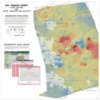
SAN JOAQUIN COUNTY
GROUNDWATER DATA CENTER
The San Joaquin County Groundwater Data Center (GDC) is a Countywide centralized groundwater
information vehicle that provides access to groundwater data collected and shared by agencies
throughout San Joaquin County. Over the internet, water interests including groundwater users,
Basin stakeholders, industry professionals, decision makers, and the general public will be able
to access historic groundwater data.
FLOOD CONTROL
AND
WATER CONSERVATION DISTRICT
> -20 ft. Decrease
-18 to -20
-16 to -18
-14 to -16
-12 to -14
-10 to -14
-8 to -10
-6 to -8
-4 to -6
-2 to -4
0 to -2
> 0 ft. Increase
CHANGES IN DEPTH TO WATER MEASUREMENTS
FROM FALL 2011 TO FALL 2014
!E Well Locations Containing
Measurements from Both
2011 and 2014
GROUNDWATER MONITORING
Since the Fall of 1971, the San Joaquin County Flood Control and Water Conservation District
has monitored groundwater levels and groundwater quality throughout San Joaquin County and has
published the data in the Semi-annual Groundwater Report. This report utilizes data from
Federal, State and local government agencies as well as non-governmental sources.
Water level data is collected on a semi-annual basis, during the months of April and October
to observe groundwater levels before and after peak groundwater pumping conditions. Over 550
wells, of which 300 are measured by County staff, are included in the Monitoring Program.
The exact number of wells varies from year to year, depending on circumstances such as
destructions, new well construction, well accessibility, and well condition.
This map represents the change in well depth to water measurements from Fall 2011 to Fall 2014.
The raster surface was created from the depth to water measurements using an inverse distance
weighted (IDW) technique using ESRI's ArcGIS Desktop software (ArcMap + 3D Analyst).
E Well Locations
1:72,000
0 1 2 3 40.5
Miles
E
www.sjmap.org/groundwater
§¨¦5
§¨¦5
·|}þ9 9
·|}þ9 9
·|}þ4
·|}þ4
·|}þ1 2
·|}þ120
·|}þ2 6
·|}þ4
San
Joaquin
County
STANISLAUS COUNTY
·|}þ8 8
·|}þ1 2
Printed 5/6/2015 NM