SlideShare uma empresa Scribd logo
1 de 8
Baixar para ler offline
Reflections Summer/Fall 2013
Visitor Guide
Watch the New
Park Film
A new, 22-minute film has just arrived at
the Steel Visitor Center—the park’s first new
orientation film since the 1980s! Covering
a variety of topics, the film explores the
significance of Crater Lake and the wonder
it has inspired for generations. The film is
called “Crater Lake: Into the Deep” and
includes dramatic underwater footage
as well as state-of-the-art animation that
depicts the park’s violent geologic past.
The film is shown daily on the hour and
half-hour from 9:00 a.m. to 4:30 p.m.
The auditorium in the Steel Visitor Center
is small, so watching the film in the early
morning or late afternoon is recommended
to avoid crowded conditions. Production
of the film was funded entirely by entrance
fees paid by park visitors like you. By
visiting the park, you are contributing to
future improvements. Thanks for your
support!
Plus 10 Other Ways to Enjoy Your Park
Watching the sun rise (or set) over Crater Lake can be
an unforgettable experience. With clean air, clear skies,
and unobstructed views, the park is usually a fantastic
place to observe the sun’s daily rituals, as well as other
celestial events. In fact, for many travelers, spending
dawn or dusk on the rim of Crater Lake is a highlight
of their visit. Opinions differ, though, as to the best
vantage points. At dawn, some people head to Discov-
ery Point or Watchman Overlook, both along the West
Rim Drive. From these locations (and from the top
of Watchman Peak, where the photo on the right was
taken), the waters of the lake sometimes glow in shades
of orange, pink, and purple.
As soon as the sun breaks the horizon, however, seeing the lake from these spots means staring
into the light, and opportunities for photographs diminish. That’s why many people prefer to
station themselves at sunrise along the East Rim Drive (or hike to the summit of Mount Scott,
where the photo at top was taken), so as to have the sun at their back when viewing the lake.
That’s also why, at sunset, most rangers recommend driving to Watchman Overlook or joining
a ranger-led hike to the top of Watchman Peak (see page 3), where you’ll catch the last rays of
light on the lake’s surface then watch the sun descend over a dozen mountain ridges between
the park and the Pacific Ocean. In the meantime, here are 10 other tips for making your visit to
Crater Lake more meaningful, memorable, and fun:
When is the Park Open?
Crater Lake National Park is open year-round, 24 hours
a day. Some roads, trails, and facilities, however, are
closed seasonally due to snow. Much of the year, the
park’s North Entrance Road and Rim Drive are closed
to cars. They close for the season on November 1 (or
earlier if there is significant snowfall).
Crews begin plowing these roads in April, but opening
dates vary. The North Entrance Road and West Rim
Drive tend to open in early June. The East Rim Drive
typically opens in early July. Highway 62 is open year-
round. The road to Rim Village is also open year-round,
except after heavy snowstorms.
National Park Service
U.S. Department of the Interior
Crater Lake
Welcome!
Thank you for visiting your national park.
Here at Crater Lake, you’ll find opportunities
to refresh your spirit, awaken your senses,
and connect with the natural world. This
year, you may notice that budget reductions
are having some effects on available services
and facilities. Please know that we are work-
ing hard to ensure that every dollar we do
have is used in the most efficient manner to
protect the park and provide you with the
best experience possible.
The National Park Service protects more
than 400 special places, saved by the
American people so that everyone can
experience our heritage. We at Crater Lake
are proud to be stewards of this national
treasure. Park rangers and maintenance
staff are here to assist you in making your
visit safe, rewarding, and fun. If there is
anything we can do to help, please ask.
Enjoy your park!
Craig Ackerman
Superintendent
Drive Around the Lake
Rim Drive is a 33-mile (53-km) road that
encircles Crater Lake. More than 30 pullouts
offer dramatic views of the park’s volcanic
scenery. Allow 2 to 3 hours (see page 5).
Hike a Trail
From easy walks to challenging hikes, the
park has something for everyone. Explore
pristine forests, flower-filled meadows, and
rocky peaks (see page 4).
Attend a Ranger Program
Discover the wonders of Crater Lake with
those who know the park best. Talks, walks,
kids programs, boat tours, and trolley tours
are offered daily (see page 3).
Find the Phantom Ship
Anchored near the lake’s south shore is an
island that seems to be sailing away. To see it,
hike to Sun Notch or drive to the viewpoint
named in its honor (see page 5).
Visit the Pinnacles
Formed during the same eruption that gave
birth to the lake, these colorful volcanic
spires are tucked away in the park’s
southeast corner (see page 5).
Tour Crater Lake Lodge
For a glimpse into an earlier era, check out the
history exhibits—and walk through the Great
Hall—of Crater Lake Lodge, renovated in the
1990s but first opened in 1915 (see page 2).
Visit the Sinnott Memorial Overlook
With panoramic views and fascinating
exhibits, this is the place to learn about the
park’s geologic story and history of scientific
investigation (see page 2).
Have a Picnic
The viewpoints and picnic areas along
Rim Drive are perfect for outdoor eating
(see page 5). Stop by the Rim Village Café for
grab-and-go sandwiches, salads, and snacks.
Relax
Find a peaceful spot and attune yourself to
the sounds and rhythms of the park. The
Lodge veranda and the quiet pullouts on the
lake’s north side are favorite spots to unwind.
Touch the Water
The trail to the lake shore is steep, dusty, and
often crowded, but the water at the bottom
is some of the world’s purest. Swim, fish, or
simply dangle your toes (see page 3).
Snow plow
at Rim Village
Park Profile
Crater Lake National Park protects the
deepest lake in the United States. Fed by
rain and snow (but no rivers or streams),
the lake is considered to be the cleanest
large body of water in the world. The
water is exceptional for its clarity and
intense blue color.
The lake rests inside a caldera formed
approximately 7,700 years ago when a
12,000-foot-tall (3,600-meter) volcano
collapsed following a major eruption. The
eruption may have been the largest in
North America in the past 640,000 years.
Later eruptions formed Wizard Island, a
cinder cone near the southwest shore.
Today, old-growth forests and open
meadows blanket the volcano’s outer
slopes, harboring a variety of plants and
animals, including several rare species.
The area is central to the cultural traditions
of local American Indian tribes, and the
park provides unique opportunities for
scientific study and public enjoyment.
• Park established: 1902
•	 Size: 183,000 acres (74,060 hectares)
•	 Visitors per year: About 500,000
•	 Lake depth: 1,943 feet (592 meters)
•	 Lake width: 4.5 to 6 miles (7 to 10 km)
•	 Annual snowfall: 43.5 feet (13.2 meters)
•	 Last time the lake froze over: 1949
Artist Paul Rockwood’s conception of
Mount Mazama, the volcano that collapsed
to form Crater Lake. If you gathered up the
ash from Mount Mazama’s catastrophic
eruption and spread it evenly across the
state of Oregon, it would form a layer
8 inches (20 cm) thick.
2
3
4
5
6
7
8
Look Inside! 
... Camping, Lodging, Food
... Ranger Programs
... Hiking Trails
... Driving Map
... In the News: Rim Road
... In the News: Lidar, Foxes
... Climate Chart
Catch a Rising Star
Crater Lake National Park belongs
to everyone. We all share respon-
sibility in protecting it. Please take
a moment to become familiar
with these important regulations.
For a full list of the park’s rules,
visit www.nps.gov/crla/parkmgmt/
lawsandpolicies.htm.
Camping
Camping is limited to developed
campgrounds and some backcountry
areas. Permits are required for
backcountry camping (see page 3).
Driving
Use pullouts to enjoy the views.
Do not stop in the road. Observe
posted speed limits, and watch for
wildlife, bicyclists, and pedestrians.
Off-road travel is prohibited.
Fires
Fires are allowed only in designated
rings in the Rim Village Picnic Area
and campgrounds. Fires may be re-
stricted at certain times; ask a ranger.
Food
Store food properly. Generally, this
means sealed in your vehicle or a
campground food locker. Backcoun-
try campers should use bearproof
canisters or hang food from a tree.
Exposing wild animals to our food
alters their behavior, is bad for their
health, and can be dangerous for us.
Hiking and Climbing
Stay on trails. This prevents erosion,
protects vegetation, and protects
other hikers. Shortcutting trails is
prohibited. Hiking and climbing
inside the caldera are strictly
prohibited. The only exception is
the Cleetwood Cove Trail, the only
safe and legal access to the lake
shore. Serious injuries and deaths
have occurred from falls inside the
caldera. The walls consist of steep,
unstable rocks and soils.
Park Features	
Leave rocks, plants, animals, and
artifacts undisturbed for others to
enjoy. Collecting, defacing, destroy-
ing, or disturbing natural, cultural,
or historical features is prohibited.
Pets
Pets on a leash—or otherwise
physically restrained—are welcome
in the park, but only in developed
areas. They are allowed within 50
feet (15 meters) of roads, estab-
lished parking areas, developed
campgrounds, and designated
picnic areas. Pets are not allowed
inside buildings, including Crater
Lake Lodge and The Cabins at Maz-
ama Village. Pets are not allowed
on park trails or in the backcountry.
The presence of pets can confuse
and frighten wild animals, affecting
their behavior. The above rules do
not apply to service dogs here to
assist people with disabilities.
Good places to walk a dog include
Rim Village, Mazama Campground,
and Grayback Drive. Solid pet ex­
crement must be picked up imme-
diately by the owner or person in
control of the pet and disposed of
in a trash or solid-waste receptacle.
Viewpoints
Stay back from the rim of the
caldera. Do not go beyond
established fences and rock walls.
Falling may cause injury or death.
Weapons
Firearms are prohibited in all posted
park buildings.
Wildlife
Never feed wildlife. This includes
birds and squirrels. Feeding animals
is dangerous for you, bad for them,
and harmful to the ecosystem.
Feeding, touching, disturbing, or
approaching wildlife is prohibited.
Accessibility
Except for the Sinnott
Memorial Overlook,
developed areas in the
park are generally ac-
cessible to individuals
with mobility impair-
ments. Wheelchair-
accessible paths include
the Rim Village prom-
enade and the Pinnacles
Trail. The Godfrey Glen
Trail and Plaikni Falls
Trail are accessible to
wheelchair users with
assistance (see page 4).
Multiple pullouts on
Rim Drive have wheel-
chair-accessible wayside
exhibits. Some ranger
programs are accessible
to people with limited
mobility and other im-
pairments (see page 3).
We are working hard
to improve our level of
accessibility for all park
visitors. We welcome
your comments.
ATMs
The Mazama Village
Store and Rim Village
Gift Shop have ATMs.
Drinking Water
Water faucets can be
found at Rim Village,
Mazama Village, and
inside the Steel Visitor
Center. Bottled water
can be purchased at the
Rim Village Café, the
Mazama Village Store,
and the bottom of the
Cleetwood Cove Trail
(when boat tours are
operating).
Emergencies
Dial 911 to report any
emergency, 24 hours a
day. First aid is available
at visitor centers and
the ranger station at
Park Headquarters.
Entrance Fee
The entrance fee for
Crater Lake National
Park is $10 per family
car, good for 7 days.
The rate is higher for
commercial vehicles.
Your fees are put to
work improving visitor
services and facilities.
Thank you for support-
ing your national parks!
Gasoline
Self-serve gasoline is
available at Mazama
Village from May 24
through October 14.
Internet
Wireless internet is free
for guests of Crater Lake
Lodge and The Cabins
at Mazama Village. Pub-
lic Wi-Fi is available at
Crater Lake Lodge and
the Annie Creek Restau-
rant for $4 per hour or
$10 for 24 hours.
Lost & Found
Contact a ranger at
either visitor center or
call 541-594-3060.
Phones
Cell phone coverage in
the park is unreliable.
Reception depends
on your location and
provider. Pay phones
are located outside the
Mazama Village Store
and inside Crater Lake
Lodge.
Picnic Areas
Picnic areas are found
throughout the park
(see page 5). The Rim
Village picnic area has
fire grates. Most picnic
areas have vault toilets
but no running water.
Post Office
A U.S. Post Office is open
Monday through Satur-
day in the Steel Visitor
Center. Summer hours
are 9:00 a.m.–noon and
1:00–3:00 p.m.
Recycling
Combination trash/
recycling bins can be
found around the
park at more than 20
locations. Recycling
is currently limited to
aluminum cans and
plastic bottles. All bins
can accept both.
Restrooms
Restrooms with flush
toilets and running
water are located at
Rim Village, Mazama
Village, and the Steel
Visitor Center (9:00
a.m.–5:00 p.m.). Vault
toilets are located at
most picnic areas,
Watchman Overlook,
and both ends of the
Cleetwood Cove Trail
(see map on page 5).
Showers & Laundry
Coin-operated showers
and laundry machines
are available at Mazama
Campground.
Camping
The park has two campgrounds. Both sit in
forests south of the lake. Holders of an Amer-
ica the Beautiful Senior Pass or Access Pass
are entitled to a 50% discount.
Mazama Campground (212 sites) is located
7 miles south of Rim Village near Highway 62.
In 2013, it will be open from May 31 through
October 6, weather permitting. 75% of the
campsites for July, August, and September are
reservable in advance by calling 1-888-774-
2728 or online at www.craterlakelodges.com.
The rest are available on a first-come, first-
served basis. Typically, there are sites available
until late afternoon or early evening. The
campground offers tent sites ($21 per night)
as well as RV sites ($29). Some of the RV
sites have electric hookups ($35). There are
many pull-through sites; some can accom-
modate RVs as long as 50 feet (15 meters).
Each site has a picnic table, fire ring, and food
locker. Black bears are rarely seen, but camp-
ers are advised to store all food in their locker
or their vehicle. The campground has drink-
ing water, flush toilets, public showers, and
laundry facilities. A nearby general store sells
groceries, firewood, and gasoline. You can
contact the campground directly during the
summer at 541-594-2255 ext. 3610. Mazama
Campground is operated by the park’s
concessioner, Xanterra Parks & Resorts.
Unfortunately, Lost Creek Campground
(16 tent sites) will be closed in 2013 due to
budget cuts. Most years, it opens in early
July and closes in mid-October. It is located
on the spur road to the Pinnacles Overlook.
Registration ($10 per night) is self-service,
and reservations are not taken. It has drinking
water and flush toilets. Each site has a picnic
table, fire ring, and food locker. Lost Creek
Campground is operated by the National Park
Service. We hope to reopen it in 2014.
For a list of camping options outside the
park, ask at either visitor center.
Food & Dining
The park has three restaurants and one store.
The Crater Lake Lodge dining room offers
fine dining in a casual lodge atmosphere. The
menu features gourmet Northwest cuisine
made with local ingredients. Reservations are
recommended for dinner (5:00-9:00 p.m.) but
are not taken for breakfast (7:00-10:30 a.m.)
or lunch (11:30 a.m.-2:30 p.m.). Appetizers,
drinks, and desserts are also available,
without reservations, from 2:30-9:00 p.m. in
the Great Hall and on the veranda. Dinner
reservations can be made by calling 541-594-
2255 ext. 3217. In 2013, the dining room will
be open from May 17 through October 13.
The Annie Creek Restaurant, located in
Mazama Village, is also open for breakfast,
lunch, and dinner (7:00 a.m.-9:00 p.m. during
the peak season, June 21-September 2).
Options include gourmet burgers, vegetarian
lasagna, a soup & salad bar, and pizza, includ-
ing take-out. Wireless internet is available at
$4 per hour. In 2013, the restaurant will be
open from May 24 through at least September
16, and possibly through October 6.
The Rim Village Café serves lighter fare
including salads, soup, snacks, breakfast
pastries, and grab-and-go sandwiches. The
café is open year-round. Peak season hours
are 9:00 a.m.-8:00 p.m. (June 14-September 2).
The Mazama Village Store sells groceries,
camping supplies, firewood, and gasoline.
Peak season hours are 7:00 a.m.-9:00 p.m.
(June 17-September 3).
Lodging
The park has two motels, both operated by
Xanterra Parks & Resorts. For information
and reservations, call 1-888-774-2728 or visit
www.craterlakelodges.com. For lodging op-
tions outside the park, ask at a visitor center.
Crater Lake Lodge (71 rooms) is located in
Rim Village, overlooking the lake. In 2013, it
will be open from May 17 through October
13. Reservations are highly recommended
well in advance. The Cabins at Mazama
Village (40 rooms) are located 7 miles south
of Rim Village. Operating dates for 2013 are
May 24 through September 29.
Visitor Centers
There are two visitor centers in the park.
Rangers are available to answer your ques-
tions and assist with trip-planning. The Crater
Lake Natural History Association sells books,
maps, postcards, and other items (see page 8).
The Steel Visitor Center, located at Park
Headquarters, is open daily from 9:00 a.m. to
5:00 p.m. A new, 22-minute orientation film is
shown on the hour and half-hour (see page 1).
The Rim Visitor Center, located in Rim
Village, is open daily from 9:30 a.m. to 5:00
p.m. from June through late September.
Exhibits
The Sinnott Memorial Overlook, perched
on a rock ledge behind the Rim Visitor Cen-
ter, features an enclosed exhibit room and an
open parapet with spectacular views of the
lake. The overlook contains a relief model
and exhibits on the park’s geologic story and
lake research. Ranger talks are presented
daily from June 28 through September 2 (see
page 3). The overlook is open daily (weather
permitting) from late June through October.
Hours are 9:30 a.m.-6:30 p.m. in July and
August, 9:30 a.m.-5:00 p.m. in June and Sep-
tember, and 10:00 a.m.-4:00 p.m. in October.
The overlook is located down a steep, historic
walkway with stairs and, unfortunately, is not
accessible to people with limited mobility.
Crater Lake Lodge features exhibits on the
history of tourism in the park and the history
and renovation of the lodge. The exhibits are
open daily, around-the-clock, from May 17
through October 13. They are located on the
ground floor, west of the lobby.
Gifts & Books
The Rim Village Gift Shop is open all year.
Peak season hours are 9:00 a.m.-8:00 p.m.
(June 14-September 2). The Annie Creek
Gift Shop in Mazama Village opens May 24
and will close sometime between September
16 and October 6. Peak season hours are
8:00 a.m.-9:00 p.m. (June 21-September 2).
Both gifts shops are operated by Xanterra
Parks & Resorts. You can also shop online at
www.craterlakelodges.com/shop. A different
selection of books and gifts is also available at
the park’s two visitor centers (see page 8).
Services
& Facilities
2
Crater Lake Visitor Guide
Summer/Fall 2013
This is the official trip-planner and news-
paper of Crater Lake National Park. It is
published twice a year and funded by the
Crater Lake Natural History Association
through sales made in the visitor center
bookstores.
Park Mailing Address:
P.O. Box 7, Crater Lake, OR 97604
Phone: 541-594-3000
Website: www.nps.gov/crla
E-Mail: crla_information_requests@nps.gov
National Park Service
U.S. Dept. of the Interior
Know
the
Rules
Golden-Mantled
Ground Squirrel
Rim Visitor Center Bicyclist on East Rim Drive Exhibits at the Sinnott Memorial Overlook
Help Keep Wildlife Wild.
Please DO NOT FEED!
Clark’s
Nutcracker
Wizard Island
Join a park ranger for a 2-hour cruise
around Crater Lake. See the box below
for departure times and ticket prices.
Boat tours on Crater Lake are operated
by Xanterra Parks & Resorts in partner-
ship with the National Park Service.
Tickets
Each boat holds 37 passengers. 20
tickets for each tour (July 6-Sept. 2
only) are available for advance purchase
by calling 1-888-774-2728 or online
at www.craterlakelodges.com. The
remaining 17 tickets for each tour
(and all tickets from June 28-July 5 and
Sept. 3-Sept. 15) are available only in
the park from automated kiosks inside
Crater Lake Lodge and the Annie Creek
Gift Shop. For each tour, these tickets
go on sale exactly 24 hours in advance.
Sales continue until the tour is sold
out or until 2 hours remain before
departure. At that time, if a tour is
not sold out, remaining tickets can be
purchased from a ticket booth (open
daily at 8:30 a.m.) at the top of the
Cleetwood Cove Trail, until 45 minutes
before departure. Ticket holders should
arrive at the trailhead at least 45
minutes before their tour to allow time
to hike down the 1.1-mile (1.7-km) trail
to the lake.
Visiting Wizard Island
Up to 74 tickets each day are available
for visitors wishing to disembark at
Wizard Island, halfway through the
tour, to hike, fish, swim, and explore.
Only 2 tours dock at Wizard Island: the
9:30 a.m. and 12:30 p.m. departures.
The 6 standard tours do not stop. Most
passengers are dropped off for a 3-hour
stay, then picked up by a later boat
to complete their tour of the lake. A
limited number of tickets (6 per day) are
available for people wishing to spend
6 hours on the island. See page 4 for
details on the island’s 2 hiking trails.
What to Bring
Bring plenty of drinking water. Bottled
water is available for purchase at the
bottom of the Cleetwood Cove Trail.
Bring a lunch or snack, especially if
visiting Wizard Island. Light snacks
are available for purchase at the top
of the Cleetwood Cove Trail.
Sunscreen, sunglasses, and a hat are
recommended for sun protection.
The boats are not covered.
Bring a jacket. Weather on the lake
can be windy and chilly.
Wear sturdy footwear, especially if
visiting Wizard Island.
Hiking to Cleetwood Cove
The Cleetwood Cove Trail is the only
legal access to the shore of Crater
Lake (see map on page 5). The hike is
steep and strenuous: in 1.1 miles (1.7
km) it drops 700 feet (213 meters) in
elevation. Walking back up is equivalent
to climbing 65 flights of stairs! The
trail is recommended only for those in
good physical condition. It should not
be attempted by anyone with heart,
breathing, or walking problems. It is
not accessible for people with mobility
impairments. Hikers should wear sturdy
shoes and carry water. Vault toilets are
located at the top and bottom of the
trail. Depending on snow conditions,
the trail usually opens in late June and
closes in late October.





Kids:
You Can
Become
a Junior
Park Ranger!
Are you between 6 and 12 years
old? Do you want to learn while
having fun at Crater Lake National
Park? Here are 2 different ways:
• Pick up a free activity book at
either visitor center. Explore the
park, complete the activities,
then return the book to a ranger
to earn a Junior Ranger BADGE.
• Meet behind the Rim Visitor
Center at 1:30, 3:00, or 4:30
p.m. (June 28-Sept. 2) and
participate in a free, 20-minute
activity. Complete one activity to
earn a Junior Ranger PATCH.
Backcountry
Camping
Over 95% of the park is managed
as wilderness. Although some areas
are closed to backcountry camping
(for example, there is no summer
camping with a view of the lake),
exploring the park’s old-growth
forests and volcanic landscapes can
be a rewarding experience.
All campers not staying in the park’s
developed campgrounds must ob-
tain a backcountry permit. The only
exception is through-hikers on the
Pacific Crest Trail, who may instead
sign the trail register as they enter
the park. Permits are free and are
available at Park Headquarters, from
the visitor center or ranger station,
between 9:00 a.m. and 5:00 p.m.
Bicycling
Bicycling at Crater Lake is allowed
on paved roads and on the unpaved
Grayback Drive. Bicycles are
not allowed on park trails, with
one exception: the Pinnacles
Trail. Park roads are narrow with
few shoulders and considerable
automobile traffic. Helmets are
Activities
The Cleetwood Cove Trail drops 700
feet (213 meters) to the lake shore.
Sketch from Road Guide to Crater Lake.
Boat Tours
required for persons under 16
years of age and are strongly
recommended for all cyclists.
Bicycling on park roads is physically
demanding yet can be exceptionally
rewarding. The most popular route
is the 33-mile (53-km) Rim Drive,
featuring spectacular views but
also long, steep grades and climbs
totaling 3,800 feet (1,158 meters).
For details, pick up a bicycling
handout at either visitor center.
Fishing
Originally, Crater Lake contained
no fish. Between 1888 and 1941,
however, 6 species were intro-
duced. Today, only rainbow trout
and kokanee salmon remain. Fish-
ing is allowed at the bottom of the
Cleetwood Cove Trail, where you’ll
find .25 miles (.4 km) of rocky
shoreline. Wizard Island, reachable
by tour boat, is also open to fishing.
Fishing licenses are not required.
There are no restrictions on
the size, number, or species
taken. Cleaning fish in the lake is
prohibited; pack out your catch.
To prevent the introduction of
non-native organisms, no organic
bait of any kind may be used. This
includes fish eggs, PowerBait, and
live or dead fish. Fishing is limited
to artificial lures and flies only.
Swimming
Swimming is allowed in Crater
Lake, but the water is cold! Most
people swim for just a few minutes.
Swimming is permitted only at
Cleetwood Cove and at Wizard
Island, which requires a boat tour to
reach. The shoreline at both loca-
tions is rocky; there are no beaches.
Snorkeling, scuba diving, and long-
distance swimming are not allowed.
Last year, after assessing the threats
posed by aquatic invasive species,
the park placed a ban on the use of
snorkels, wet suits, diving gear, and
other equipment that could serve
as vectors for the introduction of
non-native organisms. We hope you
will understand our caution on this
issue and the importance of pro-
tecting the lake from a threat to its
ecology that could be irreversible.
Wildlife Viewing
The park is home to many animals,
but they can be difficult to spot. The
most visible animals are deer and
squirrels. Herds of elk are some-
times seen in the meadows along
Rim Drive. Bobcats and mountain
lions are present but rarely seen.
Lucky observers might spot a fox,
black bear, marmot, porcupine,
grouse, or bald eagle. Dawn and
dusk are the best times to look.
Boat Tour on Crater Lake Sunset over Crater Lake Trolley Tour on Rim Drive
Ranger-Led Activities June 28–Sept. 2
May 17–June 27
& Sept. 3–Oct. 13
Ranger Talks at Rim Village
Join a ranger to deepen your understanding of Crater Lake. Topics vary; check posted schedules.
Meet at the Sinnott Memorial Overlook for the talks at 11:30, 1:00, and 2:30. Meet on the back
porch of Crater Lake Lodge (accessible to wheelchairs) for the 4:00 talk. (20 minutes)
	 11:30 a.m.
	 1:00 p.m.
	 2:30 p.m.
	 4:00 p.m.
Check
posted
schedules
Junior Ranger Activity
Kids participate in a ranger-led activity to learn about Crater Lake and earn a Junior Ranger
patch. Meet behind the Rim Visitor Center. Geared for ages 6 to 12. (20 minutes)
	 1:30 p.m.
	 3:00 p.m.
	 4:30 p.m.
Check
posted
schedules
Afternoon Hike
Hike with a ranger to discover Crater Lake. Trails vary by day of the week. See page 4 for trail
details. For Garfield Peak, meet on the back porch of Crater Lake Lodge. For Sun Notch and
Plaikni Falls, meet at the trailhead. Be sure to carry drinking water.
	 Sunday, Wednesday: 	 Sun Notch 	 (1 hour, easy, great views of the Phantom Ship)
	 Mon., Thurs., Sat.: 	 Plaikni Falls 	 (1.5 hours, easy, hike to a hidden waterfall)
	 Tuesday, Friday: 	 Garfield Peak	 (2.5 hours, strenuous, spectacular lake views)
	 2:00 p.m.
Check
posted
schedules
Watchman Peak Sunset Hike
Ascend to a breathtaking viewpoint and watch the sun go down over the Cascade Mountain
Range. Meet at the Watchman Overlook, a parking area with wooden fences 3.8 miles (6.1 km)
northwest of Rim Village. Flashlights are not needed. See page 4 for trail details. (1.5 hours)
	 July 5-31 	7:30 p.m.
	 August 1-10 	7:15 p.m.
	 August 11-20 	7:00 p.m.
	 August 21-31	 6:45 p.m.
(Hike is offered from
July 5-Sept. 10)
Sept. 1-10 6:30 p.m.
Evening Program
Relax under the stars as you learn about the park. Check posted schedules for topics.
Meet at the Mazama Campground Amphitheater, between loops D and E. (45 minutes)
	June 28-July 31 	9:00 p.m.
	 August 1-20 	8:30 p.m.
	Aug.21-Sept.2	8:00 p.m.
Check
posted
schedules
Rim Drive Trolley Tour
	
	
	 10:00 a.m.
	 11:00 a.m.
	 12:00 p.m.
	 1:00 p.m.
	 2:00 p.m.
	 3:00 p.m.
Check
posted
schedules
Crater Lake Boat Tour
For a different perspective on Crater Lake, take a ranger-narrated boat tour. See the right-hand
column of this page for detailed information. Note: Taking a boat tour requires hiking down—
and back up—one of the steepest trails in the park. Tours cover a variety of topics. (2 hours)
	 Standard Tours:
	 9:35 a.m.
	 10:30 a.m.
	 11:30 a.m.
	 1:30 p.m.
	 2:30 p.m.
	 3:30 p.m.
	 Tours with Wizard
	 Island Drop-Offs:
	 9:30 a.m.
	 12:30 p.m.
Weather permitting,
boat tours will operate
from June 28 through
September 15
Activities are free of charge except for trolley & boat tours. Programs are subject to cancellation due to weather or unforeseen circumstances.
	 Ticket Prices
	 $35 	 Adult (age 13 and up)
	 $45	 Adult with Wizard Island Drop-Off
	 $21 	 Child (age 3* through 12)
	 $27 	 Child with Wizard Island Drop-Off
*Kids must be at least 3 years
old to take a boat tour. Engine
noise, sun exposure, wind, and
occasional rough water make
tours extremely unpleasant for
infants and toddlers.
3
	 Ticket Prices
	 $25 	 Adult (age 14 through 59)
	 $22	 Senior (age 60 and up)
	 $15 	 Child (age 5 through 13)
	 Free	 Young Child (under 5 years)
	 $70	 Family Rate (2 adults plus kids)
Circle the lake on a ranger-narrated tour of Rim
Drive. See the top of this page for more infor-
mation. Tours leave from, and tickets are sold
at, the Community House in the middle of Rim
Village. Tickets may be purchased the day of the
tour, or the day before, from 9:30 a.m. to 3:00
p.m. To reserve tickets further in advance, call
541-882-1896 or visit www.craterlaketrolley.com.
Tours cover a variety of topics. (2 hours)
Trolley Tours
Rim Drive is one of America’s most scenic byways, but it’s hard to appreciate
the views with your eyes on the road. Fortunately, you can leave the driving
to someone else. Ranger-guided trolley tours circle Crater Lake daily. Tours
begin and end at Rim Village, spend 2 hours traveling clockwise around the
lake, and stop at a minimum of 4 scenic overlooks. See below for departure
times and ticket prices. The buses are enclosed, climate-controlled, wheel-
chair accessible, and seat 25 passengers. They resemble old streetcars, but
they run on modern technology: powered by compressed natural gas, they
emit 30-40% less pollution than gasoline-powered vehicles. The trolleys are
owned and operated by The Shuttle Inc. of Klamath Falls.
Hi, I’m Ranger Emily. We have 90 miles
(145 km) of hiking trails here at Crater
Lake. Our most popular day hikes are
listed on this page. If you are visiting in
June or July, be aware that some trails
might still be closed by snow. Please help
us protect this special place by following
a few important rules:
 No hiking or climbing inside the caldera! The walls are dangerously steep and unstable.
The one exception is the Cleetwood Cove Trail, the only legal access to the lake shore.
 Leave all rocks, plants, animals, and artifacts undisturbed for the enjoyment of future hikers.
 Overnight backpacking requires a permit, available at Park Headquarters between
9:00 a.m. and 5:00 p.m. Some areas are not open to backcountry camping.
 To protect vegetation and prevent erosion, please stay on the trails.
 Pets are not allowed on park trails (see page 2).
Let’s Go
Hiking!
Hiker atop
Garfield Peak
Lewis Monkeyflower
on the Castle Crest Trail
The Phantom Ship
from Sun Notch
Discovery Point Trail Fumarole Bay Watchman Peak Annie Creek
2.2 miles (3.5 km) Total Distance 1.8 miles (2.9 km) 1.6 miles (2.6 km) 1.7 miles (2.7 km) loop trail
100 feet (30 meters) Elevation Gain 150 feet (46 meters) 420 feet (128 meters) 200 feet (61 meters)
1 hour Time 1 hour 1 hour 1½ hours
Lake Views Highlight Swimming, Fishing Panoramic Views Creek, Canyon, Flowers
Trail along the rim of Crater
Lake through a pretty forest
of whitebark pines and
mountain hemlocks. Fine
views of the lake and Wizard
Island. Use caution near cliff
edges.
Description
Rocky trail along the shore
of Wizard Island. Becomes
hard to follow after reaching
Fumarole Bay. The shallow,
clear water is good for
fishing and swimming.
Moderate ascent to a
lookout above Wizard Island.
Spectacular views in all
directions. Great place to
watch the sunset. Trail may
be closed until mid-July due
to snow.
Moderately strenuous trail
through a deep, stream-
cut canyon. Lots of water,
wildflowers, and sometimes
wildlife. Self-guiding
brochures are available at
the trailhead.
West end of Rim Village,
where the paved walk be-
comes a dirt path. Can also
start from Discovery Point.
Trailhead
Location
Wizard Island dock,
accessible only via a boat
tour from Cleetwood Cove.
See page 3 for information.
3.8 miles (6.1 km) northwest
of Rim Village. Park at the
viewpoint surrounded by
wooden fences.
Mazama Campground,
behind the amphitheater,
located between loops D and
E. Limited parking in E Loop.
Gold prospector John Wesley
Hillman first spotted Crater
Lake from this point in 1853.
Nature Note
Abundant lichen on the tree
trunks is an indication of
excellent air quality.
Built in 1932, the peak’s
historic fire lookout is still
staffed by rangers today.
The creek provides the park’s
drinking water, named the best
tasting in Oregon in 2004.
Moderate
Castle Crest Lady of the Woods Sun Notch Trail The Pinnacles Godfrey Glen Plaikni Falls
0.5 miles (0.8 km) loop trail 0.5 miles (0.8 km) loop trail 0.9 miles (1.4 km) loop trail Total Distance 1 mile (1.6 km) 1 mile (1.6 km) loop trail 2.2 miles (3.5 km)
100 feet (30 meters) 120 feet (37 meters) 150 feet (46 meters) Elevation Gain 10 feet (3 meters) 50 feet (15 meters) 100 feet (30 meters)
30 minutes 30 minutes 30 minutes Time 30 minutes 30 minutes 1 hour
Flowers, Meadow, Creek Historic Architecture Views of Phantom Ship Highlight Volcanic Spires Peaceful Forest Waterfall, Flowers
Loop trail through a beautiful
meadow. Abundant wild-
flowers in July. The trail is
rocky and slippery in places.
Self-guiding brochures are
available at the trailhead.
Loop trail around Park
Headquarters. Self-guiding
brochures, available at the
trailhead, describe how early
park architects integrated
their designs with the natural
landscape.
Short uphill walk through a
meadow to the rim of Cra-
ter Lake. Great views of the
Phantom Ship. Use caution
near cliff edges. Trail improve-
ments are underway. If you
see our trail crew, say hello!
Description
Easy walk along the rim
of Pinnacle Valley. Great
views of volcanic spires. Use
caution near cliffs. Trail ends
at park boundary. Accessible
to wheelchair users with
assistance. Open to bicycles.
Easy stroll through an old-
growth forest, with some
canyon views. Dirt path;
accessible to wheelchair
users with assistance.
Self-guiding brochures are
available at the trailhead.
New trail (opened in 2011)
through a quiet old-growth
forest to a waterfall. The first
3/4 of the way is accessible to
wheelchair users with assis-
tance, but the final ascent to
the falls might be too steep.
East Rim Drive, 0.5 miles
(0.8 km) east of Park Head-
quarters. Can also access
from the Steel Visitor Center.
Behind the Steel Visitor
Center, on the south side
of the building.
East Rim Drive, 4.4 miles
(7.1 km) east of Park
Headquarters.
Trailhead
Location
End of the Pinnacles Spur
Road, 7 miles (11.3 km)
southeast of the Phantom
Ship Overlook.
2.4 miles (3.9 km) south of
Park Headquarters.
Pinnacles Road, 1.2 miles
(1.9 km) southeast of the
Phantom Ship Overlook.
The flowers here are
nourished by springs
emerging from the hillside.
The trail’s name refers to a
sculpture of a woman carved
into a boulder along the trail.
This U-shaped valley was
carved by glaciers that once
flowed down Mt. Mazama.
Nature Note
The Pinnacles are chimneys
formed when hot ash cooled
after the big eruption.
Trail is named after William
Godfrey, a ranger who died
in a blizzard here in 1930.
Snowmelt, not Crater Lake,
is the source of Plaikni Falls’
water.
Easy Easy
4
Wizard Summit Cleetwood Cove Garfield Peak Trail Mount Scott Crater Peak Union Peak
2 miles (3.2 km) 2.2 miles (3.5 km) 3.4 miles (5.5 km) Total Distance 5 miles (8.1 km) 6.4 miles (10.3 km) 11 miles (17.7 km)
760 feet (232 meters) 700 feet (213 meters) 1,010 feet (308 meters) Elevation Gain 1,250 feet (381 meters) 765 feet (233 meters) 1,600 feet (448 meters)
1½ hours 1½ hours 2 to 3 hours Time 3 hours 3½ hours 5 to 6 hours
Views, Summit Crater Swim, Fish, Boat Tours Panoramic Views Highlight Panoramic Views Forest, Views, Solitude Panoramic Views
Rocky climb to the top of
Wizard Island. Spectacular
lake views, interesting
geology. A path leads around
the 90-foot-deep (27-meter)
crater at the summit.
The only legal access to
the shore of Crater Lake.
Strenuous trail with a steep
grade. The trail descends to a
rocky shoreline at Cleetwood
Cove. See page 3 for detailed
information.
Rocky climb to a high peak.
Spectacular views along the
way and at the top. Diverse
plant life, many wildflowers.
Top section may be closed
until mid-July due to snow.
Use caution near cliff edges.
Description
Gradual ascent of the park’s
highest peak. Great views
in all directions. Best in
morning, when the light is
ideal for lake viewing. May
be closed until mid-July due
to snow.
Moderately strenuous walk
to the summit of a small
volcano. No lake views, but
fine views of the Klamath
Basin to the southeast.
A peaceful walk through
forests and meadows.
Long forest walk followed
by a very steep climb. Great
views from the top and
interesting geology, but no
view of Crater Lake. Top
section may be impassable
until mid-July due to snow.
Wizard Island dock,
accessible only via a boat
tour from Cleetwood Cove.
See page 3 for information.
North side of the lake, 11
miles (17.6 km) from Rim
Village if traveling clockwise
on Rim Drive.
East end of Rim Village. Walk
behind Crater Lake Lodge
along the paved promenade.
Trailhead
Location
East Rim Drive, 14 miles
(22.5 km) east of Park
Headquarters.
East Rim Drive, 3 miles
(4.8 km) east of Park
Headquarters at the Vidae
Falls Picnic Area.
Highway 62 at the Pacific
Crest Trailhead, 1 mile (1.6
km) west of the Crater Lake
road junction.
The dead trees at the summit
have been killed by dwarf
mistletoe, a parasitic plant.
Below 200 feet (61 meters),
the water in Crater Lake
stays 38ºF (3ºC) year-round.
Rocky slopes along the trail
are home to American pikas
and yellow-bellied marmots.
Nature Note
Mt. Scott is the park’s highest
peak—8,929 feet (2,721
meters) in elevation.
Upper Klamath Lake is the
largest in Oregon, but its av-
erage depth is only 14 feet.
Union Peak is the core of an
old volcano eroded by gla-
ciers during the last Ice Age.
Strenuous Strenuous
Hikers at
Plaikni Falls
Swimmers at
Cleetwood Cove
Rim Drive is a 33-mile (53-km) road that
encircles Crater Lake. It is one of America’s
most scenic byways, with spectacular views in
all directions. The loop is typically open from
early July to late October. It can be driven,
without stopping, in about an hour, but at
least 2 to 3 hours are necessary to enjoy the
varied sights. The road is narrow, so buses
and motorhomes should use caution. There
are more than 30 scenic pullouts along the
route, many of which have roadside exhibits.
Be sure not to miss these 7 “must-see” stops.
For more information, pick up the excellent
Road Guide to Crater Lake National Park
(48 pages, $5.95) at either visitor center.
Discovery Point
Imagine seeing Crater Lake by accident. It was
near this spot, on the back of a mule in 1853,
that gold prospector John Hillman became the
first European-American to stumble across
what he called “Deep Blue Lake.”
Watchman Overlook
This pullout offers an unmatched view of
Wizard Island, a cinder cone that erupted out
of Crater Lake approximately 7,300 years ago.
To find this unmarked pullout, drive 3.8 miles
(6.1 km) west of Rim Village and look for a
viewpoint lined with wooden fences.
Cloudcap Overlook
This overlook sits at the end of a 1-mile
(1.6-km) spur road, the highest paved road
in Oregon. Whitebark pines cling for survival
here, dwarfed and contorted by the harsh
winds.
		
Pumice Castle Overlook
Stop here to see one of the park’s most
colorful features: a layer of orange pumice
rock that has been eroded into the shape of
a medieval castle. Watch carefully for this
unmarked viewpoint, located 1.1 miles
(1.8 km) west of the Cloudcap Overlook
junction and 2.4 miles (3.9 km) east of the
Phantom Ship Overlook.
Phantom Ship Overlook
Nestled against the shore, Crater Lake’s “other
island” escapes detection by many park visi-
tors. Though it resembles a small sailboat, the
island is as tall as a 16-story building. It’s made
of erosion-resistant lava, 400,000 years old—
the oldest exposed rock within the caldera.
Pinnacles Overlook
This overlook is well worth the 7-mile
(11-km) detour from Rim Drive. Colorful
spires, 100 feet (30 meters) tall, are being
eroded from the canyon wall. The Pinnacles
are “fossil fumaroles” where volcanic gases
rose up through a layer of volcanic ash,
cementing the ash into solid rock.
Vidae Falls
Look for this cascading waterfall between
Phantom Ship Overlook and Park Head-
quarters. A spring-fed creek tumbles over
a glacier-carved cliff and drops 100 feet (30
meters) over a series of ledges. In summer,
wildflowers flourish in the cascade’s spray.
Garfield Peak
8054ft
2455m
Watchman Peak
8013ft
2442m
Red Cone
7363ft
2245m
7025ft
2142m
Grouse Hill
7412ft
2260m
Oasis Butte
Fragile wetlands,
no camping
Llao Rock
8049ft
2453m
Scout Hill
6376ft
1944m
Mount Scott
(highest point in park)
8929ft
2721m
6091ft
1857m
Sun Mountain
5550ft
1692m
Crater Peak
7263ft
2214m
Union Peak
7709ft
2350m
Baldtop
6200ft
1890m
Tom Mountain
6876ft
2096m Jerry Mountain
Scoria Cone
6648ft
2027m
Goose Nest
7249ft
2210m
4400ft
1341m
Goose Egg
7124ft
2172m
Sun Notch
Trail
Discovery
Point
Devils Backbone
Phantom
Ship
Rim Café  Gift Shop
Sinnott Memorial Overlook
Rim Visitor Center
Crater Lake Lodge
C
G
RAY
BA
CK
SAND
RIDGE
THE PINNACLES
ANDERSON
BLUFFS
SCO
T
T
BLU
FFS
PUMICE DESERT
PUMICE
FLAT
Wizard
Island
Annie
Spring
Entrance
Station
Annie Creek Trail
Phantom Ship
Overlook
Cloudcap Overlook
7865ft
2397m
North Junction
Cleetwood Cove Trail
(to tour boat landing)
Castle
Crest
Trail
Godfrey Glen Trail
Lost Creek
Pinnacles
Overlook
Deepest point
below lake surface
-1943ft
-592m
Average surface elevation:
6173ft
1882m
Merriam Cone
-486ft
-148m
-1548ft
-472m
-1788ft
-545m
6940ft
2116m
7100ft
2165m
6004ft
1830m
to Klamath
Falls and
to Roseburg, Bend,
and Eugene
Rim Village
Mazama Village
(ROGUE RIVER and WINEMA NATIONAL FORESTS)
Pumice Castle Overlook
Pinnacles
Trail
Discovery
Point Trail
Watchman Overlook
Union
Peak
Trail
Lightning
Springs
Trail
Pacific Crest
National Scenic
Trail
EAST RIM DRIVE
(open summer only)
EAST RIM DRIVE
(open summer only)
Pacific Crest
National Scenic
Trail
to
Annie Creek
Restaurant
 Gift Shop
PUMICE DESERT
Pacific Crest
National Scenic
Trail
Pacific Crest
National Scenic
Trail
Lady of the
Woods Trail
(gravel road open to
hikers, bicycles, horses,
and pets, but closed to cars)
RID
G
E
Grayback Drive
ParkBoundary
Plaikni
Falls
DUTTON
RIDGE
(closed in 2013
due to budget cuts)
W I N E M A N A T I O N A L
F O R E S T
W I N E M
F
S U N P A S S S T A T E F O R E S T
Creek
CreekCastle
Creek
Creek
Creek
W
ildcat
Creek
M
unsonCreek
Creek
Sun
Creek
Sun
Creek
Cavern
Creek
Cre
ek
Sand
Bear
ForkEast
Annie
Ann
ie
Castle
Little
Bybee
Lightning
Springs
Annie
Spring
Whitehorse
Ponds
Stuart Falls
Vidae Falls
Sphagnum Bog
Creek
Dese
Silent
W
heeler
North
Steel Visitor Center
6450ft
1966m
Park
Headquarters
230 138
62
97
to
Medford
and
62
97
5
CRATER LAKE
NATIONAL PARK
CRATER LAKE
NATIONAL PARK
S K Y L A K E S
W I L D E R N E S S
Cove
Clee
tw
oodChaski Bay
Fum
arole
B
ay
SkellChannel
Crater Lake
Grotto
Cove
Danger
Bay
Steel
Bay
Llao Bay
WEST RIM DRIVE
(open summer only)
NORTH ENTRANCE ROAD
(open summer only)
Hiking Trail
Groceries
Food Service
Lodging
4
0 1 2 3 4
5 Miles
5 Kilometers
1 2 30
Paved Road
Unpaved Road
Showers
Gas
Laundry
Picnic Area
Restrooms
Restrooms
(no water)
Visitor Center
Campground
Wheelchair-
Accessible Trail
5
5
97
97
20
199
230
138
138
58
62
62
234
62
Eugene
Roseburg
Klamath
Falls
to Po
to Cal
Bend
Medford
Ashland
Grants
Pass
North Entrance Road
 Rim Drive are
CLOSED in winter
(see page 3)
Chemult
Chiloquin
Union Creek
Fort
Klamath
Prospect
Crater Lake
National Park
Diamond
Lake
CRATER
LAKE
NATIONAL
PARK
CRATER
LAKE
NATIONAL
PARK
to Portland
to Redding
NATIONAL
FORESTS
NATIONAL
FORESTS
Highlights of the Rim Drive
CRATER LAKE
NATIONAL PARK
The Pinnacles
Regional MapArea of Detail
View from the East Rim Drive
Crater Lake Park one of the greatest pleasure
grounds in the United States,” wrote The Ore-
gonian, “equaling in attractiveness the famous
Yellowstone Park.” The Medford MailTribune
proclaimed: “This boulevard will be unlike
any other in the world. Not only does it look
down upon America’s deepest lake, lying like a
blue amethyst in mystic beauty...but it affords a
marvelous panorama of mountain scenery, of
bleak hills and snowy peaks....” Even Super-
intendent Arant couldn’t contain his enthu-
siasm. In his 1912 annual report, he boasted
that the circuit “will be beyond question one
of the grandest scenic roads in the world.”
Building the Rim Road, however, would
prove to be easier said than done. Challenges
included a short working season, deep snow
that lasted well into summer, and a lack of
mechanized equipment. Much of the work
was done manually: by men and boys with
picks and shovels. No accounts survive from
those who performed the work, but the labor
must have been backbreaking. Will Steel, who
replaced William Arant as park superintendent
in 1913, the year construction began, com-
plained in his first annual report that “there is
no provision for the comfort of the men, who,
by the common laws of humanity, are entitled
to shelter and...sanitary conditions.” He asked
for $1,200 in order to erect, “without delay, a
building containing a kitchen, dining room,
bathroom, and sleeping quarters....” The Army
Corps of Engineers supervised the road build-
ing, but it was men from local communities,
hired as laborers, who did the heavy lifting. As
a result, progress slowed each July and August,
when competition from ranching operations in
the Klamath Basin caused some men to leave
to harvest hay. In 1918, American involve-
ment in World War I exacerbated the labor
shortage. In truth, as much work was probably
accomplished by horses as by humans. Teams
of horses dragged plows, scrapers, and graders
to smooth the roadbed. Several wood-fueled
steam shovels also were employed to excavate
rock. In 1914, the most productive year of
the project, 250 men, 50 teams of horses, and
three steam shovels managed to grade 14 miles
of new road, with one crew moving clockwise
around the rim and another counterclockwise.
Work was completed in 1919, after seven
summers of construction. All told, 57 miles
of new road were now ready for the coming
influx of automobiles, which were no longer
limited to operating at only certain times of
the day. Visitation skyrocketed. The number
of tourists arriving at Crater Lake climbed
from 16,000 in 1919 to more than 170,000 in
1931. The Rim Road, noted one observer, “is
proving a wonderful attraction, second only
to the beauty of the lake itself.” Upon circling
the lake for the first time, Stephen Mather, the
director of the National Park Service, gushed:
“This road is one of the finest scenic highways
in the world. Not only are the views of the
marvelous lake superb and unique, but the
glimpses of the surrounding region...are only
slightly less sensational.”
Yet all was not well. Despite its idyllic setting,
the new “Skyline Boulevard” was in fact a
narrow, rough, dusty road with sharp curves
and steep grades. As passenger cars became
larger and faster during the 1920s, the road’s
narrow width—only 12 feet—made passage of
vehicles in opposite directions hazardous. The
road’s tight curves frustrated motorists who
were becoming accustomed to higher speeds,
and even new cars struggled to climb its steep-
est hills, with grades of 10 percent. Further, the
unsurfaced road was comprised, in places, of
volcanic sand, in which some cars got stuck.
And all vehicles kicked up clouds of finely pul-
verized ash. “This dust,” complained Mather,
“is puffed into the air by the wheels of the
automobile, where it remains in suspension for
a long time, filling the eyes and nostrils of the
occupants...often obscuring the view.” Park
staff lamented that “the continuous showers
of fine, powdery dust” were “stunting and kill-
ing” the vegetation. By 1930, new NPS director
Horace Albright was declaring the Rim Road
not only to be “the most beautiful highway in
the world” but also “unfit for travel.” It needed
to be paved, widened, and rerouted. After
only a dozen years of use, the Rim Road had
become obsolete, a victim of the era’s rapidly
changing technology and expectations.
Thus, in 1931, the park began construction of
the present-day Rim Drive. While still quite
narrow—and badly in need of repair, which is
scheduled to occur in the next few years—its
graceful curves, gentle inclines, and well-
planned vistas continue to serve the park well.
For long stretches, the Rim Drive overlaps the
old Rim Road, and therefore obscures it, but
vestiges of the old route remain. The so-called
Grayback Drive, south of the lake (see page 5),
is the best-preserved section. It’s not particu-
larly scenic, and it’s no longer open to cars,
but it’s a pleasant trail for running, mountain
biking, and horseback riding. A much prettier
segment of the Rim Road now serves as a
spectacular (and little-used) hiking trail be-
tween the West Rim Drive and the edge of the
caldera. It can be followed for 2.5 miles (4 km)
from the Lightning Springs Picnic Area, north
past Watchman Overlook, over the shoulder
of Hillman Peak, until meeting up with the
Rim Drive a half-mile south of North Junction.
Although Crater Lake’s “Skyline Boulevard”
was abandoned soon after completion and is
now largely forgotten, its legacy lives on. The
first major construction project in the park’s
history, it opened the park to mass tourism
and spread excitement about the lake around
the globe. And it paved the way (figuratively,
at least) for the equally impressive Rim Drive
that we enjoy today. It also inspired the fol-
lowing piece of advice, as sound now as it was
in the 1920s when park superintendent C. G.
Thomson offered it to motorists setting out
to drive along “the jagged crest of the world’s
noblest crater.” Wrote Thomson: “Approach
the experience in a leisurely and appreciative
mood, and great will be your reward. For you
will fix a gorgeous memory that neither time
nor the fret of living shall efface.... And pay a
tribute to the engineering genius that, while
overcoming technical difficulties, contrived to
alternate boundless panoramas with exquisite
closeups of the tremendous caldera and its
Olympian sapphire.”
boats, and rainbow trout; and organized trips
to the park for members of the political, sci-
entific, and economic elite, whom he hoped
to enlist as proponents of his agenda. The
lobbying worked. Secretary of the Interior
Richard Ballinger, for example, proclaimed
upon visiting the park that “Crater Lake is a
magnificent sight.... It should be thrown open
to the tourist traffic of the world....” Steel also
gained the support of Oregon’s congressional
delegation. In 1909 he traveled to Washing-
ton, DC, and pushed them to secure funding
for a comprehensive road survey. When Con-
gress appropriated $10,000 for this purpose in
June of 1910, the editors of the Medford Mail
Tribune cheered, noting wryly that “Senators
Bourne and Chamberlain are to be congratu-
lated.... For the first time in history, Southern
Oregon has...actually secured something
worthwhile by means of its delegation.”
That summer, the Army Corps of Engineers
sent a party of 26 men to Crater Lake to pre-
pare plans, specifications, and cost estimates
for an overhaul of the park’s road system,
including new entrance roads from the south,
east, and west. Upon arriving at the rim, the
engineer in charge quickly became convinced
that a “boulevard” around the lake was
feasible. He expressed his intent to locate the
road as “near to the edge of the crater as can
be done at as many points as possible.” In the
meantime, Will Steel was back in Washing-
ton, DC, seeking funding for construction. In
August of 1912, Congress allocated $50,000,
which was followed, in subsequent years, by
appropriations that totaled over $400,000
(roughly $8,300,000 in today’s dollars). With
money thus secured, optimism ran high.
Newspapers across Oregon trumpeted the
nascent project. “The intention is to make
6
Rim Road
Celebrates
100 Years
Construction of the
“Skyline Boulevard”
Began in 1913
The 33-mile road around the rim of Crater
Lake is one of America’s most scenic drives.
Built from 1931 to 1940 using heavy machin-
ery, it provides motorists with a stunning
sequence of views of the lake and its sur-
roundings. Few people realize, however, that
the existing Rim Drive is not the only road to
have circled Crater Lake. It follows the path
of an earlier loop, known as the Rim Road,
which was forged between 1913 and 1919 us-
ing mostly manual labor. This summer marks
the 100th anniversary of the construction of
that original, remarkable road—dubbed the
“Skyline Boulevard” by newspapers of the
era—and thus seems a fitting time to recall the
interesting, yet largely forgotten, story of its
conception, construction, premature fate, and
enduring legacy.
It is no exaggeration to say that in 1902, when
Crater Lake National Park was established,
visiting the park meant mounting an expedi-
tion. Most visitors reached the park only after
a three-day wagon trip. There were no servic-
es or facilities, and no roads reached the rim;
seeing the lake required adventurers to aban-
don their wagons and climb a steep trail on
foot or horseback. Finally, in 1905, the park’s
first superintendent, William Arant, oversaw
the construction of a rough road from Park
Headquarters to what’s now Rim Village.
Even so, the first automobile to reach the rim,
in 1906, did so only with the help of horses,
which pulled the sputtering two-cylinder car
up the steepest grades. “Very disagreeable”
is how Superintendent Arant described the
park’s road system in 1912, in his annual
report to the Secretary of the Interior. “There
are three wagon roads in the park.... They are
simply tracks...cut out through the trees and
bushes. By constant use these narrow roads
have become veritable gutters the width of a
wagon and in many places 1 or 2 feet deep....
being cut deeper and deeper by the wheels of
vehicles passing over them.”
The need for better roads was imperative,
since more and more visitors were arriving by
automobile. Ford Model Ts had begun rolling
off assembly lines in Detroit, Michigan, in
1908; cars were becoming increasingly afford-
able to a wide swath of the American public.
The park, for its part, issued regulations that
tried to accommodate motorized traffic, but
wagons were still awarded right of way. Cars
were required to stop in the presence of
horses, limit speeds generally to six miles per
hour, sound their horns at every bend in the
road to warn oncoming travelers, and operate
only between 6:30-10:30 a.m. and 3:30-6:30
p.m. so that horse-powered vehicles could
move in peace and safety the rest of the day.
Modes of travel may have been changing,
but one thing was not: a full decade after its
establishment, Crater Lake National Park was
still remote and rugged, too rugged for most
Oregonians to contemplate visiting. Reaching
the rim was more hardship than adventure,
and only one vantage point could be gained
by wheeled vehicle. In 1912, only 5,235 peo-
ple made the difficult journey to the park.
The first clamor for a road around the lake
came from William Steel. The park’s founder
and greatest promoter, Steel was determined
to popularize Crater Lake as a summer resort.
He initiated construction of the park’s first
hotel (Crater Lake Lodge, which would open
in 1915); stocked the lake with row boats, tour
To Build or Not To Build?
That was the question at Crater Lake in the early 20th century. Most Oregonians favored
increased access to the park and its sights, but opinions ranged as to the scope of development,
as illustrated by the quotes below. Joaquin Miller was a poet who spent five days at Crater
Lake in 1903 at the invitation of William Steel and came away deeply impressed by the lake’s
tranquility. Steel was the park’s founder, first concessioner, and second superintendent. He
longed for a day when tourists could visit the park with ease and promoted plans that went far
beyond what was actually built. What do you think? Did development at Crater Lake proceed too
far, not far enough, or have we achieved a balance between public enjoyment and preservation?
“Much credit...is due
to William Gladstone
Steel for persistent
hard work in estab-
lishing this noblest
natural park in the
Republic, and the
most unique park
under the path of the
sun.... It took such
hold of my heart...
that I love it almost
like one of my own
family. The thousand
and one ‘best points
of view’ from the rim
of the crater keep you
busy from morning to
night. The plan is now
to build...a drive around the lake, so that all these
points may be considered in a single day from a
carriage. And a great hotel is planned! ...Well, so
be it, if you must so mock nature and break this
hush and silence of a thousand centuries, but I
shall not be here. No hotel or house or road of any
sort should ever be built near this Sea of Silence.
All our other parks have been surrendered to
hotels and railroads. Let us keep this last and best
sacred to silence and nature. That which is not
worth climbing to see is not worth seeing.”
“It is only a matter of
time when a road will
be built.... A tunnel...
bored from the water
to the Rim Road...and
debris used to fill in
along the shore line,
for parking, turning,
boat houses, and
other conveniences....
However, the crown-
ing glory of the park
will consist of an au-
tomobile road to the
top of Mount Scott,
9,000 feet high, from
which one beholds
Central Oregon, from
the Columbia River
region far down into California and from the Blue
Mountains to the Pacific Ocean. Walls will encircle
the summit, where 200 cars or more can park
with perfect safety and the occupants enjoy the
entrancing thrills of mountain climbers without
their hardships and dangers. Then will come a
road inside the rim, near the water, crossing to
Wizard Island and up to its crater and circling it.
There inspired thoughts of reverence for the God
of Abraham will sing His praises and...the praises
of this wonderful lake and its environs.”
Will Steel Joaquin Miller
Tight, narrow curves made the Rim
Road hazardous as cars grew larger
and faster in the 1920s.
Today’s Rim Drive
The Rim Road was built
by horses and hard work.
Until the 1930s, when park roads were paved,
deep sand and choking dust frustrated motorists.
LIBRARYOFCONGRESS
OREGONHISTORICALSOCIETY#23267
LIBRARYOFCONGRESS
SOUTHERNOREGONHISTORICALSOCIETY#15290CRLAMUSEUMARCHIVECOLLECTIONS1596
Today, hikers can walk parts of
the old Rim Road, such as this
segment near Hillman Peak.
If you happen to spot a fox this summer trot-
ting along the rim of Crater Lake, you will
likely be seeing one of the rarest mammals in
North America. Scientists have recently deter-
mined that the park’s red foxes are most likely
members of the Sierra Nevada subspecies, a
type that may soon be listed as threatened or
endangered by the federal government. This
discovery is good news for an animal whose
entire population, just a few years ago, was
thought to consist of perhaps just 20 indi-
viduals near Lassen Peak in California.
The red fox (Vulpes vulpes) is the most widely
distributed terrestrial carnivore in the world,
found across North America, Europe, Asia,
and northern Africa. While thriving as a spe-
cies, however, several of its subspecies are
in peril. Of the 10 subspecies that occur in
North America, three are found only at high
elevations in the Rocky Mountains, Cascade
Range, and Sierra Nevada. These “mountain
foxes” were derived, it’s believed, from a
single source population that was widespread
in the western United States during the last
Ice Age. Warming temperatures after the
Ice Age pushed the foxes uphill, where they
evolved into genetically distinct subspecies.
Until recently, Oregon’s mountain foxes were
assumed to be part of the Cascade subspecies,
found in Washington State.
The lineage of a red fox can’t be distinguished
by looks alone; genetic testing is required.
In 2012, researchers at Crater Lake set up a
number of motion-sensitive cameras at loca-
tions throughout the park. Across from each
camera, on a tree trunk, they hung a scented
lure (typically an animal carcass found
along the highway). They then attached wire
brushes to the trunk, hoping to snag a few
hairs from any animal that came by later to
investigate. At one of these “hair snare” sites,
a red fox left behind some fur. Last winter,
DNA analysis performed at the University of
California, Davis, revealed that the donor fox
is related to California’s mountain foxes and
not those of Washington.
The discovery of Sierra Nevada red foxes at
Crater Lake is welcome news to scientists. It
increases the known range of this most at-risk
subspecies, now thought to be found all the
way north to the Columbia River. Even so,
the number of foxes remaining is anyone’s
guess. They live in remote areas, at elevations
of 5,000 feet (1,520 meters) and above. In the
decades ahead, climate change is predicted to
shrink their habitat even further, driving them
up to isolated mountaintops and perhaps
subjecting them to inbreeding. Other poten-
tial threats include disease transmission from
domestic dogs, trapping by humans (illegal in
California but still allowed in Oregon), and
competition from coyotes, who might also
move uphill in response to warmer weather.
Yet the biggest threat to the survival of these
foxes might be our lack of understanding
about their ecology. Few studies have been
done on mountain foxes; the lack of data
makes it difficult for scientists to assess the
threats against them and assist in their recov-
ery. That might change later this year, if the
U.S. Fish and Wildlife Service determines that
the subspecies warrants protection under the
Endangered Species Act of 1973. If the fox is
listed, funding for research will increase. In
the meantime, Crater Lake staff are deploying
additional “hair snares” this summer to gather
more DNA evidence to provide definitive
identification of the subspecies.
You can help! If you see a fox in the park,
snap a photo, make a note of the exact loca-
tion, and contact a park employee as soon
as possible. A photo is essential, since many
fox sightings turn out to be coyotes, weasels,
or marmots. (Coyotes have short tails with
a black tip; foxes have long, bushy tails with
a white tip.) Do not approach the animal,
and do not attempt to lure or feed it. Foxes
are quickly acclimated to human handouts,
which increases their risk of car collisions
and contact with domestic dogs.
7
Crater Lake Hit by Lasers
Resulting Images are Proving Valuable
Rare Fox Found in Park
DNA Resembles That of Imperiled California Population
In the summer of 2010, the presence of three small airplanes
over Crater Lake National Park caused visitors to scratch their
heads. For a week, the planes flew long, parallel paths across
the sky, a few thousand feet above the ground. The entire time,
lasers aboard each aircraft bombarded the park’s plants, rocks,
and visitors with more than five billion pulses of light—at the
rate of 83,000 hits per second. Fortunately, the infrared light was
harmless and invisible, which is why the curiosity of onlookers
never turned to concern. Little did everyone realize, though,
that important scientific work was being conducted above
them. Today, three years later, the results of this “lidar” survey
are beginning to yield big benefits to park researchers and staff.
Lidar is a technology that, among other things, can provide
high-resolution images of the Earth’s surface. It’s similar in
concept to radar, but uses light waves rather than radio waves.
At its essence, it’s just a way of making a whole lot of very accu-
rate distance measurements. Distance is calculated by meas-
uring the time it takes each pulse of light to return from the
ground (or whatever object it encounters first). The intensity
of the returning light can also be used to derive information
about the object’s physical characteristics. For the data to be
meaningful, the position of the aircraft performing the survey
must be precisely known, which is why an onboard GPS unit
pinpoints the plane’s coordinates twice every second.
In 2010, each square meter of the park was struck, on average,
by eight pulses of light from above. Some of these pulses re-
flected off the forest canopy, but many found gaps in the foliage
and hit the ground, enough to produce a richly detailed map of
the surface. For geologists, this map contains a treasure trove
of information. It shows subtle topographic details that had
not been recognized before, such as flow patterns and cooling
features in the ash deposits from the eruption that formed Cra-
ter Lake. It also reveals where faulting has occurred, which can
be helpful in evaluating future earthquake hazards. The U.S.
Geological Survey has published a poster that explains some of
the discoveries in detail. It’s for sale at both visitor centers for
$4.99 or can viewed online at: http://pubs.usgs.gov/sim/3223.
Other scientists are using the 2010 survey to study the park’s
forests. By plotting all of the returned beams of light (and
not just the ones that reached the ground), they can generate
three-dimensional maps of the forest and discern attributes
such as canopy height, density of foliage, biomass, and even the
species of individual trees. Amazingly, they can also distinguish
living trees from dead ones: live foliage returns a more intense
signal to the lidar instrument, while dead leaves, trunks, and
branches show weaker reflections. With these maps, park
managers plan to investigate patterns of tree mortality at
Crater Lake (which has been increasing in recent years) to
gain a better understanding of the factors involved and to
help them assess different strategies for restoration. Another
project, currently underway, is looking at burned areas to learn
how variables such as elevation, fire severity, and the passage
of time affect different aspects of forest regeneration.
Crater Lake’s “laser attack” was funded primarily by the U.S.
Geological Survey, which received stimulus money through the
American Recovery and Reinvestment Act of 2009 to pay for
With special software, lidar data can be used to create detailed images of the forest canopy.
Each colored dot represents a spot where a beam of laser-generated light encountered an object
(evergreen needle, tree branch, blade of grass, etc.) and was reflected back to the aircraft overhead.
The colors represent different elevations above sea level. Clusters of red dots indicate the crowns
of the tallest trees. With these maps, the park will be able to locate and assess the condition of its
largest trees, such as the Douglas fir pictured right, which provide important habitat for threatened
species, including the northern spotted owl.
lidar surveys at several Cascade Range volcanoes. The Federal
Highway Administration also contributed funds; they will
use the elevation data in repairing the park’s Rim Drive over
the next few years. Other partners included the Crater Lake
Natural History Association, which donated money derived
from purchases made by the public in the park’s visitor centers.
Around the world, lidar technology is now being used in a
myriad of ways, from detecting snowflakes falling through the
atmosphere of Mars, to discovering the temples of ancient
civilizations in Central America, to predicting how storm
surges and sea level rise will affect coastal cities. Wherever it’s
employed, its ability to provide detailed information about
diverse landscapes is proving to be a boon to scientists, plan-
ners, and managers.
This overhead view
of Wizard Island was
produced using lidar
data. Its high resolution
is allowing geologists
to study the contours
and dynamics of
individual lava flows.
A spectacular lidar map
of the park’s entire surface can be viewed online:
www.oregongeology.org/sub/lidardataviewer.
Red foxes are not always red—most at Crater
Lake have fur ranging from silver to black. No
matter the color of their coat, all red foxes have
a long tail with a white tip.
Scientists need your photos! This red fox was
spotted along the East Rim Drive by park visitor
Bryan Chernick from Bothell, Washington.
Your best chance of seeing a red fox is to
search at dawn or dusk, in open meadows
and ridge tops along the rim of Crater Lake.
They are nocturnal hunters, with a diet of
pocket gophers, mice, voles, and ground
squirrels. Female mountain foxes give birth
to two or three pups at a time, in the spring,
usually in natural cavities in rocky slopes. At
about three months of age, the pups begin
exploring their parents’ home range, often
in daylight. By October or November, they
are fully grown and disperse to establish
their own territories. Like humans, they are
believed to be mostly monogamous.
The example of the red fox shows how little
we know about the park’s native wildlife. Few
species in the park have ever been surveyed
or intensively studied. If the Sierra Nevada
subspecies is placed on the Endangered Spe-
cies List, it will indicate that prospects for the
animal are bleak. On the other hand, listing
would bring much-needed funding for re-
search and recovery. The park is home to sev-
eral other species—such as the black-backed
woodpecker and Oregon spotted frog—that
are up for consideration in the next few years.
Watch the news to find out if they, along with
the mysterious, elusive Sierra Nevada red fox,
are afforded federal protection.
©TOMKOGUT
©BRYANCHERNICKVANR.KANE,UNIV.OFWASHINGTON
VANR.KANE,UNIV.OFWASHINGTON
Park staff use infrared, motion-triggered
cameras to survey for nocturnal wildlife.
This animal’s white-tipped tail identifies
it as a red fox.
EXPERIENCEYOURAMERICA™
NationalParkService
U.S.Dept.oftheInterior
CraterLakeNationalPark
P.O.Box7
CraterLake,OR97604
FAHRENHEIT Jan Feb Mar Apr May Jun Jul Aug Sep Oct Nov Dec
Average Daily High (ºF) 34 35 37 42 50 58 69 69 63 52 40 34
Average Daily Low (ºF) 18 18 19 23 28 34 41 41 37 31 23 19
Avg. Snowfall (inches) 102 83 85 46 20 4 0.2 0.1 3 21 63 94
Avg. Snow Depth (inches) 80 102 117 113 78 24 1 0 0 2 17 48
Avg. Lake Surface Temp. (ºF) 39 38 38 38 40 45 54 59 56 51 45 41
Climate Chart
Summers at Crater Lake are short but warm and sunny. Even so, there are days when the lake is shroud-
ed in clouds. July, August, and early September are your “best bets” for warm, dry weather. In May, early
June, late September, and October, sunny days alternate with periods of rain and snow. Winters are long
and snowy. Storms from the Pacific Ocean dump an average of 43.5 feet (13.2 meters) of snow at Park
Headquarters. The tremendous snowfall is a result of our position at the crest of the Cascade Mountains.
The Mountain That
Became a Lake CD
Listen to this CD as you
drive the park’s roads. Park
rangers and American
Indians share facts, stories,
and insight about Crater
Lake. 60 minutes, $16.99.
Crater Lake Topo Map
Waterproof and tearproof.
1:55,000 scale. $11.95.
Plants  Animals of
Crater Lake Nat’l Park
Folding, waterproof pocket
guide to help you identify
the park’s most visible
species. 11 pages, $6.95.
Volcanoes
Folding, waterproof guide
to volcanoes, lava rocks,
and plate tectonics. 11
pages, $6.95.
Star and Planet Guide
Rotating “planisphere”
for locating stars, planets,
and constellations. $11.99.
Crater Lake Water Bottle
100% recycled aluminum
water bottle with Crater
Lake logo. Choose from
3 designs. $19.99.
Crater Lake Cinch Sack
Carry your water, snacks,
and sunscreen. Available in
blue, red, or green. $16.99.
Clark’s Nutcracker T-Shirt
100% cotton. Nutcracker
on front and Crater Lake
on back. $19.99.
Crater Lake: The Story
Behind the Scenery
Large photos with detailed
captions accompany the
text of this popular book.
48 pages, $11.95.
Crater Lake:
Gem of the Cascades
A comprehensive guide to
the park’s geologic story.
168 pages, $15.95.
Road Guide to Crater
Lake National Park
Consult this handy guide as
you drive the park’s roads
for a deeper understanding
of the sights along the way.
48 pages, $5.95.
Trails of Crater Lake
 Oregon Caves
A detailed guide to 24
hiking trails. 112 pages,
$14.95.
Exploring Crater Lake
National Park: A Family
Activity Book
Fun, educational puzzles
and activities for kids. 103
pages, $12.95.
Trees To Know in Oregon
Tree identification is easy
and enjoyable with this
photo-packed, fact-filled
guide. 153 pages, $18.00.
Crater Lake National
Park: A History
A thoughtful and thorough
account of the park’s rich
human history. 280 pages,
$22.95.
Other Useful ItemsRecommended Reading
Support Your Park—
When you shop in the Steel Visitor Center or
Rim Visitor Center, all proceeds from your
purchase are invested back into the park. The
visitor center bookstores are operated by the
Crater Lake Natural History Association, a
non-profit organization established in 1942 to
support the park’s educational and scientific
programs. Money generated from bookstore
sales goes to fund a variety of important
projects, including the printing of this news-
paper! Some of the bookstores’ offerings are
described to the right. For a complete list of
merchandise and to buy items online, visit
www.craterlakeoregon.org. Items can also be
purchased by phone by calling 541-594-3111.
Shop in the Visitor
Center Bookstores
If you live in Oregon, consider choosing
Crater Lake license plates for your vehicle.
For a one-time charge of $20, you can outfit
your car with these beautiful plates while
supporting park projects. You can purchase
Crater Lake plates at any time, not just when
buying a new vehicle or renewing your
registration. Visit any Oregon DMV office or
www.oregon.gov/ODOT/DMV for details.
Money from plate sales goes into an endow-
ment that funds the operation of the park’s
Science and Learning Center. The center
opened in 2006 and consists of two renovated
historic structures near Park Headquarters:
the original Superintendent’s Residence
and Chief Naturalist’s Residence. These
buildings now provide living and working
space for visiting scientists, teachers, and
artists. The Science and Learning Center
draws researchers and educators to Crater
Lake from around the world, encouraging
them to use the park as an outdoor laboratory
and classroom. For more information about
the Science and Learning Center and its
programs, visit www.nps.gov/crla/slc.htm.
Buy Crater Lake
License Plates
—Thank
You!
The Crater Lake National Park Trust is a
non-profit organization that raises private
funds to support park projects and connect
the park with surrounding communities.
It helps support, for example, field trips to
the park for more than 5,000 grade-school
students each year. In a program called
“Classroom at Crater Lake,” kids engage in
hands-on science and learn about wildlife,
old-growth forests, and winter ecology. For
more than half these kids, it’s their first visit
to Crater Lake. To learn more about the Trust
and its activities, visit www.craterlaketrust.org
or write to P.O. Box 62, Crater Lake, OR 97604.
Share your love of the park by making a tax-
deductible gift.
Contribute to the
Crater Lake Trust
Volunteer Your Time
Looking for a hands-on way to help the park?
Consider sharing your time and talents as
a Crater Lake VIP (Volunteer-In-Parks).
Full-time volunteers are needed throughout
the year to help staff visitor centers, present
interpretive programs, and assist with research
and monitoring projects. Opportunities are
advertised at www.volunteer.gov. Volunteers
are provided free housing in exchange for 3
months or more of service.
To assist with special projects or volunteer
periodically, join The Friends of Crater
Lake, a non-profit organization founded in
1993. Members remove non-native plants,
build and maintain trails, contact visitors,
and much more. For more information, visit
www.friendsofcraterlake.org.
The Crater Lake Ski Patrol has been assisting
winter visitors and maintaining the park’s
cross-country ski trails since 1983. Members,
identifiable by their bright red parkas, receive
training in wilderness first aid, survival skills,
search and rescue, map and compass use,
and avalanche safety in exchange for at least
6 days of service each winter. For more infor-
mation, visit www.craterlakeskipatrol.org.
Whether you have a compliment, concern, or
suggestion, we’d like to hear from you! This is
your national park, and we value your input
on how best to manage it. You can provide
feedback in several ways. Ask for a comment
form at a visitor center, send an e-mail to
crla_information_requests@nps.gov, or write
to: Superintendent, Crater Lake National
Park, P.O. Box 7, Crater Lake, OR 97604.
Share Your Comments
Volunteer
Ski Patrollers
Science and Learning Center
“Classroom at
Crater Lake”
CELSIUS Jan Feb Mar Apr May Jun Jul Aug Sep Oct Nov Dec
Average Daily High (ºC) 1 2 3 6 10 15 21 21 17 11 4 1
Average Daily Low (ºC) -8 -8 -7 -5 -2 1 5 5 3 -1 -5 -7
Avg. Snowfall (cm) 259 211 215 117 51 10 0.5 0.3 6 54 159 239
Avg. Snow Depth (cm) 203 260 297 286 198 62 3 0 0 6 43 121
Avg. Lake Surface Temp. (ºC) 4 3 3 3 4 7 12 15 13 10 7 5

Mais conteúdo relacionado

Mais procurados

NostalgicOutdoors™- Acadia National Park - Historic Hiking Trails
NostalgicOutdoors™- Acadia National Park - Historic Hiking TrailsNostalgicOutdoors™- Acadia National Park - Historic Hiking Trails
NostalgicOutdoors™- Acadia National Park - Historic Hiking TrailsNostalgicOutdoors™
 
Huron Shores Grey Bruce Escape
Huron Shores Grey Bruce EscapeHuron Shores Grey Bruce Escape
Huron Shores Grey Bruce Escapebrucegirl
 
Stone mountain state park by Josie cooper and Lexi eason
Stone mountain state park by Josie cooper and Lexi easonStone mountain state park by Josie cooper and Lexi eason
Stone mountain state park by Josie cooper and Lexi easonMillis Road
 
The Greenpoint Ave Bike Path
The Greenpoint Ave Bike PathThe Greenpoint Ave Bike Path
The Greenpoint Ave Bike Pathloissaldana
 
Introduction to karitane
Introduction to karitaneIntroduction to karitane
Introduction to karitaneJustin Thompson
 
Term 3 scoop_by_kyah
Term 3 scoop_by_kyahTerm 3 scoop_by_kyah
Term 3 scoop_by_kyahseniorbps
 
Photo essay
Photo essayPhoto essay
Photo essayninie7
 
Beaches colors around_the_world
Beaches colors around_the_worldBeaches colors around_the_world
Beaches colors around_the_worldSuchada Chayamporn
 
Road Tripping Through Alberta's Rocky Mountains
Road Tripping Through Alberta's Rocky MountainsRoad Tripping Through Alberta's Rocky Mountains
Road Tripping Through Alberta's Rocky MountainsCorinne Lutter
 
Beaches colors around the world
Beaches colors around the worldBeaches colors around the world
Beaches colors around the worldBlogger
 
Beaches colors around_the_world
Beaches colors around_the_worldBeaches colors around_the_world
Beaches colors around_the_worldChakrapani Revuru
 
Beaches colors around_the_world
Beaches colors around_the_worldBeaches colors around_the_world
Beaches colors around_the_worldpuneetsehgal
 
Cabilao Island
Cabilao IslandCabilao Island
Cabilao IslandYayo Cruz
 
Britain's 20 Best Beaches
Britain's 20 Best BeachesBritain's 20 Best Beaches
Britain's 20 Best BeachesTina Savchyshyn
 

Mais procurados (19)

NostalgicOutdoors™- Acadia National Park - Historic Hiking Trails
NostalgicOutdoors™- Acadia National Park - Historic Hiking TrailsNostalgicOutdoors™- Acadia National Park - Historic Hiking Trails
NostalgicOutdoors™- Acadia National Park - Historic Hiking Trails
 
Huron Shores Grey Bruce Escape
Huron Shores Grey Bruce EscapeHuron Shores Grey Bruce Escape
Huron Shores Grey Bruce Escape
 
Stone mountain state park by Josie cooper and Lexi eason
Stone mountain state park by Josie cooper and Lexi easonStone mountain state park by Josie cooper and Lexi eason
Stone mountain state park by Josie cooper and Lexi eason
 
The Greenpoint Ave Bike Path
The Greenpoint Ave Bike PathThe Greenpoint Ave Bike Path
The Greenpoint Ave Bike Path
 
Introduction to karitane
Introduction to karitaneIntroduction to karitane
Introduction to karitane
 
15 must see places in panama city beach florida
15 must see places  in panama city beach florida15 must see places  in panama city beach florida
15 must see places in panama city beach florida
 
Term 3 scoop_by_kyah
Term 3 scoop_by_kyahTerm 3 scoop_by_kyah
Term 3 scoop_by_kyah
 
Photo essay
Photo essayPhoto essay
Photo essay
 
Beaches colors around_the_world
Beaches colors around_the_worldBeaches colors around_the_world
Beaches colors around_the_world
 
Beaches colors around_the_world
Beaches colors around_the_worldBeaches colors around_the_world
Beaches colors around_the_world
 
Dramatically Increase Food Production by gardening with Volcanic Rock Dust
Dramatically Increase Food Production by gardening with Volcanic Rock DustDramatically Increase Food Production by gardening with Volcanic Rock Dust
Dramatically Increase Food Production by gardening with Volcanic Rock Dust
 
Road Tripping Through Alberta's Rocky Mountains
Road Tripping Through Alberta's Rocky MountainsRoad Tripping Through Alberta's Rocky Mountains
Road Tripping Through Alberta's Rocky Mountains
 
Beach colors
Beach colorsBeach colors
Beach colors
 
Beaches colors around the world
Beaches colors around the worldBeaches colors around the world
Beaches colors around the world
 
Beaches colors around_the_world
Beaches colors around_the_worldBeaches colors around_the_world
Beaches colors around_the_world
 
Beaches colors around_the_world
Beaches colors around_the_worldBeaches colors around_the_world
Beaches colors around_the_world
 
Cabilao Island
Cabilao IslandCabilao Island
Cabilao Island
 
Hawii
HawiiHawii
Hawii
 
Britain's 20 Best Beaches
Britain's 20 Best BeachesBritain's 20 Best Beaches
Britain's 20 Best Beaches
 

Destaque

NostalgicOutdoors™- Badlands National Park Visitors Guide
NostalgicOutdoors™- Badlands National Park Visitors GuideNostalgicOutdoors™- Badlands National Park Visitors Guide
NostalgicOutdoors™- Badlands National Park Visitors GuideNostalgicOutdoors™
 
NostalgicOutdoors™- Blue Ridge Parkway Attractions/Mileposts
NostalgicOutdoors™- Blue Ridge Parkway Attractions/MilepostsNostalgicOutdoors™- Blue Ridge Parkway Attractions/Mileposts
NostalgicOutdoors™- Blue Ridge Parkway Attractions/MilepostsNostalgicOutdoors™
 
NostalgicOutdoors™- Everglades National Park- Trip Planner
NostalgicOutdoors™- Everglades National Park- Trip PlannerNostalgicOutdoors™- Everglades National Park- Trip Planner
NostalgicOutdoors™- Everglades National Park- Trip PlannerNostalgicOutdoors™
 
NostalgicOutdoors™- Congaree National Park- Camping Rules
NostalgicOutdoors™- Congaree National Park- Camping RulesNostalgicOutdoors™- Congaree National Park- Camping Rules
NostalgicOutdoors™- Congaree National Park- Camping RulesNostalgicOutdoors™
 
NostalgicOutdoors™- Everglades National Park- Wilderness Trip Planner
NostalgicOutdoors™- Everglades National Park- Wilderness Trip PlannerNostalgicOutdoors™- Everglades National Park- Wilderness Trip Planner
NostalgicOutdoors™- Everglades National Park- Wilderness Trip PlannerNostalgicOutdoors™
 

Destaque (6)

NostalgicOutdoors™- Badlands National Park Visitors Guide
NostalgicOutdoors™- Badlands National Park Visitors GuideNostalgicOutdoors™- Badlands National Park Visitors Guide
NostalgicOutdoors™- Badlands National Park Visitors Guide
 
Web service
Web serviceWeb service
Web service
 
NostalgicOutdoors™- Blue Ridge Parkway Attractions/Mileposts
NostalgicOutdoors™- Blue Ridge Parkway Attractions/MilepostsNostalgicOutdoors™- Blue Ridge Parkway Attractions/Mileposts
NostalgicOutdoors™- Blue Ridge Parkway Attractions/Mileposts
 
NostalgicOutdoors™- Everglades National Park- Trip Planner
NostalgicOutdoors™- Everglades National Park- Trip PlannerNostalgicOutdoors™- Everglades National Park- Trip Planner
NostalgicOutdoors™- Everglades National Park- Trip Planner
 
NostalgicOutdoors™- Congaree National Park- Camping Rules
NostalgicOutdoors™- Congaree National Park- Camping RulesNostalgicOutdoors™- Congaree National Park- Camping Rules
NostalgicOutdoors™- Congaree National Park- Camping Rules
 
NostalgicOutdoors™- Everglades National Park- Wilderness Trip Planner
NostalgicOutdoors™- Everglades National Park- Wilderness Trip PlannerNostalgicOutdoors™- Everglades National Park- Wilderness Trip Planner
NostalgicOutdoors™- Everglades National Park- Wilderness Trip Planner
 

Semelhante a NostalgicOutdoors™- Crater Lake- Visitor Guide

Brochure_Cortes_Map_Final_Otdr_Show_v20140217
Brochure_Cortes_Map_Final_Otdr_Show_v20140217Brochure_Cortes_Map_Final_Otdr_Show_v20140217
Brochure_Cortes_Map_Final_Otdr_Show_v20140217Shane Stevens
 
NostalgicOutdoors™- Rocky Mountain National Park TRIP PLANNER
NostalgicOutdoors™- Rocky Mountain National Park TRIP PLANNERNostalgicOutdoors™- Rocky Mountain National Park TRIP PLANNER
NostalgicOutdoors™- Rocky Mountain National Park TRIP PLANNERNostalgicOutdoors™
 
Top 10 National Parks in the United States
Top 10 National Parks in the United StatesTop 10 National Parks in the United States
Top 10 National Parks in the United StatesFlyFairTravels
 
Best camping spots in america
Best camping spots in americaBest camping spots in america
Best camping spots in americaQuantinHenning2
 
Nelson Lakes
Nelson LakesNelson Lakes
Nelson LakesRoom6hhs
 
Check out these national parks in 2019
Check out these national parks in 2019Check out these national parks in 2019
Check out these national parks in 2019Robert Siekert
 
Top Attractions in San Diego
Top Attractions in San DiegoTop Attractions in San Diego
Top Attractions in San Diego49ThingstoDo
 
2011 Olympic Peninsula media kit
2011 Olympic Peninsula media kit2011 Olympic Peninsula media kit
2011 Olympic Peninsula media kitAdventure Media
 
NostalgicOutdoors™- Olympic National Park Guide
NostalgicOutdoors™- Olympic National Park GuideNostalgicOutdoors™- Olympic National Park Guide
NostalgicOutdoors™- Olympic National Park GuideNostalgicOutdoors™
 
Discovering the Majesty 10 Most Beautiful Places in America's Nature.pdf
Discovering the Majesty 10 Most Beautiful Places in America's Nature.pdfDiscovering the Majesty 10 Most Beautiful Places in America's Nature.pdf
Discovering the Majesty 10 Most Beautiful Places in America's Nature.pdfskr deal
 
Top 50 Places to visit in Alabama
Top 50 Places to visit in AlabamaTop 50 Places to visit in Alabama
Top 50 Places to visit in Alabamaginni12345
 
Olympic National Park.pdf
Olympic National Park.pdfOlympic National Park.pdf
Olympic National Park.pdfMayaDidas312692
 
New Zealand National Parks
New Zealand National ParksNew Zealand National Parks
New Zealand National Parkspcranston
 
Inspiring Journeys Case Statement
Inspiring Journeys Case StatementInspiring Journeys Case Statement
Inspiring Journeys Case StatementKim Mills
 
Vancouver Island BC Alpine Hiking - A Nature Tour from the Mountains - Mount ...
Vancouver Island BC Alpine Hiking - A Nature Tour from the Mountains - Mount ...Vancouver Island BC Alpine Hiking - A Nature Tour from the Mountains - Mount ...
Vancouver Island BC Alpine Hiking - A Nature Tour from the Mountains - Mount ...lelandhorn7
 

Semelhante a NostalgicOutdoors™- Crater Lake- Visitor Guide (20)

Brochure_Cortes_Map_Final_Otdr_Show_v20140217
Brochure_Cortes_Map_Final_Otdr_Show_v20140217Brochure_Cortes_Map_Final_Otdr_Show_v20140217
Brochure_Cortes_Map_Final_Otdr_Show_v20140217
 
NostalgicOutdoors™- Rocky Mountain National Park TRIP PLANNER
NostalgicOutdoors™- Rocky Mountain National Park TRIP PLANNERNostalgicOutdoors™- Rocky Mountain National Park TRIP PLANNER
NostalgicOutdoors™- Rocky Mountain National Park TRIP PLANNER
 
Top 10 National Parks in the United States
Top 10 National Parks in the United StatesTop 10 National Parks in the United States
Top 10 National Parks in the United States
 
Best camping spots in america
Best camping spots in americaBest camping spots in america
Best camping spots in america
 
RAP Summer Newsletter 2013
RAP Summer Newsletter 2013RAP Summer Newsletter 2013
RAP Summer Newsletter 2013
 
Nelson Lakes
Nelson LakesNelson Lakes
Nelson Lakes
 
CA_PVWM2016-DIGITAL
CA_PVWM2016-DIGITALCA_PVWM2016-DIGITAL
CA_PVWM2016-DIGITAL
 
BocaRaton
BocaRatonBocaRaton
BocaRaton
 
Check out these national parks in 2019
Check out these national parks in 2019Check out these national parks in 2019
Check out these national parks in 2019
 
Top Attractions in San Diego
Top Attractions in San DiegoTop Attractions in San Diego
Top Attractions in San Diego
 
2011 Olympic Peninsula media kit
2011 Olympic Peninsula media kit2011 Olympic Peninsula media kit
2011 Olympic Peninsula media kit
 
NostalgicOutdoors™- Olympic National Park Guide
NostalgicOutdoors™- Olympic National Park GuideNostalgicOutdoors™- Olympic National Park Guide
NostalgicOutdoors™- Olympic National Park Guide
 
North Shore RAP Summer 2013 Newsletter
North Shore RAP Summer 2013 NewsletterNorth Shore RAP Summer 2013 Newsletter
North Shore RAP Summer 2013 Newsletter
 
Discovering the Majesty 10 Most Beautiful Places in America's Nature.pdf
Discovering the Majesty 10 Most Beautiful Places in America's Nature.pdfDiscovering the Majesty 10 Most Beautiful Places in America's Nature.pdf
Discovering the Majesty 10 Most Beautiful Places in America's Nature.pdf
 
Top 50 Places to visit in Alabama
Top 50 Places to visit in AlabamaTop 50 Places to visit in Alabama
Top 50 Places to visit in Alabama
 
Olympic National Park.pdf
Olympic National Park.pdfOlympic National Park.pdf
Olympic National Park.pdf
 
New Zealand National Parks
New Zealand National ParksNew Zealand National Parks
New Zealand National Parks
 
Currituck sound (1)
Currituck sound (1)Currituck sound (1)
Currituck sound (1)
 
Inspiring Journeys Case Statement
Inspiring Journeys Case StatementInspiring Journeys Case Statement
Inspiring Journeys Case Statement
 
Vancouver Island BC Alpine Hiking - A Nature Tour from the Mountains - Mount ...
Vancouver Island BC Alpine Hiking - A Nature Tour from the Mountains - Mount ...Vancouver Island BC Alpine Hiking - A Nature Tour from the Mountains - Mount ...
Vancouver Island BC Alpine Hiking - A Nature Tour from the Mountains - Mount ...
 

Mais de NostalgicOutdoors™

NostalgicOutdoors™- Natchez Trace Parkway - Emerald Mound
NostalgicOutdoors™- Natchez Trace Parkway - Emerald MoundNostalgicOutdoors™- Natchez Trace Parkway - Emerald Mound
NostalgicOutdoors™- Natchez Trace Parkway - Emerald MoundNostalgicOutdoors™
 
NostalgicOutdoors™- Voyageurs National Park- Guide & Map Part 2
NostalgicOutdoors™- Voyageurs National Park- Guide & Map Part 2NostalgicOutdoors™- Voyageurs National Park- Guide & Map Part 2
NostalgicOutdoors™- Voyageurs National Park- Guide & Map Part 2NostalgicOutdoors™
 
NostalgicOutdoors™- Isle Royal National Park- Trail Mileage between Campgrounds
NostalgicOutdoors™- Isle Royal National Park- Trail Mileage between CampgroundsNostalgicOutdoors™- Isle Royal National Park- Trail Mileage between Campgrounds
NostalgicOutdoors™- Isle Royal National Park- Trail Mileage between CampgroundsNostalgicOutdoors™
 
NostalgicOutdoors™- Isle Royal National Park- Group Camping Guide
NostalgicOutdoors™- Isle Royal National Park- Group Camping GuideNostalgicOutdoors™- Isle Royal National Park- Group Camping Guide
NostalgicOutdoors™- Isle Royal National Park- Group Camping GuideNostalgicOutdoors™
 
NostalgicOutdoors™- Isle Royal National Park- Boating Guide
NostalgicOutdoors™- Isle Royal National Park- Boating GuideNostalgicOutdoors™- Isle Royal National Park- Boating Guide
NostalgicOutdoors™- Isle Royal National Park- Boating GuideNostalgicOutdoors™
 
NostalgicOutdoors™- Isle Royal National Park- Visitor Guide
NostalgicOutdoors™- Isle Royal National Park- Visitor GuideNostalgicOutdoors™- Isle Royal National Park- Visitor Guide
NostalgicOutdoors™- Isle Royal National Park- Visitor GuideNostalgicOutdoors™
 
NostalgicOutdoors™- Buffalo National River- Lower district-hiking-trails
NostalgicOutdoors™- Buffalo National River- Lower district-hiking-trailsNostalgicOutdoors™- Buffalo National River- Lower district-hiking-trails
NostalgicOutdoors™- Buffalo National River- Lower district-hiking-trailsNostalgicOutdoors™
 
NostalgicOutdoors™- Buffalo National River- Middle district-hiking-trails
NostalgicOutdoors™- Buffalo National River- Middle district-hiking-trailsNostalgicOutdoors™- Buffalo National River- Middle district-hiking-trails
NostalgicOutdoors™- Buffalo National River- Middle district-hiking-trailsNostalgicOutdoors™
 
NostalgicOutdoors™- Buffalo National River- Upper District Hiking Trails
NostalgicOutdoors™- Buffalo National River- Upper District Hiking TrailsNostalgicOutdoors™- Buffalo National River- Upper District Hiking Trails
NostalgicOutdoors™- Buffalo National River- Upper District Hiking TrailsNostalgicOutdoors™
 
NostalgicOutdoors™- Congaree River Map
NostalgicOutdoors™- Congaree River MapNostalgicOutdoors™- Congaree River Map
NostalgicOutdoors™- Congaree River MapNostalgicOutdoors™
 
NostalgicOutdoors™- Blue Ridge Parkway- Rocky Knob
NostalgicOutdoors™- Blue Ridge Parkway- Rocky KnobNostalgicOutdoors™- Blue Ridge Parkway- Rocky Knob
NostalgicOutdoors™- Blue Ridge Parkway- Rocky KnobNostalgicOutdoors™
 
NostalgicOutdoors™- Blue Ridge Parkway- Price Park
NostalgicOutdoors™- Blue Ridge Parkway- Price ParkNostalgicOutdoors™- Blue Ridge Parkway- Price Park
NostalgicOutdoors™- Blue Ridge Parkway- Price ParkNostalgicOutdoors™
 
NostalgicOutdoors™-Self guiding trails, CAPE COD NATIONAL SEASHORE
NostalgicOutdoors™-Self guiding trails, CAPE COD  NATIONAL SEASHORENostalgicOutdoors™-Self guiding trails, CAPE COD  NATIONAL SEASHORE
NostalgicOutdoors™-Self guiding trails, CAPE COD NATIONAL SEASHORENostalgicOutdoors™
 
NostalgicOutdoors™- Scenic drives & overlooks , CAPE COD NATIONAL SEASHORE
NostalgicOutdoors™- Scenic drives & overlooks , CAPE COD NATIONAL SEASHORENostalgicOutdoors™- Scenic drives & overlooks , CAPE COD NATIONAL SEASHORE
NostalgicOutdoors™- Scenic drives & overlooks , CAPE COD NATIONAL SEASHORENostalgicOutdoors™
 
NostalgicOutdoors™- Grand Teton National Park Guide- Fishing
NostalgicOutdoors™- Grand Teton National Park Guide- FishingNostalgicOutdoors™- Grand Teton National Park Guide- Fishing
NostalgicOutdoors™- Grand Teton National Park Guide- FishingNostalgicOutdoors™
 
NostalgicOutdoors™- Grand Teton National Park- Bicycling
NostalgicOutdoors™- Grand Teton National Park- BicyclingNostalgicOutdoors™- Grand Teton National Park- Bicycling
NostalgicOutdoors™- Grand Teton National Park- BicyclingNostalgicOutdoors™
 
NostalgicOutdoors™- Grand Teton National Park Guide- Backcountry Camping
NostalgicOutdoors™- Grand Teton National Park Guide- Backcountry CampingNostalgicOutdoors™- Grand Teton National Park Guide- Backcountry Camping
NostalgicOutdoors™- Grand Teton National Park Guide- Backcountry CampingNostalgicOutdoors™
 
NostalgicOutdoors™- Grand Teton National Park- PARK MAP
NostalgicOutdoors™- Grand Teton National Park- PARK MAPNostalgicOutdoors™- Grand Teton National Park- PARK MAP
NostalgicOutdoors™- Grand Teton National Park- PARK MAPNostalgicOutdoors™
 
NostalgicOutdoors™- Grand Teton National Park Guide
NostalgicOutdoors™- Grand Teton National Park GuideNostalgicOutdoors™- Grand Teton National Park Guide
NostalgicOutdoors™- Grand Teton National Park GuideNostalgicOutdoors™
 
NostalgicOutdoors™- Olympic National Park Guide- Deer Park Area Hiking Trails
NostalgicOutdoors™- Olympic National Park Guide- Deer Park Area Hiking TrailsNostalgicOutdoors™- Olympic National Park Guide- Deer Park Area Hiking Trails
NostalgicOutdoors™- Olympic National Park Guide- Deer Park Area Hiking TrailsNostalgicOutdoors™
 

Mais de NostalgicOutdoors™ (20)

NostalgicOutdoors™- Natchez Trace Parkway - Emerald Mound
NostalgicOutdoors™- Natchez Trace Parkway - Emerald MoundNostalgicOutdoors™- Natchez Trace Parkway - Emerald Mound
NostalgicOutdoors™- Natchez Trace Parkway - Emerald Mound
 
NostalgicOutdoors™- Voyageurs National Park- Guide & Map Part 2
NostalgicOutdoors™- Voyageurs National Park- Guide & Map Part 2NostalgicOutdoors™- Voyageurs National Park- Guide & Map Part 2
NostalgicOutdoors™- Voyageurs National Park- Guide & Map Part 2
 
NostalgicOutdoors™- Isle Royal National Park- Trail Mileage between Campgrounds
NostalgicOutdoors™- Isle Royal National Park- Trail Mileage between CampgroundsNostalgicOutdoors™- Isle Royal National Park- Trail Mileage between Campgrounds
NostalgicOutdoors™- Isle Royal National Park- Trail Mileage between Campgrounds
 
NostalgicOutdoors™- Isle Royal National Park- Group Camping Guide
NostalgicOutdoors™- Isle Royal National Park- Group Camping GuideNostalgicOutdoors™- Isle Royal National Park- Group Camping Guide
NostalgicOutdoors™- Isle Royal National Park- Group Camping Guide
 
NostalgicOutdoors™- Isle Royal National Park- Boating Guide
NostalgicOutdoors™- Isle Royal National Park- Boating GuideNostalgicOutdoors™- Isle Royal National Park- Boating Guide
NostalgicOutdoors™- Isle Royal National Park- Boating Guide
 
NostalgicOutdoors™- Isle Royal National Park- Visitor Guide
NostalgicOutdoors™- Isle Royal National Park- Visitor GuideNostalgicOutdoors™- Isle Royal National Park- Visitor Guide
NostalgicOutdoors™- Isle Royal National Park- Visitor Guide
 
NostalgicOutdoors™- Buffalo National River- Lower district-hiking-trails
NostalgicOutdoors™- Buffalo National River- Lower district-hiking-trailsNostalgicOutdoors™- Buffalo National River- Lower district-hiking-trails
NostalgicOutdoors™- Buffalo National River- Lower district-hiking-trails
 
NostalgicOutdoors™- Buffalo National River- Middle district-hiking-trails
NostalgicOutdoors™- Buffalo National River- Middle district-hiking-trailsNostalgicOutdoors™- Buffalo National River- Middle district-hiking-trails
NostalgicOutdoors™- Buffalo National River- Middle district-hiking-trails
 
NostalgicOutdoors™- Buffalo National River- Upper District Hiking Trails
NostalgicOutdoors™- Buffalo National River- Upper District Hiking TrailsNostalgicOutdoors™- Buffalo National River- Upper District Hiking Trails
NostalgicOutdoors™- Buffalo National River- Upper District Hiking Trails
 
NostalgicOutdoors™- Congaree River Map
NostalgicOutdoors™- Congaree River MapNostalgicOutdoors™- Congaree River Map
NostalgicOutdoors™- Congaree River Map
 
NostalgicOutdoors™- Blue Ridge Parkway- Rocky Knob
NostalgicOutdoors™- Blue Ridge Parkway- Rocky KnobNostalgicOutdoors™- Blue Ridge Parkway- Rocky Knob
NostalgicOutdoors™- Blue Ridge Parkway- Rocky Knob
 
NostalgicOutdoors™- Blue Ridge Parkway- Price Park
NostalgicOutdoors™- Blue Ridge Parkway- Price ParkNostalgicOutdoors™- Blue Ridge Parkway- Price Park
NostalgicOutdoors™- Blue Ridge Parkway- Price Park
 
NostalgicOutdoors™-Self guiding trails, CAPE COD NATIONAL SEASHORE
NostalgicOutdoors™-Self guiding trails, CAPE COD  NATIONAL SEASHORENostalgicOutdoors™-Self guiding trails, CAPE COD  NATIONAL SEASHORE
NostalgicOutdoors™-Self guiding trails, CAPE COD NATIONAL SEASHORE
 
NostalgicOutdoors™- Scenic drives & overlooks , CAPE COD NATIONAL SEASHORE
NostalgicOutdoors™- Scenic drives & overlooks , CAPE COD NATIONAL SEASHORENostalgicOutdoors™- Scenic drives & overlooks , CAPE COD NATIONAL SEASHORE
NostalgicOutdoors™- Scenic drives & overlooks , CAPE COD NATIONAL SEASHORE
 
NostalgicOutdoors™- Grand Teton National Park Guide- Fishing
NostalgicOutdoors™- Grand Teton National Park Guide- FishingNostalgicOutdoors™- Grand Teton National Park Guide- Fishing
NostalgicOutdoors™- Grand Teton National Park Guide- Fishing
 
NostalgicOutdoors™- Grand Teton National Park- Bicycling
NostalgicOutdoors™- Grand Teton National Park- BicyclingNostalgicOutdoors™- Grand Teton National Park- Bicycling
NostalgicOutdoors™- Grand Teton National Park- Bicycling
 
NostalgicOutdoors™- Grand Teton National Park Guide- Backcountry Camping
NostalgicOutdoors™- Grand Teton National Park Guide- Backcountry CampingNostalgicOutdoors™- Grand Teton National Park Guide- Backcountry Camping
NostalgicOutdoors™- Grand Teton National Park Guide- Backcountry Camping
 
NostalgicOutdoors™- Grand Teton National Park- PARK MAP
NostalgicOutdoors™- Grand Teton National Park- PARK MAPNostalgicOutdoors™- Grand Teton National Park- PARK MAP
NostalgicOutdoors™- Grand Teton National Park- PARK MAP
 
NostalgicOutdoors™- Grand Teton National Park Guide
NostalgicOutdoors™- Grand Teton National Park GuideNostalgicOutdoors™- Grand Teton National Park Guide
NostalgicOutdoors™- Grand Teton National Park Guide
 
NostalgicOutdoors™- Olympic National Park Guide- Deer Park Area Hiking Trails
NostalgicOutdoors™- Olympic National Park Guide- Deer Park Area Hiking TrailsNostalgicOutdoors™- Olympic National Park Guide- Deer Park Area Hiking Trails
NostalgicOutdoors™- Olympic National Park Guide- Deer Park Area Hiking Trails
 

Último

char Dham yatra, Uttarakhand tourism.pptx
char Dham yatra, Uttarakhand tourism.pptxchar Dham yatra, Uttarakhand tourism.pptx
char Dham yatra, Uttarakhand tourism.pptxpalakdigital7
 
🔥HOT🔥📲9602870969🔥Prostitute Service in Udaipur Call Girls in City Palace Lake...
🔥HOT🔥📲9602870969🔥Prostitute Service in Udaipur Call Girls in City Palace Lake...🔥HOT🔥📲9602870969🔥Prostitute Service in Udaipur Call Girls in City Palace Lake...
🔥HOT🔥📲9602870969🔥Prostitute Service in Udaipur Call Girls in City Palace Lake...Apsara Of India
 
08448380779 Call Girls In Shahdara Women Seeking Men
08448380779 Call Girls In Shahdara Women Seeking Men08448380779 Call Girls In Shahdara Women Seeking Men
08448380779 Call Girls In Shahdara Women Seeking MenDelhi Call girls
 
Study Consultants in Lahore || 📞03094429236
Study Consultants in Lahore || 📞03094429236Study Consultants in Lahore || 📞03094429236
Study Consultants in Lahore || 📞03094429236Sherazi Tours
 
BERMUDA Triangle the mystery of life.pptx
BERMUDA Triangle the mystery of life.pptxBERMUDA Triangle the mystery of life.pptx
BERMUDA Triangle the mystery of life.pptxseri bangash
 
visa consultant | 📞📞 03094429236 || Best Study Visa Consultant
visa consultant | 📞📞 03094429236 || Best Study Visa Consultantvisa consultant | 📞📞 03094429236 || Best Study Visa Consultant
visa consultant | 📞📞 03094429236 || Best Study Visa ConsultantSherazi Tours
 
Hire 💕 8617697112 Champawat Call Girls Service Call Girls Agency
Hire 💕 8617697112 Champawat Call Girls Service Call Girls AgencyHire 💕 8617697112 Champawat Call Girls Service Call Girls Agency
Hire 💕 8617697112 Champawat Call Girls Service Call Girls AgencyNitya salvi
 
08448380779 Call Girls In Bhikaji Cama Palace Women Seeking Men
08448380779 Call Girls In Bhikaji Cama Palace Women Seeking Men08448380779 Call Girls In Bhikaji Cama Palace Women Seeking Men
08448380779 Call Girls In Bhikaji Cama Palace Women Seeking MenDelhi Call girls
 
08448380779 Call Girls In Chirag Enclave Women Seeking Men
08448380779 Call Girls In Chirag Enclave Women Seeking Men08448380779 Call Girls In Chirag Enclave Women Seeking Men
08448380779 Call Girls In Chirag Enclave Women Seeking MenDelhi Call girls
 
9 Days Kenya Ultimate Safari Odyssey with Kibera Holiday Safaris
9 Days Kenya Ultimate Safari Odyssey with Kibera Holiday Safaris9 Days Kenya Ultimate Safari Odyssey with Kibera Holiday Safaris
9 Days Kenya Ultimate Safari Odyssey with Kibera Holiday SafarisKibera Holiday Safaris Safaris
 
Genesis 1:6 || Meditate the Scripture daily verse by verse
Genesis 1:6  ||  Meditate the Scripture daily verse by verseGenesis 1:6  ||  Meditate the Scripture daily verse by verse
Genesis 1:6 || Meditate the Scripture daily verse by versemaricelcanoynuay
 
Visa Consultant in Lahore || 📞03094429236
Visa Consultant in Lahore || 📞03094429236Visa Consultant in Lahore || 📞03094429236
Visa Consultant in Lahore || 📞03094429236Sherazi Tours
 
How to Get Unpublished Flight Deals and Discounts?
How to Get Unpublished Flight Deals and Discounts?How to Get Unpublished Flight Deals and Discounts?
How to Get Unpublished Flight Deals and Discounts?FlyFairTravels
 
Night 7k Call Girls Noida Sector 93 Escorts Call Me: 8448380779
Night 7k Call Girls Noida Sector 93 Escorts Call Me: 8448380779Night 7k Call Girls Noida Sector 93 Escorts Call Me: 8448380779
Night 7k Call Girls Noida Sector 93 Escorts Call Me: 8448380779Delhi Call girls
 
best weekend places near delhi where you should visit.pdf
best weekend places near delhi where you should visit.pdfbest weekend places near delhi where you should visit.pdf
best weekend places near delhi where you should visit.pdftour guide
 
Top 10 Traditional Indian Handicrafts.pptx
Top 10 Traditional Indian Handicrafts.pptxTop 10 Traditional Indian Handicrafts.pptx
Top 10 Traditional Indian Handicrafts.pptxdishha99
 

Último (20)

char Dham yatra, Uttarakhand tourism.pptx
char Dham yatra, Uttarakhand tourism.pptxchar Dham yatra, Uttarakhand tourism.pptx
char Dham yatra, Uttarakhand tourism.pptx
 
Call Girls 🫤 Connaught Place ➡️ 9999965857 ➡️ Delhi 🫦 Russian Escorts FULL ...
Call Girls 🫤 Connaught Place ➡️ 9999965857  ➡️ Delhi 🫦  Russian Escorts FULL ...Call Girls 🫤 Connaught Place ➡️ 9999965857  ➡️ Delhi 🫦  Russian Escorts FULL ...
Call Girls 🫤 Connaught Place ➡️ 9999965857 ➡️ Delhi 🫦 Russian Escorts FULL ...
 
🔥HOT🔥📲9602870969🔥Prostitute Service in Udaipur Call Girls in City Palace Lake...
🔥HOT🔥📲9602870969🔥Prostitute Service in Udaipur Call Girls in City Palace Lake...🔥HOT🔥📲9602870969🔥Prostitute Service in Udaipur Call Girls in City Palace Lake...
🔥HOT🔥📲9602870969🔥Prostitute Service in Udaipur Call Girls in City Palace Lake...
 
08448380779 Call Girls In Shahdara Women Seeking Men
08448380779 Call Girls In Shahdara Women Seeking Men08448380779 Call Girls In Shahdara Women Seeking Men
08448380779 Call Girls In Shahdara Women Seeking Men
 
Study Consultants in Lahore || 📞03094429236
Study Consultants in Lahore || 📞03094429236Study Consultants in Lahore || 📞03094429236
Study Consultants in Lahore || 📞03094429236
 
BERMUDA Triangle the mystery of life.pptx
BERMUDA Triangle the mystery of life.pptxBERMUDA Triangle the mystery of life.pptx
BERMUDA Triangle the mystery of life.pptx
 
visa consultant | 📞📞 03094429236 || Best Study Visa Consultant
visa consultant | 📞📞 03094429236 || Best Study Visa Consultantvisa consultant | 📞📞 03094429236 || Best Study Visa Consultant
visa consultant | 📞📞 03094429236 || Best Study Visa Consultant
 
Hire 💕 8617697112 Champawat Call Girls Service Call Girls Agency
Hire 💕 8617697112 Champawat Call Girls Service Call Girls AgencyHire 💕 8617697112 Champawat Call Girls Service Call Girls Agency
Hire 💕 8617697112 Champawat Call Girls Service Call Girls Agency
 
08448380779 Call Girls In Bhikaji Cama Palace Women Seeking Men
08448380779 Call Girls In Bhikaji Cama Palace Women Seeking Men08448380779 Call Girls In Bhikaji Cama Palace Women Seeking Men
08448380779 Call Girls In Bhikaji Cama Palace Women Seeking Men
 
Rohini Sector 18 Call Girls Delhi 9999965857 @Sabina Saikh No Advance
Rohini Sector 18 Call Girls Delhi 9999965857 @Sabina Saikh No AdvanceRohini Sector 18 Call Girls Delhi 9999965857 @Sabina Saikh No Advance
Rohini Sector 18 Call Girls Delhi 9999965857 @Sabina Saikh No Advance
 
Call Girls In Munirka 📱 9999965857 🤩 Delhi 🫦 HOT AND SEXY VVIP 🍎 SERVICE
Call Girls In Munirka 📱  9999965857  🤩 Delhi 🫦 HOT AND SEXY VVIP 🍎 SERVICECall Girls In Munirka 📱  9999965857  🤩 Delhi 🫦 HOT AND SEXY VVIP 🍎 SERVICE
Call Girls In Munirka 📱 9999965857 🤩 Delhi 🫦 HOT AND SEXY VVIP 🍎 SERVICE
 
08448380779 Call Girls In Chirag Enclave Women Seeking Men
08448380779 Call Girls In Chirag Enclave Women Seeking Men08448380779 Call Girls In Chirag Enclave Women Seeking Men
08448380779 Call Girls In Chirag Enclave Women Seeking Men
 
9 Days Kenya Ultimate Safari Odyssey with Kibera Holiday Safaris
9 Days Kenya Ultimate Safari Odyssey with Kibera Holiday Safaris9 Days Kenya Ultimate Safari Odyssey with Kibera Holiday Safaris
9 Days Kenya Ultimate Safari Odyssey with Kibera Holiday Safaris
 
Genesis 1:6 || Meditate the Scripture daily verse by verse
Genesis 1:6  ||  Meditate the Scripture daily verse by verseGenesis 1:6  ||  Meditate the Scripture daily verse by verse
Genesis 1:6 || Meditate the Scripture daily verse by verse
 
Visa Consultant in Lahore || 📞03094429236
Visa Consultant in Lahore || 📞03094429236Visa Consultant in Lahore || 📞03094429236
Visa Consultant in Lahore || 📞03094429236
 
Call Girls Service !! New Friends Colony!! @9999965857 Delhi 🫦 No Advance VV...
Call Girls Service !! New Friends Colony!! @9999965857 Delhi 🫦 No Advance  VV...Call Girls Service !! New Friends Colony!! @9999965857 Delhi 🫦 No Advance  VV...
Call Girls Service !! New Friends Colony!! @9999965857 Delhi 🫦 No Advance VV...
 
How to Get Unpublished Flight Deals and Discounts?
How to Get Unpublished Flight Deals and Discounts?How to Get Unpublished Flight Deals and Discounts?
How to Get Unpublished Flight Deals and Discounts?
 
Night 7k Call Girls Noida Sector 93 Escorts Call Me: 8448380779
Night 7k Call Girls Noida Sector 93 Escorts Call Me: 8448380779Night 7k Call Girls Noida Sector 93 Escorts Call Me: 8448380779
Night 7k Call Girls Noida Sector 93 Escorts Call Me: 8448380779
 
best weekend places near delhi where you should visit.pdf
best weekend places near delhi where you should visit.pdfbest weekend places near delhi where you should visit.pdf
best weekend places near delhi where you should visit.pdf
 
Top 10 Traditional Indian Handicrafts.pptx
Top 10 Traditional Indian Handicrafts.pptxTop 10 Traditional Indian Handicrafts.pptx
Top 10 Traditional Indian Handicrafts.pptx
 

NostalgicOutdoors™- Crater Lake- Visitor Guide

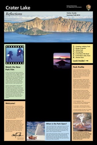
  • 1. Reflections Summer/Fall 2013 Visitor Guide Watch the New Park Film A new, 22-minute film has just arrived at the Steel Visitor Center—the park’s first new orientation film since the 1980s! Covering a variety of topics, the film explores the significance of Crater Lake and the wonder it has inspired for generations. The film is called “Crater Lake: Into the Deep” and includes dramatic underwater footage as well as state-of-the-art animation that depicts the park’s violent geologic past. The film is shown daily on the hour and half-hour from 9:00 a.m. to 4:30 p.m. The auditorium in the Steel Visitor Center is small, so watching the film in the early morning or late afternoon is recommended to avoid crowded conditions. Production of the film was funded entirely by entrance fees paid by park visitors like you. By visiting the park, you are contributing to future improvements. Thanks for your support! Plus 10 Other Ways to Enjoy Your Park Watching the sun rise (or set) over Crater Lake can be an unforgettable experience. With clean air, clear skies, and unobstructed views, the park is usually a fantastic place to observe the sun’s daily rituals, as well as other celestial events. In fact, for many travelers, spending dawn or dusk on the rim of Crater Lake is a highlight of their visit. Opinions differ, though, as to the best vantage points. At dawn, some people head to Discov- ery Point or Watchman Overlook, both along the West Rim Drive. From these locations (and from the top of Watchman Peak, where the photo on the right was taken), the waters of the lake sometimes glow in shades of orange, pink, and purple. As soon as the sun breaks the horizon, however, seeing the lake from these spots means staring into the light, and opportunities for photographs diminish. That’s why many people prefer to station themselves at sunrise along the East Rim Drive (or hike to the summit of Mount Scott, where the photo at top was taken), so as to have the sun at their back when viewing the lake. That’s also why, at sunset, most rangers recommend driving to Watchman Overlook or joining a ranger-led hike to the top of Watchman Peak (see page 3), where you’ll catch the last rays of light on the lake’s surface then watch the sun descend over a dozen mountain ridges between the park and the Pacific Ocean. In the meantime, here are 10 other tips for making your visit to Crater Lake more meaningful, memorable, and fun: When is the Park Open? Crater Lake National Park is open year-round, 24 hours a day. Some roads, trails, and facilities, however, are closed seasonally due to snow. Much of the year, the park’s North Entrance Road and Rim Drive are closed to cars. They close for the season on November 1 (or earlier if there is significant snowfall). Crews begin plowing these roads in April, but opening dates vary. The North Entrance Road and West Rim Drive tend to open in early June. The East Rim Drive typically opens in early July. Highway 62 is open year- round. The road to Rim Village is also open year-round, except after heavy snowstorms. National Park Service U.S. Department of the Interior Crater Lake Welcome! Thank you for visiting your national park. Here at Crater Lake, you’ll find opportunities to refresh your spirit, awaken your senses, and connect with the natural world. This year, you may notice that budget reductions are having some effects on available services and facilities. Please know that we are work- ing hard to ensure that every dollar we do have is used in the most efficient manner to protect the park and provide you with the best experience possible. The National Park Service protects more than 400 special places, saved by the American people so that everyone can experience our heritage. We at Crater Lake are proud to be stewards of this national treasure. Park rangers and maintenance staff are here to assist you in making your visit safe, rewarding, and fun. If there is anything we can do to help, please ask. Enjoy your park! Craig Ackerman Superintendent Drive Around the Lake Rim Drive is a 33-mile (53-km) road that encircles Crater Lake. More than 30 pullouts offer dramatic views of the park’s volcanic scenery. Allow 2 to 3 hours (see page 5). Hike a Trail From easy walks to challenging hikes, the park has something for everyone. Explore pristine forests, flower-filled meadows, and rocky peaks (see page 4). Attend a Ranger Program Discover the wonders of Crater Lake with those who know the park best. Talks, walks, kids programs, boat tours, and trolley tours are offered daily (see page 3). Find the Phantom Ship Anchored near the lake’s south shore is an island that seems to be sailing away. To see it, hike to Sun Notch or drive to the viewpoint named in its honor (see page 5). Visit the Pinnacles Formed during the same eruption that gave birth to the lake, these colorful volcanic spires are tucked away in the park’s southeast corner (see page 5). Tour Crater Lake Lodge For a glimpse into an earlier era, check out the history exhibits—and walk through the Great Hall—of Crater Lake Lodge, renovated in the 1990s but first opened in 1915 (see page 2). Visit the Sinnott Memorial Overlook With panoramic views and fascinating exhibits, this is the place to learn about the park’s geologic story and history of scientific investigation (see page 2). Have a Picnic The viewpoints and picnic areas along Rim Drive are perfect for outdoor eating (see page 5). Stop by the Rim Village Café for grab-and-go sandwiches, salads, and snacks. Relax Find a peaceful spot and attune yourself to the sounds and rhythms of the park. The Lodge veranda and the quiet pullouts on the lake’s north side are favorite spots to unwind. Touch the Water The trail to the lake shore is steep, dusty, and often crowded, but the water at the bottom is some of the world’s purest. Swim, fish, or simply dangle your toes (see page 3). Snow plow at Rim Village Park Profile Crater Lake National Park protects the deepest lake in the United States. Fed by rain and snow (but no rivers or streams), the lake is considered to be the cleanest large body of water in the world. The water is exceptional for its clarity and intense blue color. The lake rests inside a caldera formed approximately 7,700 years ago when a 12,000-foot-tall (3,600-meter) volcano collapsed following a major eruption. The eruption may have been the largest in North America in the past 640,000 years. Later eruptions formed Wizard Island, a cinder cone near the southwest shore. Today, old-growth forests and open meadows blanket the volcano’s outer slopes, harboring a variety of plants and animals, including several rare species. The area is central to the cultural traditions of local American Indian tribes, and the park provides unique opportunities for scientific study and public enjoyment. • Park established: 1902 • Size: 183,000 acres (74,060 hectares) • Visitors per year: About 500,000 • Lake depth: 1,943 feet (592 meters) • Lake width: 4.5 to 6 miles (7 to 10 km) • Annual snowfall: 43.5 feet (13.2 meters) • Last time the lake froze over: 1949 Artist Paul Rockwood’s conception of Mount Mazama, the volcano that collapsed to form Crater Lake. If you gathered up the ash from Mount Mazama’s catastrophic eruption and spread it evenly across the state of Oregon, it would form a layer 8 inches (20 cm) thick. 2 3 4 5 6 7 8 Look Inside!  ... Camping, Lodging, Food ... Ranger Programs ... Hiking Trails ... Driving Map ... In the News: Rim Road ... In the News: Lidar, Foxes ... Climate Chart Catch a Rising Star
  • 2. Crater Lake National Park belongs to everyone. We all share respon- sibility in protecting it. Please take a moment to become familiar with these important regulations. For a full list of the park’s rules, visit www.nps.gov/crla/parkmgmt/ lawsandpolicies.htm. Camping Camping is limited to developed campgrounds and some backcountry areas. Permits are required for backcountry camping (see page 3). Driving Use pullouts to enjoy the views. Do not stop in the road. Observe posted speed limits, and watch for wildlife, bicyclists, and pedestrians. Off-road travel is prohibited. Fires Fires are allowed only in designated rings in the Rim Village Picnic Area and campgrounds. Fires may be re- stricted at certain times; ask a ranger. Food Store food properly. Generally, this means sealed in your vehicle or a campground food locker. Backcoun- try campers should use bearproof canisters or hang food from a tree. Exposing wild animals to our food alters their behavior, is bad for their health, and can be dangerous for us. Hiking and Climbing Stay on trails. This prevents erosion, protects vegetation, and protects other hikers. Shortcutting trails is prohibited. Hiking and climbing inside the caldera are strictly prohibited. The only exception is the Cleetwood Cove Trail, the only safe and legal access to the lake shore. Serious injuries and deaths have occurred from falls inside the caldera. The walls consist of steep, unstable rocks and soils. Park Features Leave rocks, plants, animals, and artifacts undisturbed for others to enjoy. Collecting, defacing, destroy- ing, or disturbing natural, cultural, or historical features is prohibited. Pets Pets on a leash—or otherwise physically restrained—are welcome in the park, but only in developed areas. They are allowed within 50 feet (15 meters) of roads, estab- lished parking areas, developed campgrounds, and designated picnic areas. Pets are not allowed inside buildings, including Crater Lake Lodge and The Cabins at Maz- ama Village. Pets are not allowed on park trails or in the backcountry. The presence of pets can confuse and frighten wild animals, affecting their behavior. The above rules do not apply to service dogs here to assist people with disabilities. Good places to walk a dog include Rim Village, Mazama Campground, and Grayback Drive. Solid pet ex­ crement must be picked up imme- diately by the owner or person in control of the pet and disposed of in a trash or solid-waste receptacle. Viewpoints Stay back from the rim of the caldera. Do not go beyond established fences and rock walls. Falling may cause injury or death. Weapons Firearms are prohibited in all posted park buildings. Wildlife Never feed wildlife. This includes birds and squirrels. Feeding animals is dangerous for you, bad for them, and harmful to the ecosystem. Feeding, touching, disturbing, or approaching wildlife is prohibited. Accessibility Except for the Sinnott Memorial Overlook, developed areas in the park are generally ac- cessible to individuals with mobility impair- ments. Wheelchair- accessible paths include the Rim Village prom- enade and the Pinnacles Trail. The Godfrey Glen Trail and Plaikni Falls Trail are accessible to wheelchair users with assistance (see page 4). Multiple pullouts on Rim Drive have wheel- chair-accessible wayside exhibits. Some ranger programs are accessible to people with limited mobility and other im- pairments (see page 3). We are working hard to improve our level of accessibility for all park visitors. We welcome your comments. ATMs The Mazama Village Store and Rim Village Gift Shop have ATMs. Drinking Water Water faucets can be found at Rim Village, Mazama Village, and inside the Steel Visitor Center. Bottled water can be purchased at the Rim Village Café, the Mazama Village Store, and the bottom of the Cleetwood Cove Trail (when boat tours are operating). Emergencies Dial 911 to report any emergency, 24 hours a day. First aid is available at visitor centers and the ranger station at Park Headquarters. Entrance Fee The entrance fee for Crater Lake National Park is $10 per family car, good for 7 days. The rate is higher for commercial vehicles. Your fees are put to work improving visitor services and facilities. Thank you for support- ing your national parks! Gasoline Self-serve gasoline is available at Mazama Village from May 24 through October 14. Internet Wireless internet is free for guests of Crater Lake Lodge and The Cabins at Mazama Village. Pub- lic Wi-Fi is available at Crater Lake Lodge and the Annie Creek Restau- rant for $4 per hour or $10 for 24 hours. Lost & Found Contact a ranger at either visitor center or call 541-594-3060. Phones Cell phone coverage in the park is unreliable. Reception depends on your location and provider. Pay phones are located outside the Mazama Village Store and inside Crater Lake Lodge. Picnic Areas Picnic areas are found throughout the park (see page 5). The Rim Village picnic area has fire grates. Most picnic areas have vault toilets but no running water. Post Office A U.S. Post Office is open Monday through Satur- day in the Steel Visitor Center. Summer hours are 9:00 a.m.–noon and 1:00–3:00 p.m. Recycling Combination trash/ recycling bins can be found around the park at more than 20 locations. Recycling is currently limited to aluminum cans and plastic bottles. All bins can accept both. Restrooms Restrooms with flush toilets and running water are located at Rim Village, Mazama Village, and the Steel Visitor Center (9:00 a.m.–5:00 p.m.). Vault toilets are located at most picnic areas, Watchman Overlook, and both ends of the Cleetwood Cove Trail (see map on page 5). Showers & Laundry Coin-operated showers and laundry machines are available at Mazama Campground. Camping The park has two campgrounds. Both sit in forests south of the lake. Holders of an Amer- ica the Beautiful Senior Pass or Access Pass are entitled to a 50% discount. Mazama Campground (212 sites) is located 7 miles south of Rim Village near Highway 62. In 2013, it will be open from May 31 through October 6, weather permitting. 75% of the campsites for July, August, and September are reservable in advance by calling 1-888-774- 2728 or online at www.craterlakelodges.com. The rest are available on a first-come, first- served basis. Typically, there are sites available until late afternoon or early evening. The campground offers tent sites ($21 per night) as well as RV sites ($29). Some of the RV sites have electric hookups ($35). There are many pull-through sites; some can accom- modate RVs as long as 50 feet (15 meters). Each site has a picnic table, fire ring, and food locker. Black bears are rarely seen, but camp- ers are advised to store all food in their locker or their vehicle. The campground has drink- ing water, flush toilets, public showers, and laundry facilities. A nearby general store sells groceries, firewood, and gasoline. You can contact the campground directly during the summer at 541-594-2255 ext. 3610. Mazama Campground is operated by the park’s concessioner, Xanterra Parks & Resorts. Unfortunately, Lost Creek Campground (16 tent sites) will be closed in 2013 due to budget cuts. Most years, it opens in early July and closes in mid-October. It is located on the spur road to the Pinnacles Overlook. Registration ($10 per night) is self-service, and reservations are not taken. It has drinking water and flush toilets. Each site has a picnic table, fire ring, and food locker. Lost Creek Campground is operated by the National Park Service. We hope to reopen it in 2014. For a list of camping options outside the park, ask at either visitor center. Food & Dining The park has three restaurants and one store. The Crater Lake Lodge dining room offers fine dining in a casual lodge atmosphere. The menu features gourmet Northwest cuisine made with local ingredients. Reservations are recommended for dinner (5:00-9:00 p.m.) but are not taken for breakfast (7:00-10:30 a.m.) or lunch (11:30 a.m.-2:30 p.m.). Appetizers, drinks, and desserts are also available, without reservations, from 2:30-9:00 p.m. in the Great Hall and on the veranda. Dinner reservations can be made by calling 541-594- 2255 ext. 3217. In 2013, the dining room will be open from May 17 through October 13. The Annie Creek Restaurant, located in Mazama Village, is also open for breakfast, lunch, and dinner (7:00 a.m.-9:00 p.m. during the peak season, June 21-September 2). Options include gourmet burgers, vegetarian lasagna, a soup & salad bar, and pizza, includ- ing take-out. Wireless internet is available at $4 per hour. In 2013, the restaurant will be open from May 24 through at least September 16, and possibly through October 6. The Rim Village Café serves lighter fare including salads, soup, snacks, breakfast pastries, and grab-and-go sandwiches. The café is open year-round. Peak season hours are 9:00 a.m.-8:00 p.m. (June 14-September 2). The Mazama Village Store sells groceries, camping supplies, firewood, and gasoline. Peak season hours are 7:00 a.m.-9:00 p.m. (June 17-September 3). Lodging The park has two motels, both operated by Xanterra Parks & Resorts. For information and reservations, call 1-888-774-2728 or visit www.craterlakelodges.com. For lodging op- tions outside the park, ask at a visitor center. Crater Lake Lodge (71 rooms) is located in Rim Village, overlooking the lake. In 2013, it will be open from May 17 through October 13. Reservations are highly recommended well in advance. The Cabins at Mazama Village (40 rooms) are located 7 miles south of Rim Village. Operating dates for 2013 are May 24 through September 29. Visitor Centers There are two visitor centers in the park. Rangers are available to answer your ques- tions and assist with trip-planning. The Crater Lake Natural History Association sells books, maps, postcards, and other items (see page 8). The Steel Visitor Center, located at Park Headquarters, is open daily from 9:00 a.m. to 5:00 p.m. A new, 22-minute orientation film is shown on the hour and half-hour (see page 1). The Rim Visitor Center, located in Rim Village, is open daily from 9:30 a.m. to 5:00 p.m. from June through late September. Exhibits The Sinnott Memorial Overlook, perched on a rock ledge behind the Rim Visitor Cen- ter, features an enclosed exhibit room and an open parapet with spectacular views of the lake. The overlook contains a relief model and exhibits on the park’s geologic story and lake research. Ranger talks are presented daily from June 28 through September 2 (see page 3). The overlook is open daily (weather permitting) from late June through October. Hours are 9:30 a.m.-6:30 p.m. in July and August, 9:30 a.m.-5:00 p.m. in June and Sep- tember, and 10:00 a.m.-4:00 p.m. in October. The overlook is located down a steep, historic walkway with stairs and, unfortunately, is not accessible to people with limited mobility. Crater Lake Lodge features exhibits on the history of tourism in the park and the history and renovation of the lodge. The exhibits are open daily, around-the-clock, from May 17 through October 13. They are located on the ground floor, west of the lobby. Gifts & Books The Rim Village Gift Shop is open all year. Peak season hours are 9:00 a.m.-8:00 p.m. (June 14-September 2). The Annie Creek Gift Shop in Mazama Village opens May 24 and will close sometime between September 16 and October 6. Peak season hours are 8:00 a.m.-9:00 p.m. (June 21-September 2). Both gifts shops are operated by Xanterra Parks & Resorts. You can also shop online at www.craterlakelodges.com/shop. A different selection of books and gifts is also available at the park’s two visitor centers (see page 8). Services & Facilities 2 Crater Lake Visitor Guide Summer/Fall 2013 This is the official trip-planner and news- paper of Crater Lake National Park. It is published twice a year and funded by the Crater Lake Natural History Association through sales made in the visitor center bookstores. Park Mailing Address: P.O. Box 7, Crater Lake, OR 97604 Phone: 541-594-3000 Website: www.nps.gov/crla E-Mail: crla_information_requests@nps.gov National Park Service U.S. Dept. of the Interior Know the Rules Golden-Mantled Ground Squirrel Rim Visitor Center Bicyclist on East Rim Drive Exhibits at the Sinnott Memorial Overlook Help Keep Wildlife Wild. Please DO NOT FEED! Clark’s Nutcracker Wizard Island
  • 3. Join a park ranger for a 2-hour cruise around Crater Lake. See the box below for departure times and ticket prices. Boat tours on Crater Lake are operated by Xanterra Parks & Resorts in partner- ship with the National Park Service. Tickets Each boat holds 37 passengers. 20 tickets for each tour (July 6-Sept. 2 only) are available for advance purchase by calling 1-888-774-2728 or online at www.craterlakelodges.com. The remaining 17 tickets for each tour (and all tickets from June 28-July 5 and Sept. 3-Sept. 15) are available only in the park from automated kiosks inside Crater Lake Lodge and the Annie Creek Gift Shop. For each tour, these tickets go on sale exactly 24 hours in advance. Sales continue until the tour is sold out or until 2 hours remain before departure. At that time, if a tour is not sold out, remaining tickets can be purchased from a ticket booth (open daily at 8:30 a.m.) at the top of the Cleetwood Cove Trail, until 45 minutes before departure. Ticket holders should arrive at the trailhead at least 45 minutes before their tour to allow time to hike down the 1.1-mile (1.7-km) trail to the lake. Visiting Wizard Island Up to 74 tickets each day are available for visitors wishing to disembark at Wizard Island, halfway through the tour, to hike, fish, swim, and explore. Only 2 tours dock at Wizard Island: the 9:30 a.m. and 12:30 p.m. departures. The 6 standard tours do not stop. Most passengers are dropped off for a 3-hour stay, then picked up by a later boat to complete their tour of the lake. A limited number of tickets (6 per day) are available for people wishing to spend 6 hours on the island. See page 4 for details on the island’s 2 hiking trails. What to Bring Bring plenty of drinking water. Bottled water is available for purchase at the bottom of the Cleetwood Cove Trail. Bring a lunch or snack, especially if visiting Wizard Island. Light snacks are available for purchase at the top of the Cleetwood Cove Trail. Sunscreen, sunglasses, and a hat are recommended for sun protection. The boats are not covered. Bring a jacket. Weather on the lake can be windy and chilly. Wear sturdy footwear, especially if visiting Wizard Island. Hiking to Cleetwood Cove The Cleetwood Cove Trail is the only legal access to the shore of Crater Lake (see map on page 5). The hike is steep and strenuous: in 1.1 miles (1.7 km) it drops 700 feet (213 meters) in elevation. Walking back up is equivalent to climbing 65 flights of stairs! The trail is recommended only for those in good physical condition. It should not be attempted by anyone with heart, breathing, or walking problems. It is not accessible for people with mobility impairments. Hikers should wear sturdy shoes and carry water. Vault toilets are located at the top and bottom of the trail. Depending on snow conditions, the trail usually opens in late June and closes in late October.      Kids: You Can Become a Junior Park Ranger! Are you between 6 and 12 years old? Do you want to learn while having fun at Crater Lake National Park? Here are 2 different ways: • Pick up a free activity book at either visitor center. Explore the park, complete the activities, then return the book to a ranger to earn a Junior Ranger BADGE. • Meet behind the Rim Visitor Center at 1:30, 3:00, or 4:30 p.m. (June 28-Sept. 2) and participate in a free, 20-minute activity. Complete one activity to earn a Junior Ranger PATCH. Backcountry Camping Over 95% of the park is managed as wilderness. Although some areas are closed to backcountry camping (for example, there is no summer camping with a view of the lake), exploring the park’s old-growth forests and volcanic landscapes can be a rewarding experience. All campers not staying in the park’s developed campgrounds must ob- tain a backcountry permit. The only exception is through-hikers on the Pacific Crest Trail, who may instead sign the trail register as they enter the park. Permits are free and are available at Park Headquarters, from the visitor center or ranger station, between 9:00 a.m. and 5:00 p.m. Bicycling Bicycling at Crater Lake is allowed on paved roads and on the unpaved Grayback Drive. Bicycles are not allowed on park trails, with one exception: the Pinnacles Trail. Park roads are narrow with few shoulders and considerable automobile traffic. Helmets are Activities The Cleetwood Cove Trail drops 700 feet (213 meters) to the lake shore. Sketch from Road Guide to Crater Lake. Boat Tours required for persons under 16 years of age and are strongly recommended for all cyclists. Bicycling on park roads is physically demanding yet can be exceptionally rewarding. The most popular route is the 33-mile (53-km) Rim Drive, featuring spectacular views but also long, steep grades and climbs totaling 3,800 feet (1,158 meters). For details, pick up a bicycling handout at either visitor center. Fishing Originally, Crater Lake contained no fish. Between 1888 and 1941, however, 6 species were intro- duced. Today, only rainbow trout and kokanee salmon remain. Fish- ing is allowed at the bottom of the Cleetwood Cove Trail, where you’ll find .25 miles (.4 km) of rocky shoreline. Wizard Island, reachable by tour boat, is also open to fishing. Fishing licenses are not required. There are no restrictions on the size, number, or species taken. Cleaning fish in the lake is prohibited; pack out your catch. To prevent the introduction of non-native organisms, no organic bait of any kind may be used. This includes fish eggs, PowerBait, and live or dead fish. Fishing is limited to artificial lures and flies only. Swimming Swimming is allowed in Crater Lake, but the water is cold! Most people swim for just a few minutes. Swimming is permitted only at Cleetwood Cove and at Wizard Island, which requires a boat tour to reach. The shoreline at both loca- tions is rocky; there are no beaches. Snorkeling, scuba diving, and long- distance swimming are not allowed. Last year, after assessing the threats posed by aquatic invasive species, the park placed a ban on the use of snorkels, wet suits, diving gear, and other equipment that could serve as vectors for the introduction of non-native organisms. We hope you will understand our caution on this issue and the importance of pro- tecting the lake from a threat to its ecology that could be irreversible. Wildlife Viewing The park is home to many animals, but they can be difficult to spot. The most visible animals are deer and squirrels. Herds of elk are some- times seen in the meadows along Rim Drive. Bobcats and mountain lions are present but rarely seen. Lucky observers might spot a fox, black bear, marmot, porcupine, grouse, or bald eagle. Dawn and dusk are the best times to look. Boat Tour on Crater Lake Sunset over Crater Lake Trolley Tour on Rim Drive Ranger-Led Activities June 28–Sept. 2 May 17–June 27 & Sept. 3–Oct. 13 Ranger Talks at Rim Village Join a ranger to deepen your understanding of Crater Lake. Topics vary; check posted schedules. Meet at the Sinnott Memorial Overlook for the talks at 11:30, 1:00, and 2:30. Meet on the back porch of Crater Lake Lodge (accessible to wheelchairs) for the 4:00 talk. (20 minutes) 11:30 a.m. 1:00 p.m. 2:30 p.m. 4:00 p.m. Check posted schedules Junior Ranger Activity Kids participate in a ranger-led activity to learn about Crater Lake and earn a Junior Ranger patch. Meet behind the Rim Visitor Center. Geared for ages 6 to 12. (20 minutes) 1:30 p.m. 3:00 p.m. 4:30 p.m. Check posted schedules Afternoon Hike Hike with a ranger to discover Crater Lake. Trails vary by day of the week. See page 4 for trail details. For Garfield Peak, meet on the back porch of Crater Lake Lodge. For Sun Notch and Plaikni Falls, meet at the trailhead. Be sure to carry drinking water. Sunday, Wednesday: Sun Notch (1 hour, easy, great views of the Phantom Ship) Mon., Thurs., Sat.: Plaikni Falls (1.5 hours, easy, hike to a hidden waterfall) Tuesday, Friday: Garfield Peak (2.5 hours, strenuous, spectacular lake views) 2:00 p.m. Check posted schedules Watchman Peak Sunset Hike Ascend to a breathtaking viewpoint and watch the sun go down over the Cascade Mountain Range. Meet at the Watchman Overlook, a parking area with wooden fences 3.8 miles (6.1 km) northwest of Rim Village. Flashlights are not needed. See page 4 for trail details. (1.5 hours) July 5-31 7:30 p.m. August 1-10 7:15 p.m. August 11-20 7:00 p.m. August 21-31 6:45 p.m. (Hike is offered from July 5-Sept. 10) Sept. 1-10 6:30 p.m. Evening Program Relax under the stars as you learn about the park. Check posted schedules for topics. Meet at the Mazama Campground Amphitheater, between loops D and E. (45 minutes) June 28-July 31 9:00 p.m. August 1-20 8:30 p.m. Aug.21-Sept.2 8:00 p.m. Check posted schedules Rim Drive Trolley Tour 10:00 a.m. 11:00 a.m. 12:00 p.m. 1:00 p.m. 2:00 p.m. 3:00 p.m. Check posted schedules Crater Lake Boat Tour For a different perspective on Crater Lake, take a ranger-narrated boat tour. See the right-hand column of this page for detailed information. Note: Taking a boat tour requires hiking down— and back up—one of the steepest trails in the park. Tours cover a variety of topics. (2 hours) Standard Tours: 9:35 a.m. 10:30 a.m. 11:30 a.m. 1:30 p.m. 2:30 p.m. 3:30 p.m. Tours with Wizard Island Drop-Offs: 9:30 a.m. 12:30 p.m. Weather permitting, boat tours will operate from June 28 through September 15 Activities are free of charge except for trolley & boat tours. Programs are subject to cancellation due to weather or unforeseen circumstances. Ticket Prices $35 Adult (age 13 and up) $45 Adult with Wizard Island Drop-Off $21 Child (age 3* through 12) $27 Child with Wizard Island Drop-Off *Kids must be at least 3 years old to take a boat tour. Engine noise, sun exposure, wind, and occasional rough water make tours extremely unpleasant for infants and toddlers. 3 Ticket Prices $25 Adult (age 14 through 59) $22 Senior (age 60 and up) $15 Child (age 5 through 13) Free Young Child (under 5 years) $70 Family Rate (2 adults plus kids) Circle the lake on a ranger-narrated tour of Rim Drive. See the top of this page for more infor- mation. Tours leave from, and tickets are sold at, the Community House in the middle of Rim Village. Tickets may be purchased the day of the tour, or the day before, from 9:30 a.m. to 3:00 p.m. To reserve tickets further in advance, call 541-882-1896 or visit www.craterlaketrolley.com. Tours cover a variety of topics. (2 hours) Trolley Tours Rim Drive is one of America’s most scenic byways, but it’s hard to appreciate the views with your eyes on the road. Fortunately, you can leave the driving to someone else. Ranger-guided trolley tours circle Crater Lake daily. Tours begin and end at Rim Village, spend 2 hours traveling clockwise around the lake, and stop at a minimum of 4 scenic overlooks. See below for departure times and ticket prices. The buses are enclosed, climate-controlled, wheel- chair accessible, and seat 25 passengers. They resemble old streetcars, but they run on modern technology: powered by compressed natural gas, they emit 30-40% less pollution than gasoline-powered vehicles. The trolleys are owned and operated by The Shuttle Inc. of Klamath Falls.
  • 4. Hi, I’m Ranger Emily. We have 90 miles (145 km) of hiking trails here at Crater Lake. Our most popular day hikes are listed on this page. If you are visiting in June or July, be aware that some trails might still be closed by snow. Please help us protect this special place by following a few important rules: No hiking or climbing inside the caldera! The walls are dangerously steep and unstable. The one exception is the Cleetwood Cove Trail, the only legal access to the lake shore. Leave all rocks, plants, animals, and artifacts undisturbed for the enjoyment of future hikers. Overnight backpacking requires a permit, available at Park Headquarters between 9:00 a.m. and 5:00 p.m. Some areas are not open to backcountry camping. To protect vegetation and prevent erosion, please stay on the trails. Pets are not allowed on park trails (see page 2). Let’s Go Hiking! Hiker atop Garfield Peak Lewis Monkeyflower on the Castle Crest Trail The Phantom Ship from Sun Notch Discovery Point Trail Fumarole Bay Watchman Peak Annie Creek 2.2 miles (3.5 km) Total Distance 1.8 miles (2.9 km) 1.6 miles (2.6 km) 1.7 miles (2.7 km) loop trail 100 feet (30 meters) Elevation Gain 150 feet (46 meters) 420 feet (128 meters) 200 feet (61 meters) 1 hour Time 1 hour 1 hour 1½ hours Lake Views Highlight Swimming, Fishing Panoramic Views Creek, Canyon, Flowers Trail along the rim of Crater Lake through a pretty forest of whitebark pines and mountain hemlocks. Fine views of the lake and Wizard Island. Use caution near cliff edges. Description Rocky trail along the shore of Wizard Island. Becomes hard to follow after reaching Fumarole Bay. The shallow, clear water is good for fishing and swimming. Moderate ascent to a lookout above Wizard Island. Spectacular views in all directions. Great place to watch the sunset. Trail may be closed until mid-July due to snow. Moderately strenuous trail through a deep, stream- cut canyon. Lots of water, wildflowers, and sometimes wildlife. Self-guiding brochures are available at the trailhead. West end of Rim Village, where the paved walk be- comes a dirt path. Can also start from Discovery Point. Trailhead Location Wizard Island dock, accessible only via a boat tour from Cleetwood Cove. See page 3 for information. 3.8 miles (6.1 km) northwest of Rim Village. Park at the viewpoint surrounded by wooden fences. Mazama Campground, behind the amphitheater, located between loops D and E. Limited parking in E Loop. Gold prospector John Wesley Hillman first spotted Crater Lake from this point in 1853. Nature Note Abundant lichen on the tree trunks is an indication of excellent air quality. Built in 1932, the peak’s historic fire lookout is still staffed by rangers today. The creek provides the park’s drinking water, named the best tasting in Oregon in 2004. Moderate Castle Crest Lady of the Woods Sun Notch Trail The Pinnacles Godfrey Glen Plaikni Falls 0.5 miles (0.8 km) loop trail 0.5 miles (0.8 km) loop trail 0.9 miles (1.4 km) loop trail Total Distance 1 mile (1.6 km) 1 mile (1.6 km) loop trail 2.2 miles (3.5 km) 100 feet (30 meters) 120 feet (37 meters) 150 feet (46 meters) Elevation Gain 10 feet (3 meters) 50 feet (15 meters) 100 feet (30 meters) 30 minutes 30 minutes 30 minutes Time 30 minutes 30 minutes 1 hour Flowers, Meadow, Creek Historic Architecture Views of Phantom Ship Highlight Volcanic Spires Peaceful Forest Waterfall, Flowers Loop trail through a beautiful meadow. Abundant wild- flowers in July. The trail is rocky and slippery in places. Self-guiding brochures are available at the trailhead. Loop trail around Park Headquarters. Self-guiding brochures, available at the trailhead, describe how early park architects integrated their designs with the natural landscape. Short uphill walk through a meadow to the rim of Cra- ter Lake. Great views of the Phantom Ship. Use caution near cliff edges. Trail improve- ments are underway. If you see our trail crew, say hello! Description Easy walk along the rim of Pinnacle Valley. Great views of volcanic spires. Use caution near cliffs. Trail ends at park boundary. Accessible to wheelchair users with assistance. Open to bicycles. Easy stroll through an old- growth forest, with some canyon views. Dirt path; accessible to wheelchair users with assistance. Self-guiding brochures are available at the trailhead. New trail (opened in 2011) through a quiet old-growth forest to a waterfall. The first 3/4 of the way is accessible to wheelchair users with assis- tance, but the final ascent to the falls might be too steep. East Rim Drive, 0.5 miles (0.8 km) east of Park Head- quarters. Can also access from the Steel Visitor Center. Behind the Steel Visitor Center, on the south side of the building. East Rim Drive, 4.4 miles (7.1 km) east of Park Headquarters. Trailhead Location End of the Pinnacles Spur Road, 7 miles (11.3 km) southeast of the Phantom Ship Overlook. 2.4 miles (3.9 km) south of Park Headquarters. Pinnacles Road, 1.2 miles (1.9 km) southeast of the Phantom Ship Overlook. The flowers here are nourished by springs emerging from the hillside. The trail’s name refers to a sculpture of a woman carved into a boulder along the trail. This U-shaped valley was carved by glaciers that once flowed down Mt. Mazama. Nature Note The Pinnacles are chimneys formed when hot ash cooled after the big eruption. Trail is named after William Godfrey, a ranger who died in a blizzard here in 1930. Snowmelt, not Crater Lake, is the source of Plaikni Falls’ water. Easy Easy 4 Wizard Summit Cleetwood Cove Garfield Peak Trail Mount Scott Crater Peak Union Peak 2 miles (3.2 km) 2.2 miles (3.5 km) 3.4 miles (5.5 km) Total Distance 5 miles (8.1 km) 6.4 miles (10.3 km) 11 miles (17.7 km) 760 feet (232 meters) 700 feet (213 meters) 1,010 feet (308 meters) Elevation Gain 1,250 feet (381 meters) 765 feet (233 meters) 1,600 feet (448 meters) 1½ hours 1½ hours 2 to 3 hours Time 3 hours 3½ hours 5 to 6 hours Views, Summit Crater Swim, Fish, Boat Tours Panoramic Views Highlight Panoramic Views Forest, Views, Solitude Panoramic Views Rocky climb to the top of Wizard Island. Spectacular lake views, interesting geology. A path leads around the 90-foot-deep (27-meter) crater at the summit. The only legal access to the shore of Crater Lake. Strenuous trail with a steep grade. The trail descends to a rocky shoreline at Cleetwood Cove. See page 3 for detailed information. Rocky climb to a high peak. Spectacular views along the way and at the top. Diverse plant life, many wildflowers. Top section may be closed until mid-July due to snow. Use caution near cliff edges. Description Gradual ascent of the park’s highest peak. Great views in all directions. Best in morning, when the light is ideal for lake viewing. May be closed until mid-July due to snow. Moderately strenuous walk to the summit of a small volcano. No lake views, but fine views of the Klamath Basin to the southeast. A peaceful walk through forests and meadows. Long forest walk followed by a very steep climb. Great views from the top and interesting geology, but no view of Crater Lake. Top section may be impassable until mid-July due to snow. Wizard Island dock, accessible only via a boat tour from Cleetwood Cove. See page 3 for information. North side of the lake, 11 miles (17.6 km) from Rim Village if traveling clockwise on Rim Drive. East end of Rim Village. Walk behind Crater Lake Lodge along the paved promenade. Trailhead Location East Rim Drive, 14 miles (22.5 km) east of Park Headquarters. East Rim Drive, 3 miles (4.8 km) east of Park Headquarters at the Vidae Falls Picnic Area. Highway 62 at the Pacific Crest Trailhead, 1 mile (1.6 km) west of the Crater Lake road junction. The dead trees at the summit have been killed by dwarf mistletoe, a parasitic plant. Below 200 feet (61 meters), the water in Crater Lake stays 38ºF (3ºC) year-round. Rocky slopes along the trail are home to American pikas and yellow-bellied marmots. Nature Note Mt. Scott is the park’s highest peak—8,929 feet (2,721 meters) in elevation. Upper Klamath Lake is the largest in Oregon, but its av- erage depth is only 14 feet. Union Peak is the core of an old volcano eroded by gla- ciers during the last Ice Age. Strenuous Strenuous Hikers at Plaikni Falls Swimmers at Cleetwood Cove
  • 5. Rim Drive is a 33-mile (53-km) road that encircles Crater Lake. It is one of America’s most scenic byways, with spectacular views in all directions. The loop is typically open from early July to late October. It can be driven, without stopping, in about an hour, but at least 2 to 3 hours are necessary to enjoy the varied sights. The road is narrow, so buses and motorhomes should use caution. There are more than 30 scenic pullouts along the route, many of which have roadside exhibits. Be sure not to miss these 7 “must-see” stops. For more information, pick up the excellent Road Guide to Crater Lake National Park (48 pages, $5.95) at either visitor center. Discovery Point Imagine seeing Crater Lake by accident. It was near this spot, on the back of a mule in 1853, that gold prospector John Hillman became the first European-American to stumble across what he called “Deep Blue Lake.” Watchman Overlook This pullout offers an unmatched view of Wizard Island, a cinder cone that erupted out of Crater Lake approximately 7,300 years ago. To find this unmarked pullout, drive 3.8 miles (6.1 km) west of Rim Village and look for a viewpoint lined with wooden fences. Cloudcap Overlook This overlook sits at the end of a 1-mile (1.6-km) spur road, the highest paved road in Oregon. Whitebark pines cling for survival here, dwarfed and contorted by the harsh winds. Pumice Castle Overlook Stop here to see one of the park’s most colorful features: a layer of orange pumice rock that has been eroded into the shape of a medieval castle. Watch carefully for this unmarked viewpoint, located 1.1 miles (1.8 km) west of the Cloudcap Overlook junction and 2.4 miles (3.9 km) east of the Phantom Ship Overlook. Phantom Ship Overlook Nestled against the shore, Crater Lake’s “other island” escapes detection by many park visi- tors. Though it resembles a small sailboat, the island is as tall as a 16-story building. It’s made of erosion-resistant lava, 400,000 years old— the oldest exposed rock within the caldera. Pinnacles Overlook This overlook is well worth the 7-mile (11-km) detour from Rim Drive. Colorful spires, 100 feet (30 meters) tall, are being eroded from the canyon wall. The Pinnacles are “fossil fumaroles” where volcanic gases rose up through a layer of volcanic ash, cementing the ash into solid rock. Vidae Falls Look for this cascading waterfall between Phantom Ship Overlook and Park Head- quarters. A spring-fed creek tumbles over a glacier-carved cliff and drops 100 feet (30 meters) over a series of ledges. In summer, wildflowers flourish in the cascade’s spray. Garfield Peak 8054ft 2455m Watchman Peak 8013ft 2442m Red Cone 7363ft 2245m 7025ft 2142m Grouse Hill 7412ft 2260m Oasis Butte Fragile wetlands, no camping Llao Rock 8049ft 2453m Scout Hill 6376ft 1944m Mount Scott (highest point in park) 8929ft 2721m 6091ft 1857m Sun Mountain 5550ft 1692m Crater Peak 7263ft 2214m Union Peak 7709ft 2350m Baldtop 6200ft 1890m Tom Mountain 6876ft 2096m Jerry Mountain Scoria Cone 6648ft 2027m Goose Nest 7249ft 2210m 4400ft 1341m Goose Egg 7124ft 2172m Sun Notch Trail Discovery Point Devils Backbone Phantom Ship Rim Café Gift Shop Sinnott Memorial Overlook Rim Visitor Center Crater Lake Lodge C G RAY BA CK SAND RIDGE THE PINNACLES ANDERSON BLUFFS SCO T T BLU FFS PUMICE DESERT PUMICE FLAT Wizard Island Annie Spring Entrance Station Annie Creek Trail Phantom Ship Overlook Cloudcap Overlook 7865ft 2397m North Junction Cleetwood Cove Trail (to tour boat landing) Castle Crest Trail Godfrey Glen Trail Lost Creek Pinnacles Overlook Deepest point below lake surface -1943ft -592m Average surface elevation: 6173ft 1882m Merriam Cone -486ft -148m -1548ft -472m -1788ft -545m 6940ft 2116m 7100ft 2165m 6004ft 1830m to Klamath Falls and to Roseburg, Bend, and Eugene Rim Village Mazama Village (ROGUE RIVER and WINEMA NATIONAL FORESTS) Pumice Castle Overlook Pinnacles Trail Discovery Point Trail Watchman Overlook Union Peak Trail Lightning Springs Trail Pacific Crest National Scenic Trail EAST RIM DRIVE (open summer only) EAST RIM DRIVE (open summer only) Pacific Crest National Scenic Trail to Annie Creek Restaurant Gift Shop PUMICE DESERT Pacific Crest National Scenic Trail Pacific Crest National Scenic Trail Lady of the Woods Trail (gravel road open to hikers, bicycles, horses, and pets, but closed to cars) RID G E Grayback Drive ParkBoundary Plaikni Falls DUTTON RIDGE (closed in 2013 due to budget cuts) W I N E M A N A T I O N A L F O R E S T W I N E M F S U N P A S S S T A T E F O R E S T Creek CreekCastle Creek Creek Creek W ildcat Creek M unsonCreek Creek Sun Creek Sun Creek Cavern Creek Cre ek Sand Bear ForkEast Annie Ann ie Castle Little Bybee Lightning Springs Annie Spring Whitehorse Ponds Stuart Falls Vidae Falls Sphagnum Bog Creek Dese Silent W heeler North Steel Visitor Center 6450ft 1966m Park Headquarters 230 138 62 97 to Medford and 62 97 5 CRATER LAKE NATIONAL PARK CRATER LAKE NATIONAL PARK S K Y L A K E S W I L D E R N E S S Cove Clee tw oodChaski Bay Fum arole B ay SkellChannel Crater Lake Grotto Cove Danger Bay Steel Bay Llao Bay WEST RIM DRIVE (open summer only) NORTH ENTRANCE ROAD (open summer only) Hiking Trail Groceries Food Service Lodging 4 0 1 2 3 4 5 Miles 5 Kilometers 1 2 30 Paved Road Unpaved Road Showers Gas Laundry Picnic Area Restrooms Restrooms (no water) Visitor Center Campground Wheelchair- Accessible Trail 5 5 97 97 20 199 230 138 138 58 62 62 234 62 Eugene Roseburg Klamath Falls to Po to Cal Bend Medford Ashland Grants Pass North Entrance Road Rim Drive are CLOSED in winter (see page 3) Chemult Chiloquin Union Creek Fort Klamath Prospect Crater Lake National Park Diamond Lake CRATER LAKE NATIONAL PARK CRATER LAKE NATIONAL PARK to Portland to Redding NATIONAL FORESTS NATIONAL FORESTS Highlights of the Rim Drive CRATER LAKE NATIONAL PARK The Pinnacles Regional MapArea of Detail View from the East Rim Drive
  • 6. Crater Lake Park one of the greatest pleasure grounds in the United States,” wrote The Ore- gonian, “equaling in attractiveness the famous Yellowstone Park.” The Medford MailTribune proclaimed: “This boulevard will be unlike any other in the world. Not only does it look down upon America’s deepest lake, lying like a blue amethyst in mystic beauty...but it affords a marvelous panorama of mountain scenery, of bleak hills and snowy peaks....” Even Super- intendent Arant couldn’t contain his enthu- siasm. In his 1912 annual report, he boasted that the circuit “will be beyond question one of the grandest scenic roads in the world.” Building the Rim Road, however, would prove to be easier said than done. Challenges included a short working season, deep snow that lasted well into summer, and a lack of mechanized equipment. Much of the work was done manually: by men and boys with picks and shovels. No accounts survive from those who performed the work, but the labor must have been backbreaking. Will Steel, who replaced William Arant as park superintendent in 1913, the year construction began, com- plained in his first annual report that “there is no provision for the comfort of the men, who, by the common laws of humanity, are entitled to shelter and...sanitary conditions.” He asked for $1,200 in order to erect, “without delay, a building containing a kitchen, dining room, bathroom, and sleeping quarters....” The Army Corps of Engineers supervised the road build- ing, but it was men from local communities, hired as laborers, who did the heavy lifting. As a result, progress slowed each July and August, when competition from ranching operations in the Klamath Basin caused some men to leave to harvest hay. In 1918, American involve- ment in World War I exacerbated the labor shortage. In truth, as much work was probably accomplished by horses as by humans. Teams of horses dragged plows, scrapers, and graders to smooth the roadbed. Several wood-fueled steam shovels also were employed to excavate rock. In 1914, the most productive year of the project, 250 men, 50 teams of horses, and three steam shovels managed to grade 14 miles of new road, with one crew moving clockwise around the rim and another counterclockwise. Work was completed in 1919, after seven summers of construction. All told, 57 miles of new road were now ready for the coming influx of automobiles, which were no longer limited to operating at only certain times of the day. Visitation skyrocketed. The number of tourists arriving at Crater Lake climbed from 16,000 in 1919 to more than 170,000 in 1931. The Rim Road, noted one observer, “is proving a wonderful attraction, second only to the beauty of the lake itself.” Upon circling the lake for the first time, Stephen Mather, the director of the National Park Service, gushed: “This road is one of the finest scenic highways in the world. Not only are the views of the marvelous lake superb and unique, but the glimpses of the surrounding region...are only slightly less sensational.” Yet all was not well. Despite its idyllic setting, the new “Skyline Boulevard” was in fact a narrow, rough, dusty road with sharp curves and steep grades. As passenger cars became larger and faster during the 1920s, the road’s narrow width—only 12 feet—made passage of vehicles in opposite directions hazardous. The road’s tight curves frustrated motorists who were becoming accustomed to higher speeds, and even new cars struggled to climb its steep- est hills, with grades of 10 percent. Further, the unsurfaced road was comprised, in places, of volcanic sand, in which some cars got stuck. And all vehicles kicked up clouds of finely pul- verized ash. “This dust,” complained Mather, “is puffed into the air by the wheels of the automobile, where it remains in suspension for a long time, filling the eyes and nostrils of the occupants...often obscuring the view.” Park staff lamented that “the continuous showers of fine, powdery dust” were “stunting and kill- ing” the vegetation. By 1930, new NPS director Horace Albright was declaring the Rim Road not only to be “the most beautiful highway in the world” but also “unfit for travel.” It needed to be paved, widened, and rerouted. After only a dozen years of use, the Rim Road had become obsolete, a victim of the era’s rapidly changing technology and expectations. Thus, in 1931, the park began construction of the present-day Rim Drive. While still quite narrow—and badly in need of repair, which is scheduled to occur in the next few years—its graceful curves, gentle inclines, and well- planned vistas continue to serve the park well. For long stretches, the Rim Drive overlaps the old Rim Road, and therefore obscures it, but vestiges of the old route remain. The so-called Grayback Drive, south of the lake (see page 5), is the best-preserved section. It’s not particu- larly scenic, and it’s no longer open to cars, but it’s a pleasant trail for running, mountain biking, and horseback riding. A much prettier segment of the Rim Road now serves as a spectacular (and little-used) hiking trail be- tween the West Rim Drive and the edge of the caldera. It can be followed for 2.5 miles (4 km) from the Lightning Springs Picnic Area, north past Watchman Overlook, over the shoulder of Hillman Peak, until meeting up with the Rim Drive a half-mile south of North Junction. Although Crater Lake’s “Skyline Boulevard” was abandoned soon after completion and is now largely forgotten, its legacy lives on. The first major construction project in the park’s history, it opened the park to mass tourism and spread excitement about the lake around the globe. And it paved the way (figuratively, at least) for the equally impressive Rim Drive that we enjoy today. It also inspired the fol- lowing piece of advice, as sound now as it was in the 1920s when park superintendent C. G. Thomson offered it to motorists setting out to drive along “the jagged crest of the world’s noblest crater.” Wrote Thomson: “Approach the experience in a leisurely and appreciative mood, and great will be your reward. For you will fix a gorgeous memory that neither time nor the fret of living shall efface.... And pay a tribute to the engineering genius that, while overcoming technical difficulties, contrived to alternate boundless panoramas with exquisite closeups of the tremendous caldera and its Olympian sapphire.” boats, and rainbow trout; and organized trips to the park for members of the political, sci- entific, and economic elite, whom he hoped to enlist as proponents of his agenda. The lobbying worked. Secretary of the Interior Richard Ballinger, for example, proclaimed upon visiting the park that “Crater Lake is a magnificent sight.... It should be thrown open to the tourist traffic of the world....” Steel also gained the support of Oregon’s congressional delegation. In 1909 he traveled to Washing- ton, DC, and pushed them to secure funding for a comprehensive road survey. When Con- gress appropriated $10,000 for this purpose in June of 1910, the editors of the Medford Mail Tribune cheered, noting wryly that “Senators Bourne and Chamberlain are to be congratu- lated.... For the first time in history, Southern Oregon has...actually secured something worthwhile by means of its delegation.” That summer, the Army Corps of Engineers sent a party of 26 men to Crater Lake to pre- pare plans, specifications, and cost estimates for an overhaul of the park’s road system, including new entrance roads from the south, east, and west. Upon arriving at the rim, the engineer in charge quickly became convinced that a “boulevard” around the lake was feasible. He expressed his intent to locate the road as “near to the edge of the crater as can be done at as many points as possible.” In the meantime, Will Steel was back in Washing- ton, DC, seeking funding for construction. In August of 1912, Congress allocated $50,000, which was followed, in subsequent years, by appropriations that totaled over $400,000 (roughly $8,300,000 in today’s dollars). With money thus secured, optimism ran high. Newspapers across Oregon trumpeted the nascent project. “The intention is to make 6 Rim Road Celebrates 100 Years Construction of the “Skyline Boulevard” Began in 1913 The 33-mile road around the rim of Crater Lake is one of America’s most scenic drives. Built from 1931 to 1940 using heavy machin- ery, it provides motorists with a stunning sequence of views of the lake and its sur- roundings. Few people realize, however, that the existing Rim Drive is not the only road to have circled Crater Lake. It follows the path of an earlier loop, known as the Rim Road, which was forged between 1913 and 1919 us- ing mostly manual labor. This summer marks the 100th anniversary of the construction of that original, remarkable road—dubbed the “Skyline Boulevard” by newspapers of the era—and thus seems a fitting time to recall the interesting, yet largely forgotten, story of its conception, construction, premature fate, and enduring legacy. It is no exaggeration to say that in 1902, when Crater Lake National Park was established, visiting the park meant mounting an expedi- tion. Most visitors reached the park only after a three-day wagon trip. There were no servic- es or facilities, and no roads reached the rim; seeing the lake required adventurers to aban- don their wagons and climb a steep trail on foot or horseback. Finally, in 1905, the park’s first superintendent, William Arant, oversaw the construction of a rough road from Park Headquarters to what’s now Rim Village. Even so, the first automobile to reach the rim, in 1906, did so only with the help of horses, which pulled the sputtering two-cylinder car up the steepest grades. “Very disagreeable” is how Superintendent Arant described the park’s road system in 1912, in his annual report to the Secretary of the Interior. “There are three wagon roads in the park.... They are simply tracks...cut out through the trees and bushes. By constant use these narrow roads have become veritable gutters the width of a wagon and in many places 1 or 2 feet deep.... being cut deeper and deeper by the wheels of vehicles passing over them.” The need for better roads was imperative, since more and more visitors were arriving by automobile. Ford Model Ts had begun rolling off assembly lines in Detroit, Michigan, in 1908; cars were becoming increasingly afford- able to a wide swath of the American public. The park, for its part, issued regulations that tried to accommodate motorized traffic, but wagons were still awarded right of way. Cars were required to stop in the presence of horses, limit speeds generally to six miles per hour, sound their horns at every bend in the road to warn oncoming travelers, and operate only between 6:30-10:30 a.m. and 3:30-6:30 p.m. so that horse-powered vehicles could move in peace and safety the rest of the day. Modes of travel may have been changing, but one thing was not: a full decade after its establishment, Crater Lake National Park was still remote and rugged, too rugged for most Oregonians to contemplate visiting. Reaching the rim was more hardship than adventure, and only one vantage point could be gained by wheeled vehicle. In 1912, only 5,235 peo- ple made the difficult journey to the park. The first clamor for a road around the lake came from William Steel. The park’s founder and greatest promoter, Steel was determined to popularize Crater Lake as a summer resort. He initiated construction of the park’s first hotel (Crater Lake Lodge, which would open in 1915); stocked the lake with row boats, tour To Build or Not To Build? That was the question at Crater Lake in the early 20th century. Most Oregonians favored increased access to the park and its sights, but opinions ranged as to the scope of development, as illustrated by the quotes below. Joaquin Miller was a poet who spent five days at Crater Lake in 1903 at the invitation of William Steel and came away deeply impressed by the lake’s tranquility. Steel was the park’s founder, first concessioner, and second superintendent. He longed for a day when tourists could visit the park with ease and promoted plans that went far beyond what was actually built. What do you think? Did development at Crater Lake proceed too far, not far enough, or have we achieved a balance between public enjoyment and preservation? “Much credit...is due to William Gladstone Steel for persistent hard work in estab- lishing this noblest natural park in the Republic, and the most unique park under the path of the sun.... It took such hold of my heart... that I love it almost like one of my own family. The thousand and one ‘best points of view’ from the rim of the crater keep you busy from morning to night. The plan is now to build...a drive around the lake, so that all these points may be considered in a single day from a carriage. And a great hotel is planned! ...Well, so be it, if you must so mock nature and break this hush and silence of a thousand centuries, but I shall not be here. No hotel or house or road of any sort should ever be built near this Sea of Silence. All our other parks have been surrendered to hotels and railroads. Let us keep this last and best sacred to silence and nature. That which is not worth climbing to see is not worth seeing.” “It is only a matter of time when a road will be built.... A tunnel... bored from the water to the Rim Road...and debris used to fill in along the shore line, for parking, turning, boat houses, and other conveniences.... However, the crown- ing glory of the park will consist of an au- tomobile road to the top of Mount Scott, 9,000 feet high, from which one beholds Central Oregon, from the Columbia River region far down into California and from the Blue Mountains to the Pacific Ocean. Walls will encircle the summit, where 200 cars or more can park with perfect safety and the occupants enjoy the entrancing thrills of mountain climbers without their hardships and dangers. Then will come a road inside the rim, near the water, crossing to Wizard Island and up to its crater and circling it. There inspired thoughts of reverence for the God of Abraham will sing His praises and...the praises of this wonderful lake and its environs.” Will Steel Joaquin Miller Tight, narrow curves made the Rim Road hazardous as cars grew larger and faster in the 1920s. Today’s Rim Drive The Rim Road was built by horses and hard work. Until the 1930s, when park roads were paved, deep sand and choking dust frustrated motorists. LIBRARYOFCONGRESS OREGONHISTORICALSOCIETY#23267 LIBRARYOFCONGRESS SOUTHERNOREGONHISTORICALSOCIETY#15290CRLAMUSEUMARCHIVECOLLECTIONS1596 Today, hikers can walk parts of the old Rim Road, such as this segment near Hillman Peak.
  • 7. If you happen to spot a fox this summer trot- ting along the rim of Crater Lake, you will likely be seeing one of the rarest mammals in North America. Scientists have recently deter- mined that the park’s red foxes are most likely members of the Sierra Nevada subspecies, a type that may soon be listed as threatened or endangered by the federal government. This discovery is good news for an animal whose entire population, just a few years ago, was thought to consist of perhaps just 20 indi- viduals near Lassen Peak in California. The red fox (Vulpes vulpes) is the most widely distributed terrestrial carnivore in the world, found across North America, Europe, Asia, and northern Africa. While thriving as a spe- cies, however, several of its subspecies are in peril. Of the 10 subspecies that occur in North America, three are found only at high elevations in the Rocky Mountains, Cascade Range, and Sierra Nevada. These “mountain foxes” were derived, it’s believed, from a single source population that was widespread in the western United States during the last Ice Age. Warming temperatures after the Ice Age pushed the foxes uphill, where they evolved into genetically distinct subspecies. Until recently, Oregon’s mountain foxes were assumed to be part of the Cascade subspecies, found in Washington State. The lineage of a red fox can’t be distinguished by looks alone; genetic testing is required. In 2012, researchers at Crater Lake set up a number of motion-sensitive cameras at loca- tions throughout the park. Across from each camera, on a tree trunk, they hung a scented lure (typically an animal carcass found along the highway). They then attached wire brushes to the trunk, hoping to snag a few hairs from any animal that came by later to investigate. At one of these “hair snare” sites, a red fox left behind some fur. Last winter, DNA analysis performed at the University of California, Davis, revealed that the donor fox is related to California’s mountain foxes and not those of Washington. The discovery of Sierra Nevada red foxes at Crater Lake is welcome news to scientists. It increases the known range of this most at-risk subspecies, now thought to be found all the way north to the Columbia River. Even so, the number of foxes remaining is anyone’s guess. They live in remote areas, at elevations of 5,000 feet (1,520 meters) and above. In the decades ahead, climate change is predicted to shrink their habitat even further, driving them up to isolated mountaintops and perhaps subjecting them to inbreeding. Other poten- tial threats include disease transmission from domestic dogs, trapping by humans (illegal in California but still allowed in Oregon), and competition from coyotes, who might also move uphill in response to warmer weather. Yet the biggest threat to the survival of these foxes might be our lack of understanding about their ecology. Few studies have been done on mountain foxes; the lack of data makes it difficult for scientists to assess the threats against them and assist in their recov- ery. That might change later this year, if the U.S. Fish and Wildlife Service determines that the subspecies warrants protection under the Endangered Species Act of 1973. If the fox is listed, funding for research will increase. In the meantime, Crater Lake staff are deploying additional “hair snares” this summer to gather more DNA evidence to provide definitive identification of the subspecies. You can help! If you see a fox in the park, snap a photo, make a note of the exact loca- tion, and contact a park employee as soon as possible. A photo is essential, since many fox sightings turn out to be coyotes, weasels, or marmots. (Coyotes have short tails with a black tip; foxes have long, bushy tails with a white tip.) Do not approach the animal, and do not attempt to lure or feed it. Foxes are quickly acclimated to human handouts, which increases their risk of car collisions and contact with domestic dogs. 7 Crater Lake Hit by Lasers Resulting Images are Proving Valuable Rare Fox Found in Park DNA Resembles That of Imperiled California Population In the summer of 2010, the presence of three small airplanes over Crater Lake National Park caused visitors to scratch their heads. For a week, the planes flew long, parallel paths across the sky, a few thousand feet above the ground. The entire time, lasers aboard each aircraft bombarded the park’s plants, rocks, and visitors with more than five billion pulses of light—at the rate of 83,000 hits per second. Fortunately, the infrared light was harmless and invisible, which is why the curiosity of onlookers never turned to concern. Little did everyone realize, though, that important scientific work was being conducted above them. Today, three years later, the results of this “lidar” survey are beginning to yield big benefits to park researchers and staff. Lidar is a technology that, among other things, can provide high-resolution images of the Earth’s surface. It’s similar in concept to radar, but uses light waves rather than radio waves. At its essence, it’s just a way of making a whole lot of very accu- rate distance measurements. Distance is calculated by meas- uring the time it takes each pulse of light to return from the ground (or whatever object it encounters first). The intensity of the returning light can also be used to derive information about the object’s physical characteristics. For the data to be meaningful, the position of the aircraft performing the survey must be precisely known, which is why an onboard GPS unit pinpoints the plane’s coordinates twice every second. In 2010, each square meter of the park was struck, on average, by eight pulses of light from above. Some of these pulses re- flected off the forest canopy, but many found gaps in the foliage and hit the ground, enough to produce a richly detailed map of the surface. For geologists, this map contains a treasure trove of information. It shows subtle topographic details that had not been recognized before, such as flow patterns and cooling features in the ash deposits from the eruption that formed Cra- ter Lake. It also reveals where faulting has occurred, which can be helpful in evaluating future earthquake hazards. The U.S. Geological Survey has published a poster that explains some of the discoveries in detail. It’s for sale at both visitor centers for $4.99 or can viewed online at: http://pubs.usgs.gov/sim/3223. Other scientists are using the 2010 survey to study the park’s forests. By plotting all of the returned beams of light (and not just the ones that reached the ground), they can generate three-dimensional maps of the forest and discern attributes such as canopy height, density of foliage, biomass, and even the species of individual trees. Amazingly, they can also distinguish living trees from dead ones: live foliage returns a more intense signal to the lidar instrument, while dead leaves, trunks, and branches show weaker reflections. With these maps, park managers plan to investigate patterns of tree mortality at Crater Lake (which has been increasing in recent years) to gain a better understanding of the factors involved and to help them assess different strategies for restoration. Another project, currently underway, is looking at burned areas to learn how variables such as elevation, fire severity, and the passage of time affect different aspects of forest regeneration. Crater Lake’s “laser attack” was funded primarily by the U.S. Geological Survey, which received stimulus money through the American Recovery and Reinvestment Act of 2009 to pay for With special software, lidar data can be used to create detailed images of the forest canopy. Each colored dot represents a spot where a beam of laser-generated light encountered an object (evergreen needle, tree branch, blade of grass, etc.) and was reflected back to the aircraft overhead. The colors represent different elevations above sea level. Clusters of red dots indicate the crowns of the tallest trees. With these maps, the park will be able to locate and assess the condition of its largest trees, such as the Douglas fir pictured right, which provide important habitat for threatened species, including the northern spotted owl. lidar surveys at several Cascade Range volcanoes. The Federal Highway Administration also contributed funds; they will use the elevation data in repairing the park’s Rim Drive over the next few years. Other partners included the Crater Lake Natural History Association, which donated money derived from purchases made by the public in the park’s visitor centers. Around the world, lidar technology is now being used in a myriad of ways, from detecting snowflakes falling through the atmosphere of Mars, to discovering the temples of ancient civilizations in Central America, to predicting how storm surges and sea level rise will affect coastal cities. Wherever it’s employed, its ability to provide detailed information about diverse landscapes is proving to be a boon to scientists, plan- ners, and managers. This overhead view of Wizard Island was produced using lidar data. Its high resolution is allowing geologists to study the contours and dynamics of individual lava flows. A spectacular lidar map of the park’s entire surface can be viewed online: www.oregongeology.org/sub/lidardataviewer. Red foxes are not always red—most at Crater Lake have fur ranging from silver to black. No matter the color of their coat, all red foxes have a long tail with a white tip. Scientists need your photos! This red fox was spotted along the East Rim Drive by park visitor Bryan Chernick from Bothell, Washington. Your best chance of seeing a red fox is to search at dawn or dusk, in open meadows and ridge tops along the rim of Crater Lake. They are nocturnal hunters, with a diet of pocket gophers, mice, voles, and ground squirrels. Female mountain foxes give birth to two or three pups at a time, in the spring, usually in natural cavities in rocky slopes. At about three months of age, the pups begin exploring their parents’ home range, often in daylight. By October or November, they are fully grown and disperse to establish their own territories. Like humans, they are believed to be mostly monogamous. The example of the red fox shows how little we know about the park’s native wildlife. Few species in the park have ever been surveyed or intensively studied. If the Sierra Nevada subspecies is placed on the Endangered Spe- cies List, it will indicate that prospects for the animal are bleak. On the other hand, listing would bring much-needed funding for re- search and recovery. The park is home to sev- eral other species—such as the black-backed woodpecker and Oregon spotted frog—that are up for consideration in the next few years. Watch the news to find out if they, along with the mysterious, elusive Sierra Nevada red fox, are afforded federal protection. ©TOMKOGUT ©BRYANCHERNICKVANR.KANE,UNIV.OFWASHINGTON VANR.KANE,UNIV.OFWASHINGTON Park staff use infrared, motion-triggered cameras to survey for nocturnal wildlife. This animal’s white-tipped tail identifies it as a red fox.
  • 8. EXPERIENCEYOURAMERICA™ NationalParkService U.S.Dept.oftheInterior CraterLakeNationalPark P.O.Box7 CraterLake,OR97604 FAHRENHEIT Jan Feb Mar Apr May Jun Jul Aug Sep Oct Nov Dec Average Daily High (ºF) 34 35 37 42 50 58 69 69 63 52 40 34 Average Daily Low (ºF) 18 18 19 23 28 34 41 41 37 31 23 19 Avg. Snowfall (inches) 102 83 85 46 20 4 0.2 0.1 3 21 63 94 Avg. Snow Depth (inches) 80 102 117 113 78 24 1 0 0 2 17 48 Avg. Lake Surface Temp. (ºF) 39 38 38 38 40 45 54 59 56 51 45 41 Climate Chart Summers at Crater Lake are short but warm and sunny. Even so, there are days when the lake is shroud- ed in clouds. July, August, and early September are your “best bets” for warm, dry weather. In May, early June, late September, and October, sunny days alternate with periods of rain and snow. Winters are long and snowy. Storms from the Pacific Ocean dump an average of 43.5 feet (13.2 meters) of snow at Park Headquarters. The tremendous snowfall is a result of our position at the crest of the Cascade Mountains. The Mountain That Became a Lake CD Listen to this CD as you drive the park’s roads. Park rangers and American Indians share facts, stories, and insight about Crater Lake. 60 minutes, $16.99. Crater Lake Topo Map Waterproof and tearproof. 1:55,000 scale. $11.95. Plants Animals of Crater Lake Nat’l Park Folding, waterproof pocket guide to help you identify the park’s most visible species. 11 pages, $6.95. Volcanoes Folding, waterproof guide to volcanoes, lava rocks, and plate tectonics. 11 pages, $6.95. Star and Planet Guide Rotating “planisphere” for locating stars, planets, and constellations. $11.99. Crater Lake Water Bottle 100% recycled aluminum water bottle with Crater Lake logo. Choose from 3 designs. $19.99. Crater Lake Cinch Sack Carry your water, snacks, and sunscreen. Available in blue, red, or green. $16.99. Clark’s Nutcracker T-Shirt 100% cotton. Nutcracker on front and Crater Lake on back. $19.99. Crater Lake: The Story Behind the Scenery Large photos with detailed captions accompany the text of this popular book. 48 pages, $11.95. Crater Lake: Gem of the Cascades A comprehensive guide to the park’s geologic story. 168 pages, $15.95. Road Guide to Crater Lake National Park Consult this handy guide as you drive the park’s roads for a deeper understanding of the sights along the way. 48 pages, $5.95. Trails of Crater Lake Oregon Caves A detailed guide to 24 hiking trails. 112 pages, $14.95. Exploring Crater Lake National Park: A Family Activity Book Fun, educational puzzles and activities for kids. 103 pages, $12.95. Trees To Know in Oregon Tree identification is easy and enjoyable with this photo-packed, fact-filled guide. 153 pages, $18.00. Crater Lake National Park: A History A thoughtful and thorough account of the park’s rich human history. 280 pages, $22.95. Other Useful ItemsRecommended Reading Support Your Park— When you shop in the Steel Visitor Center or Rim Visitor Center, all proceeds from your purchase are invested back into the park. The visitor center bookstores are operated by the Crater Lake Natural History Association, a non-profit organization established in 1942 to support the park’s educational and scientific programs. Money generated from bookstore sales goes to fund a variety of important projects, including the printing of this news- paper! Some of the bookstores’ offerings are described to the right. For a complete list of merchandise and to buy items online, visit www.craterlakeoregon.org. Items can also be purchased by phone by calling 541-594-3111. Shop in the Visitor Center Bookstores If you live in Oregon, consider choosing Crater Lake license plates for your vehicle. For a one-time charge of $20, you can outfit your car with these beautiful plates while supporting park projects. You can purchase Crater Lake plates at any time, not just when buying a new vehicle or renewing your registration. Visit any Oregon DMV office or www.oregon.gov/ODOT/DMV for details. Money from plate sales goes into an endow- ment that funds the operation of the park’s Science and Learning Center. The center opened in 2006 and consists of two renovated historic structures near Park Headquarters: the original Superintendent’s Residence and Chief Naturalist’s Residence. These buildings now provide living and working space for visiting scientists, teachers, and artists. The Science and Learning Center draws researchers and educators to Crater Lake from around the world, encouraging them to use the park as an outdoor laboratory and classroom. For more information about the Science and Learning Center and its programs, visit www.nps.gov/crla/slc.htm. Buy Crater Lake License Plates —Thank You! The Crater Lake National Park Trust is a non-profit organization that raises private funds to support park projects and connect the park with surrounding communities. It helps support, for example, field trips to the park for more than 5,000 grade-school students each year. In a program called “Classroom at Crater Lake,” kids engage in hands-on science and learn about wildlife, old-growth forests, and winter ecology. For more than half these kids, it’s their first visit to Crater Lake. To learn more about the Trust and its activities, visit www.craterlaketrust.org or write to P.O. Box 62, Crater Lake, OR 97604. Share your love of the park by making a tax- deductible gift. Contribute to the Crater Lake Trust Volunteer Your Time Looking for a hands-on way to help the park? Consider sharing your time and talents as a Crater Lake VIP (Volunteer-In-Parks). Full-time volunteers are needed throughout the year to help staff visitor centers, present interpretive programs, and assist with research and monitoring projects. Opportunities are advertised at www.volunteer.gov. Volunteers are provided free housing in exchange for 3 months or more of service. To assist with special projects or volunteer periodically, join The Friends of Crater Lake, a non-profit organization founded in 1993. Members remove non-native plants, build and maintain trails, contact visitors, and much more. For more information, visit www.friendsofcraterlake.org. The Crater Lake Ski Patrol has been assisting winter visitors and maintaining the park’s cross-country ski trails since 1983. Members, identifiable by their bright red parkas, receive training in wilderness first aid, survival skills, search and rescue, map and compass use, and avalanche safety in exchange for at least 6 days of service each winter. For more infor- mation, visit www.craterlakeskipatrol.org. Whether you have a compliment, concern, or suggestion, we’d like to hear from you! This is your national park, and we value your input on how best to manage it. You can provide feedback in several ways. Ask for a comment form at a visitor center, send an e-mail to crla_information_requests@nps.gov, or write to: Superintendent, Crater Lake National Park, P.O. Box 7, Crater Lake, OR 97604. Share Your Comments Volunteer Ski Patrollers Science and Learning Center “Classroom at Crater Lake” CELSIUS Jan Feb Mar Apr May Jun Jul Aug Sep Oct Nov Dec Average Daily High (ºC) 1 2 3 6 10 15 21 21 17 11 4 1 Average Daily Low (ºC) -8 -8 -7 -5 -2 1 5 5 3 -1 -5 -7 Avg. Snowfall (cm) 259 211 215 117 51 10 0.5 0.3 6 54 159 239 Avg. Snow Depth (cm) 203 260 297 286 198 62 3 0 0 6 43 121 Avg. Lake Surface Temp. (ºC) 4 3 3 3 4 7 12 15 13 10 7 5