
Recomendados
Recomendados
Mais conteúdo relacionado
Destaque
Destaque (20)
Semelhante a CityPlan: Towards the design of digital tools to faciliate and encourage citizen participation in city planning
Semelhante a CityPlan: Towards the design of digital tools to faciliate and encourage citizen participation in city planning (20)
Último
Último (20)
CityPlan: Towards the design of digital tools to faciliate and encourage citizen participation in city planning
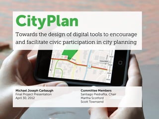
- 1. CityPlan Towards the design of digital tools to encourage and facilitate civic participation in city planning Michael Joseph Carbaugh Committee Members Final Project Presentation Santiago Piedrafita, Chair April 30, 2012 Martha Scotford Scott Townsend
- 2. FRAMING THE PROJECT Context photo credit: NCDOT
- 3. Context / Diagrams / Investigations / Next Steps Main Question How can locative technology be designed to encourage citizens to hold opinions regarding proposed development changes in the urban environment?
- 4. Context / Diagrams / Investigations / Next Steps Subquestion 1 How can locative technology guide firsthand perceptions ! and experiences in areas of the city that have been identified as needing change? • What augmentation of that experience is necessary to understand a planning issue?
- 5. Context / Diagrams / Investigations / Next Steps Subquestion 1 How can locative technology guide firsthand perceptions ! and experiences in areas of the city that have been identified as needing change? • What augmentation of that experience is necessary to understand a planning issue? Subquestion 2 How can locative technology link place with substantive explanations of an issue that requires deliberation amongst the city and citizens?
- 6. Context / Diagrams / Investigations / Next Steps Subquestion 1 How can locative technology guide firsthand perceptions ! and experiences in areas of the city that have been identified as needing change? • What augmentation of that experience is necessary to understand a planning issue? Subquestion 2 How can locative technology link place with substantive explanations of an issue that requires deliberation amongst the city and citizens? Subquestion 3 How can locative technology aid citizens in visualizing the consequences of alternate planning strategies?
- 7. Context / Diagrams / Investigations / Next Steps URBAN PLANNING is inherently political and involves many stakeholders Public planning at the substate level Large emotional stakes done by and for cities, counties, towns, Visible decisions and other units of local governments. Process close at hand Citizens correctly assume they know something Large financial consequences Link to property taxes GOVERNMENT CITIZENS requires a Planning is a function of the executive branch directed by AGENCIES or CONSULTANTS Voter separation of play different Homeowner powers Executive manages planning roles Resident including Legislative funds and taxes projects Member of organizations Judicial restricts legislation Community employer URBAN PLANNERS Property owner Advisory panels Public presentations Urban Design that request community Public meetings Urban Renewal and Community Development participation that can be more Informal meetings Transportation Planning Neutral public servant complex at a Many political jurisdictions in different with different Press releases Economic Development Planning Builder of community consensus local level for one metropolitan area fields styles Web sties Growth Management, Smart Growth, and Entrepreneur Variety of districts with Sustainable Development powers and responsibilities Advocate (i.e. school districts) Environmental and Energy Planning Agent of radical change Planning for Metropolitan Regions Health Public safety who work together to continuously develop Circulation COMPREHENSIVE PLANS designed based on goals that support “The Public Interest” Provision of services and facilities Fiscal health The most basic plans prepared to guide the Economic goals development of the community. They cover the entire community and are long term. Environmental protection Redistributive goals through an ongoing PLANNING PROCESS Research Phase Clarification of Community Plan Formulation Plan Implementation Review and Revision Goals and Objectives Content and relationships generated from Contemporary Urban Planning, 9th Ed. by John M. Levy
- 8. Context / Diagrams / Investigations / Next Steps Scope of Project Growth and Development 42% increase in population 2025 predicted to be the between 2000 and 2010 fastest-growing metro area
- 9. Context / Diagrams / Investigations / Next Steps Scope of Project Growth and Development 42% increase in population 2025 predicted to be the between 2000 and 2010 fastest-growing metro area Smartphone Ownership 46% of American adults 50% of American adults in urban areas
- 10. Context / Diagrams / Investigations / Next Steps Scope of Project Growth and Development 42% increase in population 2025 predicted to be the between 2000 and 2010 fastest-growing metro area Smartphone Ownership 46% of American adults 50% of American adults in urban areas Adults between ages 25 and 34 71% own smartphones
- 11. INVESTIGATION TWO ARTICULATING THE SYSTEM e Diagrams dy. lacks engagement with is Scans marker at end of article Participates in a site visit at th with smartphone. Peace Street Corridor. Continues to engage with CityPlan at home and work. Finds CityPlan through a link on a blog post comment.
- 12. Context / Diagrams / Investigations / Next Steps System Diagrams Stakeholder Map | Digital Touchpoint Matrix | Experience Map | Citizen Journeys EXTERNAL PRIMARY SECONDARY INTERNAL CONTENT Citizens Community Organizations Planning and Development North Carolina Department of Individuals with the ability to Organizations such as CACs Department Transportation express their opinion that advocate for the best Manages many aspects of city Multi-modal agency provides interest of communities planning and development in projects and services Homeowners different fields Individuals who own a home in Employers/Businesses Wake County Government an affected community Employ citizens and contribute Information Technology Develops transit plan for all of to local economy Department Wake County Residents Manages infrastructure that People living in communities Property Owners Triangle Transit Authority supports tool affected by a planning issue Own land potentially affected Operates regional public by planning issues City Council and Boards transportation services Activists and Commissions Individuals with strong feelings News Media Capital Area Transit Discuss and vote on issues towards particular issues Publish news and opinions on Operates public transportation that relate to planning. planning issues services for the City of Raleigh Public Affairs Department Distributes information to the public about City services, policies, and procedures
- 13. Context / Diagrams / Investigations / Next Steps System Diagrams Stakeholder Map | Digital Touchpoint Matrix | Experience Map | Citizen Journeys EXTERNAL PRIMARY SECONDARY INTERNAL CONTENT Citizens Community Organizations Planning and Development North Carolina Department of Individuals with the ability to Organizations such as CACs Department Transportation express their opinion that advocate for the best Manages many aspects of city Multi-modal agency provides interest of communities planning and development in projects and services Homeowners different fields Individuals who own a home in Employers/Businesses Wake County Government an affected community Employ citizens and contribute Information Technology Develops transit plan for all of to local economy Department Wake County Residents Manages infrastructure that People living in communities Property Owners Triangle Transit Authority supports tool affected by a planning issue Own land potentially affected Operates regional public by planning issues City Council and Boards transportation services Activists and Commissions Individuals with strong feelings News Media Capital Area Transit Discuss and vote on issues towards particular issues Publish news and opinions on Operates public transportation that relate to planning. planning issues services for the City of Raleigh Public Affairs Department Distributes information to the public about City services, policies, and procedures
- 14. Context / Diagrams / Investigations / Next Steps System Diagrams Stakeholder Map | Digital Touchpoint Matrix | Experience Map | Citizen Journeys Smartphone / Feature Phone Mobile Device Laptop Desktop TOOL CAPABILITIES Text message updates • • E-mail updates • • • • Browser, app, or operat- • • • ing system notifications Upload discussion point/ • • photos via text message Upload discussion point/ • • • photos via browser or app Photograph observations • • about a site Physical site visits • Virtual site visits • • • Issue timeline • • • Access to city documents • • • Discussion platform • • • Visualize and layer • • • city information ACCESSIBILITY Public Access (ie. Library) • Prepaid or monthly • ∞* contracts available Mobility • • • Connectivity without WiFi • •* * = has limitations in some circumstances
- 15. Context / Diagrams / Investigations / Next Steps System Diagrams Stakeholder Map | Digital Touchpoint Matrix | Experience Map | Citizen Journeys Smartphone / Feature Phone Mobile Device Laptop Desktop TOOL CAPABILITIES Text message updates • • E-mail updates • • • • Browser, app, or operat- • • • ing system notifications Upload discussion point/ • • photos via text message Upload discussion point/ • • • photos via browser or app Photograph observations • • about a site Physical site visits • Virtual site visits • • • Issue timeline • • • Access to city documents • • • Discussion platform • • • Visualize and layer • • • city information ACCESSIBILITY Public Access (ie. Library) • Prepaid or monthly • ∞* contracts available Mobility • • • Connectivity without WiFi • •* * = has limitations in some circumstances
- 16. Context / Diagrams / Investigations / Next Steps System Diagrams Stakeholder Map | Digital Touchpoint Matrix | Experience Map | Citizen Journeys Awareness Initiation Information Measured Action Results external sources influence knowledge Site visit City plans and data Opinions and concerns Citizen holds a position for the current situation Next steps discussed; nonlinear may return to Become aware through Transition from another step media channels and media to tool in the process discussion Discussion Outside action may be needed Location-based Response to city Reflection, consideration, response information and response nonlinear nonlinear
- 17. Context / Diagrams / Investigations / Next Steps System Diagrams Stakeholder Map | Digital Touchpoint Matrix | Experience Map | Citizen Journeys Awareness Initiation Information Measured Action Results external sources influence knowledge Site visit City plans and data Opinions and concerns Citizen holds a position for the current situation Next steps discussed; nonlinear may return to Become aware through Transition from another step media channels and media to tool in the process discussion Discussion Outside action may be needed Location-based Response to city Reflection, consideration, response information and response nonlinear nonlinear AWARENESS INITIATION DELIBERATION MEASURED ACTION RESULTS
- 18. Context / Diagrams / Investigations / Next Steps System Diagrams Stakeholder Map | Digital Touchpoint Matrix | Experience Map | Citizen Journeys Touchpoint Physical site touchpoint AWARENESS INITIATION DELIBERATION MEASURED ACTION AWARENESS/ DELIBERATION MEASURED ACTION INITIATION
- 19. Context / Diagrams / Investigations / Next Steps System Diagrams Stakeholder Map | Digital Touchpoint Matrix | Experience Map | Citizen Journeys Touchpoint Physical site touchpoint AWARENESS INITIATION DELIBERATION MEASURED ACTION AWARENESS/ DELIBERATION MEASURED ACTION INITIATION SETTING OF SETTING OF INVESTIGATION ONE INVESTIGATION TWO Reads article about the Peace Stree Corridor Visioning Study. lacks engagement with issue Scans marker at end of article Participates in a site visit at the with smartphone. Peace Street Corridor. Continues to engage with CityPlan at home and work.
- 20. INVESTIGATION ONE Initial Engagement
- 21. Peace St. Corridor Visioning Study Set up a Site Visit!
- 22. INVESTIGATION TWO Augmenting Physical Sites
- 34. INVESTIGATION FOUR Visualizing Planning Information
- 42. Context / Diagrams / Investigations / Next Steps Next Steps Findings | Next Steps • Civic services can be flexible, easy to use, and engaging for citizens. • Designing for location-based technologies requires consideration of everyday life. • Interactive maps can address challenges present in static visualizations of planning information.
- 43. Context / Diagrams / Investigations / Next Steps Next Steps Findings | Next Steps • Develop an interactive mapping prototype. • Consider how other forms of citizen participation could be introduced in CityPlan. • Engage with civic-minded individuals and organizations.
- 44. Thank you. Michael Joseph Carbaugh Master of Graphic Design Candidate ‘12 North Carolina State University