New Map Shows Location of Marcellus Shale in Western Maryland
•
1 like•1,245 views

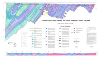
This geologic map summarizes the rock formations in Garrett, Allegany, and western Washington Counties in Maryland. It includes a description of the major rock units depicted on the map, ranging in age from Quaternary alluvium to Cambrian and older strata. The map was compiled from 16 different sources, including previous geologic mapping from the Maryland Geological Survey and the US Geological Survey.

Recommended
More Related Content
Similar to New Map Shows Location of Marcellus Shale in Western Maryland
Similar to New Map Shows Location of Marcellus Shale in Western Maryland (20)
More from Marcellus Drilling News
More from Marcellus Drilling News (20)
Recently uploaded
Recently uploaded (20)
New Map Shows Location of Marcellus Shale in Western Maryland
- 1. Garrett, Allegany, and western Washington Counties Geologic Map Geologic Map of Garrett, Allegany, and western Washington Counties, Maryland David K. Brezinski and Robert Conkwright 2013 0 5 10 miles Description of Map Units Geologic Map Compilation Sources Juniata Formation Alluvium Oriskany F ormation Rockwell Formation Interbedded, reddish brown to br ownish red, fine- to medium-grained, 2 Unconsolidated reddish b rown to tan, sand, silt, pebb les and cobbles that Interbedded, medium to dark gray, siliceous shale and sandy and cherty Oj 14 10 7 4 2 1 Interbedded, gray, s ilty shale, light gray to tan sandstone, and coaly and medium- to th ick-bedded, cross-bedded sands tone and micaceous 16 15 13 13 8 3 Quaternary Qal weathers yellow, orange, and orange -brown. Mapped alluvium de posits include MDr reddish shale. In Allegany and Washington counties a reddish brown to Do limestone near the base (Shriver Shale M ember); overlain by tan fine-grained, siltstone and silty shale. The Juniata Formation is up to 300 f eet thick those formed along mod ern and ancient streams, and marsh depos its formed calcareous sandstone ; and then by light gray, medium- to coa rse-grained, thin- gray, polymictic diamictite marks the base of the formation. The in western Allegany County (90 m). over older bog deposits. to thick-bedded, calcareous sandstone a t the top (Ridgely Member). The Ordovician 8 6 5 2 Rockwell Formation is more than 400 feet thick in west ern Washingt on 16 17 16 15 12 9 1 County; thins to less than 100 fee t in southern Garrett County ( 30-120 Oriskany Formation is approximately 50 feet thick in western Washington m). County and thicken s westward into Allegany Count y where it is up to 30 0 feet Martinsburg Shale thick (15-90 m). Medium to dark gray, fissi le shale at the base, o verlain by medium Dunkard Formation Om 17 17 17 15 gray, silty shale and thinly interbedded medium-grained sandstone; and 11 Permian? Interbedded, me dium gray t o dark gr ay, carbonaceou s, silty shale an d siltstone; then by thick-bedded, medium-grained, fining- upward s andstone at the Pd light to medium gray, micaceous, medium- to coars e-grained sandstone; and Hampsh ire Form ation top of the for mation. The Martinsburg is up to 5,000 feet thick in the thin, discontinuous nodular limestone, and thin coal beds. The Dunkard Dh Keyser-Helderberg Form ations (undivided) 18 17 17 Interbedded, reddish brown to brownish red, locally greenish gray Washington County (1 ,500 m). Formation cap s several hills in the Geo rges Creek S yncline, and may be as The Keyser Limestone consists of light gray, coarsely crystalline crinoidal sandstone, reddi sh brown si ltstone, shale, and rooted claystone. The much as 250 feet (76 m) thick. DSkh limestone in the lower 50 feet (15 m), becoming, medium to dark gray, medium- thickness of the Hampshire va ries from approximately 2,000 f eet in to thick-bedded, nodular, fossiliferous li mestone containing dark gray chert 18 Garrett County to mor e than 3,000 f eet in eastern Alleg any and western Washington counties (600-900m). nodules. The upper Keyser is thin-bedded, che rty, fossiliferous limestone. The Cambrian and Older Cambrian and Ordovician strata Keyser is up to 300 feet thick in western Washington County and thins to Illustrated in cross-section only. Monongahela Group approximately 200 feet in thickness in western Allegany County (60-90 m). Ordovician C-O 1. Clear Spring and Hedgesville quadrangles (Maryland part). Mapping by D.K. Brezinski and J.D. Interbedded, me dium gray t o dark gr ay, carbonaceou s, silty shale an d siltstone; The Helderberg Limestone cons ists of medium gray, medium-bedded, c herty, Pm Glaser. Explanation of Map Symbols light to medium gray, micaceous, medium- to coarse-grained sandstone, and Foreknobs Formation crinoidal limestone (New Creek M ember); overlain in western Washington 2. Geologic Map of Portions of the Hancock, Cherry Run, and Big Pool quadrangles, Washington County, thin, discontinuous, nodular li mestone, and coal beds. The thicknes s of the County by a light gr ay, cross-bedded calcareous sandstone (Elbow Ridge Maryland. J .D. Glaser, 2 003, Maryland Ge ological Survey digit al geological map, scale 1:24,000. Field Df Interbedded, olive-gray medium- to coarse-grained, cross-bedded Monongahela Group is 225 to 250 f eet (68 to 76 m) . Sandstone ); then a medium-gray fossiliferous limestone containing beds of checked and modified by D.K. Brezi nski 2012. sandstone; greenish gray to dusky red, fos siliferous shale and siltstone. Contacts Thick (>30 feet, 10m) s andstone int ervals occur both nea r the bas e and brown-weathering chert (Corriganvi lle Limestone); which is succeeded by 3. Geologic map of the Bellegrove Quadrangle, Allegany and Washington counties, Maryland. J.D. near the top of the f ormation. The Foreknobs ranges f rom 1,200 feet interbedded, c herty, dark-gray limestone, and dark calcareo us shale (Licking Glaser, 1994, Maryland Geological Survey Open-File Geologic Map, scale 1:24,000. Fi eld checked thick in Garrett County to more then 1, 500 feet in thickness in easter n Creek Member) ; and topped by a thin, black, brittle shale (Mandata Shale). The and modifi ed by D .K. Brezinski, 2 012. Geologic contacts; approximately located Conemaugh Group (Undivided) Helderberg Limestone is 150 to 180 feet thick in western Maryland (30-55 m). 4. Geologic ma p of the Artemas Quad rangle, Allegany County, Maryland. J.D. Glaser, 1 994, Maryland Interbedded, light gray, micaceous sandstone and gray silty shale a nd thin, dark Allegany County (365-460 m). dotted where concealed Pc Geological Survey Open-File Geological Map, scale 1:24,000. Field chec ked and modified by D.K. gray, marine shales in the lower half of the group, and greenish-gray and Brezinski, 2012. reddish brown to va riegated mudstone, sh ale, claystone, and nodu lar nonmarine 5. Geologic map of the PawPaw Quadrangle, Allegan y County, Maryland. J.D. Glaser, 19 94, Maryland limestone in its upper part. The Conemaugh Group is 800 to 900 feet thick (245 Tonoloway Form ation Geological Survey Open-File Geological Map, scale 1:24,000, field checked and m odified by D.K. to 275 m) . Harrell-Brallier-Sherr Formations (undivided) Brezinski, 1999. Pennsylvanian Dhbs The Harrell Shale is a dark gray, fissile, calcareous, thinly laminated, Sto Medium to light gray, fine-grained, thinly laminated, mudcracked, dolomit ic 6. Geologic map o f the Oldtown Quad rangle, Allegany County, Maryland. J.D. Glaser, 1994, Maryland U High angle Fault-U upthrown block shale that w eathers to thin yellowish gray s hale chips. The base of the limestone with thin layers of medium gray, fine-grained limestone, and tan, D-downthrown block dotted where Geological Survey Open-File Geological Map, scale 1:24,000. Field chec ked and modified by D.K. D Harrell is marked by the black, ve ry fissile Burket Shale Member. The laminated dolomite. The Tonoloway Limestone is approximat ely 400 feet thick concealed Brezinski, 2012. Harrell grades eastward into the Brallier Formation. The Harrell Shale (120 m ). All egh en y Formation 7. Geologic ma p of the F lintstone Quadran gle, Allegany County, M aryland. J.D. Gla ser, 1994, Maryl and is up to 150 feet thick (45m). Geological Survey Open-File Geological Map, scale 1:24,000. Field chec ked and modified by D.K. Pa Interbedded, medium to da rk gray shale and siltstone, tan to li ght gray sandstone, claystone, and mineable coal beds. The Allegheny Formation is The Brallier Formation is a success ion of thinly interbedded, gray to Brezinski, 2012. between 200 t o 250 feet thick (61 to 76 m) . olive-gray shale and siltstone and thin, fine-grained sandstone. The 8. Bedrock Geology of the Evitts Creek and Pa tterson Creek Quadrangles Maryl and, Pennsylvania, and Devonian Brallier is 2,000 to 2,500 feet thick (600-760 m) . Wills Creek Formation West Virginia, W, de Witt and G.W. Colton, 1964, US Geological Survey Bulletin 1173. Swc Interbedded, greenish gray to light gray, calcareous shale, and tan, dolomitic Thrust fault- triangles point to The Sherr For mation is interbedde d, reddish-brown to grayish brown DEPARTMENT OF NATURAL RESOURCES 9. Geology of the Cresaptown quadrangle, Allegany County, Maryland. J.D. Glaser, 1994, Maryland upthrown block shale; thin, gray siltstone; and fine-grained, bioturbated and fossiliferous shale containing mud crac ks, laminations, and salt and gypsum casts. The Geological Survey Open-File Geological Map, scale 1:24,000. thickness of the Wills Creek is approxima tely 400 feet (120 m). John R. Griffin sandstone. The thickness of the Sherr i s approximately 1,000 feet in 10. Geologic Map of th e Cumberland quadrangle, Allegany C ounty, Maryland. J.D. Glaser and D.K. Pottsville Formation Secretary Brezinski, 1994, Maryland Ge ological Survey Open-File Geological Map, scale 1:24,000. Modified by Dominantly light gray to tan, medium- to coarse-grained s andstone and Garrett County and becomes indistinct in eastern Allegany and western Pp D.K. B rezinski, 2012. conglomerate with subordinate amounts of dark gray shale, siltstone, and coal. Washington counties (300 m). A’ Joseph P. Gill 11. Geology of the Keyser Quadrangle, J.M. Dennison, 1963. West Virginia Geologic Quadrangle Maps Total thickness for the unit is 180 to 200 feet (55 to 61 m). Silurian Mckenzie - Bloomsburg Form ations (undivided) Deputy Secretary GM 1, scale 1:24,000. Sb Cross section line Smb Interbedded, greenish gray, calcareous shale and medium to da rk gray, thinly 12. Geologic map of the Lonaconing Quadrangle, Allegany and Garrett counties, Maryland, J.D. Glaser and Sm bedded, foss iliferous limestone (Sm McKenzie Formation); overlain by D.K. Brezinski, 1998, Maryland Geological Survey Open-File Geologic Map, scale 1:24,000. Mahantango Formation Dm interbedded, r eddish gray to brownish gray, fine-grained sandstone an d hackly 13. Geologic map of the Avilton and Fr ostburg quadrangles, Allegan y and Garrett counties, Marylan d, A Mauch Chunk Formation Medium gray to olive-gray, massive siltstone to fine-grained sandstone shale to mudrock (Sb Bloomsburg Form ation). The M cKenzie Formation is up D.K. Brezinski, 1989, Maryland Geological Survey, scale 1:24,000. Mmc Interbedded, reddish brown shale; variegated, root-mottled mudstone and near the base and top of the formation; interbedde d with these siltstone to 300 feet thick ( 90 m), and the Bloomsburg Formation rar ely exceeds 100 feet 14. Coal Geology of the Castleman coal field, Garrett County, Maryland. P.C.Lyons, E.F. Jacobsen, and siltstone, and reddish brown to greenish gray lenticular sandstone. The Mauch intervals are thinly interbedded s iltstone, sandstone, and silty, ha ckly B.K. Scott, 1985, US Geological Survey Coal Investigations Map C-98. shale. W eathers brownish gr ay to grayis h brown. The Mahantango (30 cm) in thickness. Base Map Symbols Chunk Formation i s approximately 60 0 feet thick in Allega ny County and thins 15. Unpublished Geologic Mapping o f the Barton a nd Westernport Quadrangles, D.K. Brezins ki. 1988- westward to 300 feet in thickness in western Garrett County (90 -180 m). Formation is approximately 1,400 feet thick in A llegany County and 1999. thins westward to less than 1,000 feet in thickness in the subsurface of 16. Coal Geology of the Lower Youghiogheny coal field, Garrett County, Maryland. E.F. J acobsen and Garrett County (300-425 m) . P.C.Lyons, 1985, US Ge ological Survey Coal Investigations Ma p C-101. Modified by D.K. Brezinski , 68 Interstate Highway Sk Rose Hill-Keefer Formations (undivided) MARYLAND GEOLOGICAL SURVEY 2012. The Rose Hill Formation (Sr) consists of pale olive-gray to pale reddish gray, Jeffrey Halka Greenbrie r For mation Srk 17. Unpublished geologic mapping of the Deer Park, Gorman, Kitzmiller, McHenry, Oakland , Sang Run Sr fissile shale. Shales are loc ally interbedded with fine-grained, thinly laminated Director 40 U.S. Highway Mg Light gray, cross-bedded, s andy limestone to calcareous sandstone at the base and Ac cident quadrangles, D.K. Brezinski. 1997-1999. Needmore -Marcellus Shales to cross-laminated sandstone . The Rose Hill is overlain b y the Keefer 18. Geology of the Davis and T able Rock quadrangles in Maryland. D. K. Brezinski a nd J.D. Glaser 20 02, Map Location 615 State Numbered Highway (Loyalhanna Member); overl ain by interbedded, reddish, fossilife rous mudstone, and tan to reddish brown, fine-grained sandstone , and reddish brown Dnm The Needmore Shale is a dark-brownish-gray to medium-dark gray, Sandstone (Sk), a light gray to tan, fine to medium-grained, thin- to medium- Maryland Geological Survey D igital Geologic ma p, scale 1 :24,000. calcare ous, fossiliferous shale, with thin (1 foot, 30 cm) beds of dark bedded, biotur bated sandstone, that is mapped separa tely in eastern Allegany siltstone and variegat ed s hale (Savage D am Member); succ eeded by thin- to and western Washington counties. The approximate thickness of the Rose Hill Mississippian medium-bedded, light to medium gray, argillaceous, fossiliferous limestone at gray, argillaceous limestone . The upper Needmore Shale consis ts of approximately 35 f eet (10 m) of interbed ded, dark gra y, argillaceous Formation and Keefer Formation combi ned is 300 feet (90 m). Stream the top (Wymps G ap Member). The Greenbrier Formation is 150 to 200 f eet thick (45-60 m). limestone and black shale. This interval is correlative with the Water body Onondaga Limestone of New York. The top of the Needmore Shale is (eg. lakes, ponds, rivers) marked by the Tioga Bentonite, a bro wn, tuffaceous cla ystone. The Needmore Shale is 150 feet thick in Allegany County (45 m). Tusca rora Sands tone Map available as printable version and GIS The Marcellus Shale consists of black, brittle, fissile shale i n the lower St Light-gray, fine- to medium-grained, medium-bedded, dense sandstone. STATE OF MARYLAND coverage from the Maryland Purslane Formation Locally, sandstone layers are interbedded with thin, gray shale . The thickness Martin O’Malley Mp 100 feet (30 m); interbedded, t hinly bedded, black limestone and sha le Geological Survey website Light gray, tan, and red dish brown, coarse-grained to conglomeratic , thick- of the Tuscarora Sandstone varies from less than 50 feet in Wa shington County Governor in the middle ; and very dark g ray, fissile s hale co ntaining thin ( 0.5-1 http://www.mgs.md.gov/ bedded to c ross-bedded sandstone and thin beds of gray shale, and coaly shale. to up to 380 f eet in w estern Allegany C ounty (15-115 m). Version:WMD2013.1.0 The Purslane is more tha n 300 feet thick in w estern Washing ton County and inch, 1-2 cm) siltstone beds at the top. The Marcellus Shale is more the thins westward to approximately 150 feet thick in western Garrett County (45- 350 feet thic k in western Washington Co unty and thins to approximately Anthony G. Brown 90 m). 150 feet in the subsurface at Keysers Ridge (45-105 m). Lieutenant Governor Interpretive Geologic Cross Section for A – A’