VALIDATION CERTIFICATE of “4D GeoSEIS Tomography” Method for 3D-4D transformation of 2D images

World-first discovery of 4D GeoSEIS Tomography Method can help save cost for oil-gas & ore deposit`s prospecting. * We propose for any company 3D-4D GeoSEIS Tomography transformations of airborne thermal & multispectral satellite images, geophysical data (magnetic, gravity, IP, seismic) and DEM to multifactor volumetric 3D-4D GeoSEIS (space-time) model, exact ranging and forecasting of mineral deposits, multifactor volumetric mapping of low-amplitude tectonics, geophysical anomalies and geologic properties of deep structures for cost-effective geological prospecting: http://www.flickr.com/photos/jeisus2012/sets/72157626153283579/with/5559736588/ ; * We have used multispectral images of WorldView-2 satellite with 1-2 meter resolution for volumetric 3D GeoSEIS mineral potential mapping (deep: 500-1500m) with much higher resolution (1-2m) than 3D seismic, magneto-telluric, electromagnetic data before drilling. * We have used geophysical data & multispectral images of Landsat 5-7, ASTER, Hyperion satellites with 15-30 meter resolution for volumetric 3D GeoSEIS mapping of geological formation & tectonic structures up to depth 19-60km: http://www.flickr.com/photos/jeisus2012/5559736588/in/set-72157626153283579 . The application of the 4D GeoSEIS Tomography for transformations 2D-3D images of spectral brightness fields and geophysical fields into volumetric 3D-4D GeoSEIS (space-time) models proved to be an effective low-cost exploration tool: During 22 years the great number of prospectivity maps, volumetric structural-geodynamic, geological and geophysical models of ore (Fe-Ti, Cu, Au, Hg, Ni-Cu-Co) and oil-gas deposits (DR Congo, Namibia, Kalimantan, Urals, Ukraine, Timor, Uzbekistan) are created: http://www.flickr.com/photos/jeisus2012/sets/72157626153283579/ ; http://www.flickr.com/photos/jeisus2012/sets/72157626153052573/ ; http://foto.mail.ru/mail/jeisus/4DGeoSEISTomography; http://foto.mail.ru/mail/jeisus/7 . We have used 4D GeoSEIS software for processing of the ASTER, Landsat7ETM and aeromagnetic images to create the volumetric 3D-4D GeoSEIS Models (Depth: 0-17кm) of the NW Namibia & SE Angola territory (http://foto.mail.ru/mail/jeisus/7/35.html# ) to discriminate the high potential concentration of mineral resources based on limited field data in order to aid exploration for new copper and titaniferous magnetite mineralization : http://www.flickr.com/photos/jeisus2012/4616967080/in/set-72157626153283579/ . Using 4D GeoSEIS software for multifactor volumetric structural-geodynamic, geophysical, geochemical and mineralogical modeling we offer: * Integration of the mineralogical, geochemical and geophysical data, DEM and multispectral satellite images (Hyperion, ASTER, LANDSAT-7ETM and others) in multifactor volumetric 3D-4D GeoSEIS Model. * Volumetric 3D-4D GeoSEIS models which will allow to increase accuracy of tectonic structures mapping on deep horizons to a level of near-surface horizons…

Recomendados
Recomendados
Mais conteúdo relacionado
Último
Último (20)
Destaque
Destaque (20)
VALIDATION CERTIFICATE of “4D GeoSEIS Tomography” Method for 3D-4D transformation of 2D images
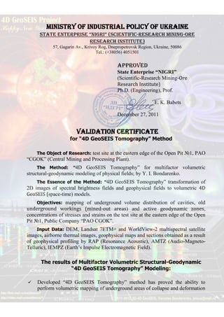
- 1. MINISTRY of INDUSTRIAL POLICY of UKRAINE State Enterprise “NIGRI” (Scientific-Research Mining-Ore Research Institute) 57, Gagarin Av., Krivoy Rog, Dnepropetrovsk Region, Ukraine, 50086 Tel.: (+38056) 4051501 APPROVED State Enterprise “NIGRI” (Scientific-Research Mining-Ore Research Institute) Ph.D. (Engineering), Prof. ______________E. K. Babets December 27, 2011 VALIDATION CERTIFICATE for “4D GeoSEIS Tomography” Method The Object of Research: test site at the eastern edge of the Open Pit №1, PAO “CGOK” (Central Mining and Processing Plant). The Method: “4D GeoSEIS Tomography” for multifactor volumetric structural-geodynamic modeling of physical fields; by Y. I. Bondarenko. The Essence of the Method: “4D GeoSEIS Tomography” transformation of 2D images of spectral brightness fields and geophysical fields to volumetric 4D GeoSEIS (space-time) models. Objectives: mapping of underground volume distribution of cavities, old underground workings (mined-out areas) and active geodynamic zones, concentrations of stresses and strains on the test site at the eastern edge of the Open Pit №1, Public Company “PAO CGOK”. Input Data: DEM, Landsat 7ETM+ and WorldView-2 multispectral satellite images, airborne thermal images, geophysical maps and sections obtained as a result of geophysical profiling by RAP (Resonance Acoustic), AMTZ (Audio-Magneto- Telluric), IEMPZ (Earth’s Impulse Electromagnetic Field). The results of Multifactor Volumetric Structural-Geodynamic “4D GeoSEIS Tomography” Modeling: Developed “4D GeoSEIS Tomography” method has proved the ability to perform volumetric mapping of underground areas of collapse and deformation
- 2. associated with the local thermo-elastic stress fields around mined-out areas at depths of 0-600m. Subsurface maxima of spectral brightness fields, which are associated with the environmental heating and rock breakage (caving) zones above old mine workings and below areas of active crater formation, have been mapped on the orthogonal slices of the volumetric 4D GeoSEIS model. The anomalies of spectral brightness measured by the airborne thermal imager and the infrared sensors World View-2, which have been recalculated with regard to depth, have enabled accurate mapping of cavities, old underground workings (mined-out areas) and active geodynamic zones available in geologic environment. Comparison of the vertical sections of volumetric 4D GeoSEIS model of spectral brightness in 860-1040nm range (World View-2) with vertical geophysical sections obtained with AMTZ and RAP profiling, the results of drilling and geo- surveying details of old underground mining at the test site area of the Open Pit №1, (PAO CGOK) has shown the following: 1) Around most old underground workings (mined-out areas), fields of thermo-elastic expansion of the geological environment were created, and they are visualized on the vertical sections of volumetric 4D GeoSEIS model as anomalies of maximum spectral brightness; 2) The structure of field of thermo-elastic expansion over mined-out area has a regular pattern - most vertical chains of local anomalies are located over pillars or between excavations at various levels. This peculiarity in distribution of anomalies is easy to explain by the processes of rock collapse and upward flow of cavities. 3) The structure of the field of thermo-elastic expansion of the geological environment over mined-out areas (anomalous for its spectral brightness) can serve to identify the trajectory of upward “cavities” flow. 4) The intervals and locations of the points, where drilling tools sink down, are notable for anomalies of maximum spectral brightness. The locations and intervals between places of drilling fluid loss coincide with aquifer zones, which are registered due to anomalies of minimum spectral brightness. 5) The high-gradient levels of the acoustic field (RAP) conformally fit into the structure of spectral brightness gradient field. Two major anomalies of the acoustic field correlate well with anomalies of spectral brightness minima in high- humidity areas, while the other two anomalies coincide with anomalies of spectral brightness maxima in the areas of upward “cavities” flow - highly porous zones of environment deconsolidation. 6) Locations of all AMTZ anomalies at 100m-150m depths coincide with the local anomalies of maximum spectral brightness. The latter offer more accurate reflection of the morphology of the echelon fracture zones associated with horizontal left-hand shear zone.
- 3. Evaluation of information value of the transformed fields of spectral brightness in thermal and near-infrared spectrum regions for deep detection of old underground workings (mined-out areas) at the test section has shown that with mined-out areas being 191233c.u., the areas of detected mine workings have made 150265c.u. and 149558c.u., respectively; the accuracy of detection of old underground workings based on thermal field anomalies has been 78.5% and based on anomalies of spectral brightness in near-infrared spectrum band - 74.2%. From analysis of the obtained results, the following conclusions can be drawn: The “4D GeoSEIS Tomography” methods developed for multifactor volumetric structural-geodynamic modeling can serve for accurate mapping of the low-amplitude tectonic structures (lineaments, fractures, shear zones, folds, faults), active geodynamic zones, cavities, old underground workings (mined-out areas) and crater-formation zones. Vertical sections of volumetric “4D GeoSEIS Tomography” (space-time) models of spectral brightness fields of airborne and satellite images are in good agreement with geological and geophysical sections, leaving behind other methods in detection of the locations of cavities and old underground workings (mined- out areas) at different depths. The obtained results allow the amount of expensive geophysical surveys and drilling of deep wells to be significantly reduced in the process of further exploration and exploitation of the Gleevatsky open pit of PAO "CGOK". We consider it advisable to further conduct research and methodological work on approbation and improvement of the “4D GeoSEIS Tomography” methods of multifactor volumetric structural-geodynamic modeling and forecasting of small- amplitude tectonic structures, fields of strains and stresses, cavities, old underground workings (mined-out areas) within the total area of the Gleevatsky open pit of PAO "CGOK". We consider it worthwhile to further perform scientific research and experimental-methodical work on integration of engineering-geological, geophysical and geodetic models in multifactor volumetric 4D GeoSEIS model. The results of the multifactor volumetric 4D GeoSEIS modeling within Gleevatsky open pit of PAO "CGOK" enable us to recommend that designing agencies, exploration and mining companies should use “4D GeoSEIS Tomography” method for multifactor volumetric modeling, forecasting and monitoring hazardous geodynamic processes, distribution of cavities, old underground workings (mined-out areas) and their related zones of crater formation. Head of Scientific and Technical Department Ph.D. A.A. Sova