
Recomendados
Mais conteúdo relacionado
Destaque
Destaque (19)
Último
Último (20)
History of Przedmiescie Odrzańskie - Nadodrze
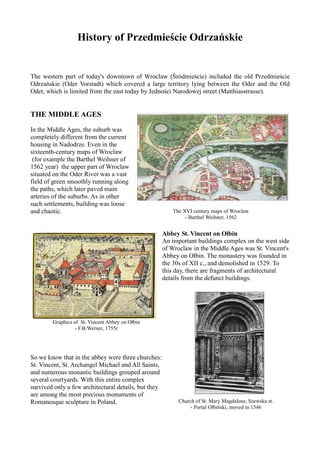
- 1. History of Przedmieście Odrzańskie The western part of today's downtown of Wroclaw (Śródmieście) included the old Przedmieście Odrzańskie (Oder Vorstadt) which covered a large territory lying between the Oder and the Old Oder, which is limited from the east today by Jedności Narodowej street (Matthiasstrasse). THE MIDDLE AGES In the Middle Ages, the suburb was completely different from the current housing in Nadodrze. Even in the sixteenth-century maps of Wroclaw (for example the Barthel Weihner of 1562 year) the upper part of Wroclaw situated on the Oder River was a vast field of green smoothly running along the paths, which later paved main arteries of the suburbs. As in other such settlements, building was loose and chaotic. The XVI century maps of Wroclaw - Barthel Weihner, 1562 Abbey St. Vincent on Ołbin An important buildings complex on the west side of Wroclaw in the Middle Ages was St. Vincent's Abbey on Ołbin. The monastery was founded in the 30s of XII c., and demolished in 1529. To this day, there are fragments of architectural details from the defunct buildings. Graphics of St. Vincent Abbey on Ołbin - F.B.Werner, 1755r So we know that in the abbey were three churches: St. Vincent, St. Archangel Michael and All Saints, and numerous monastic buildings grouped around several courtyards. With this entire complex survived only a few architectural details, but they are among the most precious monuments of Romanesque sculpture in Poland. Church of St. Mary Magdalene, Szewska st. - Portal Ołbiński, moved in 1546
- 2. CON CONSTRUCTION OF FORTIFICATIONS in the middle of XVIII c. A breakthrough in the spatial layout of the suburbs occurred only in the eighteenth century. Then the Prussian King Frederick the Great changed the layout of land, thrusting a little wedge of fortifications at the beginning what is today called Sienkiewicza Street, exposing the gate and bastion of the “Star returned to the north”. At the end of this century the first non-durable workshops started to work too. Soon around the today’s Dubois street and Cybulskiego street, appeared bonded of carbon and salt, but actually Plan of Wroclaw with visible fortifications – 1800 the industrial side of suburb developed in the next century. DEMOLITION OF FORTIFICATIONS - DEVELOPMENT OF THE SUBURBS - the beginning of the XIX. c. In the early nineteenth century, almost all the buildings of Przedmieście Odrzańskie had been burned. In 1806 the town was severely damaged. At the turn of 1806 and 1807 years the Prussian garrison burned buildings of suburbs, in order to destroy the refuge for besieging the city Napoleon's troops. Fire in the suburbs in front of The Odrzańska Gate A turning point for the town planning of the city was ordered in 1807 by Prince Jerome Bonaparte, commander of French troops occupying the city. This called for the demolition of the town’s fortifications. The decision of the Emperor Napoleon I's brother helped to expand the boundaries of Wroclaw and include five suburbs: Przedmieście Mikołajskie, Świdnickie, Oławskie, Piaskowe and Odrzańskie. After connecting the suburbs area of Wroclaw , the area increased almost sixteenfold (from 133 to 2046 ha). Plan of Wroclaw after the destruction of the city walls - Formally, suburbs in Wroclaw were merged with around 1807 the city on November 19th 1808, but, in fact, that process was longer.
- 3. A slow expansion of the suburbs began after the destruction of the fortifications, while still retaining their half-rustic character, a small number of buildings were non-paved and surrounded by wooden fences streets. On the map of Wroclaw in 1843, we can see the outline of today's main downtowns streets. It was a time of development for new factories (chicory, brewing alum, labels, buttons, mirrors, glass, soda water) and commercial centers located on the street. Houses on Jedności Narowowej st. CONSTRUCTION OF RAILWAYS The development of Wrocławs's suburbs accelerated the introduction of railways to the city in 1842. Nadodrze Railway Station - Main Railway Station to covering the needs of the local and national population. Nadodrze Railway Station Narrow-gauge railway station at Staszica square Unfortunately, the expansion of Wroclaw suburbs proceeded rapidly and sometimes haphazardly. Especially in Przedmieście Odrzańskie and Oławskie with its chaotically distributed architecture of tenement houses, which led to intense, faulty building, and decidedly poor housing conditions. There was overpopulation, crowding, lack of sunlight and sanitation. In addition to new buildings, on these sites mainly semi-rural houses covered with straw were built. August Semrau called the district the ghetto of porters, carpenters and laundressses. In the second half of the century began the construction of big houses on the Trzebnicki square, Łokietka street, Pomorska street, Obrońców Pokoju street, featuring a giant human crowds. Closer to the city center, the area was maintained in much better condition. Further, however, even in 1850 the area of present Nadodrze looked more like bottomless puddle rather than a residential city street. View on Dubois st.
- 4. Even worse are the present side streets, where the majority of Naododrze’s poorest live. In 1850 it was written that in times of rainfall, there is a suburb the is best avoided. Sais suburb was also impaired in terms of public utility, and there were no developments plans for whole neighbourhoods. The municipality tried to keep most of the streets an appropriate width and to leave open spaces for squares. They operated in the maintenance of adequate roads, provision of water supply, etc. But with regard to the roads, there was still much to be desired. DEVELOPMENT IN THE 70s. of XIX c. After 1871, an unprecedented construction boom took place in Wroclaw. It was caused by political events (Frankfurt Peace concluded between Prussia and France in 1871 and ended the war between the two countries), numerous legislative changes and new economic measures in Germany, and the rapid repayment of contributions imposed on France - 5 billion francs in gold. Further development of housing on Przedmieście Odrzańskie was possible in 1873 - Guido von Drabitziusa and Otto Bauers created the conception of land management on the field of St. Matthias. St. Matthias square After 1877 there was a clear decrease in the number of construction projects undertaken, which caused the stock market crash of 1873. Hostilities of the 20th century had a mild affect around the Nadodrze train station. Today, the majority of buildings date from the years 1860-1880, which have a characteristic form, usually known tenement houses. According to original text: Marta Swoboda, Dzieje wrocławskiego Przedmieścia Odrzańskiego www.skarbykultury.pl Translated and supplemented: Infopunkt Nadodrze - Łokietka5 Anna Siemieniec