Preconsolidation in glacial sediments: the case of Andorra
•
1 gostou•407 visualizações

QRA (Quaternary Research Association) 2017 Annual Discussion Meeting

Recomendados
Recomendados
Mais conteúdo relacionado
Semelhante a Preconsolidation in glacial sediments: the case of Andorra
Semelhante a Preconsolidation in glacial sediments: the case of Andorra (20)
Mais de Fundació Marcel Chevalier
Mais de Fundació Marcel Chevalier (20)
Último
Último (20)
Preconsolidation in glacial sediments: the case of Andorra
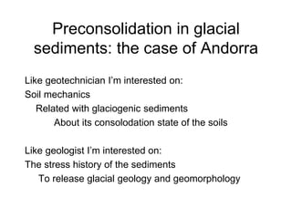
- 1. Preconsolidation in glacial sediments: the case of Andorra Like geotechnician I’m interested on: Soil mechanics Related with glaciogenic sediments About its consolodation state of the soils Like geologist I’m interested on: The stress history of the sediments To release glacial geology and geomorphology
- 2. Preconsolidation in glacial sediments: The case of Andorra • Introduction to the last glacial cycle in Andorra • Cases of study – Case 1 : Soil mechanics in the lateral moraine • Case 1 servers to introduce into case 2 – Case 2 : Soil mechanics of the overdeepened valley infill • Major question marks
- 3. The largest glacial extention (MIS 3) Pont Trencat Andorra La Massana Ordino Os de Civis Pal Erts Arinsal Madriu Claror Perafita Els Cortals Ari¸ge Canillo Encamp Escaldes Engolasters Grau Roig Incles Arcalis Rialb Sorteny Angonella St Juliˆ de Lˆria Ransol Juclar Siscar— St Josep Montaup Soldeu Vall del Riu Cosmogenic 21Ne 59.100 ± 5.170 Ka AND 6 Fontargente Cerdanya 43 Km SPAIN France ANDORRA
- 4. Widespreat retreat of the glaciers in the MIS 2 onset < 13 Km Balma Margineda C10 13.763±257 cal BP (875 m) El Forn 13.380±380 cal BP -124014 (1540 m) El Cedre (Charred material) 13.585±275 calBP (875 m) Glaciofluvial
- 5. Glacier advance: Main subglacial till deposition on H3 Conflu¸ncia Front a Sant Juliˆde Lˆria 32.789 ± 1.187 OSL Cal Tolse Sornˆs 23.530 ± 130 BP 28.432 ± 335 Cal BP -203440La Massana 24.770 ± 170 BP 29.803 ± 334 CalBP -115016 La Aldosa 24.350 ± 150 BP 29.109 ± 451 Cal BP -115016 Escaldes 27.010 ± 170 BP 31.770 ± 149 Cal BP -203458 37,5-35 Km Layer 3a/3b
- 6. Glacial retreat and glaciofluvial sedimentation on the main valley <20 Km Layer 2 Balma Margineda C10 13.763±257 cal BP (875 m) El Forn 13.380±380 cal BP -124014 (1540 m) El Cedre (Charred material) 13.585±275 calBP (875 m) Northern glaciers Eaestern glaciers Glaciofluvial
- 7. Glacier advance in H2 - LGM: Glaciotectonite formation 33 - 31,5 Km Layer 2a/2b La Massana Lake Sispony 20.875 ± 322 cal BP -115016 Aldosa La Margineda Entremesaigˆes AND 9 18.077±1.309 Be 10 Engolasters Els Vilars 19.824 ± 298 cal BP Canolich Landslide 18.230 - 17.390 cal BP -198808 Santa Coloma La Comella moraine Turu et al. (2016) Did Pyrenees glaciers dance to the beat of global climatic events? Evidence from the würmian sequence stratigraphy of an ice- dammed paleolake depocentre in Andorra. In: Quaternary Glaciation in the Mediterranean Mountains (P.D. Hughes & J.C. Woodward,Eds.), Geological Society of London, Special Publications. Doi:10.1144/SP433.6
- 8. Glacial retreat and again glaciofluvial sedimentation on the main valley <20 Km Layer 1 Balma Margineda C10 13.763±257 cal BP (875 m) El Forn 13.380±380 cal BP -124014 (1540 m) El Cedre (Charred material) 13.585±275 calBP (875 m) Valira del Nord glaciers Valira d’Orient glaciers Glaciofluvial
- 9. Glacier advance in H1, Glaciotectonite formation 31-29 Km Layer 1a/1b Sornˆs 14.645±355 cal BP (1300 m) ? Santa Coloma Charred material 14.645±375 cal BP (975 m-16,4 m) Andorra Rossell .. and recession
- 10. Widespread glacier retreat in the Bölling/Alleröd 13 Km Balma Margineda C10 13.763±257 cal BP (875 m) El Forn 13.380±380 cal BP -124014 (1540 m) El Cedre (Charred material) 13.585±275 calBP (875 m)
- 11. The overdeepened infill of Andorra Geomorphology of the main valley and position of the glaciers at the last glacial advance from the Upper Pleistocene CASE 1 : on the lateral moraine – La Comella CASE 2 : on the bottom of the valley – La Closa (1) fluvial network, (2) alluvial cone, (3) debris cone and scree, (4) mountain peak, (5) glacial cirques, (6) hummocks, (7) subglacial gorge, (8) morainic ridge, (9) reconstructed glacier margins, (10) till, (11) alluvium, (12) colluvium, (13) glacier front. Red circle main examples 2 1
- 12. TURU, V., BOULTON, G.S; ROS, X.; PEÑA-MONNÉ, J.LL.; MARTÍ-BONO C.; BORDONAU, J.; SERRANO-CAÑADAS, E.; SANCHO- MARCÉN, C.; CONSTANTE-ORRIOS, C.; POUS, J.; GONZÁLEZ-TRUEBA, J.J.; PALOMAR, J.; HERRERO, R. & GARCÍA-RUÍZ, J.M. (2007). “Structure des grands bassins glaciaires dans le nord de la péninsule ibérique: comparaison entre les vallées d’Andorre (Pyrénées Orientales), du Gállego (Pyrénées Centrales) et du Trueba (Chaîne Cantabrique)”; Quaternaire, 18 (4), 309-325 The overdeepened infill geophysics
- 13. Case 1: La Comella lateral moraine Image previous to the final excavation On top grounded micropiles (not visible), bounded with concrete on top
- 14. La Comella lateral moraine Final excavation fixed with projected concrete … but micropile spacing was not enough tight, and a portion of the excavated slope fail. Opportunity arise then to take a look into the supraglacial till. Moraine ridge
- 15. La Comella lateral moraine Sampled layer
- 16. La Comella lateral moraine “Tova” sample …… silts with some oxidated lenses (water seepage) Fe+ 3
- 17. La Comella lateral moraine “Dura” sample Highly compacted and shared, sandy core acting as intraclast boulder clivage
- 18. Granulometry of “Dura”sample Sands 79% - Silts 20 % - Clay 1 %
- 19. Shear box test “TOVA” sample Consolidated and Undrained (CU)
- 20. Shear box “Dura” sample Consolidated and Undrained (CU)
- 21. Oedometric tests The stress history is archived. On both samples a common preconsolidation exist (supraglacial till formation), while multiple overconsolidations are present on “Dura” sample (from a former subglacial till) 5MPa 1MPa
- 22. – Existent data • One borehole until 60 and 90 m depth has been published (Miquel et al., 2011), but is difficult to consult • Seismic reflexion profiles published (Teixidor, 2003), but is difficult to consult – MC Earth Science Foundation data • Mainly borehole observations come from the first 30 m depth • In-situ testing (pressurometer tests and SPT or other dynamic penetration proves • Pumping tests and slug tests • Seismic refraction (P and S waves) • Resistivity measurements, mostly VES soundings • Shallow Nuclear Magnetic Resonance (SNMR) Acquired geotechnical data at the main valley Main valley, view upward, at Escaldes-Engordany through the Valira d’Orient and Madriu confluence Main valley, view downward through CASE 2: Geomechanical data in the valley floor
- 23. Site outcrops across the valley
- 24. Glaciotectonite 1a/1b 1b 1a Holocene Antropogenic Underground car parking excavation in la Closa site
- 26. Massive sands and silts Striated gravels Striated gravels Laminated sands and silts Laminated sands and silts La Closa sediments Layer 3: Lodgement till
- 27. Lateral valley eskers ON NEXT SLICE
- 28. Sedimentary accretion is produced in lateral subglacial channels (eskers)
- 29. In-Situ soil testing of the shear strength: Pocket vane test The silty-sandy layer show a decreasing pattern from top to bottom. The shear strength is directly related with the apparent cohesion and thus with its consolidation state. So in the lateral sides of the glaciated valley of Andorra, former high water pressures were present Strain state on the latereal subglacial channels C s S S' S" G B0 10 20 KPa Light brown Dark brown Brown Light brown Granulometry Sandy till with deformed water tractive structures Imbricated sand and gravels. Horizontal bedding. Silt and sand with some gravel beds. Matrix supported and load casts. Silty till with boulders Till Till Till Till Till “Décollement”
- 30. G 063.06.01 Gas (Nitrogen)“Push in” with a penetrometer Controller In-Situ Soil Mechanichs: The pressuremeter device
- 31. 1 2 h + 1 2 Tests Bore-hole Shear test Oedometric test Sediment normally consolidated Pressuremeter test = Oedometric + Shear test Po Po’ IN SITU geotechnical data
- 32. Borehole data and preconsolidation values across the valley
- 33. Geomorphological interptretation Hice – Hw ~ constant small preconsolidation differences Hice – Hw <> constant Hw Hice >250 m high pervasive shearing zone (glacier confluence) Low pervasive Shearing zone High pervasive zone (close to the bedrock) Upper zoneLower zone Vertical scale > Horizontal scale
- 34. As previously stated, this test has been performed in boreholes, introducing the cell at depths between 5 and 25 meters which, in the best scenario, implies ground pressures acquired according to a gravitational gradient between 0.1 to 0.5 MPa. However, with pressuremeter tests, overconsolidation pressures are up to ten times greater, that strongly suggest that glacial sediments may be heavIly consolidated Anomalous preconsolidation values have been observed at shallow depth (intermediate unit)
- 35. Seeking out for plumbing paths A) Glacier surpass a granular aquifer B) Englacial and subglacial meltwaters may be drained beneath the glacier in the most efficient known form (tunnels) C) Flow paths under the central tunnel D) Water and effective pressure in C E) The same as D but further far from C F) The shape of the effective pressure beneath tunnels
- 36. Stress/strain data (pressuremeter P/V data) obtained permit us distinguish basically three types of charts: Type 1: P/V evolution with a single yield point Type 2: P/V evolution with multiple yield point (case sample “Dura”) Type 3: P/V evolution without any apparent yield point and strain rebounds are observed (ratcheting) Extensive ratcheting, tooth-like stress-strain diagram Stress/Strain analysis, the pressuremeter data Turu (2007a,b) Pressurometer tests in glaciated valley sediments (Andorra, Southern Pyrenees); Landform Analysis, 5, 89-99
- 37. Type 1 P/V evolution is that which is most commonly described in the literature, a linear stress/strain behaviour from elastic domain is observed until a yield point is reached where start non-linear stress/strain behaviour from the plastic domain until reaching the Coulomb failure value More than one yield point is observed in that type of diagrams on the pseudoelastic domain (hyperplastic behaviour), until the greatest Yield pressure value is reached that closes the external hyperplasticity envelope. Far away the plasticity field is reached (drawn) until the Coulomb failure criteria (not drawn). Type 3 curves have lost their tensional history correspond to an evolution toward the hyperelasticity and hypoplasticity (HEHoP) of type 2 curves. Hyperelasticity can explain easily the behaviour of dense packing soils for small strains, where the stress is transferred through the porous media and small intergranular strain occurs without new rearrangement of grains, so the strain can be considered as reversible. For extreme stress ubiquitous ratcheting effects may be possible and are observed in type 3 stress/strain diagrams. Typical saw-tooth-like stress-strain diagrams are obtained in the vicinity of yield stress predicted by the hypoplasticity models until is exceeded (HoPP pressure).
- 38. Type 3 Type 1 Type 2 Type 2 Type 3
- 39. TURU, V. (1999) Aplicación de diferentes técnicas geofísicas y geomecánicas para el diseño de una prospección hidrogeológica de la cubeta de Andorra, (Pirineo Oriental): Implicaciones paleohidrogeológicas en el contexto glacial andorrano; ACTUALIDAD DE LAS TÈCNICAS GEOFÍSICAS APLICADAS EN HIDROGEOLOGÍA, (M. Olmo Alarcón i J.A. López Geta, Eds.), ITGE, 203-210 Vcúbic = [ {81 E2 g z / (1 - u2)2 }P2 d2 ] 1/6 (SHERIFF y GELDART, 1991) E = Dynamic Young modulus v = Dynamic poisson ratio d = Natural density z = Depth g = gravity Type 3
- 40. The consolidation of the subglacial sediments close to hydraulic singular points (subglacial tunnel drainage), are subject to an intense flow of water, situated beneath the central tunnel. High water flow through porous media could produce fine grain cleaning. Such process combinate with pervasive subglacial shear stress and the L-UL cycles rearrange the sediment grains to a dense packing (close to hexagonal or a cubic simetry). The soil will appear to be undergoing consolidation when its stress state is close to critical state and loses it’s stress/strain history. Type 3 diagram Resistivity and hyperelasticity/hyperplasticity Tunnel Western TunnelEastern Tunnel meters meters
- 41. The hyperelastic and hypoplastic behaviour of type 3 curves derive from previous hyperplastic behaviour from type 2 curves, while hyperplasticity of type 2 in turn derive from the elastic behaviour of type 1 curves. The principal mechanism to that evolution is due to load-unload (L-UL) cycles, producing stiffening and kinematic hardening of the subglacial sediment. The evolution from type 2 to type 3 soil behaviour should start with a critical state consolidation (HoPP yield), wile the HEHoP (Hyperelastic-Hypoplastic) yield point appear when the soil is led to a dense packing by further fine grain cleaning and rearrangement of grains. Between both, type 2 expansion of the yield curve due to plastic hardening by load-unload cycles derive to ratcheting in type 3 diagrams by extensive accumulation of deformation by those cycles. Pressuremeter data summary Load-Un Load cycles are produced by the melting dynamics of the glacier. Could be diurnal, seasonal or climatic range in function of the subglacial possition. Figure: courtesy from Geoffrey Boulton
- 42. Rather than conclusions Question Marks 1) How can survive distinct consolidated layers to the glacier overcomes? Possible answer: Pore water pressure could not be dissipate quickly enough before the glacier overcomes. 2) How can gravitational pressures exist beneath heavily consolidated layers? Possible answer: The deeper overpressured aquifer has been always in steady-state. The nature of layer 3 (lodgement till) subdivide the aquifer. The upper part of the aquifer was enough efficent to drain the lateral water inputs. 3) Can we infer the preconsolidation state to a former effective pressure? Possible answer: For type 3 curves not because consolidation is acquired close to the critical failure state. Nevertheless geomorphology is always in the landscape to infer the maximum effective pressure at each phase. For type 1 sure it might be related and for type 2 also. However for type 2 terrains different consolidation states are found. Here the spatial distribution of the values are relevant. Preconsolidation values are strongly site related. Since now geotechnicians consider that the preconsolidation state of the sediments was a ramdom distribution. But is not so, their relationship to the subglacial plumbing distribution make them previsible.