Spain Vs Italy Spain to be banned from participating in Euro 2024.docx
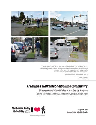
Shelbourne Valley Walkability Report May 2011
1. “No one can find what will work for our cities by looking at …
suburban garden cities, manipulating scale models, or inventing
dream cities. You’ve got to get out and walk.”
- ‘Downtown is for People’, 1957
Jane Jacobs
Creating a Walkable Shelbourne Community
Shelbourne Valley Walkability Group Report
for the District of Saanich, Shelbourne Corridor Action Plan
Shelbourne Valley May 12th, 2011
‘Sharing
Walkability Shelbourne’ Saanich, British Columbia, Canada
svwalkers@gmail.com
4. Acknowledgements
The Shelbourne Valley Walkability Group thanks the District of Saanich Area Planner, Harold Stanley, Saanich
Councilors and staff, and the Saanich Bicycle and Pedestrian Mobility Advisory Committee for their support
and encouragement. Thanks also to Jim Hemstock, Saanich Manager of Transportation, for addressing
immediate safety concerns identified during the walkability assessments.
The inspiration to gather the data and prepare this report came by the example shown by the Greater Victoria
Cycling Coalition Report to the Shelbourne Corridor Action Plan (SCAP) Stakeholders Committee in May
2010; mapping the existing cycling routes, the challenges to cycling and recommended solutions.
We thank the staff and residents of the seniors’ residences: Berwick House, Dawson Heights, Luther Court,
and Highgate Lodge, for their participation in the walkability presentation and consultations, and for their
valuable input and insights; the Doncaster Elementary School Parent Advisory Committee, and the students
of Dr. Lisa Kadonaga at University of Victoria and Camosun College who are applying their research skills to
walkability assessments.
The Shelbourne Valley Walkability Group Shelbourne Valley
‘Sharing
Ray Travers, a Gordon Head area walker, and private Walkability Shelbourne’
forestry consultant, started the Walkability initiative,
and provides the organization and coordination for the group. Ray drafted the initial outline and helped bring
together the content of the report.
Soren Henrich, a Bowker Creek Initiative Steering Committee member, and past director of the North Jubilee
Neighbourhood Association, brings his background in community engagement through environmental
education, art, and graphic design skills to the group. Soren played a key role in organizing and displaying the
report’s content.
Jean Newton, a Shelbourne Valley resident and daily walker, is a social worker with a background in mental
health, journalism and community activism. Tom Newton has a background in mental health services
including program development for the seriously mentally ill, development of supportive housing and
community activism. Jean and Tom have undertaken community consultations, completed walkability
assessments, and provided many of the photographs included in this report.
Mei Ang, a Cedar Hill area resident and an advocate for a more livable community in the Shelbourne Valley,
brings ecological research, organization, writing, and community engagement with seniors and students in
the Shelbourne Valley.
Andrea Gleichauf, a Bowker Creek Initiative Steering Committee member, and Camosun Community
Association Director-at-large, is an advocate for watershed restoration and Bowker Creek as a form-making
feature of the Shelbourne Valley brings community engagement through ecological education and arts events,
is organizing a Jane’s Walk in May.
Pamela Williams, a Mount Tolmie area resident, brings her research, organization, historical perspective, and
mapping skills to the group.
We all share a passion for walkability and its capacity to help make the Shelbourne Valley more livable.
iv Shelbourne Valley Walkability Report – May 2011
5. Introduction
The Shelbourne Valley Walkability Group
was formed in September 2010. We are
citizen volunteers associated with the SCAP
Stakeholders Committee of the District of
Saanich.
This report is the result of community
educational outreach, on-the-ground
research, and consultation over a period of six
months to community associations, schools, Tom Newton photographing the pedestrian entrance to Home Depot from
Cedar Hill Road on October 20th, 2010; ‘Gordon Head Jane’s Walk’ test.
University of Victoria, Camosun College,
seniors residences, at the January 27, 2011
SCAP Open House, and from eye-witness accounts and photos from walking assessments in the
Shelbourne Valley neighbourhoods.
The purpose of this report is to provide walkability input to the SCAP, so our observations (photos
and assessments) and recommendations are available to inform the consultants, District of Saanich
staff, and others who live in the Shelbourne Valley.
“Our vision is to be an advocate, through
education and community engagement,
for walkable streets and neighbourhoods
in the Shelbourne Valley.”
There is still much more good work to do
by dedicated volunteers in engaging the
community. This report covers only a portion
of the geographic area in the Shelbourne
Valley, and some of the qualities important
to a high standard of walkability. More Shelbourne Valley Walkability Group on the multi-use path at Lambrick
Park on October 20th, 2010; ‘Gordon Head Jane’s Walk’ test.
information can be gleaned from everyone
who lives, works and plays in the valley; from
seniors who remember prior conditions and histories; from children, teenagers, students, and
families; from those who walk and the small minority who don’t or can’t. We sense broad public
support for improved walkability.
Factors that affect the quality of the walking experience include time of day and season; daily traffic
flow patterns including peak hours; and the legacy of urban sprawl since the end of World War Two.
Shelbourne Valley Walkability Report – May 2011 1
6. We welcome ongoing walkability research, and the involvement of adjacent neighbourhoods,
municipalities and neighbourhoods. Our goal is to transform the Shelbourne Valley into a walkable
community in harmony with other modes of transportation with benefits for everyone.
Our mission is to transform the Shelbourne Valley into a walkable community in
harmony with other modes of transportation including bicycles, buses, rapid
transit, scooters, strollers and vehicles.
To accomplish our mission, we will:
• Conduct walkability assessments;
• Identify walkability issues, problems and
propose solutions;
• Support the development of walkability
assessment tools that include both
quantitative and qualitative criteria to
more effectively characterize the walking
experience;
• Build alliances with other community
organizations with a similar vision and
A wide boulevard and trees along Cedar Hill Road near Canadian Tire,
mission; provide a safe buffer between road traffic and the walkway. Pedestrians
feel safer. The walk is more pleasant.
• Conduct walkability consultations with
community groups seeking their input and
support on solving walkability problems and proposing solutions;
• Engage the community in dialogue on the qualities, values and benefits of walking in the Shelbourne
Valley;
• Fully recognize the contribution of walking as a significant part of our Saanich quality of life and
people of all ages. Everyone walks.
• Encourage transportation planners to elevate the importance of walkability so it has equal status
with other modes of transportation;
• Encourage policy makers to fully recognize the economic value of walking so its full economic
benefits are accurately recognized in transportation priorities, plans and budgets;
• Promote objective criteria in improve the allocation of funds for investments in walkability
infrastructure (e.g. sidewalks) to locations with the greatest need and incremental benefit.
• Promote traffic management concepts that improve walkability while reducing traffic speed and
keeping traffic moving, such as traffic circles, road diets, and complete streets;
• Favour urban renewal policies that support increased population density along major roads, mixed
land use, and increased connectivity of urban neighbourhoods;
• Favour land use and traffic management practices that reduce the carbon footprint;
• Favour technological innovations that encourage walking while reducing dependence on the
automobile, especially where goods and services are accessible and convenient;
• Integrate planning for improved walkability with restoration of natural habitats in the Shelbourne
Valley’s ecosystem.
2 Shelbourne Valley Walkability Report – May 2011
7. Context Feltham
The SCAP Stakeholders Committee recognizes the Shelbourne
Corridor (as it is known to traffic engineers) is part of a watershed
McKenzie
known as the Shelbourne Valley. Prior to European colonization, this
watershed was a local food source for First Peoples. Early settlers
farmed the land, drained wetlands, and accelerated the flow of water Ce
dar
Hil
lX
into Bowker Creek. After World Two, most farms became residential
subdivisions, shopping malls, parking lots, churches, schools, and
Hill
Rich
Shelbourne
parks. Roads were paved and most of the creek buried in underground
Cedar
mon
pipes. Sidewalks were often secondary to roads required by the
d
automobile that now dominated this pattern of urban development.
Much of this can change for the better, if we choose.
North Dairy
Definition City of
Victoria
Walkability is a “measure of how
The Shelbourne Corridor walkability
friendly an area is to walking.” study area is in the Shelbourne Valley
Walkability has many health, environmental, and economic benefits. Factors influencing walkability
include the presence or absence and quality of footpaths, sidewalks or other pedestrian right-of-
ways, traffic and road conditions, land use patterns, building accessibility, and safety, among others.
Walkability is an important concept in sustainable urban design.
See Appendix I, Walkability Checklist for Assessments
Walkability is: “The extent to which the built environment is friendly to the presence
of people living, shopping, visiting, enjoying or spending time in an area.”
Dan Burden (www.walkable.org) states:
A walkable community is designed for people, to human scale, emphasizing people over cars,
promoting safe, secure, balanced, mixed, vibrant, successful, healthful, enjoyable and comfortable
walking, bicycling and human association. It is a community that returns rights to people, looks
out especially for children, seniors and people with disabilities and takes aggressive action to
reduce the negative impacts of sixty-plus years of auto-centric design and uncivil driving practices.
It is also a community that emphasizes economic recovery of central neighborhoods, promotes the
concepts of recovering and transforming suburban sprawl into meaningful villages, and especially
takes ownership and action to protect and preserving open space.
A walkable community, like a livable community, smart growth community, or sustainable
community, makes a neighborhood, hamlet, village, town, city or metropolis into a place where
many people walk, ride bicycles and use transit, and where anyone who drives a car moderates
Shelbourne Valley Walkability Report – May 2011 3
8. their behavior in a way where they take nothing from the rights of those who wish to stay healthy
and active by taking part in activities outside the car.
A walkable community is one that is old, historic, well worn, restored sensibly and worthy of
protection. A walkable community is one that is compact, new, fresh, invigorating and teaming
with people enjoying their streets, parks, plazas, buildings and other physical space.
See the Appendix IV for Dan Burden’s Walkability Performance Indicators.
Walkability Group Community Engagement in the Shelbourne Valley
Community Consultations and Presentations:
• Two viewings of Dan Burden’s “Active in Action: New Principles for a Sustainable World”, that Dan
Burden initially presented at Simon Fraser University (April 21, 2010). The first showing of this video
was at Saanich Municipal Hall on August 11, 2010, and the second on November 18, 2010 at the
Gordon Head Recreation Centre.
• Community engagement at the SCAP Open
House at St. Aidan’s Church Hall; January 27,
2011
• Quadra Cedar Hill Community Association,
January 25, 2011
• Camosun Community Association Directors’
Meeting, March 10th, 2011
• District of Saanich Bicycle Pedestrian Safety
Advisory Committee Walkability Presentation,
February 17, 2011
Seniors’ residences: Absence of dedicated pedestrian walkways into shopping plazas, and
dangerous walking conditions in parking lots present safety concerns for
• Highgate Lodge pedestrians.
• Dawson Heights
• Luther Court
• Berwick House
Assessment Walks
• Cedar Hill X Road/Shelbourne/Cedar Hill
area with Saanich staff, members of the
Walkability Group, and 25 seniors from Luther
Court, Highgate Lodge, and Dawson Heights,
on April 14, and the Cedar Hill Road area with
Jim Hemstock, parents from Doncaster School
For pedestrian safety and convenience, crosswalks need to be located
and members of the Walkability Group, on where people want to cross the street.
April 18th, 2011.
4 Shelbourne Valley Walkability Report – May 2011
9. Jane’s Walks
The Shelbourne Valley Walkability Group
will host three Jane’s Walks on May 7, 2011,
(north to south) starting and ending at:
• Gordon Head Recreation Centre
• Cedar Hill Cross Road and Shelbourne
• McRae and Shelbourne
Consultations and Presentations to Educational
Institutions and Community Associations
• Doncaster Elementary, Doncaster School
Parent Advisory Committee (DPAC), March
3, 2011
• University of Victoria, Geography Class (SSM
A102), March 11, 2011
• Camosun College, Walkability Presentation,
March 16, 2011
• Cedar Hill Middle School Parent Advisory
Council (CHILLPAC) April 11th, 2011
• Camosun Community Association,
Walking conditions on sidewalks are hazardous when pavement is broken,
Walkability Presentation, March 10, 2011 littered and uneven, as is the case on most sidewalks in the Shelbourne
• Quadra/Cedar Hill Community Association, Corridor.
Walkability Presentation, January 28, 2011
Issues for Pedestrians in the Shelbourne Valley
• Most sidewalks in the Shelbourne Valley are too narrow for two people walking in opposite
directions to comfortably pass one another. This is especially a problem for those riding on
motorized scooters or pushing baby carriages. On Cedar Hill Road and Richmond Road, there are
long stretches where there are no sidewalks on either side of the street.
• Sidewalks immediately adjacent to the street offer pedestrians no separation from traffic.
• Walking conditions on sidewalks are hazardous when pavement is broken, littered and uneven, and
common on most sidewalks in the Shelbourne Valley.
• Sidewalks blocked by utility poles, trees, garbage receptacles and other obstructions impede walking.
• Pedestrian traffic is blocked when buses are loading, and when bus passengers are waiting on the
sidewalks. This occurs at most bus stops on Shelbourne Street.
Shelbourne Valley Walkability Report – May 2011 5
10. • Walking is less pleasant with few parks and public spaces where people can sit down, talk with
friends and enjoy nature.
• For pedestrian safety and convenience, more crosswalks are needed where people frequently cross
Shelbourne street. Jaywalking is common.
• At intersections, rounded corners on sidewalks and limited space force pedestrians to stand
dangerously close to traffic.
• Speed of traffic on major streets in the Shelbourne Valley is a major disincentive to walkability
because pedestrians feel unsafe and vulnerable to a motorist losing control of their vehicle.
Pedestrians also quote noise and traffic fumes as barriers to walking on busy streets
• Absence of dedicated pedestrian walkways into shopping plazas, and dangerous walking conditions
in parking lots present pedestrian safety concerns.
Walkability Assessments Definition of Terms and Methods
Pedestrians
Major references used in this section are “Designing Sidewalks and Trails For Access, Part 1 and
Part 2 ” by the U.S. Department of Transportation Federal Highway Administration (1999, 2001)
and “Sidewalk design, construction, and maintenance” by the Federation of Canadian Municipalities
and National Research Council (2004).
Pedestrians are defined here as people who travel on foot or who travel with the aid of mobility
devices such as wheelchairs, scooters and baby strollers. Rollerskaters and skateboarders are
considered by some to be pedestrians.
Pedestrians come in all sizes, shapes and ages. They have different walking characteristics and needs.
They can be broadly grouped as follows:
1. Seniors
Aging causes a general deterioration in our physical, sensory and mental abilities. These effects are
most pronounced in the later years of our life.
Seniors may have decreased physical endurance and ability to walk. As a result, they may walk more
slowly and may need to take more frequent breaks to rest. Negotiating poor quality pavements
and obstructions on sidewalks can be a problem for them because of decreased agility, balance and
stability. Many walk with the aid of mobility devices such as walkers and scooters. The joints of
seniors often have reduced strength and flexibility, especially from arthritis, resulting in reduced
skill in performing tasks such as manipulating objects like traffic light buttons. Common walking
concerns are insufficient time to cross intersections, poor sidewalk surfaces and insufficient number
of rest stops.
6 Shelbourne Valley Walkability Report – May 2011
11. Many seniors have vision and hearing problems which make reading signs and watching out for
traffic and sidewalk obstructions difficult. They may also be unable to react quickly to dangerous
situations due to slower reflexes. Reduced mental abilities may result in poor judgement and
decision-making skills.
The Shelbourne Valley has a high concentration of seniors. In 2006, there was a total of 11,014
people living in the Shelbourne Valley. Of this, 2,544 (23.1%) were over the age of 65 which is about
5% higher than for Saanich as a whole. The population of seniors in Saanich is expected to increase
over the coming years and we can expect to see more in the Shelbourne Valley.
2. Adults
Adults are the broad group of pedestrians found between the seniors and young adults. They have
generally unimpaired physical, sensory and mental abilities and can be considered as the group of
pedestrians without “age-specific special needs”. This group does not exhibit a standard pedestrian
walking profile but instead has a wide range of variability in walking characteristics.
3. Young Adults
Young adults are in their late teens and twenties. They are usually physically agile and have quick
reflexes. They can walk fast and sidewalk obstructions are usually not a problem. They may have a
tendency to take risks and make impulsive decisions such as dashing across the road in heavy traffic.
Many skateboarders and rollerskaters are young adults.
Many young adults live and study in the Shelbourne Valley. Victoria’s two largest institutions of
higher learning, University of Victoria and Camosun College, are located on the eastern edge. St.
Michaels University School, Lambrick Park Secondary and Mount Douglas Secondary School are
located in or near the Shelbourne Valley.
4. Children
Children are vulnerable pedestrians because of their developmental immaturity and lack of
experience. Their peripheral vision is not fully developed. They are less able to judge speed and
distance accurately and may not understand road signs, traffic signals and complex traffic situations.
Children are also prone to unpredictable and impulsive actions such as suddenly dashing across the
road.
Doncaster Elementary School, Campus View Elementary School, Cedar Hill Middle School, Gordon
Head Middle School and Lansdowne Middle School are located in or near the Shelbourne Valley.
Many children walk to and from school by themselves and road safety is a huge concern of their
parents.
Shelbourne Valley Walkability Report – May 2011 7
12. 5. People With Disabilities
This category encompasses all age groups. Disabilities can be divided into these three types: mobility,
sensory and mental.
People with mobility impairments often use wheelchairs, scooters, canes and walkers.
Wheelchairs and scooters require a wider path of travel than other pedestrians. Therefore, sufficient
passing space is required to allow these users to pass each other and to turn around on sidewalks.
Wheelchairs and scooters can travel much faster than other pedestrians and conflicts can sometimes
arise. The stability and control of these devices can be negatively affected by steep grades, poor
pavement conditions and sidewalk obstructions such as utility poles and trees. Since they are seated,
wheelchair and scooter users may have problems accessing the buttons of user-automated traffic
lights and out-of-reach amenities such as public mail boxes and water fountains. All these issues are
commonly encountered in the Shelbourne Valley.
People who use canes and walkers tend to move slowly, have reduced endurance, have difficulty
negotiating steep grades and react more slowly to dangerous situations. It is also more difficult
for them to bend down to pick up things from the floor. The quality of sidewalk surfaces can
significantly affect their ease and safety of travel . Cracks, uneven surfaces and steep cross grades on
sidewalks can cause tripping and serious injuries. It is difficult to push walkers over debris and grass
on the edges of sidewalks.
People with visual impairments usually use white canes, and sometimes guide dogs. They can be
assisted through the provision of wayfinding information such as audible traffic signals and tactile
sidewalk surfaces with grooves or raised structures which can be felt with a cane. Older pedestrians
sometimes have both visual and hearing impairments so audible traffic signals need to be loud
enough to be heard over traffic noise.
People with mental impairment may have problems understanding traffic signs and complex traffic
situations. Some find traffic signals at intersections confusing.
In the Shelbourne Valley, seniors are the largest group of pedestrians with walking disabilities.
Sidewalk Designs And Standards
Assessing the technical and engineering aspects of sidewalks is outside the scope of the Shelbourne
Valley Walkability Group’s work. Instead, the Group’s focus is on collecting general sidewalk
information such as width, surface conditions, obstructions and conditions of amenities.
With the enactment of the Americans with Disabilities Act (ADA) of 1990, the U.S. Department
of Transportation was required to develop and legislate national sidewalk design standards to
accommodate people with disabilities. Canada does not have a similar Canadian with Disabilities
Act. However, the Federation of Canadian Municipalities and the National Research Council
8 Shelbourne Valley Walkability Report – May 2011
13. (2004) have jointly issued a manual on sidewalk design and construction guidelines. Based on
recommendations from these two bodies, the Group is adopting the following sidewalk width
standards:
1. The recommended minimum width for buffered sidewalks is 1.5m (almost 5 feet). This width
provides just enough space for wheelchair and scooter users to pass each other and to turn around.
A buffer is the strip of land separating the sidewalk from road traffic. It is often planted with shrubs
and trees. The buffer is often referred to as a boulevard in Saanich. Utility poles, newspaper boxes,
bus-stop signs, street signs and benches are some of the items which are often located in the buffer
zone.
2. The recommended minimum width for unbuffered sidewalks is 1.8m (almost 6 feet). The extra
width is needed to provide pedestrians with some separation from the traffic and to ensure that
wheelchairs and scooters can safely pass each other without tripping over the edge of the curb..
3. The minimum clear width is 0.915m (36 inches). This is the minimum width that is required to
provide enough space for people who use mobility devices such as wheelchairs, walkers and
crutches to safely manoeuver along the sidewalk. Widened sidewalk space (this can include
driveways) of at least 1.5 m wide should be provided at regular intervals in order to allow
wheelchairs and scooters to pass each other.
On busy roads with high numbers of pedestrian, sidewalks should be wider than the recommended
minimum widths in order to accommodate pedestrians walking more than two abreast. Wider
sidewalks are also needed in busy shopping areas to accommodate street furniture.
In Saanich, the Pedestrian Priorities Implementation Plan (2006) specifies that, in the urban area,
major roads are required to have two sidewalks, collector roads to have at least a sidewalk on one
side and local roads to have none. Sidewalks are to have a width of 1.5m.
Pedestrian Level Of Service
Saanich’s existing method for evaluating the Pedestrian Level of Service (PLOS) is defined in its
2006 Pedestrian Priorities Implementation Plan as:
“The pedestrian level of service model – or pedestrian safety index (PSI) – is a quantitative measure
of the perceived comfort and safety of current conditions on all major and collector roadways in
Saanich. It compares (using a mathematical formula) the pedestrian comfort and safety of roadways
with a numerical rating. The factors include lane width, facility width, vehicle speed and vehicle
volume. The posted speed, width of sidewalk and a buffer area between the sidewalk and roadway
are the primary factors that influence the PSI for a particular segment of road”
In the April 2011 Status Report for the Shelbourne Corridor Action Plan, traffic consultant Urban
Systems, rated the Shelbourne Pedestrian Level of Service (PLOS) as “C” on the basis of this model.
Shelbourne Valley Walkability Report – May 2011 9
14. In the 2006 Pedestrian Priorities Implementation Plan, PSI is calculated using a mathematical
formula that considers only the physical factors of sidewalks, roads and traffic. Although measuring
“perceived comfort and safety” is the objective, this model is deficient since it does not include
measures of the quality of the pedestrian experience (human perceptions) or sidewalk conditions
(sidewalks may exist but be in poor, unsafe conditions).
One of the Shelbourne Valley Walkability Group’s main objectives is to obtain feedback from
Shelbourne Valley residents about their walking experiences. In this way, we hope to provide a
human perspective on “pedestrian level of service”. Walkable communities can only be created if
pedestrians feel safe and comfortable about walking in the Shelbourne Valley.
Walkability Assessments - Methods
Saanich’s urban roads are classified under three categories : major roads, collector roads and local roads.
The roads of the Shelbourne Valley are systematically assessed starting with the major and
collector roads: the North-South roads (Shelbourne Street, Cedar Hill Rd, Richmond Road) and
the East-West roads (Feltham, McKenzie, Cedar Hill X Rd, north side of North Dairy Rd). For ease
of assessment, these roads are divided into segments with the boundaries determined by their
intersections with other major or collector roads. The local roads are assessed with priority being
placed on connector roads which carry more pedestrians.
Walkability information is obtained in these ways:
1. Assessments by Walkability Group members with the aid of a Walkability Checklist (Appendix I).
2. Consultations with schools and senior residences.
3. Conversations with pedestrians on the road, and with neighbours and friends.
4. Student assignments and assessments by volunteers.
10 Shelbourne Valley Walkability Report – May 2011
15. Photographic Assessments of Walkability by Area
Shelbourne from Feltham to McKenzie
Feltham
Shelbourne
McKenzie
Pedestrians walk along the inside edge of sidewalk because there is no
buffer from traffic. Note the path in the grass worn by walkers seeking
greater distance from the street.
Ce
dar
Hil
lX
Hill
Rich
Shelbourne
Cedar
mon
The walkway to medical offices near Feltham and Shelbourne offers safe Sidewalks on Shelbourne near Feltham are obstructed by utility poles that
d
access for pedestrians. create barriers for pedestrians, especially those using walkers and scooters.
North Dairy
City of
Victoria
The rounded corner at Feltham and Shelbourne encourages traffic to turn Benches in the area of Home Depot are placed directly facing Shelbourne
without stopping and is dangerous for pedestrians, who have little space Street and are seldom used because of the proximity of traffic.
on the sidewalk to stand back from traffic.
Shelbourne Valley Walkability Report – May 2011 11
16. Sidewalk on Shelbourne in front of Home Depot meets criteria of 1.5m The multi-lane entrance/exit to the Esso car wash at Shelbourne near
width with a narrow barrier from street traffic. McKenzie poses a risk to pedestrians because motorists pulling out of the
car wash are paying attention to traffic, not walkers.
Proposed Improvements
• All sidewalks on both sides of the street in this segment of Shelbourne need to be reconstructed with
buffers to traffic.
Feltham
• Benches need to be placed away from the street in a setting that offers comfort and facilitates the
opportunity for people to sit and talk.
• Rounded corners at intersections need to be re-evaluated and options considered that will meet the
requirements of safety vehicles (such as fire engines) and the safety needs of pedestrians waiting to
cross the street.
Shelbourne from McKenzie to Cedar Hill X Road McKenzie
Ce
dar
Hil
lX
Hill
Rich
Shelbourne
Cedar
mon
Intersections at Shelbourne and Cedar Hill X Road are dangerous
d
for pedestrians because of heavy traffic and rounded corners, which
encourage motorists to turn without stopping.
12 Shelbourne Valley Walkability Report – May 2011
17. Pedestrians enter Shelbourne Village through the Petro-Can gas bays. The bus stop at Shelbourne near Cedar Hill X Road has extremely limited
space for people to wait for the bus/exit the bus. There is no shelter and
only one small bench. Frequently this bus stop is crowded with students.
Sidewalks are directly next to the street with no boulevards, bike lanes or parking to provide separation from traffic.
There are four vehicle entrances to the parking lot at Coast Capital on Shelbourne and Cedar Hill X Road and no pedestrian dedicated entrances.
Pedestrians have created mud paths into the parking lot, which is usually blocked by a parked vehicle and occasionally by snow.
Shelbourne Valley Walkability Report – May 2011 13
18. Feltham
Proposed Improvements
• The municipality should require developers to provide dedicated pedestrian access to shopping
centres in new development and encourage such access in existing plazas.
• Green spaces with benches need to be added to this segment of the street. McKenzie
• The bus stops need to be set back to prevent congestion that blocks pedestrian traffic on the
sidewalk.
Ce
Shelbourne from Cedar Hill X Road to North Dairy da
rH
ill X
Hill
Rich
Shelbourne
Cedar
mon
d
There is no crosswalk at Shelbourne and Church Street, where pedestrians
frequently cross at their own peril!
North Dairy
City of
Victoria
“Sidewalk” on Shelbourne near North Dairy measures less than one metre Utility poles obstruct sidewalk.
in width.
14 Shelbourne Valley Walkability Report – May 2011
19. Sidewalk is too narrow for people walking in opposite directions to pass A broken asphalt path serves as sidewalk on the west side of Shelbourne
one another. from Rowan Street to North Dairy. Pavement is barely wide enough for a
baby stroller.
Gore Park and the sidewalk in front of McDonalds is ideal with wide A pedestrian is forced to walk into Shelbourne Street to get around a deep
sidewalks, clean, unbroken pavement and a grass boulevard that pool of water that stands on the sidewalk whenever it rains.
provides pedestrians with safe space from traffic.
West side of Shelbourne near McRae facing south East side of Shelbourne near McRae facing north. The
with a narrow asphalt path around utility pole. The bus shelter provides a protected refuge for commuters.
proximity to fast-moving vehicle traffic is a hazard. The starkly unused sidewalk is typical. Loud traffic
noise makes it unpleasant to walk.
Shelbourne Valley Walkability Report – May 2011 15
20. Proposed Improvements
• The sidewalk by Gore Park and McDonald’s
serves as a model for sidewalk on this segment
of Shelbourne.
• There needs to be a crosswalk at Shelbourne
and Church Street and also at Knight Street
and Shelbourne. Presently there are too few
crosswalks along this stretch of the street.
• On the west side of this segment of
Shelbourne, there are several undeveloped Browning Park offers an oasis on this otherwise inhospitable stretch of
sidewalk. This is the only playground for children (other than McDonald’s
lots which, if purchased by Saanich, could be Play Land) in the area. Feltham
developed as pocket parks with benches, trees
and greenery.
• This segment of Shelbourne Street would be a good place to build a seniors’ centre.
• Walkability all along Shelbourne would be improved if utility poles were placed underground.
• Residents in the Shelbourne Valley have indicated they would like a community feeling in the
shopping/service areas. Better sidewalks, more greenery and the creation of public meeting spaces
would help build community. McKenzie
Cedar Hill X Road from Cedar Hill Road to Shelbourne Ce
dar
Hil
lX
ill
Rich
H
Shelbourne
Cedar
mon
d
Good sidewalks in front of Highgate Lodge are smooth with unbroken
pavement and a boulevard providing separation from traffic.
North Dairy
16 Shelbourne Valley Walkability Report – May 2011
City of
Victoria
21. Crowded, narrow sidewalk forces a pedestrian walking in the opposite Crossing buttons on utility poles at crosswalks are not positioned where
direction to step into the street. seniors on scooters or in wheelchairs can access them without difficulty.
This narrow, mud path is the only pedestrian entrance on Cedar Hill X Seniors living at Luther Court and at Highgate Lodge presently have
Road into the Coast Capital plaza. Many seniors, including those who use no safe way to cross Cedar Hill X Road between Cedar Hill Road and
scooters and walkers, and those with impaired vision go to the optometrist Shelbourne. Many dangerously jaywalk across Cedar Hill X Road at Ophir.
whose office is located at this centre.
Sidewalk on Cedar Hill X Road near Luther Court is uneven and broken by tree roots. This is especially hazardous for the many seniors who walk in this area.
Shelbourne Valley Walkability Report – May 2011 17
22. Proposed Improvements
Feltham
• Sidewalks on both sides of this segment of Cedar Hill X Road need to be constructed like those in
front of Highgate Lodge. Wide, smooth sidewalks are especially important in this neighbourhood
where more than 400 seniors reside in the Highgate, Luther Court and Dawson Heights residences.
• There needs to be a lighted crosswalk at Cedar Hill X Road and Ophir. The distance between existing
crosswalks is too great for seniors with limited mobility and limited energy.
• Several benches, on paved pads and set back from traffic, need to be installed on both sides of the
street. Benches need to be well maintained.
McKenzie
• Crossing buttons need to be repositioned so they can be easily reached by those using wheelchairs
and scooters. Traffic lights need to be set to allow sufficient time for seniors to cross the road safely.
Cedar Hill X Road from Shelbourne to Iona Ce
dar
Hil
lX
Iona
Hill
Rich
Shelbourne
Cedar
mon
d
Pedestrians walking on the south side of Cedar Hill X Road must cross two
expansive, multi-lane driveways where motorists enter Shelbourne Plaza.
Motorists frequently block the sidewalk and pay more attention to traffic
than to pedestrians.
North Dairy
City of
Victoria
Sidewalk is obstructed by utility poles. There is no buffer to street traffic. Horner Park, located just off Cedar Hill X Road at Iona, is a pretty, multi-use
park that provides green space for this area.
18 Shelbourne Valley Walkability Report – May 2011
23. The sidewalk on Cedar Hill X Road by Mt. Tolmie Care Facility is less than There is no crosswalk on the south side of Cedar Hill X Road at Richmond.
one metre wide at a point where the street curves, creating a risk for For pedestrians to cross in dedicated crosswalks, they must cross four
pedestrians. segments of road to get from the south to the north side of Cedar Hill X
Road. Almost everyone jaywalks.
Proposed Improvements
• Traffic engineers need to reconstruct the chaotic Richmond/Cedar Hill X Road/Poplar Street
intersection to create safety for cyclists and pedestrians.
• Sidewalks in this segment of road need to be widened to meet minimum criteria of 1.8 metres for
unbuffered sidewalk or 1.5 metres for buffered sidewalk.
• Utility poles need to be placed underground.
Cedar Hill Road from Feltham to McKenzie
Feltham
ill
Cedar H
McKenzie
From Feltham to Arrow, there is no sidewalk at all on the west side of the
street. A care aid pushes a man in a wheelchair up Cedar Hill Road in the
bike lane because sidewalk on the east side of the street is too slanted to
navigate due to broken, uneven pavement.
Ce
dar
Hil
Shelbourne Valley Walkability Report – May 2011 lX 19
na
24. Slanted sidewalk on the east side of Cedar Hill Road near Feltham. There is no crosswalk at Feltham and Cedar Hill Road, though there is a sign for
pedestrian crossing.
There is no pedestrian access to the Canadian Tire Mall off Cedar Hill Road A short stretch of smooth sidewalk with grass buffer on the east side of
other than a driveway for autos. Cedar Hill Road near McKenzie.
Proposed Improvements
• There needs to be a traffic light and crosswalks installed at Cedar Hill Road and Feltham.
• New sidewalk with buffers needs to be constructed on both sides of the street.
• There needs to be a dedicated pedestrian entrance to the Canadian Tire shopping centre.
20 Shelbourne Valley Walkability Report – May 2011
25. Feltham
ill
Cedar H
Cedar Hill Road from McKenzie to Cedar Hill X Road
McKenzie
Ce
dar
Hil
lX
There is a good pedestrian pathway into the Fairway store at the corner of
McKenzie and Cedar Hill Road. This is one of the few dedicated pedestrian
entrances to any shopping plaza in the Shelbourne Valley.
Iona
Hill
Rich
Shelbourne
Cedar
mon
d
The pedestrian crosswalk across Cedar Hill Road at Gregory ends on the The sidewalk at the intersection on Gregory Street is a broken, muddy mess
east side in a concrete hole and muddy lawn. North Dairy
during even mildly wet weather. Parents and teachers at Cedar Hill Middle
School are concerned about safety of children because of high traffic
volume in this drop off area.
City of
Victoria
Pedestrians frequently jaywalk across Cedar Hill Road at Garnet. Sidewalk by Cedar Hill Middle School is often muddy and sometimes
blocked by vehicles that park along this side of the street.
Shelbourne Valley Walkability Report – May 2011 21
26. Proposed Improvements Feltham
• A pedestrian crosswalk at Cedar Hill Road and Garnet would provide safety for walkers who cross
ill
there to go to the library, catch the bus and walk to their homes in this fairly densely populated area.
Ce d ar H
• The sidewalk by Cedar Hill Middle School needs a barrier to separate pedestrians from the cars that
park along the street.
• Consultation by Saanich traffic engineers with parents and teachers at Cedar Hill Middle School is
necessary to address the safety concerns for school children on Gregory Street. McKenzie
• The muddy areas and the hole in the lawn at the crosswalk at Cedar Hill Road and Gregory needs to
be repaired and paved.
Ce
Cedar Hill Road from Cedar Hill X Road to North Dairy dar
Hil
lX
Iona
Hill
Rich
Shelbourne
Cedar
mon
d
There is no crosswalk at Cedar Hill Road and Church Street. The traffic
island is not helpful to those using a walker, scooter, cane or who have
unsteady footing. North Dairy
City of
Victoria
Sidewalk on the east side of the street by the condo development at 3633 Deteriorated, broken asphalt sidewalk is typical of that on most of the east
Cedar Hill Road is in good condition with a buffer providing separation side of Cedar Hill Road.
from traffic.
22 Shelbourne Valley Walkability Report – May 2011
27. Busy intersection at the corner of McRae/Doncaster and Cedar Hill Road has no crosswalk. This is a major pedestrian thoroughfare.
There is no sidewalk from Church Street to Doncaster Street on the west Rowan Street by Doncaster School is the area where parents drop off/pick
side of Cedar Hill Road. Pedestrians have created pathways on lawns. up school children. It is dangerous because there are no sidewalks and
children dart in and out between cars during heavy traffic before and after
school.
Doncaster parents are concerned that the bus stop by the store across Bus stop on the west side of Cedar Hill Road at Doncaster where there is no
from the school is a dangerous place for children due to the speed at which sidewalk and those waiting for the bus stand in the street.
some motorists pull up in front of the store.
Shelbourne Valley Walkability Report – May 2011 23
28. Proposed Improvements
• A lighted crosswalk needs to be constructed at
Church and Cedar Hill Road to assist seniors
in crossing there.
• Sidewalks and bike lanes should be
constructed on both sides of Cedar Hill
Road from Feltham to North Dairy. At a
consultation with parents at Doncaster School,
a proposal was made to use Henderson Street
as a model for building sidewalks and bike There is no pedestrian walkway into Cedar Hill Rec Centre from
lanes on Cedar Hill Road. Cedar Hill Road. Pedestrians enter via a busy driveway.
Feltham
• Parents and seniors would like the speed limit
on Cedar Hill Road to be decreased to 40 kmh with a speed limit of 30 kmh in the section between
ill
Cedar H
Doncaster School and Cedar Hill Middle School.
• There needs to be a traffic light and crosswalk at McRae/Doncaster and Cedar Hill Road.
• Sidewalk needs to be constructed on Rowan Street by Doncaster School.
McKenzie
• There needs to be a dedicated pedestrian entrance on Cedar Hill Road into the Cedar Hill Rec
Centre.
Ce
Richmond Road from Cedar Hill X Road to North Dairy dar
Hil
lX
Richmond Road is about 1.6 km long and is a two-lane road. It starts in
the North at the intersection with Cedar Hill X Road and traverses the
Iona
Shelbourne Valley in a south-easterly direction. Its Shelbourne Valley
Hill
Rich
boundary is at Lansdowne Road. High density housing (apartments
Shelbourne
Cedar
and townhouses) is found around the intersection with Cedar Hill X
mon
Road together with the Mt Tolmie Extended Care Hospital. St Michaels
University School is located on the west side between Knight Ave and
d
McRae Avenue. It has 778 students from Grade 6-12 of which 250 live
on campus as boarders. Camosun College is located on the east side
near the Lansdowne intersection. Student enrolment for the Winter
2011 session is 9381. Single family houses are found along the rest of
the road.
This assessment incorporates feedback from 11 Camosun College North Dairy
students who did walkability assessments for their Geography 100
City of
project.
Victoria
24 Shelbourne Valley Walkability Report – May 2011
29. East Side Of Richmond Road
Number Section Length Width Buffer Condition
1 Cedar Hill X to Kingsberry 140m 1.6m No Good condition
2 Kingsberry to Mayfair 560m na na No sidewalk, just dirt paths
3 Mayfair to Waterloo 265m 1.2m No Old, except for new stretch at Barefoot
yoga place; serviceable
4 Waterloo to Argyle 215m na na No sidewalk, just dirt paths
5 Argyle to Lansdowne 260m 2.0m Yes Good condition
Total sidewalk length 1440m
• The sidewalk from Cedar Hill X Road to Kingsberry Crescent is in good condition. At 1.6m wide, it
does not meet the recommended 1.8m minimum standard for unbuffered sidewalks. It has a
sheltered bus stop but space on the sidewalk is tight. A short distance from the Kingsberry Crescent
intersection, the sidewalk ends abruptly with a tree in the way. A short dirt track connects it to
Kingsberry Crescent.
• The long stretch from Kingsberry Crescent to
Mayfair Drive does not have a sidewalk. Dirt
tracks form messy pedestrian walkways which
are sometimes located right next to the road.
Passage is blocked by parked cars in many
places forcing pedestrians to wait for a break
in traffic in order to go around the cars. An
odd island at the Mayfair Drive intersection
separates the two out-bound lanes. The north
lane is a hazard to pedestrians because of the
blind corner. Mayfair Drive provides access to Dirt track on east side of the road blocked by a car.
Mt Tolmie Park.
• The sidewalk from Mayfair Dr to Waterloo Road does not meet the recommended minimum
unbuffered standard. It is old but in serviceable condition. The stretch at 3517A Richmond Road
(Barefoot at Heart yoga place) is new but unbuffered. At 1.7m, it almost meets the minimum width
standard. A nice, dedicated pedestrian path connects the sidewalk to the shop.
• The stretch between Waterloo Road and Argyle Avenue does not have sidewalks. An odd pedestrian
crossing sign is located among overgrown vegetation north of Ernest Avenue. There are no markings
on the road to indicate the presence of a pedestrian crossing.
• The sidewalk from Argyle Avenue to Lansdowne Road is mostly buffered and runs adjacent to
Camosun College. At 2m, it exceeds minimum width standards. A new bus shelter is found on this
stretch. People were observed jaywalking across the road to get to the bus stop on the west side.
In total, about half of the east side has no sidewalks.
Shelbourne Valley Walkability Report – May 2011 25
30. West Side of Richmond Road
Number Section Length Width Buffer Condition
1 Cedar Hill X to Poplar 40m 1.3m No Old but serviceable
2 Poplar to Pear 110m 2.0m Yes New, landscaped
3 Pear to Knight 590m 1.3m No Old, poor condition, cracked, patched,
steep cross grades across driveways
4 Knight to McRae 230m 1.3m Yes Old, cracked
5 McRae to Argyle 205m 1.3m Yes Old but serviceable
6 Argyle to Lansdowne 280m 2.0m Some Good condition
Total sidewalk length 1455m
• The short stretch of old sidewalk from Cedar Hill X Road to Poplar Avenue does not meet the
recommended minimum unbuffered standard of 1.8m. It is a very unpleasant place to walk being
located at the intersection of five roads with pedestrian-hostile crossings.
• The sidewalk adjacent to Richmond Gate
between Poplar Avenue and Pear St is the
best stretch on Richmond Road. It is wide and
exceeds recommended minimum standard, has
a pleasant, meandering passageway and the
buffer zone is spacious and nicely landscaped. A
bench is provided in a spacious, paved corner
at the intersection with Pear St. A good bus
shelter is located on this stretch.
• The sidewalk between Pear St and Knight New sidewalk at Richmond Gate.
Avenue is very old, haphazardly patched and
repaired, cracked and uneven. The cross grade
is so steep across some driveways that it is a
hazard for pedestrians with mobility aids and
strollers to use. A detailed listing of the many
problems along this stretch (and other
stretches) can be found in the student report
(Appendix VII). This sidewalk is beyond fixing
and repair; it needs to be replaced. This
sidewalk is often obstructed by parked cars.
Cedar Avenue is very steep and drivers
Pedestrian crossing sign with no road markings.
entering Richmond Road have poor sightlines.
• There is a narrow buffer of grass beside the sidewalk from Knight Avenue to McRae Avenue. A large
section of the sidewalk has long cracks running along its length. The location of the pedestrian
crossing just to the south of the Knight Avenue is not safe. Knight Avenue is very steep and visibility
26 Shelbourne Valley Walkability Report – May 2011
31. is poor for drivers entering Richmond Road.
There are no street lighting and pedestrian
crossing lights; and the pedestrian markings
on the road are faded.
• The McRae Avenue to Argyle Avenue sidewalk
is old and buffered. It is narrow and does not
meet the 1.5 m recommended standard.
However, compared to the previous stretch, it
is a huge relief to walk on this serviceable
sidewalk! McRae Avenue is very steep and Sidewalk on west side of the road completely blocked by a big truck and van.
drivers coming up the slope towards
Richmond Road have poor visibility of pedestrians.
• The north portion of the Argyle Avenue to
Lansdowne Road is buffered. It is in good
condition and meets the minimum width
standards. A new bus shelter is located here.
The absence of a pedestrian crossing for
students to use to get to and from Camosun
College is a big safety issue, especially during
rush hours. Jaywalking is the preferred way of
crossing the road since a person walking south
to the Lansdowne Road intersection has to
wait for the traffic lights to change and then Pedestrian crossing near the Knight Ave intersection.
has to walk back up north again to reach the
classrooms. This takes several more minutes and time is important when students are late for class.
Sidewalk space is very tight at the corner of the Richmond Road/Lansdowne Road intersection as
the fence of the corner property is almost next to the sidewalk.
General Issues
• Richmond Road is a very unpleasant and unsafe road for pedestrians. It is a road that is designed to
ensure unimpeded traffic flow for cars. There are no bike lanes except for a short stretch from Argyle
Avenue to Lansdowne Road and the pedestrian environment can generally be described as hostile.
• There is no safe and comfortable place to walk between Kingsberry Crescent and Mayfair Dr because
of dirt tracks on the east side of the road and a dilapidated sidewalk on the west side. It is impossible for
pedestrians with mobility issues to walk the length of the road and pushing baby strollers is a struggle .
• Heavy rush hour traffic and speeding cars create safety issues. Cars get backed up when the buses stop
to pick up passengers and impatient drivers by-pass the buses by crossing over to the opposite lane.
Shelbourne Valley Walkability Report – May 2011 27
32. • There is only one pedestrian crossing (south of Knight Avenue) in the whole 1.6 km stretch between
Cedar Hill X Road and Lansdowne Road . Pedestrians are forced to jaywalk across the road. There
is no crosswalk near the two heavily used Camosun College bus stops. Students from Doncaster
Elementary School have no place to cross safely to and from school.
• There are a total of 14 bus stops. Five have shelters (two near Cedar Hill X Road, two near
Lansdowne Road and one outside 3500 Richmond Road). All the others have a sign post standing in
either a small patch of dirt or crude concrete pad. Bus stops along the road are well-used as many
students from University of Victoria and Camosun College live in the surrounding area. The absence
of pull-in areas for buses create unsafe driving and walking conditions.
• There is no public space along the road for people to meet and play. Mt Tolmie requires a hike up
Mayfair Dr to access and the green space at St Michaels School is off-limits.
• A short stretch of dedicated bike lane next to Camosun College ends abruptly.
• Street lights are too far apart in places resulting in long stretches that are very dark and unsafe for
walking.
• Trees, utility poles and overgrown shrubbery block sidewalks in many places.
• Many houses are located down very steep driveways resulting in poor visibility when cars pull out
into Richmond Road. Thick vegetation around the driveways add to the danger.
• Students compare Richmond Road unfavourably with other places such as Cook St and Oak Bay
villages, Langford and Colwood. Along Dunsmuir St in Esquimalt, the buffer zone is used by
residents to create gardens.
Proposed Solutions
• At a minimum, the old sidewalk on the west side of Richmond Road needs to be replaced as it is
beyond repair. This will provide pedestrians with one continuous sidewalk for walking. Because
many houses are located on steep slopes below road level, attention needs to be paid to the design
of the cross grades across driveways in order to ensure a level surface that is safe for people with
mobility devices and strollers to use.
• Some re-thinking needs to be done regarding on-street parking policy. Is on-street parking a good
policy in making the best use of limited road space? It is catering to the needs of a few car owners at
the expense of pedestrians and cyclists. Cars obstructing pedestrian routes should be banned as it is
unsafe for pedestrians to have to walk around them.
• Many bus stops along the road need to be improved to provide adequate waiting space and shelter
from the rain. In addition, pull-off areas should be provided so that stopping buses do not impede
the flow of traffic.
28 Shelbourne Valley Walkability Report – May 2011
33. • Street lighting should be improved as many students live in the area and they are a group most likely
to go out and about at night.
• It is essential to provide a crosswalk at the bus stop area near Camosun College. Since the bus stops
are so close to the Lansdowne intersection, it may be necessary to locate the crosswalk a bit farther
north to align with the bigger college entrance way .
• Another crosswalk is needed in the Cedar Avenue area to enable students from Doncaster School to
cross the road safely.
• The Barefoot at Heart yoga place adds some street interest to Richmond Road; there are suggestions
that perhaps more small home businesses should be encouraged.
• One or two small neighbourhood parks will help to foster a sense of community.
Shelbourne Valley Walkability Report – May 2011 29
34. Summary and Recommendations
Walkability Group Report: “Creating a Walkable Community”
This report provides compelling evidence, (maps, photos and written assessments) that the conditions
for walking (including safety, comfort and convenience) immediately adjacent to Shelbourne Street
and other major Roads such as Richmond and Cedar Hill Road require significant improvements
before the whole Shelbourne Valley can become an attractive walkable community. Realization of this
vision will require significant policy and financial commitment by Saanich to improving basic mobility,
community livability, more efficient land use, reduced carbon footprint, improved fitness and public
health, economic development, and more equitable access to goods and services.
The current trend in traffic volumes on Shelbourne have been minimal or flat (April 2011 Interim
Report, Shelbourne Corridor Action Plan, Urban Systems Traffic Consultant)
In contrast to walking conditions along the Valley’s major roads and many connector streets,
conditions through the Valley’s parks and natural areas, such as Lambrick Park, Mt. Tolmie,
Cedar Hill Golf Course and Browning Park, are good. Walkability is also good on trails (such as
the Galloping Goose) and sidewalks beyond the Valley, but the incomplete network of trails and
sidewalks in Saanich are in need of overall rationalization and connectivity with the Valley.
Saanich residents are active walkers. Walking is a frequent recreational mode of travel reported
on a 2011 citizen survey and reported in the “Working Paper of the Saanich Parks and Recreation
Plan.” Of all respondents, 91 percent of Saanich residents reported they frequently walked. The
next highest mode of recreational travel was cycling at 33.8 percent. This mail in survey Saanich
Parks and Recreation obtained information about the use of amenities by residents, especially for
neighbourhood parks, trails, playgrounds and other recreation facilities.
http://www.saanich.ca/parkrec/pdf/UpdatedWP8HouseholdMailinsurveyresults.pdf
Source: Mail-in Survey Results in A Working Paper of the Saanich Parks and Recreation Master Plan
2011 Yates, Thorn & Associates Inc.
30 Shelbourne Valley Walkability Report – May 2011
35. Saanich Pedestrian Priorities Implementation Plan
In 2006, Saanich initiated the Saanich Pedestrian Priorities Implementation Plan (PPIP) as part of
the Safer City Program. This Plan guides Saanich policy and practices on addressing pedestrian
needs. The PPIP recognizes safety not only as important for walking but also for identifying
priorities for investments in the District’s sidewalk system. In the PPIP Saanich Road Standards are
defined for:
• Major Roads within urban areas have significant traffic volumes for longer distances and generally
support bus services and medium density development. Major roadways accommodate pedestrians
on both sides of the road with 1.5-meter concrete sidewalks, separated from the road where possible.
Some major roads have asphalt sidewalks.
• Collector Roads generally support travel between neighbourhood streets and major roads. They also
provide direct access to residential and/or commercial properties. Sidewalks are provided along at
least one side of collector roads, with a 1.5-meter asphalt or concrete sidewalk, separated from the
road where possible.
• Local roads typically carry lower traffic volumes and provide access to individual residential
properties - in contrast to collector and major roads. Through traffic on local roads is relatively
minimal typically resulting in lower speeds and lower volumes of traffic. In the District of Saanich,
sidewalks are not required on local roads unless designated as a Safe Route to School, are located in
a primary commercial area or adjacent to a significant multi-family housing development. In these
cases, 1.5-meter wide asphalt or concrete sidewalks are required.
PPIP Objectives
The objectives were of the PPIP to:
• “Identify sidewalk needs within the District to achieve current standards along various classes of
roadways and in key pedestrian areas.
• Establish priorities for the implementation of sidewalks based on locally defined criteria such as
safety, demand and overall contribution to the existing network of sidewalks.
• Identify improvement options and associated costs for alternative treatments, and
• Prepare an implementation strategy which identifies short-term, medium-term and long-term
priorities.”
Shelbourne’s Rank in the PPIP
The PPIP report ranks the pedestrian attributes of Saanich roads using six pedestrian criteria. These
criteria are summed into an overall aggregate rating of needs weighted to emphasize the District’s
objectives for a safe, comfortable and efficient pedestrian network. Six maps in the PPIP report illustrate
the rating designated for all major roads (including Shelbourne) in Saanich and many collector roads.
Shelbourne Valley Walkability Report – May 2011 31
36. The pedestrian level of service (PLOS) model– or pedestrian safety index (PSI) - is one of the
pedestrian attributes used, without modification, to measure the perceived comfort and safety of
current conditions on all major and collector roads in Saanich.
The PPIP report ranked Shelbourne as “4”, with a moderate to high degree of need for a safe,
comfortable and efficient pedestrian network.
PPIP Rating Shelbourne Rank (1 (low) to 5 (high)
Safety issues 10% Rank 1 Sidewalks 2 sides, collector 1 side (Fig 3.1)
Pedestrian safety index 10% Rank 3 Moderate comfort and safety (Fig 3.2)
Network contribution 25% Rank 1 Sidewalk 2 sides, with collectors (Fig 3.3)
Pedestrian demand 35 % Rank 5 High Pedestrian Demand (Fig. 3.4)
Transit proximity 10% Rank 5 High, < 250 km bus stop (Fig 3.5)
Urban priority: 10% Rank 5 High ( Fig. 3.6)
Aggregate Rating: 100% Rank 4 Moderate to High Degree of Need (Fig 3.7)
Source: Urban Systems. 2006. The Corporation of the District of Saanich. Pedestrian Priorities
Implementation Plan
Planning to Improve Walkability
Environments favorable for walking are favorable for people. Walking is a critical part of the
overall transportation system, connecting homes and bus transit, shopping to accessing goods and
services, and travelling to other community destinations. Walking is often chosen because it is more
convenient, comfortable and affordable than other modes of transportation.
Greater appreciation of the full benefits of walking is needed to accurately identify transportation
priorities. Realizing these benefits of walking will require more investment in infrastructure and
programs, shifting road space from traffic and parking lanes to sidewalks and paths, creating more
walkable land use patterns, and redesigning and better managing motor vehicle traffic to improve
walking safety, improving walking convenience and comfort to reduce automobile dependency, and
creating more accessible land use.
Walking is an essential part of the Shelbourne transportation system, which include increased
accessibility, increased community livability, improved public health, more effective land use and
more equitable policies and practices.
Conclusions
Walkability merits increased consideration in the Shelbourne Corridor Action Plan because:
• Shelbourne is ranked as moderate to high need for improvement in the PPIP;
32 Shelbourne Valley Walkability Report – May 2011
37. • Walking is an important recreational activity of Saanich residents;
• Mobility and accessibility to goods and services in short and long journeys has high social and
economic value to residents;
• Walking with access to services is important to people with disabilities.
• Walking connects with other modes of transportation such as bus and other vehicles;
• Walking provides recreation, health and transportation benefits.
Recommendations
1. Share the insights and recommendations of this report in a community dialogue on the qualities,
values and benefits of walking to help build public support to transform the Shelbourne Valley into a
highly walkable community;
2. Fully recognize the contribution of walking as a significant part of our Saanich quality of life for
people of all ages. Everyone walks.
3. Elevate the importance of walkability in transportation planning so it has equal status with other
modes of transportation;
4. Plan whole trips, with walking integrated into other modes of transportation, in every journey short
or long;
5. Fully recognize the value of walking so its full economic benefits are recognized in transportation
priorities, plans and budgets;
6. Use objective criteria to allocate funds to improve walkability infrastructure (e.g. sidewalks) in
locations with the greatest need and incremental benefit;
7. Continue to place a high priority on public safety in traffic management including reduced speed
limits, safer pedestrian crossings and separate travel lanes for pedestrians, bicycles and cars.
8. Ensure all travels lanes are well marked so they are visible to users in all weather conditions, seasons,
and time of day.
9. Expand the conceptual basis of the PPIP beyond safe sidewalks to include a range of qualities that
better define the walking experience;
10. Promote traffic management designs that improve walkability, while reducing traffic speed, and
keep traffic moving, such as traffic circles, road diets and complete streets;
11. Favour urban renewal policies that support increased population density along major roads, mixed
land use and increased connectivity of urban neighbourhoods;
12. Favour land use practices and traffic management that reduce the carbon footprint;
13. Favour travel demand management policies that reduce car travel by increasing the cost of parking
while improving public transit.
14. Anticipate the impact of steadily increasing gasoline costs on automobile ownership and use over
the coming decades, with its expected consequences on reducing volume of traffic on our streets;
15. Favour technological innovations that encourage walking and reduced dependence on the
automobile, especially where goods and services are accessible and convenient;
16. Integrate planning for improved walkability with restoration of natural habitats, with improving the
ecological functioning of the Shelbourne Valley’s ecosystem.
Shelbourne Valley Walkability Report – May 2011 33