SlideShare uma empresa Scribd logo
1 de 4
1) THE GREAT STREET
Presently, a typical cross section of the Gardiner Expressway/Lake Shore Boulevard
corridor is more than 80% asphalt or concrete surfacing and structure for cars, trucks,
and buses, with less than 20% devoted to planting, sidewalks and/or the public realm.
The design of the new Great Street revises this ratio, devoting nearly 60% of the corridor
to the public realm and/or planting and green-space. Sidewalks are widened from their
typical existing 2-4m dimension to a minimum of 6m, allowing for generous shade tree
planting, furnishing and signage. Local traffic is separated to the outside from thru traffic
at the center, reducing vehicular speeds adjacent to pedestrian zones. An additional
buffer between the public realm on the southern edge adjacent to development and the
vehicular corridor is established by the 10m wide “Lake Shore Boulevard Promenade”
comprising devoted lanes for bicycles and pedestrians, as well as generous areas for
planting and furnishing.
The area adjacent to the rail berm on the northern edge of the Boulevard varies
in dimension over the length of the corridor. However, where feasible the berm is
retrofitted with a sculptural, modular planting system that creates an iconic green wall
running from the Don River, west to Yonge Street. This Green Wall is envisaged as a
tall constructed escarpment, with woodland lantings, stormwater terraces and vertical
gardens. This strip, in combination with the promenade and the tree-planted median
further enhances the overall greening of the Lake Shore Boulevard corridor.
Today, Lake Shore Boulevard is a confusing ensemble of vehicular signage and
over-scaled highway elements with few places to stop, sit and rest. The widening
of the public realm and introduction of regularized pedestrian crossings will begin
to alleviate much of this cacophony. Importantly, the use of bold paving, iconic tree
planting, bespoke furnishing, transit shelters, bicycle racks, trash cans, bollards,
lighting fixtures and signage will enhance the legibility and amenity of the corridor
for social pedestrian uses.
The removal of the Gardiner Expressway is major step toward re-connecting the city and
neighborhoods of Toronto to the Lakefront. It is a major step toward returning the city to
people, to the pedestrian and to civic spaces that citizens are proud of and can relate to
in a positive way.
We propose a simple, grand, tree-lined street to replace the Gardiner. Generously sized
allees of Oak, Maple and Linden line the new 2.5-mile long street, running from Yonge to
Leslie Street. Welcoming and safe pedestrian intersections encourage linkage from the
neighborhoods to the Lakefront.
THE TRAFFIC EQUATION: “EXPRESSWAY TO STREET”
Reducing the number of traffic lanes from the existing situation (8 on the Gardiner,
plus 6 on Lake Shore Blvd, for a sum of 14, or even 16 with turning and exit lanes) to
a sum of 8 street-lanes requires a radical shift in mindset. The new Grand Street is no
longer a massive, free-flowing mobility corridor oriented solely to the automobile, but
is now a humanized civic street where pedestrians and traffic both work together. The
reduction in vehicular capacity is between 35% and 45%, and will obviously need to be
accommodated for regionally. This can be achieved by 1) increasing flow off the Don
River Parkway at the Bloor Street and Eastern/Richmond exits; 2) improving alternative
public transit systems; and 3) spreading the “peak” times. Taking down the Gardiner
must be understood as just one movement in the larger symphony of shifting the
transportation paradigm of Greater Toronto. Reduced capacity and travel times will be
compensated for through the creation of a more pedestrian-friendly, inter-connective,
urban civic street that improves the quality of life for residents, enhances property values
and allows the city to leverage its biggest asset – the lakefront.
THE EXPERIENCE OF THE SITUATION TODAY
Mr. Chakrabarti, Daily Commuter (personal car):
“Driving south along the Don Valley in the morning is frustrating; travel speeds are slow
and I feel like all the congestion leads people to drive super aggressively and unsafely.”
Ms. Walker, Cyclist:
“The corridor is definitely more of a barrier than it is an amenity for cyclists. The high
levels of congestion and frequent ramps connecting to Lake Shore from the Gardiner
and Don Valley make this a place I go out of my way to avoid.”
Mr and Mrs. Hu, Residents:
“The area feels like it has potential to be a great waterfront; the only problems being
everything except for the water. We’ve lived here for 15 years and still have a hard time
figuring out how to get down to the Lake safely.”
THE EXPERIENCE OF THE PROPOSED NEW GRAND STREET
Ms. Moddrell, Daily Commuter (personal car):
“The trip along Lake Shore Boulevard has certainly become much more enjoyable. My
travel time may be a few minutes longer, but the reduced congestion and improved
clarity of circulation have made a world of difference.”
Mr. and Mrs. Massoud, Cyclists:
“We don’t fear for our lives anymore! The super-wide median with a fully protected
bicycle path is a great amenity for cyclists.”
Mr. and Mrs. Lee, Residents:
“The new Lake Shore Boulevard creates a real sense of place. I could never have
imagined living around here 10 years ago. The newly designed gateways along the
north-south streets make getting down to the water completely intuitive”
TORONTO’S GREAT STREET
THE LAKE SHORE BOULEVARD CORRIDOR
AUTUMN AFTERNOON ACTIVITY ALONG LAKE SHORE BLVD. PROMENADE
NIGHT VIEW OF RECONFIGURED BLVD. FROM ELEVATED PEDESTRIAN CROSSINGOVERVIEW OF CORRIDOR SHOWING IMPROVED DEVELOPMENT FRONTAGES
CONCRETE BARRIER (60M) VEGETATED RIBBON (60M)
distinctive paving iconic species bespoke funishing
reconfigured section
existing section
In order to achieve the great street vision, our approach is rooted in
three primary operations:
1) 	 RECONFIGURE THE LAKE SHORE BOULEVARD CORRIDOR 	
	 TO CREATE TORONTO’S GREAT EAST-WEST STREET
2) 	 ESTABLISH AND DEMARCATE BOLD NEW NORTH-SOUTH 		
	 PEDESTRIAN CONNECTIONS BETWEEN NEIGHBORHOODS AND 	
	 THE WATERFRONT
3) 	 REALIGN THE VEHICULAR STREET SUCH THAT NEW URBAN 	
	 DEVELOPMENT MAXIMIZES FRONTAGE, PUBLIC SPACE AND 	
	 VALUE;
2) N-S NEIGHBOURHOOD CONNECTIONS 3) REALIGNMENT + ENHANCED FRONTAGE
In addition to the reconfiguration at the Keating Precinct, the overall diminishing
of the Lake Shore Boulevard Corridor allows for adjacent development to occur
without fear of adverse impact from an adjacent urban expressway. In essence,
the corridor is shifted from being a detriment to development, to enhancing its
potential and overall quality – a new green threshold to the waterfront. To the east
of the Don Valley Parkway, this reconfiguration results in the possibility of extending
the existing neighborhood block structure to the north south across Lake Shore
Boulevard, potentially all the way to the Port Land’s ship channel.
The Gardiner is not the only barrier to pedestrian movement from the north, south to
the waterfront; the GO Transit rail berm is an equally significant obstacle to waterfront
access because of its limited number of crossings and their diminutive scale. In order to
overcome these barriers to movement - both physical and perceptual - clear articulation
of existing crossing points is necessary, as well as the introduction of new typologies of
crossing.
We propose that each of the underpasses at Jarvis, Sherbourne, Parliament and
Cherry are retrofitted with an architectural sleeve that announces the presence of the
public access point; illuminates its volume; and demarcates that particular entry to
the Waterfront District. These media sleeves are part of a larger streetscape strategy
that extends the paving and furnishing of the Lake Shore Boulevard north into the
existing neighborhoods of the City. Paired with a distinct planting regime and a unique
urban floor, these north-south thoroughfares are recognized as the gateways from the
neighborhoods to the Waterfront.
In addition to the existing crossing points, we also propose the introduction of three
new typologies of crossing at strategic points along the length of the corridor. These
crossings take the form of architectural objects and include large-scale signage; iconic
pedestrian bridges; and at Cherry Street, a new 21st century Ponte Vecchio - a fully
programmed mixed-use cultural building that links the Distillery District directly with the
Lower Don Lands development.
While generally the alignment of the proposed Lake Shore Boulevard follows that of the
existing Gardiner Expressway, the one location where it has been modified significantly
improves the overall development opportunity of the adjacent blocks. Rather than
allowing the corridor to cut directly through the development of the Keating Channel
Precinct - cutting off development from the water and isolating the portion adjacent to
the rail yards - we shift the Lake Shore Boulevard corridor to the northern edge of the
precinct adjacent to the line of the rail berm.
This move has two significant results: The first is that the two transportation corridors
(rail and vehicular) are aligned and bundled, lessening their impact on adjacent
development parcels. The second is that Keating Channel precinct is no longer cut in
half by a major vehicular artery, and the entire length of the precinct has frontage on
the Keating Channel rather than only 50% allowing for the 18m minimum public right of
way to be continued from Downtown all the way to mouth of the Don River. This move
dramatically improves the overall development potential of the precinct, and consolidates
the buildings into a coherent series of blocks.
ICONIC UNDERPASS AT RAIL BERM WINTER ACTIVITY ALONG LOCAL STREETS
SCULPTED VEGETAL RAIL BERM AND STORMWATER ESCARPMENT EXPANDED PUBLIC FRONTAGE ALONG KEATING CHANNEL
WATERFINGERMORPHOLOGY
线性滨水走廊的若干形态
WATERCITY|InternationalConsultancyofConceptualPlanningofQianHaiRegion25
WATERFINGERMORPHOLOGY
线性滨水走廊的若干形态
WATERCITY|InternationalConsultancyofConceptualPlanningofQianHaiRegion25
OBSTRUCTED FRONTAGE CONTINUOUS PUBLIC FRONTAGE
sculpted vegetal rail berm escarpment eastern lake shore boulevard: extend neighborhoods to the water
underpass media sleeves
“Ponte Vecchio” typology
corridor composition - structures + walls keating precinct detail
gateway signage typology
pedestrian bridge crossing typology
revised keating channel precinct massing
1
2
3
1 2 3
BAY STREET INTERSECTION (GRADE TO ELEVATED CONNECTION) SHERBOURNE STREET INTERSECTION (TYPICAL WESTERN INTERSECTION) PARLIAMENT STREET INTERSECTION AND CROSSING
4-5 6
4 5 6
DON VALLEY PARKWAY INTERSECTION DON VALLEY PARKWAY - LAKE SHORE BOULEVARD INTERSECTION CARLAW AVENEUE INTERSECTION (TYPICAL EASTERN INTERSECTION)

Mais conteúdo relacionado

Mais procurados

Remove oma+amo boards
Remove oma+amo boardsRemove oma+amo boards
Remove oma+amo boardsGardinerEast
 
Replace as+gg booklet
Replace as+gg bookletReplace as+gg booklet
Replace as+gg bookletGardinerEast
 
Replace west8+dtah+cbagu booklet
Replace west8+dtah+cbagu bookletReplace west8+dtah+cbagu booklet
Replace west8+dtah+cbagu bookletGardinerEast
 
Gardiner East EA Public Forum 3 (Feb062014) - panels
Gardiner East EA Public Forum 3 (Feb062014) - panelsGardiner East EA Public Forum 3 (Feb062014) - panels
Gardiner East EA Public Forum 3 (Feb062014) - panelsGardinerEast
 
Public Forum 2 - Display Boards
Public Forum 2 - Display BoardsPublic Forum 2 - Display Boards
Public Forum 2 - Display BoardsGardinerEast
 
Delivering the Rehabilitation of the F.G. Gardiner Expressway
Delivering the Rehabilitation of the F.G. Gardiner ExpresswayDelivering the Rehabilitation of the F.G. Gardiner Expressway
Delivering the Rehabilitation of the F.G. Gardiner ExpresswayToronto Public Consultation Unit
 
Revitalizing The Figueroa Corridor
Revitalizing The Figueroa CorridorRevitalizing The Figueroa Corridor
Revitalizing The Figueroa Corridorkvon15
 
New Street Typologies/New Street Types - Getting more out of the same R.O.W.:...
New Street Typologies/New Street Types - Getting more out of the same R.O.W.:...New Street Typologies/New Street Types - Getting more out of the same R.O.W.:...
New Street Typologies/New Street Types - Getting more out of the same R.O.W.:...Congress for the New Urbanism
 
Walk on Wall
Walk on Wall Walk on Wall
Walk on Wall kvon15
 
Urban Design and Street Typology: Do They Matter?
Urban Design and Street Typology: Do They Matter?Urban Design and Street Typology: Do They Matter?
Urban Design and Street Typology: Do They Matter?William Riggs
 
Wpc.sw barriers
Wpc.sw barriersWpc.sw barriers
Wpc.sw barriersWPCwalks
 
Planning Department Response to Primary Questions re: Johnwoods
Planning Department Response to Primary Questions re: JohnwoodsPlanning Department Response to Primary Questions re: Johnwoods
Planning Department Response to Primary Questions re: JohnwoodsStittsvilleCentral.ca
 
Isle of Dogs: A New Waterside Heart for East London
Isle of Dogs: A New Waterside Heart for East LondonIsle of Dogs: A New Waterside Heart for East London
Isle of Dogs: A New Waterside Heart for East Londongjhall
 

Mais procurados (20)

Remove oma+amo boards
Remove oma+amo boardsRemove oma+amo boards
Remove oma+amo boards
 
Replace as+gg booklet
Replace as+gg bookletReplace as+gg booklet
Replace as+gg booklet
 
Replace west8+dtah+cbagu booklet
Replace west8+dtah+cbagu bookletReplace west8+dtah+cbagu booklet
Replace west8+dtah+cbagu booklet
 
Gardiner East EA Public Forum 3 (Feb062014) - panels
Gardiner East EA Public Forum 3 (Feb062014) - panelsGardiner East EA Public Forum 3 (Feb062014) - panels
Gardiner East EA Public Forum 3 (Feb062014) - panels
 
Public Forum 2 - Display Boards
Public Forum 2 - Display BoardsPublic Forum 2 - Display Boards
Public Forum 2 - Display Boards
 
Removing Toronto's Expressway One Piece at a Time
Removing Toronto's Expressway One Piece at a TimeRemoving Toronto's Expressway One Piece at a Time
Removing Toronto's Expressway One Piece at a Time
 
FG Gardiner New Simcoe Ramp - display boards
FG Gardiner   New Simcoe Ramp - display boardsFG Gardiner   New Simcoe Ramp - display boards
FG Gardiner New Simcoe Ramp - display boards
 
Delivering the Rehabilitation of the F.G. Gardiner Expressway
Delivering the Rehabilitation of the F.G. Gardiner ExpresswayDelivering the Rehabilitation of the F.G. Gardiner Expressway
Delivering the Rehabilitation of the F.G. Gardiner Expressway
 
Revitalizing The Figueroa Corridor
Revitalizing The Figueroa CorridorRevitalizing The Figueroa Corridor
Revitalizing The Figueroa Corridor
 
New Street Typologies/New Street Types - Getting more out of the same R.O.W.:...
New Street Typologies/New Street Types - Getting more out of the same R.O.W.:...New Street Typologies/New Street Types - Getting more out of the same R.O.W.:...
New Street Typologies/New Street Types - Getting more out of the same R.O.W.:...
 
Walk on Wall
Walk on Wall Walk on Wall
Walk on Wall
 
Transit Ready Design - Canin CNU17
Transit Ready Design - Canin CNU17Transit Ready Design - Canin CNU17
Transit Ready Design - Canin CNU17
 
Urban Design and Street Typology: Do They Matter?
Urban Design and Street Typology: Do They Matter?Urban Design and Street Typology: Do They Matter?
Urban Design and Street Typology: Do They Matter?
 
Wpc.sw barriers
Wpc.sw barriersWpc.sw barriers
Wpc.sw barriers
 
New York's Next Great Waterfront Park - Urban Design
New York's Next Great Waterfront Park - Urban DesignNew York's Next Great Waterfront Park - Urban Design
New York's Next Great Waterfront Park - Urban Design
 
Planning Department Response to Primary Questions re: Johnwoods
Planning Department Response to Primary Questions re: JohnwoodsPlanning Department Response to Primary Questions re: Johnwoods
Planning Department Response to Primary Questions re: Johnwoods
 
Ahmedabad srfdcl
Ahmedabad srfdclAhmedabad srfdcl
Ahmedabad srfdcl
 
The Cermak/Blue Island Sustainable Streetscape
The Cermak/Blue Island Sustainable StreetscapeThe Cermak/Blue Island Sustainable Streetscape
The Cermak/Blue Island Sustainable Streetscape
 
APWA mid atlantic awards
APWA mid atlantic awardsAPWA mid atlantic awards
APWA mid atlantic awards
 
Isle of Dogs: A New Waterside Heart for East London
Isle of Dogs: A New Waterside Heart for East LondonIsle of Dogs: A New Waterside Heart for East London
Isle of Dogs: A New Waterside Heart for East London
 

Destaque

GE Improve Plan Lake Shore Boulevard
GE Improve Plan Lake Shore BoulevardGE Improve Plan Lake Shore Boulevard
GE Improve Plan Lake Shore BoulevardGardinerEast
 
Improve Plan Gardiner Expressway East
Improve Plan Gardiner Expressway EastImprove Plan Gardiner Expressway East
Improve Plan Gardiner Expressway EastGardinerEast
 
GE Replace Elevated Plan Lake Shore Boulevard
GE Replace Elevated Plan Lake Shore BoulevardGE Replace Elevated Plan Lake Shore Boulevard
GE Replace Elevated Plan Lake Shore BoulevardGardinerEast
 
GE Replace Plan Elevated
GE Replace Plan ElevatedGE Replace Plan Elevated
GE Replace Plan ElevatedGardinerEast
 
Gardiner East Contaminated Soil Monitoring and Review Committee Terms of Refe...
Gardiner East Contaminated Soil Monitoring and Review Committee Terms of Refe...Gardiner East Contaminated Soil Monitoring and Review Committee Terms of Refe...
Gardiner East Contaminated Soil Monitoring and Review Committee Terms of Refe...Toronto Public Consultation Unit
 

Destaque (9)

GE Improve Plan Lake Shore Boulevard
GE Improve Plan Lake Shore BoulevardGE Improve Plan Lake Shore Boulevard
GE Improve Plan Lake Shore Boulevard
 
Remove Plan
Remove PlanRemove Plan
Remove Plan
 
Replace Plan
Replace PlanReplace Plan
Replace Plan
 
Remove Plan
Remove PlanRemove Plan
Remove Plan
 
Improve Plan Gardiner Expressway East
Improve Plan Gardiner Expressway EastImprove Plan Gardiner Expressway East
Improve Plan Gardiner Expressway East
 
Improve Plan
Improve PlanImprove Plan
Improve Plan
 
GE Replace Elevated Plan Lake Shore Boulevard
GE Replace Elevated Plan Lake Shore BoulevardGE Replace Elevated Plan Lake Shore Boulevard
GE Replace Elevated Plan Lake Shore Boulevard
 
GE Replace Plan Elevated
GE Replace Plan ElevatedGE Replace Plan Elevated
GE Replace Plan Elevated
 
Gardiner East Contaminated Soil Monitoring and Review Committee Terms of Refe...
Gardiner East Contaminated Soil Monitoring and Review Committee Terms of Refe...Gardiner East Contaminated Soil Monitoring and Review Committee Terms of Refe...
Gardiner East Contaminated Soil Monitoring and Review Committee Terms of Refe...
 

Semelhante a Remove jcfo boards

Campbellford Bridge Detailed Design Council Update.pdf
Campbellford Bridge Detailed Design Council Update.pdfCampbellford Bridge Detailed Design Council Update.pdf
Campbellford Bridge Detailed Design Council Update.pdfKatrinaMcCullough2
 
Suggested fine-tuning of bridge and park designs to best activate the Provide...
Suggested fine-tuning of bridge and park designs to best activate the Provide...Suggested fine-tuning of bridge and park designs to best activate the Provide...
Suggested fine-tuning of bridge and park designs to best activate the Provide...Barnaby Evans
 
Paso Robles Stormwater Improvements Discussion Questions (.docx
Paso Robles Stormwater Improvements Discussion Questions (.docxPaso Robles Stormwater Improvements Discussion Questions (.docx
Paso Robles Stormwater Improvements Discussion Questions (.docxherbertwilson5999
 
River front development
River front developmentRiver front development
River front developmentBismi S
 
Roundabouts - May14 -PA Township News
Roundabouts - May14 -PA Township NewsRoundabouts - May14 -PA Township News
Roundabouts - May14 -PA Township NewsAndy Duerr
 
Bgi visionfor piers7-12
Bgi visionfor piers7-12Bgi visionfor piers7-12
Bgi visionfor piers7-12jpetr0s
 
S12c2 chapter 2-2 convenient road system and convenient railway track system
S12c2 chapter 2-2 convenient road system and convenient railway track systemS12c2 chapter 2-2 convenient road system and convenient railway track system
S12c2 chapter 2-2 convenient road system and convenient railway track systemShivu P
 
Wing genesis of-footbridge_design@2c_from_a_community_perspective-1065_c
Wing genesis of-footbridge_design@2c_from_a_community_perspective-1065_cWing genesis of-footbridge_design@2c_from_a_community_perspective-1065_c
Wing genesis of-footbridge_design@2c_from_a_community_perspective-1065_cInterrelated
 
1065. genesis of footbridge design, from a community perspective radnor bri...
1065. genesis of footbridge design, from a community perspective   radnor bri...1065. genesis of footbridge design, from a community perspective   radnor bri...
1065. genesis of footbridge design, from a community perspective radnor bri...Interrelated
 
Asfpm 2005 Multi Use Greenways With Nai
Asfpm 2005 Multi Use Greenways With NaiAsfpm 2005 Multi Use Greenways With Nai
Asfpm 2005 Multi Use Greenways With Naijmpflaum
 
East Cowes - Proposed development - Solent Gateways - Dec 2014
East Cowes - Proposed development - Solent Gateways - Dec 2014East Cowes - Proposed development - Solent Gateways - Dec 2014
East Cowes - Proposed development - Solent Gateways - Dec 2014onthewight
 
3A GREENER, GREATER NEW YORK PLANYCFour years ago we asked.docx
3A GREENER, GREATER NEW YORK PLANYCFour years ago we asked.docx3A GREENER, GREATER NEW YORK PLANYCFour years ago we asked.docx
3A GREENER, GREATER NEW YORK PLANYCFour years ago we asked.docxgilbertkpeters11344
 
Ham United Group presentation
Ham United Group presentationHam United Group presentation
Ham United Group presentationTim Lennon
 
May 4 presentation re: Johnwoods closure
May 4 presentation re: Johnwoods closureMay 4 presentation re: Johnwoods closure
May 4 presentation re: Johnwoods closureStittsvilleCentral.ca
 
Kingston Greenline & Ulster County Trails Summit - Summit Presentation
Kingston Greenline & Ulster County Trails Summit - Summit PresentationKingston Greenline & Ulster County Trails Summit - Summit Presentation
Kingston Greenline & Ulster County Trails Summit - Summit PresentationThe Kingston Land Trust
 
The 3068 Group - Presentation to East West Link Assessment Panel
The 3068 Group - Presentation to East West Link Assessment PanelThe 3068 Group - Presentation to East West Link Assessment Panel
The 3068 Group - Presentation to East West Link Assessment PanelChris Goodman
 
Hastings Way Redevelopment by Jeremy Gragert

Hastings Way Redevelopment by Jeremy Gragert

Hastings Way Redevelopment by Jeremy Gragert
volumeone
 

Semelhante a Remove jcfo boards (20)

Campbellford Bridge Detailed Design Council Update.pdf
Campbellford Bridge Detailed Design Council Update.pdfCampbellford Bridge Detailed Design Council Update.pdf
Campbellford Bridge Detailed Design Council Update.pdf
 
Suggested fine-tuning of bridge and park designs to best activate the Provide...
Suggested fine-tuning of bridge and park designs to best activate the Provide...Suggested fine-tuning of bridge and park designs to best activate the Provide...
Suggested fine-tuning of bridge and park designs to best activate the Provide...
 
Paso Robles Stormwater Improvements Discussion Questions (.docx
Paso Robles Stormwater Improvements Discussion Questions (.docxPaso Robles Stormwater Improvements Discussion Questions (.docx
Paso Robles Stormwater Improvements Discussion Questions (.docx
 
River front development
River front developmentRiver front development
River front development
 
041916-HBP-Media Packet-Complete
041916-HBP-Media Packet-Complete041916-HBP-Media Packet-Complete
041916-HBP-Media Packet-Complete
 
Roundabouts - May14 -PA Township News
Roundabouts - May14 -PA Township NewsRoundabouts - May14 -PA Township News
Roundabouts - May14 -PA Township News
 
Bgi visionfor piers7-12
Bgi visionfor piers7-12Bgi visionfor piers7-12
Bgi visionfor piers7-12
 
S12c2 chapter 2-2 convenient road system and convenient railway track system
S12c2 chapter 2-2 convenient road system and convenient railway track systemS12c2 chapter 2-2 convenient road system and convenient railway track system
S12c2 chapter 2-2 convenient road system and convenient railway track system
 
Wing genesis of-footbridge_design@2c_from_a_community_perspective-1065_c
Wing genesis of-footbridge_design@2c_from_a_community_perspective-1065_cWing genesis of-footbridge_design@2c_from_a_community_perspective-1065_c
Wing genesis of-footbridge_design@2c_from_a_community_perspective-1065_c
 
1065. genesis of footbridge design, from a community perspective radnor bri...
1065. genesis of footbridge design, from a community perspective   radnor bri...1065. genesis of footbridge design, from a community perspective   radnor bri...
1065. genesis of footbridge design, from a community perspective radnor bri...
 
Chapter 4 Highway Drainnage.pptx
Chapter 4 Highway Drainnage.pptxChapter 4 Highway Drainnage.pptx
Chapter 4 Highway Drainnage.pptx
 
Asfpm 2005 Multi Use Greenways With Nai
Asfpm 2005 Multi Use Greenways With NaiAsfpm 2005 Multi Use Greenways With Nai
Asfpm 2005 Multi Use Greenways With Nai
 
East Cowes - Proposed development - Solent Gateways - Dec 2014
East Cowes - Proposed development - Solent Gateways - Dec 2014East Cowes - Proposed development - Solent Gateways - Dec 2014
East Cowes - Proposed development - Solent Gateways - Dec 2014
 
3A GREENER, GREATER NEW YORK PLANYCFour years ago we asked.docx
3A GREENER, GREATER NEW YORK PLANYCFour years ago we asked.docx3A GREENER, GREATER NEW YORK PLANYCFour years ago we asked.docx
3A GREENER, GREATER NEW YORK PLANYCFour years ago we asked.docx
 
Waterfront Transit Reset Phase 2 Display Panels
Waterfront Transit Reset Phase 2 Display PanelsWaterfront Transit Reset Phase 2 Display Panels
Waterfront Transit Reset Phase 2 Display Panels
 
Ham United Group presentation
Ham United Group presentationHam United Group presentation
Ham United Group presentation
 
May 4 presentation re: Johnwoods closure
May 4 presentation re: Johnwoods closureMay 4 presentation re: Johnwoods closure
May 4 presentation re: Johnwoods closure
 
Kingston Greenline & Ulster County Trails Summit - Summit Presentation
Kingston Greenline & Ulster County Trails Summit - Summit PresentationKingston Greenline & Ulster County Trails Summit - Summit Presentation
Kingston Greenline & Ulster County Trails Summit - Summit Presentation
 
The 3068 Group - Presentation to East West Link Assessment Panel
The 3068 Group - Presentation to East West Link Assessment PanelThe 3068 Group - Presentation to East West Link Assessment Panel
The 3068 Group - Presentation to East West Link Assessment Panel
 
Hastings Way Redevelopment by Jeremy Gragert

Hastings Way Redevelopment by Jeremy Gragert

Hastings Way Redevelopment by Jeremy Gragert


Remove jcfo boards

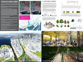
  • 1. 1) THE GREAT STREET Presently, a typical cross section of the Gardiner Expressway/Lake Shore Boulevard corridor is more than 80% asphalt or concrete surfacing and structure for cars, trucks, and buses, with less than 20% devoted to planting, sidewalks and/or the public realm. The design of the new Great Street revises this ratio, devoting nearly 60% of the corridor to the public realm and/or planting and green-space. Sidewalks are widened from their typical existing 2-4m dimension to a minimum of 6m, allowing for generous shade tree planting, furnishing and signage. Local traffic is separated to the outside from thru traffic at the center, reducing vehicular speeds adjacent to pedestrian zones. An additional buffer between the public realm on the southern edge adjacent to development and the vehicular corridor is established by the 10m wide “Lake Shore Boulevard Promenade” comprising devoted lanes for bicycles and pedestrians, as well as generous areas for planting and furnishing. The area adjacent to the rail berm on the northern edge of the Boulevard varies in dimension over the length of the corridor. However, where feasible the berm is retrofitted with a sculptural, modular planting system that creates an iconic green wall running from the Don River, west to Yonge Street. This Green Wall is envisaged as a tall constructed escarpment, with woodland lantings, stormwater terraces and vertical gardens. This strip, in combination with the promenade and the tree-planted median further enhances the overall greening of the Lake Shore Boulevard corridor. Today, Lake Shore Boulevard is a confusing ensemble of vehicular signage and over-scaled highway elements with few places to stop, sit and rest. The widening of the public realm and introduction of regularized pedestrian crossings will begin to alleviate much of this cacophony. Importantly, the use of bold paving, iconic tree planting, bespoke furnishing, transit shelters, bicycle racks, trash cans, bollards, lighting fixtures and signage will enhance the legibility and amenity of the corridor for social pedestrian uses. The removal of the Gardiner Expressway is major step toward re-connecting the city and neighborhoods of Toronto to the Lakefront. It is a major step toward returning the city to people, to the pedestrian and to civic spaces that citizens are proud of and can relate to in a positive way. We propose a simple, grand, tree-lined street to replace the Gardiner. Generously sized allees of Oak, Maple and Linden line the new 2.5-mile long street, running from Yonge to Leslie Street. Welcoming and safe pedestrian intersections encourage linkage from the neighborhoods to the Lakefront. THE TRAFFIC EQUATION: “EXPRESSWAY TO STREET” Reducing the number of traffic lanes from the existing situation (8 on the Gardiner, plus 6 on Lake Shore Blvd, for a sum of 14, or even 16 with turning and exit lanes) to a sum of 8 street-lanes requires a radical shift in mindset. The new Grand Street is no longer a massive, free-flowing mobility corridor oriented solely to the automobile, but is now a humanized civic street where pedestrians and traffic both work together. The reduction in vehicular capacity is between 35% and 45%, and will obviously need to be accommodated for regionally. This can be achieved by 1) increasing flow off the Don River Parkway at the Bloor Street and Eastern/Richmond exits; 2) improving alternative public transit systems; and 3) spreading the “peak” times. Taking down the Gardiner must be understood as just one movement in the larger symphony of shifting the transportation paradigm of Greater Toronto. Reduced capacity and travel times will be compensated for through the creation of a more pedestrian-friendly, inter-connective, urban civic street that improves the quality of life for residents, enhances property values and allows the city to leverage its biggest asset – the lakefront. THE EXPERIENCE OF THE SITUATION TODAY Mr. Chakrabarti, Daily Commuter (personal car): “Driving south along the Don Valley in the morning is frustrating; travel speeds are slow and I feel like all the congestion leads people to drive super aggressively and unsafely.” Ms. Walker, Cyclist: “The corridor is definitely more of a barrier than it is an amenity for cyclists. The high levels of congestion and frequent ramps connecting to Lake Shore from the Gardiner and Don Valley make this a place I go out of my way to avoid.” Mr and Mrs. Hu, Residents: “The area feels like it has potential to be a great waterfront; the only problems being everything except for the water. We’ve lived here for 15 years and still have a hard time figuring out how to get down to the Lake safely.” THE EXPERIENCE OF THE PROPOSED NEW GRAND STREET Ms. Moddrell, Daily Commuter (personal car): “The trip along Lake Shore Boulevard has certainly become much more enjoyable. My travel time may be a few minutes longer, but the reduced congestion and improved clarity of circulation have made a world of difference.” Mr. and Mrs. Massoud, Cyclists: “We don’t fear for our lives anymore! The super-wide median with a fully protected bicycle path is a great amenity for cyclists.” Mr. and Mrs. Lee, Residents: “The new Lake Shore Boulevard creates a real sense of place. I could never have imagined living around here 10 years ago. The newly designed gateways along the north-south streets make getting down to the water completely intuitive” TORONTO’S GREAT STREET THE LAKE SHORE BOULEVARD CORRIDOR AUTUMN AFTERNOON ACTIVITY ALONG LAKE SHORE BLVD. PROMENADE NIGHT VIEW OF RECONFIGURED BLVD. FROM ELEVATED PEDESTRIAN CROSSINGOVERVIEW OF CORRIDOR SHOWING IMPROVED DEVELOPMENT FRONTAGES CONCRETE BARRIER (60M) VEGETATED RIBBON (60M) distinctive paving iconic species bespoke funishing reconfigured section existing section In order to achieve the great street vision, our approach is rooted in three primary operations: 1) RECONFIGURE THE LAKE SHORE BOULEVARD CORRIDOR TO CREATE TORONTO’S GREAT EAST-WEST STREET 2) ESTABLISH AND DEMARCATE BOLD NEW NORTH-SOUTH PEDESTRIAN CONNECTIONS BETWEEN NEIGHBORHOODS AND THE WATERFRONT 3) REALIGN THE VEHICULAR STREET SUCH THAT NEW URBAN DEVELOPMENT MAXIMIZES FRONTAGE, PUBLIC SPACE AND VALUE;
  • 2. 2) N-S NEIGHBOURHOOD CONNECTIONS 3) REALIGNMENT + ENHANCED FRONTAGE In addition to the reconfiguration at the Keating Precinct, the overall diminishing of the Lake Shore Boulevard Corridor allows for adjacent development to occur without fear of adverse impact from an adjacent urban expressway. In essence, the corridor is shifted from being a detriment to development, to enhancing its potential and overall quality – a new green threshold to the waterfront. To the east of the Don Valley Parkway, this reconfiguration results in the possibility of extending the existing neighborhood block structure to the north south across Lake Shore Boulevard, potentially all the way to the Port Land’s ship channel. The Gardiner is not the only barrier to pedestrian movement from the north, south to the waterfront; the GO Transit rail berm is an equally significant obstacle to waterfront access because of its limited number of crossings and their diminutive scale. In order to overcome these barriers to movement - both physical and perceptual - clear articulation of existing crossing points is necessary, as well as the introduction of new typologies of crossing. We propose that each of the underpasses at Jarvis, Sherbourne, Parliament and Cherry are retrofitted with an architectural sleeve that announces the presence of the public access point; illuminates its volume; and demarcates that particular entry to the Waterfront District. These media sleeves are part of a larger streetscape strategy that extends the paving and furnishing of the Lake Shore Boulevard north into the existing neighborhoods of the City. Paired with a distinct planting regime and a unique urban floor, these north-south thoroughfares are recognized as the gateways from the neighborhoods to the Waterfront. In addition to the existing crossing points, we also propose the introduction of three new typologies of crossing at strategic points along the length of the corridor. These crossings take the form of architectural objects and include large-scale signage; iconic pedestrian bridges; and at Cherry Street, a new 21st century Ponte Vecchio - a fully programmed mixed-use cultural building that links the Distillery District directly with the Lower Don Lands development. While generally the alignment of the proposed Lake Shore Boulevard follows that of the existing Gardiner Expressway, the one location where it has been modified significantly improves the overall development opportunity of the adjacent blocks. Rather than allowing the corridor to cut directly through the development of the Keating Channel Precinct - cutting off development from the water and isolating the portion adjacent to the rail yards - we shift the Lake Shore Boulevard corridor to the northern edge of the precinct adjacent to the line of the rail berm. This move has two significant results: The first is that the two transportation corridors (rail and vehicular) are aligned and bundled, lessening their impact on adjacent development parcels. The second is that Keating Channel precinct is no longer cut in half by a major vehicular artery, and the entire length of the precinct has frontage on the Keating Channel rather than only 50% allowing for the 18m minimum public right of way to be continued from Downtown all the way to mouth of the Don River. This move dramatically improves the overall development potential of the precinct, and consolidates the buildings into a coherent series of blocks. ICONIC UNDERPASS AT RAIL BERM WINTER ACTIVITY ALONG LOCAL STREETS SCULPTED VEGETAL RAIL BERM AND STORMWATER ESCARPMENT EXPANDED PUBLIC FRONTAGE ALONG KEATING CHANNEL WATERFINGERMORPHOLOGY 线性滨水走廊的若干形态 WATERCITY|InternationalConsultancyofConceptualPlanningofQianHaiRegion25 WATERFINGERMORPHOLOGY 线性滨水走廊的若干形态 WATERCITY|InternationalConsultancyofConceptualPlanningofQianHaiRegion25 OBSTRUCTED FRONTAGE CONTINUOUS PUBLIC FRONTAGE sculpted vegetal rail berm escarpment eastern lake shore boulevard: extend neighborhoods to the water underpass media sleeves “Ponte Vecchio” typology corridor composition - structures + walls keating precinct detail gateway signage typology pedestrian bridge crossing typology revised keating channel precinct massing
  • 3. 1 2 3 1 2 3 BAY STREET INTERSECTION (GRADE TO ELEVATED CONNECTION) SHERBOURNE STREET INTERSECTION (TYPICAL WESTERN INTERSECTION) PARLIAMENT STREET INTERSECTION AND CROSSING
  • 4. 4-5 6 4 5 6 DON VALLEY PARKWAY INTERSECTION DON VALLEY PARKWAY - LAKE SHORE BOULEVARD INTERSECTION CARLAW AVENEUE INTERSECTION (TYPICAL EASTERN INTERSECTION)